
Danger
Extreme Heat Advisory
The National Weather Service has issued extreme heat warnings and advisories for Wednesday, July 1, through Friday, July 3, which will produce dangerous conditions. Some people will face a higher risk of heat-related illness due to underlying medical conditions or certain activities. Dress cool, stay hydrated, and limit exertion. Watch for dizziness, nausea, headaches, shortness of breath, confusion, rapid pulse, and fainting. If you or someone else experiences signs of heat stroke, call 911 immediately.
Park Closure
Several Trails Close For Peregrine Falcon Nesting Season
Effective March 1, areas including Jordan Cliffs Trail, Penobscot East Trail, Precipice Trail, and Valley Cove Trail are closed to protect nesting peregrine falcons. The parking lot for the Precipice Trail is also closed. Rangers strictly enforce closures.
More infoAcadia National Park
ME · Bar Harbor
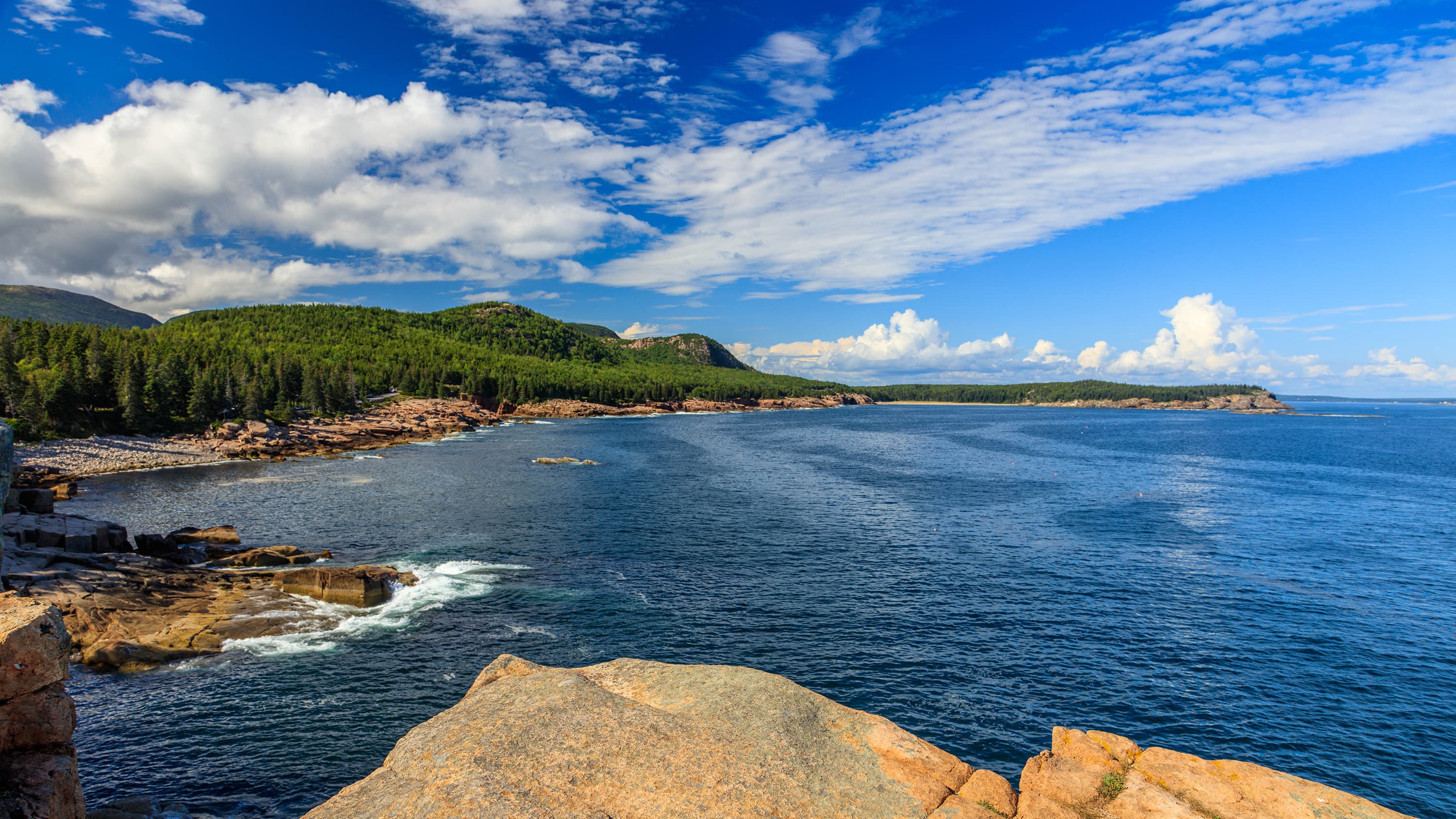
Acadia National Park protects the natural beauty of the highest rocky headlands along the Atlantic coastline of the United States, an abundance of habitats, and a rich cultural heritage. At 4 million visits a year, it's one of the top 10 most-visited national parks in the United States. Visitors enjoy 27 miles of historic motor roads, 158 miles of hiking trails, and 45 miles of carriage roads.
Riding guide
Horses provided
Highlights
Acadia National Park sits along the rugged coast of Maine, where granite mountains rise above the Atlantic Ocean…
Riding
Rideable terrain here is noted as 45 miles, giving riders a clearer sense of scale before they ever unload. For equestrians, Acadia offers a unique riding experience centered on its historic carriage road system, a network of motor-free roads designed in the early 1900s specifically for horse and carriage travel. Built between 1913 and 1940 by philanthropist John D. Rockefeller Jr., these approximately 45 Miles of wide crushed-stone roads wind through forests, along lakes, and around the park’s mountains.
Rideable terrain
45 miles
Trailer parking
Wildwood Stables This is the primary equestrian staging area in Acadia National Park and the most reliable place to park a horse trailer. Why riders use it: Large parking area designed for horse trailers Direct access to the park’s 45-mile carriage road system Horse stalls and equestrian campsites available Located right along the Park Loop Road near Seal Harbor The National Park Service specifically notes that Wildwood Stables and the nearby Brown Mountain parking lot provide adequate room for horse trailers. Wildwood Stables also offers: Horse boarding stalls Equestrian campsites with hookups Direct access to carriage roads used for horseback riding and carriage driving. Secondary Trailer Parking Option Brown Mountain Parking Lot Located along the carriage road network near Eagle Lake. Why it works: Large lot that can accommodate trailers Access to several carriage road loops However, most riders still prefer staging at Wildwood Stables because it is the park’s official equestrian facility.
Horse regulations
Horse Use Regulations Horseback riding is permitted in Acadia National Park primarily on the park’s historic carriage road system, a network of motor-free roads originally designed for horse-drawn travel. Riders must follow regulations intended to protect the historic roads, natural resources, and safety of other visitors. Horses Allowed on Carriage Roads Only Horseback riding is allowed on the park’s approximately 45 Miles of carriage roads. Horses are not permitted on most hiking trails, mountain paths, or fragile natural areas. The carriage roads are the main equestrian travel routes within the park. These roads are wide crushed-stone surfaces designed for shared use by: Horseback riders Horse-drawn carriage tours Hikers Bicyclists Riding Is Prohibited on Motor Roads Horses are not allowed on: Park Loop Road Other paved vehicle roads Most developed visitor areas Riders must stay on designated carriage roads and approved access points. Stock Definition For park regulations, stock animals include: Horses Mules Burros Other animals are not permitted for stock travel. Feed Requirements To prevent the spread of invasive plant species, riders must use: Certified weed-free hay or feed Trailers, tack, and horses should also be cleaned before entering the park. Horse Boarding and Facilities Horses are typically boarded or staged at: Wildwood Stables, the park’s primary equestrian facility Wildwood Stables provides: Horse stalls Equestrian campsites Direct access to the carriage road system Trail Courtesy Because the carriage roads are multi-use, riders must follow shared trail etiquette: Slow to a walk when approaching other users Yield when appropriate Maintain control of horses around bicycles and pedestrians Horse-drawn carriage tours operate regularly on these roads, and riders should allow them safe passage. Protecting the Historic Roads The carriage roads are historic structures and must be preserved. Riders should: Avoid riding during extremely muddy conditions Stay on the road surface rather than shoulders or vegetation Follow posted closures or maintenance notices
Getting here
Use 25 Visitor Center Road, Bar Harbor, Maine as your primary planning reference before you haul in. Wildwood Stables This is the primary equestrian staging area in Acadia National Park and the most reliable place to park a horse trailer. Why riders use it: Large parking area designed for horse trailers Direct access to the park’s 45-mile carriage road system Horse stalls and equestrian campsites available Located right along the Park Loop Road near Seal Harbor The National Park Service specifically notes that Wildwood Stables and the nearby Brown Mountain parking lot provide adequate room for horse trailers. Wildwood Stables also offers: Horse boarding stalls Equestrian campsites with hookups Direct access to carriage roads used for horseback riding and carriage driving. Secondary Trailer Parking Option Brown Mountain Parking Lot Located along the carriage road network near Eagle Lake. Why it works: Large lot that can accommodate trailers Access to several carriage road loops However, most riders still prefer staging at Wildwood Stables because it is the park’s official equestrian facility.
Planning your visit
Granite Mountains Define the Landscape Acadia contains 26 prominent granite mountains, primarily located on Mount Desert Island. These peaks range from about 284 to 1,530 feet in elevation and form the scenic backbone of the park. Two major mountain regions shape the park experience: East side peaks: Cadillac Mountain, Dorr Mountain, and Champlain Mountain are among the most visited areas. Quieter west side peaks: Beech Mountain and Mansell Mountain offer a more remote feel. The highest summit in the park is Cadillac Mountain, followed by Sargent Mountain and Pemetic Mountain. Although these mountains define the skyline of Acadia, horseback riding usually takes place on the lower forested terrain surrounding the mountains rather than on the steep hiking routes that climb to the summits. Trail Surfaces Vary Across the Park Many hiking trails in Acadia cross exposed granite and glaciated rock, which can be extremely steep and rugged. These mountain routes are generally not suitable for horses. Across the park you will encounter several types of trail surfaces: Exposed and uneven granite slabs on mountain hiking trails Rocky or gravel coastal paths Boardwalk sections and stone steps on popular routes such as Jordan Pond Equestrian riders primarily use the carriage roads, which are wide crushed-stone surfaces designed for horses and carriages and offer much gentler grades than the mountain trails. Lakes and Ocean Access Are Major Park Attractions Water plays an important role in the park’s landscape. Visitors will encounter both coastal Atlantic shoreline and freshwater lakes. Two of the most popular swimming locations include: Sand Beach, a scenic ocean beach along the Atlantic coastline Echo Lake Beach, a freshwater lake beach Both locations typically provide lifeguards from Memorial Day through Labor Day. While horses are not allowed on these beaches, these areas are some of the most visited destinations in the park and contribute to the overall visitor experience. The Carriage Roads Are the Main Riding Routes The park’s 45-mile carriage road network forms the heart of equestrian travel in Acadia. These historic roads wind through forests, around lakes, and across beautiful stone bridges built in the early twentieth century. Because these roads were originally designed for horse-drawn travel, they provide: Gentle grades Wide travel corridors Scenic views of lakes and mountains Most horseback riding trips will focus on exploring these quiet forest roads. Expect Busy Summer Seasons Acadia is one of the most visited national parks in the northeastern United States. Summer and early fall can bring heavy visitation. Riders should plan for: Busy parking areas during peak months Shared trail use with hikers and cyclists Early arrival for staging areas such as Wildwood Stables Fall foliage season is especially popular and can significantly increase visitation.
Where to stay
Hulls Cove Visitor Center is the main visitor-contact point tied to this destination, which is helpful when you want current conditions, maps, and stock-use updates before riding. Guided or concession-based riding support is noted here, so riders who are not hauling their own horses may still find an access path into the experience. For a polished trip plan, pair the ride with lodging, fuel, and resupply planning in or near Bar Harbor before heading deeper into federal-land access points.
Entrance fees & passes
- $6.00
Timed Entry Reservation - Location
Vehicle reservations are not required for any other areas of the park, or for visitors who enter the area by foot, bike, or taxi. Vehicle reservations provide a timed entry, but do not require a departure time until 9 pm, when the road closes to vehicles. Reservations do not permit re-entry. Reservations are per vehicle, not per person. Reservations do not assign a specific parking space. Parking is prohibited outside of designated spaces. Cadillac is not served by the Island Explorer bus system.
- $35.00
Entrance - Private Vehicle
Valid for seven days. Admits private, non-commercial vehicle (15 passenger capacity or less) and all occupants. This includes rental cars, RVs, and vans with fewer than 16 passengers. If the vehicle pass is purchased, no other pass is necessary.
- $30.00
Entrance - Motorcycle
Valid for 7 days. Admits up to 2 private, non-commercial motorcycles with up to 4 total passengers.
- $20.00
Entrance - Per Person
Valid for seven days. Admits one individual with no car (bicyclist, hiker, pedestrian). Youth 15 and under are admitted free of charge.
- $0.00
Entrance - Education/Academic Groups
School groups and other academic institutions may qualify for an Educational Fee Waiver. If not qualified, please check fees for large or commercial groups.
- $0.00
Entrance - Non-commercial Groups
Groups entering Acadia by bus, van, or other high-capacity vehicles (16 people or more) must pay an organized group entrance fee. Adults (16 years old and over): $20/per person Youth (15 years old and under): Free
- $20.00
Commercial Entrance - Per Person
Are you operating a business that provides leisure or recreational services while in the park? If so, it is considered a commercial group and you are required to have a Commercial Use Authorization. A commercial group is defined as consisting of one or more persons traveling on an itinerary that has been packaged, priced, or sold for leisure or recreational purposes by an organization that realizes financial gain through the provisions of the service. Learn more on our "Do Business With Us" page.
- $100.00
Nonresident
Each non-US resident aged 16 and older visiting Acadia National Park must pay a $100 nonresident fee (in addition to the standard entrance fee), unless they are admitted with an Annual or America the Beautiful Pass. This includes nonresidents entering as part of a commercial tour group, commercial use authorization (CUA) group, or concessioner tour group.
- $70.00
Annual Entrance - Park
The Acadia Annual Pass is valid only at Acadia and may be purchased online or in person. You do not need an additional entrance pass if you already have a federal lands pass. It is valid for 12 months from purchase month. This pass admits the pass holder and passengers in a non-commercial vehicle. In addition to park visitor centers and campgrounds, the Acadia Annual Pass is available at the Acadia Regional Chamber at Thompson Island, and at Bar Harbor, Ellsworth and Southwest Harbor chambers of commerce.
Park map
Trails
No trails synced for this park yet.
Campgrounds
Blackwoods Campground
281 sites
Blackwoods Campground is located on the east side of Mount Desert Island, about 5 miles (8 km) south of Bar Harbor on Route 3. All sites at Blackwoods are wooded and within a 10-minute walk of the ocean. The majority of Blackwoods' sites are for small and large tents; other sites can accommodate travelers with RVs. Flush toilets, running water, and a dump station are provided, as are picnic tables and fire rings. Roads are paved.
Reserve a siteDuck Harbor Campground
5 sites
Duck Harbor Campground is located on Isle au Haut, a rugged island off the coast of Stonington, Maine. This campground has five sites with lean-to shelters and is a great launch point for paddling excursions. Remote and inaccessible to automobiles, Isle au Haut is linked to the mainland by mailboat.
Reserve a siteSchoodic Woods Campground
89 sites
Schoodic Woods Campground is the newest campground in the park and located 1.5 miles (2.5 km) southeast of Winter Harbor on the Schoodic Peninsula. It is approximately 60-70 minutes from Bar Harbor and other areas of Mount Desert Island.
Reserve a siteSeawall Campground
202 sites
Seawall Campground is located on the west side of Mount Desert Island about 4 miles (6 km) south of Southwest Harbor. The campground is approximately 18 miles from Bar Harbor. All sites at Seawall are within a short walking distance of the coastline.
Reserve a site
Points of interest
Acadia Earthcache Course Stop Five: Champlain Mountain
POIStop five on the Acadia Geocache course.
Acadia Earthcache Course Stop Four: Gorham Mountain Trail
POIThe fourth stop on Acadia National Park's Geocache course.
Acadia Earthcache Course: Stop One - Somes Sound
POIThe first stop along Acadia's Geoacache course.
Acadia Earthcache Course Stop Three: Jellybean Glacial Erratic
POIThe third stop of Acadia National Park's Geocache Course.
Acadia Earthcache Course Stop Two: Bubble Rock
POIStop Two on the Acadia Geocache Tour.
Acadia Gateway Center
POIAcadia Gateway Center Accessibility Information
POIA description of the Acadia Gateway Center including accessibility information, amenities, and general orientation.
Acadia Mountain Trailhead
POIThis is the trailhead for Acadia Mountain, a 681 ft mountain located on the west side of Mount Desert Island. The trailhead is on Maine Route 102, about 3 miles south of Somesville and just after Ikes Point Boat Launch.
Acadia National Park
POIAcadia Trails Memorial Plaque
POIThis memorial plaque is dedicated to Ruth and Tris Colket. Both were philanthropists who saw the need for an endowed trail system and made a gift of $5 million to Friends of Acadia for restoration and maintenance of Acadia’s historic trail system.
Alessandro Fabbri Plaque
POIAlessandro Fabbri is most remembered at Acadia for establishing the Otter Cliffs Radio Station in 1917.
Amphitheatre Bridge (I)
POIAmphitheatre Bridge (1931) is the largest of 17 bridges constructed along 57 miles of carriage road on Mount Desert Island between 1917 and 1940. It carries Amphitheatre Road (Asticou-Jordan Pond Road) -- which itself had been abandoned for ten years due to the objections of summer residents -- near the Little Harbor Brook waterfall.
Andrew Murray Young Memorial Plaque
POIAndrew Murray Young was a member of the Bar Harbor Village Improvement Association’s Roads and Paths Committee.
Atwater Kent Memorial Plaque
POIThis memorial plaque is dedicated to Atwater Kent who donated 62 acres known as Bliss Field off Schooner Head Road to Acadia. It is now designated as Atwater Kent Field.
Bass Harbor Head Light Station
POIThe Bass Harbor Head Light Station is located in Tremont, Maine, marking the entrance to Bass Harbor and Blue Hill Bay on the southwest corner of Mount Desert Island.
Bass Harbor Head Light Station Accessibility Information
POIA description of Bass Harbor Head Light Station including accessibility information, amenities, and general orientation.
Bass Harbor Head Light Station Parking Lot Accessibility Information
POIAn accessible description and transcript of Bass Harbor Head Light Station in Acadia National Park. (February 2025)
Bear Brook Picnic Area Accessibility Information
POIA description of Bear Brook Picnic Area including accessibility information, amenities, and general orientation.
Beech Mountain
POILocated between Long Pond and Echo Lake, Beech Mountain rises to an elevation of 839 feet with a fire tower located near the summit that was used as a lookout from 1941 to the mid-1950s.
Beehive Overlook
POIBlue Duck Ships Store
POIThe Blue Duck Ships store was first constructed as a store to sell essential supplies to the residents of Islesford, Little Cranberry Island, Maine in the 1850s. It also served the 'maritime highway' of trade. Today, the store is used by Islesford Boatworks, a non-profit that continues the tradition of boat building by teaching boat building skills to Island youth.
Brown Mountain Gatehouse
POIBrown Mountain Gatehouse, and its counterpart, Jordan Pond Gatehouse, were built to mark the entrance to Acadia historic carriage road network. Though never put into practice as true 'gatekeepers' to the carriage roads, these architectural marvels are a beautiful and whimsically quaint introduction to the near-fantasy of the carriage roads.
Brown Mountain Parking Lot Accessibility Information
POIAn accessible description and transcript of the Brown Mountain Parking Lot in Acadia National Park. (February 2025)
Bubble Pond Bridge (D)
POIBubble Pond Bridge (1928) was the tenth of 17 bridges constructed along 57 miles of carriage road on Mount Desert Island between 1917 and 1940. It carries the Bubble Pond Road over a portion of the Jordan Pond/Eagle Lake motor road that was abandoned when that road was realigned in 1962-1964. This bridge is now a relic with no function. Access to a parking lot along the shore of Bubble Pond remains.
Cadillac Mountain
POICadillac Mountain is a popular destination for visitors to Acadia National Park. Accessible by car, it is the highest point on the eastern seaboard of the U.S., and offers magnificent views of a glaciated coastal and island landscape. The short, paved Cadillac Summit Loop Trail, interpretive waysides, restrooms, and gift shop are located at the summit. In the summer, reservations are required to drive to the summit.
Cadillac Summit Accessibility Information
POIA description of Cadillac Summit Loop including accessibility information, amenities, and general orientation.
Carroll Homestead
POIThe Carroll Farm represents changing farm life during the 19th and early 20th century on Mount Desert Island. The house was built by John and Rachel Carroll in 1820 and remained in the family until its purchase by the Maine Coast Heritage Trust and later by the park.
Carroll Homestead Accessibility Information
POIA description of Carroll Homestead including accessibility information, amenities, and general orientation.
Charles W. Eliot Memorial Plaque
POICharles William Eliot was a founder of the Hancock County Trustees of Public Reservations and his preservation efforts were largely inspired by the death of his son, who founded the Champlain Society.
Chasm Brook Bridge (C)
POIChasm Brook Bridge (1926) was the seventh of 17 bridges constructed along 57 miles of carriage road on Mount Desert Island between 1917 and 1940. It carries Jordan-Sargent Mountain Road over Chasm Falls. It was the last of four bridges required along the Jordan-Sargent Mountain Road.
Civilian Conservation Corps Memorial Plaque
POIThe Civilian Conservation Corps (CCC) helped improve park areas including construction, forestry work, roadside cleanup and revegetation.
Cliffside Bridge (L)
POICliffside Bridge (1932) is one of 17 bridges constructed along 57 miles of carriage road on Mount Desert Island between 1917 and 1940. It carries Amphitheater Road (Asticou-Jordan Pond Road) over a ravine on the flank of Jordan Mountain along a road between Amphitheater and West Branch bridges.
Cobble Beach
POIThis beach is not protected by any landforms and gets hammered with waves all day. Only the cobbles remain because their larger size makes them resistant to these strong waves.
Cobblestone Bridge (O)
POILocated on private land outside park boundaries on the Gardiner-Mitchell Hill-Jordan Stream Road, Cobblestone Bridge (1917) was the first of 17 bridges constructed along 57 miles of carriage road on Mount Desert Island between 1917 and 1940.
Compass Harbor Accessibility Information
POIA description of Compass Harbor Trail including accessibility information, amenities, and general orientation.
Compass Harbor Parking Lot Accessibility Information
POIAn accessible description and transcript of the Compass Harbor Parking Lot in Acadia National Park. (February 2025)
Deer Brook Bridge (E)
POIDeer Brook Bridge (1925) was the sixth of 17 bridges constructed along 57 miles of carriage road on Mount Desert Island between 1917 and 1940. The bridge carries the Jordan-Sargent Mountain Road over Deer Brook at a waterfall near the north end of Jordon Pond.
Duck Brook Bridge (A)
POIDuck Brook Bridge (1929) was the 11th of 17 bridges constructed along 57 miles of carriage road on Mount Desert Island between 1917 and 1940. It carries the Witch Hole Pond Loop portion of the Hulls Cove Road over Duck Brook to connect with New Eagle Lake motor road. John D. Rockefeller, Jr. considered this area the “grand northern terminus” of his carriage road system and planned magnificent vistas of Frenchman Bay from this road and the adjacent Paradise Hill Loop Road.
Duck Brook Parking Accessibility Information
POIAn accessible description and transcript of Duck Brook parking in Acadia National Park. (February 2025)
Eagle Lake Boat Ramp Parking Accessibility Information
POIAn accessible description and transcript of the Eagle Lake Boat Ramp in Acadia National Park. (February 2025)
Eagle Lake Bridge (B)
POIEagle Lake Bridge (1927) was the ninth of 17 bridges constructed along 57 miles of carriage road on Mount Desert Island between 1917 and 1940. It carries Route 233 over the Hulls Cove carriage road. Its completion made possible the construction of new carriage roads on lands north of Eagle Lake, where John D. Rockefeller, Jr. planned magnificent views of Frenchman Bay.
Eagle Lake Carriage Road Entrance Parking Accessibility Information
POIAn accessible description and transcript of the Eagle Lake Carriage Road Entrance in Acadia National Park. (February 2025)
Echo Lake
POIEcho Lake is a Great Pond located on the west side of Mount Desert Island. Visitors can swim, boat, kayak, fish, and view wildlife.
Echo Lake Beach Accessibility Information
POIA description of Echo Lake Beach including accessibility information, amenities, and general orientation.
Edward Lothrop Rand Memorial
POIA plaque dedicated to early Acadia National Park botanist, map maker and trail builder, Edward Lothrop Rand.
Entrance Station on Acadia's Park Loop Road
POILocated near the intersection of Schooner Head Road, the entrance station along Acadia's Park Loop Road is open year-round and offers full-service sales and information about park entrance fees, the Acadia Annual Pass, and all federal recreational lands passes. Staff can provide basic information, the Unigrid brochure and other park publications. Nearby destinations include several trailheads, Sand Beach, Thunder Hole, Otter Cliff and the Fabbi Picnic Area.
Estuary Behind Dunes
POIFabbri Picnic Area and Memorial Accessibility Information
POIA description of Fabbri Picnic Area and Memorial including accessibility information, amenities, and general orientation.
Flying Mountain Trailhead
POIThe Flying Mountain Trailhead is located north of Southwest Harbor, ME off State Route 102 via Fernald Point Road. It directly serves Flying Mountain and Valley Cove Trails with connections to Valley Peak Trail and Saint Sauveur Mountain Trail.
George B. Dorr Plaque
POIGeorge B. Dorr devoted most of his adult life and fortune to securing and protecting the lands that would later become the park. He was Acadia National Park’s first superintendent.
Gorham Mountain Parking Loop Accessibility Information
POIAn accessible description and transcript of the Gorham Mountain Parking Loop in Acadia National Park. (February 2025)
Gorham Mountain Parking Lot Accessibility Information
POIAn accessible description and transcript of the Gorham Mountain Parking Lot in Acadia National Park. (February 2025)
Great Head Parking Loop Accessibility Information
POIAn accessible description and transcript of the Great Head Parking Loop in Acadia National Park. (February 2025)
Hadlock Brook Bridge (H)
POIHadlock Brook Bridge (1926) was the eighth of 17 bridges constructed along 57 miles of carriage road on Mount Desert Island between 1917 and 1940.
Hemlock Bridge (F)
POIHemlock Bridge (1924) was the fourth of 17 bridges constructed along 57 miles of carriage road on Mount Desert Island between 1917 and 1940. It carries the Jordan-Sargent Mountain Road over a deep, rocky ravine created by the Maple Spring Brook. The difficult, yet spectacular site conditions necessitated careful ground inspection and preliminary staking to ensure that the site was not adversely affected by construction.
Hints of the Satterlee Estate
POIHulls Cove Visitor Center
POIHulls Cove Visitor Center is Acadia National Park's primary visitor contact station. Hundreds of thousands of visitors a year take their first 'hike' in Acadia up the 52 steps to the main visitor center entrance.
Hulls Cove Visitor Center Accessibility Information
POIA description of Acadia's Hulls Cove Visitor Center including accessibility information, amenities, and general orientation.
Hulls Cove Visitor Center Parking Lot Accessibility Information
POIA video, accessible description and transcript of the Hulls Cove Visitor Center parking lots and entrance spaces in Acadia National Park. (February 2025)
Islesford Historical Museum
POIIslesford Historical Museum is located on Little Cranberry Island, accessible by mail boat or tour boat from Northeast Harbor or Southwest Harbor. Exhibits tell the story of changing island life, schooner empires, summer residents, and the fishing industry. The museum is open seasonally and has interpretive exhibits, ranger programs, restrooms, and a gift shop.
Jesup & Hemlock Path Loop Accessibility Information
POIA description of Acadia's Jesup and Hemlock Path Loop including accessibility information, amenities, and general orientation.
Jesup Memorial Plaque
POIMorris K. Jesup and Maria DeWitt Jesup. Both were philanthropists who gave generously to projects that benefited both the park and the community of Mount Desert Island.
John D. Rockefeller Memorial Plaque
POIJohn D. Rockefeller Jr. was a businessman and philanthropist, responsible for many creations of and contributions to national parks across the country.
John Godfrey Moore Memorial Plaque
POIJohn Godfrey Moore purchased over 2,000 acres on Schoodic Peninsula, and built roads and trails on the peninsula.
Jordan Pond Dam Bridge (K)
POIThe Jordan Pond Dam Bridge (1920) was the third of 17 bridges constructed along 57 miles of carriage road on Mount Desert Island between 1917 and 1940. The bridge carries Asticou-Jordan Pond Road across Jordan Stream adjacent to a small dam at the southwest corner of Jordan Pond.
Jordan Pond Gatehouse
POIJordan Pond Gatehouse, and its counterpart, the Brown Mountain Gatehouse, were built in 1932 to mark the entrance to Acadia's historic carriage road network. Though never put into practice as actual 'gatekeepers' to the carriage roads, these impressive structures are a whimsical and quaint introduction to the near-fantasy beauty of the carriage paths.
Jordan Pond House
POIJordan Pond House is located on the picturesque southern end of Jordan Pond. It has been a scenic, recreational, and dining destination since the nineteenth century.
Jordan Pond House Parking Areas Accessibility Information
POIA video, accessible description and transcript of the Jordan Pond House parking lots and surrounding access paths in Acadia National Park. (February 2025)
Jordan Pond Road Bridge (Q)
POIJordan Pond Road Bridge (1932) is one of 17 bridges constructed along 57 miles of carriage road on Mount Desert Island between 1917 and 1940. It carries the Seal Harbor (formerly Jordan Pond) road over the Day Mountain Carriage Road to provide a greater separation and sense of seclusion for the carriage road. As such the underside was faced with stone but the deck above for the town road was not ornamented.
Joseph Allen Memorial Plaque
POIJoseph Allen was a member of Hancock County Trustees of Public Reservation and chairman of Seal Harbor Village Improvement Society Roads and Paths Committee.
Keyhole Parking Area Accessibility Information
POIAn accessible description and transcript of the Keyhole Parking Area in Acadia National Park. (February 2025)
Kurt Diederich Memorial Plaque
POIBuilt in memory of Kurt Diedrerich, a grandson of Boston artist William Hunt, and a gift of his aunt, Mrs. Hunt Slater, the Climb was the first of several memorial paths created by George Dorr in conjunction with Bar Harbor via members. The 700-step climb contains the largest rocks ever used on any Acadian trail and a bronze marker.
Little Harbor Brook Bridge (N)
POIThe Little Harbor Brook Bridge (1919) was the second of 17 bridges constructed along 57 miles of carriage road on Mount Desert Island between 1917 and 1940. It is located on Little Harbor Brook Road for a section of carriage road connecting Jordan Pond with Brown Mountain Road over a shallow and rocky brook deep in the woods.
Little Hunters Beach
POILittle Hunters Beach is a cobblestone beach located off the Park Loop Road, southeast of Otter Point and Otter Cove.
Nature Center Accessibility Information
POIA description of Sieur de Monts Nature Center including accessibility information, amenities, and general orientation.
Ocean Drive Parking Loop Accessibility Information
POIAn accessible description and transcript of the Old Soaker Parking Loop in Acadia National Park. (February 2025)
Ocean Path Accessibility Information
POIA description of Ocean Path including accessibility information, amenities, and general orientation.
Oldfarm 10: Oldfarm House
POIOldfarm House
Oldfarm 11: A Place of Historic Repose
POIA Place of Historic Repose
Oldfarm 1: Meet George Dorr
POIWelcome to Oldfarm, a historic cultural landscape that encompasses the Dorr Family Estate site, including the remains of the family's main home. This video tour will give you a sense of the life and motivations of George Bucknam Dorr, the founder of Acadia National Park who lived here on the Oldfarm estate until his death in 1944.
Oldfarm 2: Transition From City Life to Island Life
POITransition from City Life to Island Life
Oldfarm 3: The Quiet Beauty of Island Life
POIThe Quiet Beauty of Island Life
Oldfarm 4: Early Preservation of Mount Desert Island
POIEarly Preservation of Mount Desert Island
Oldfarm 5: Origins of Acadia National Park
POIOrigins of Acadia National Park
Oldfarm 6: Hospitality & Importance of Oldfarm
POIHospitality & Importance of Oldfarm
Oldfarm 7: Dorr's Family Inheritance
POIDorr's Family Inheritance
Oldfarm 8: Sieur de Monts National Monument
POISieur de Monts National Monument
Oldfarm 9:Passion for Gardening
POIPassion for Gardening
Old Soaker Overlook
POIOtter Cliff Parking Lot Accessibility Information
POIAn accessible description and transcript of the Otter Cliff Parking Lot in Acadia National Park. (February 2025)
Otter Creek Cove Parking Accessibility Information
POIAn accessible description and transcript of Otter Creek Cove parking in Acadia National Park. (February 2025)
Otter Point Parking Lot Accessibility Information
POIAn accessible description and transcript of the Otter Cliff Parking Lot in Acadia National Park. (February 2025)
Parkman Mountain Parking Lot Accessibility Information
POIAn accessible description and transcript of the Parkman Mountain Parking Area in Acadia National Park. (February 2025)
Pretty Marsh Picnic Area Accessibility Information
POIAn accessible description and transcript of the Pretty Marsh Entrance Acadia National Park. (February 2025)
Ranger Karl A. Jacobson Memorial
POIA memorial to Ranger Karl Jacobson who was killed while on duty at Acadia National Park in November of 1938.
Robert Abbe Memorial Plaque
POIRobert Abbe was a physician, friend of George Dorr, and a summer resident of Bar Harbor. He assembled a collection of early Native American artifacts found in the Frenchman Bay area and established the Lafayette National Park Museum of Stone Age Antiquities.
Rockefeller Hall
POIThe Rockefeller Welcome Center at historic Rockefeller Hall offers exhibits on the naval history of Schoodic Peninsula as well as park information and souvenirs.
Samuel de Champlain Memorial Plaque
POISamuel de Champlain was a navigator and explorer. He is credited with naming Mount Desert Island.
Sand Beach
POISand Beach, the largest sandy beach in Acadia, is a popular destination on Park Loop Road.
Sand Beach Accessibility Information
POIA description of Sand Beach including accessibility information, amenities, and general orientation.
Sand Beach Parking Lot Accessibility Information
POIA video, accessible description and transcript of the Sand Beach parking lots in Acadia National Park. (February 2025)
Sand Beach Shipwreck
POILong before the dunes moved in to cover it up, the Schooner Tay shipwrecked on Sand Beach.
Satterlee Estate Millstone
POISatterlee Field
POIThe Satterlee Estate was a generous land donation made to Acadia National Park after the Fire of 1947. Today, visitors recreate on these lands and make memories with their families much like the Satterlee sisters did as they were growing up here.
Satterlee Memorial Plaque
POIEleanor Morgan Satterlee donated land to Acadia National Park in 1949 after the Fire of 1947.
Satterlee Teahouse
POISchoodic Peninsula
POISchoodic Peninsula, the only part of Acadia National Park found on the mainland, boasts granite headlands that bear erosional scars of storm waves and flood tides.
Schooner Head Overlook Parking Lot Accessibility Information
POIAn accessible description and transcript of the Schooner Head Overlook in Acadia National Park. (February 2025)
Seawall Picnic Area Accessibility Information
POIAn accessible description and transcript of the Seawall Picnic Area in Acadia National Park. (February 2025)
Shatter Zone
POIShip Harbor Accessibility Information
POIA description of Ship Harbor Trail including accessibility information, amenities, and general orientation.
Ship Harbor Parking Lot Accessibility Information
POIAn accessible description and transcript of the Ship Harbor Parking Lot in Acadia National Park. (February 2025)
Sieur de Monts Nature Center
POISieur de Monts Nature Center is one of the park visitor centers and offers various exhibits on the “science behind the scenery” of Acadia.
Sieur de Monts Parking Area Accessibility Information
POIAn accessible description and transcript of the Sieur de Monts Parking Area in Acadia National Park. (February 2025)
Stanley Brook Bridge (P)
POIStanley Brook Bridge (1933) was the 16th of 17 bridges constructed along 57 miles of carriage road on Mount Desert Island between 1917 and 1940. It carries the carriage road over the new Stanley Brook motor road as well as the Stanley Brook watercourse and the Seaside Trail. It was the last bridge designed and built by John D. Rockefeller, Jr. on the carriage road system.
Stephen T. Mather Memorial Plaque
POIStephen T. Mather was a businessman and conservationist. His vigorous efforts as the special assistant to the Secretary of the Interior helped persuade Congress to create the National Park Service in 1916. He was appointed its first director in May 1917.
The Fire of 1947
POIThe Tarn Parking Lot Accessibility Information
POIAn accessible description and transcript of the Tarn Parking Lot in Acadia National Park. (February 2025)
Thunder Hole
POIThunder Hole, a popular destination year-round, is a carved out inlet along the rocky eastern shoreline of Mount Desert Island. When a storm or the turning tide forces waves into this narrow channel, the air escapes with a thunderous reverberation that is both deafening and thrilling.
Thunder Hole Accessibility Information
POIA description of Thunder Hole including accessibility information, amenities, and general orientation.
Triad-Day Mountain Bridge (M)
POITriad-Day Mountain Bridge (1940) was the 17th and final bridge constructed along 57 miles of carriage road on Mount Desert Island between 1917 and 1940. It spans the Day Mountain Motor Road and serves as a connection between the Bubble Pond carriage road to the north and the Barr Hill-Day Mountain and Day Mountain Loop carriage roads to the south.
Waldron Bates Memorial Plaque
POIWaldron Bates was a great pathmaker who led 25 miles of trail construction on Mount Desert Island including Giant Slide, Canon Brook, Gorham Mountain, and Cadillac Cliffs Trails.
Waterfall Bridge (G)
POIWaterfall Bridge (1925) was the fifth of 17 bridges constructed along 57 miles of carriage road on Mount Desert Island between 1917 and 1940. The bridge carries Jordan-Sargent Mountain Road over Upper Hadlock Brook at a 40-foot high waterfall. Along with Hemlock Bridge, located just one-tenth of a mile apart, it was one of two bridges required from Brown Mountain Highway around the west side of Sargent Mountain.
Wayside: Acadia's Enticing Trails
POIAn image and audio description are provided for "Acadia's Enticing Trails," an interpretive wayside along the Park Loop Road in Acadia National Park.
Wayside: Acadia's Founding Father
POIAn image and audio description are provided for "Acadia's Founding Father," an interpretive wayside outside the Sieur de Monts Nature Center in Acadia National Park.
Wayside: Acadia's Heart
POIAn image and audio description are provided for "Acadia's Heart," an interpretive wayside panel attached to a kiosk outside the Sieur de Monts Nature Center in Acadia National Park.
Wayside: A Sense of the Seasons
POIAn image and audio description are provided for "A Sense of the Seasons," an interpretive wayside at Acadia National Park.
Wayside: A Summer Legacy Continues
POIAn image and audio description are provided for "A Summer Legacy Continues," an interpretive wayside at Acadia National Park.
Wayside: Auto Wars
POIAn image and audio description are provided for "Auto Wars," an interpretive wayside at Acadia National Park.
Wayside: A Walk in the Woods
POIAn image and audio description are provided for "A Walk in the Woods," an interpretive wayside located along the Ship Harbor Trail in Acadia National Park.
Wayside: Beach and Beyond
POIAn image and audio description are provided for "Beach and Beyond," an interpretive wayside.
Wayside: Cadillac Highlights
POIAn image and audio description are provided for "Cadillac Highlights," an interpretive wayside at Acadia National Park.
Wayside: Carroll Homestead
POIAn image and audio description are provided for "Carroll Homestead," an interpretive wayside located at Carroll Homestead in Acadia National Park.
Wayside: Cobbling the Cove
POIAn image and audio description are provided for "Cobbling the Cove," an interpretive wayside at Acadia National Park.
Wayside: Compass Harbor Trail
POIAn image and audio description are provided for "Acadia Founder's Home," an interpretive wayside along the Compass Harbor Trail in Acadia National Park.
Wayside: Creating Acadia
POIAn image and audio description are provided for "Creating Acadia," an interpretive wayside at Acadia National Park.
Wayside: Distinctive Textures
POIAn image and audio description are provided for "Distinctive Textures," an interpretive wayside panel along the Jesup Path in Acadia National Park.
Wayside: Drink in the View
POIAn image and audio description are provided for "Drink in the View," an interpretive wayside at Acadia National Park.
Wayside: Evidence of Ice
POIAn image and audio description are provided for "Evidence of Ice," an interpretive wayside at Acadia National Park.
Wayside: Experience Acadia (Cadillac)
POIAccess Acadia: Inclusive Descriptions of Park Destinations.
Wayside: Experience Acadia (Jordan Pond House)
POIWayside: Experience Acadia (Sand Beach)
POIAccessible Wayside "Explore Acadia" at Sand Beach.
Wayside: Experience Acadia (SDM)
POIAccessible date for interpretive wayside titled Explore Acadia.
Wayside: Explore Historic Trails
POIAn image and audio description are provided for "Explore Historic Trails," an interpretive wayside panel attached to a kiosk outside the Sieur de Monts Nature Center in Acadia National Park.
Wayside: Explore the Heart of Acadia (Jordan Pond House)
POIWayside: Explore the Roads Ahead
POIAn image and audio description are provided for "Explore the Roads Ahead," an interpretive wayside at Acadia National Park.
Wayside: Exploring Schoodic
POIAn image and audio description are provided for "Exploring Schoodic," an interpretive wayside at Frazer Point on the Schoodic Peninsula in Acadia National Park.
Wayside: Fiery Foundation
POIAn image and audio description are provided for "Fiery Foundation," an interpretive wayside at Schoodic Point in Acadia National Park.
Wayside: Footsteps Before You
POIAn image and audio description are provided for "Footsteps Before You," an interpretive wayside at Frazer Point on the Schoodic Peninsula in Acadia National Park.
Wayside: For the Birds
POIAn image and audio description are provided for "For the Birds," an interpretive wayside at the Schooner Head Overlook in Acadia National Park.
Wayside: From Shores to Summits
POIAn image and audio description are provided for "From Shores to Summits," an interpretive wayside at Acadia National Park.
Wayside: Granite Foundations
POIAn image and audio description are provided for "Granite Foundations," an interpretive wayside at Acadia National Park.
Wayside: Harnessing Horsepower
POIAn image and audio description are provided for "Harnessing Horsepower," an interpretive wayside at Acadia National Park.
Wayside: Hidden Highway into Acadia
POIAn image and audio description are provided for "Hidden Highways into Acadia," an interpretive wayside at Acadia National Park.
Wayside: History, Alive!
POIAn image and audio description are provided for "History Alive," an interpretive wayside at Acadia National Park.
Wayside: Horse & Carriage Routes into Acadia
POIAn image and audio description are provided for "Horse & Carriage Routes into Acadia," an interpretive wayside at Acadia National Park.
Wayside: "Hot Line" to Europe
POIAn image and audio description are provided for "Hot Line to Europe," an interpretive wayside at Acadia National Park.
Wayside: Icy Depths
POIAn image and audio description are provided for "Icy Depths," an interpretive wayside at Schoodic Point in Acadia National Park.
Wayside: Icy Depths (MDI)
POIAn image and audio description are provided for "Icy Depths," an interpretive wayside at Acadia National Park.
Wayside: Islands Galore!
POIAn image and audio description are provided for "Islands Galore," an interpretive wayside at Acadia National Park.
Wayside: Jesup Path
POIAn image and audio description are provided for "Acadia's Heart," an interpretive wayside panel along the Jesup Path in Acadia National Park.
Wayside: Mariners Beware
POIAn image and audio description are provided for "Mariners Beware," an interpretive wayside at Bass Harbor Head Light Station in Acadia National Park.
Wayside: More Than Meets the Eye
POIAn image and audio description are provided for "More Than Meets the Eye," an interpretive wayside panel along the Jesup Path in Acadia National Park.
Wayside: Mountaintop Retreat
POIAn image and audio description are provided for "Mountaintop Retreat," an interpretive wayside at Acadia National Park.
Wayside: Mudflat Metropolis
POIWayside: Natural Seawall
POIAn image and audio description are provided for "Natural Seawall," an interpretive wayside located at Seawall in Acadia National Park.
Wayside: Not a Typical Military Barracks
POIAn image and audio description are provided for "Not A Typical Military Barracks," an interpretive wayside outside the Rockefeller Welcome Center on the Schoodic Peninsula in Acadia National Park.
Wayside: Not so Barren
POIAn image and audio description are provided for "Not so Barren," an interpretive wayside at Acadia National Park.
Wayside: Ocean Highways
POIAn image and audio description are provided for "Ocean Highways," an interpretive wayside along the Park Loop Road in Acadia National Park.
Wayside: Once a Busy Waterfront
POIAn image and audio description are provided for "Once a Busy Waterfront," an interpretive wayside at Acadia National Park.
Wayside: Over the Mountain, Through the Woods
POIAn image and audio description are provided for "Over the Mountain, Through the Woods," an interpretive wayside at Acadia National Park.
Wayside: Picture Perfect?
POIAn image and audio description are provided for "Picture Perfect," an interpretive wayside at Acadia National Park.
Wayside: Precipice Trail
POIAn image and audio description are provided for "Precipice Trail," an interpretive wayside along the Park Loop Road in Acadia National Park.
Wayside: Pristine Waters
POIAn image and audio description are provided for "Pristine Waters," an interpretive wayside at Acadia National Park.
Wayside: Roads to Discoveries
POIAn image and audio description are provided for "Roads to Discoveries," an interpretive wayside at Acadia National Park.
Wayside: Rocky Refuge
POIWayside: Saved for Future Generations
POIAn image and audio description are provided for "Saved for Future Generations," an interpretive wayside at Acadia National Park.
Wayside: Savor the Setting (Jordan Pond House)
POIWayside: Seawater Bay
POIAn image and audio description are provided for "Seawater Bay," an interpretive wayside at Acadia National Park.
Wayside: Secrets of the Sand
POIAn image and audio description are provided for "Secrets of the Sand," an interpretive wayside at Acadia National Park.
Wayside: Signs of the Seasons
POIAn image and audio description are provided for "Signs of the Seasons," an interpretive wayside along the Park Loop Road in Acadia National Park.
Wayside: Sounds of the Sea
POIAn image and audio description are provided for "Unusual Pocket Beach," an interpretive wayside at Acadia National Park.
Wayside: Sounds of the Seasons
POIAn image and audio description are provided for "Sounds of the Seasons," an interpretive wayside panel along the Jesup Path in Acadia National Park.
Wayside: Study Nature, not Books
POIWayside: Summit to Sea
POIAn image and audio description are provided for "Summit to Sea," an interpretive wayside at Frazer Point on the Schoodic Peninsula in Acadia National Park.
Wayside: Tea, Popovers, and Tradition
POIAn image and audio description are provided for "Tea Popovers and Tradition," an interpretive wayside at Acadia National Park.
Wayside: The French Connection
POIAn image and audio description are provided for "The French Connection," an interpretive wayside along the Park Loop Road in Acadia National Park.
Wayside: Tide Pool Tenants
POIAn image and audio description are provided for "Tide Pool Tenants," an interpretive wayside located along the Ship Harbor Trail in Acadia National Park.
Wayside: To The Top
POIAn image and audio description are provided for "To the Top," an interpretive wayside along the Cadillac Summit Road in Acadia National Park. (From May into October, a vehicle reservation is required to drive the Cadillac Summit Road in addition to a park entrance pass.)
Wayside: Unusual Pocket Beach
POIAn image and audio description are provided for "Unusual Pocket Beach," an interpretive wayside at Acadia National Park.
Wayside: Up Close and Personal
POIAn image and audio description are provided for "Up Close and Personal," an interpretive wayside located at Echo Lake Beach in Acadia National Park.
Wayside: Volcanic Landscape Exposed
POIAn image and audio description are provided for "Volcanic Landscape Exposed," an interpretive wayside at Acadia National Park.
Wayside: Wabanaki Traditions
POIAn image and audio description are provided for "Wabanaki Traditions." an interpretive wayside panel near the Sieur de Monts Nature Center in Acadia National Park.
Wayside: Well-Traveled Boulder
POIAn image and audio description are provided for "A Well-Traveled Boulder," an interpretive wayside at Acadia National Park.
Wayside: What Do Park Rangers Do?
POIAn image and audio description are provided for "What do Park Rangers do," an interpretive wayside at Acadia National Park.
Wayside: Wild Gardens of Acadia
POIAn image and audio description are provided for "Wild Gardens of Acadia," an interpretive wayside panel near the Sieur de Monts Nature Center in Acadia National Park.
Wayside: Wildlife Signatures
POIAn image and audio description are provided for "Wildlife Signatures," an interpretive wayside panel along the Jesup Path in Acadia National Park.
West Branch Jordan Stream Bridge (J)
POIWest Branch Jordan Stream Bridge (1931) is one of 17 bridges constructed along 57 miles of carriage road on Mount Desert Island between 1917 and 1940. It carries the Amphitheatre Road (Asticou-Jordan Pond Road) over the west branch of Jordan Stream.
Wild Gardens of Acadia
POIWild Gardens of Acadia are a living field guide where plants are labeled and serve as an outstanding educational resource to familiarize one with the native vegetation.
Wildwood Stables
POIIn summer, Wildwood Stables offers carriage tours on Acadia's historic carriage roads as well as sites for camping with your horse.
Wildwood Stables Parking Lot Acccessibility Information
POIAn accessible description and transcript of the Wildwood Stables Entrance in Acadia National Park. (February 2025)
Things to do
Bike Carriage Roads
Winding through the heart of the park, the 45 miles of historic carriage roads have crushed rock surfaces perfect for miles of bicycling.
Birding at Otter Point
Enjoy Acadia's rugged coastline along Otter Point and search for passing seabirds and listen for songbirds in the nearby forest.
Birding at the Precipice
View the cliff for nesting peregrine falcons (mid-April through early August) and for other raptors passing by and explore the wetland across the street.
Birding at Thompson Island
Explore migratory shorebirds, terns, and gulls (August-October) on the mudflats of Mt. Desert Narrows.
Birding Cadillac Mountain
Enjoy excellent birding opportunities from Acadia's highest point. In the fall (late August-October), join park rangers and volunteers daily at the Cadillac Mountain Hawkwatch.
Birding Isle au Haut
Explore this downeast offshore island that is home to spruce-fir forests, rocky coastlines along with a variety of songbirds, shorebirds, and terns.
Birding Jordan Pond
Explore Jordan Pond before the crowds by searching for breeding loon and songbirds in the morning at this popular Acadia destination.
Birding Schoodic Peninsula
Spend a day driving and birding the mainland section of Acadia National Park. Located near Winter Harbor, Schoodic Peninsula provides some of the best birding habitat in the park.
Birding Seawall
Seawall provides great birding opportunities on the west side of Mount Desert Island at Acadia National Park.
Birding Sieur de Monts Springs
Explore the Wild Gardens of Acadia and Great Meadow, or take a walk on Jesup Path, Hemlock Trail and Stratheden Trail for birding opportunities.
Birding the Carriage Roads
Grab a bike and binoculars and take a ride. Just about everywhere you go you can find a feeding flock of songbirds. Great starting locations and loops: Eagle Lake, Witch Hole Pond Loop, Aunt Betty Pond, Jordan Pond, and Bubble Pond.
Birding the Western Mountains
Explore the rugged side of Acadia National Park to find and listen for boreal breeding songbirds.
Birding "with" the Champlain Society
In the early 1880's members if the Champlain Society documented bird species breeding on Mount Desert Island. Follow along the same trails they took and observe what birds we find in those places. Are they the same, or different?
Birding Wonderland and Ship Harbor
Enjoy two beautiful walks through boreal and mixed-wood forests out to the rocky coast on the quietside of Acadia National Park
Drive Cadillac Mountain
Cadillac Mountain is a popular destination for visitors to Acadia National Park. Accessible by car, it is the highest point on the eastern seaboard of the U.S., and offers magnificent views of a glaciated coastal and island landscape. The short, paved Cadillac Summit Loop Trail, interpretive waysides, restrooms, and gift shop are located at the summit.
Duration: 2 Hours
Drive Park Loop Road
Wind your way through forests, past lakes and mountains, and along the shoreline on scenic Park Loop Road. The 27-mile (43 km) road also provides access to popular areas such as Sieur de Monts, Sand Beach, Otter Point, Jordan Pond, and Cadillac Mountain.
Duration: 1-4 Hours
Explore Historic Carroll Homestead
Head towards the west side of the island to visit an example of 1800s island life at Carroll Homestead, a time capsule of early Euro-american settlement before Mount Desert Island became a tourist destination and Acadia National Park came into being.
Go Earthcaching At Acadia
Embark on an exciting journey through time to discover how glaciers have shaped Acadia National Park. Using your GPS unit and a set of clues obtained from this website and hidden along the journey, you can guide yourself to a series of sites in the park.
Hike Bald Peak and Parkman Mountain Loop
A short, challenging loop hike to the summits of Bald Peak and Parkman Mountain, each over 900 feet.
Duration: 1-2 Hours
Hike Bar Island Trail
Walk along a gravel sand bar during low tide to reach Bar Island. Once on the island, hike another mile to the highest point on the island for views of Bar Harbor and Frenchman Bay.
Duration: 45-90 Minutes
Hike Beachcroft Path
The Beachcroft Path is an historic memorial pathway, constructed in 1915. Take this trail to reach Champlain Mountain for panoramic coastal mountain views of Mount Desert Island, Frenchman Bay, and the outlying islands.
Duration: 1-2 Hours
Hike Beech Cliff Trail with Island Explorer Bus
The Beech Cliff Trail climbs a steep rock face from the southern end of Echo Lake to the top of the cliffs. Continue north along the short and fun Beech Cliff Loop to be treated to even more views from the top of the cliffs. The descent is more gradual and goes down a forested area via the Canada Cliffs Trail back to the beginning of the hike.
Duration: 2-4 Hours
Hike Beech Mountain South Ridge Loop
This loop hike traverses a forest before ascending Beech Mountain, where there is a fire tower and views of Long Pond, Mansell Mountain, and the west side of Mount Desert Island.
Duration: 1-2 Hours
Hike Beech Mountain Trail
This short, moderate loop on the west side of Mount Desert Island provides hikers with views of Long Pond and Mansell Mountain on the way up and access to one of the few remaining fire towers in the area.
Duration: 1-2 Hours
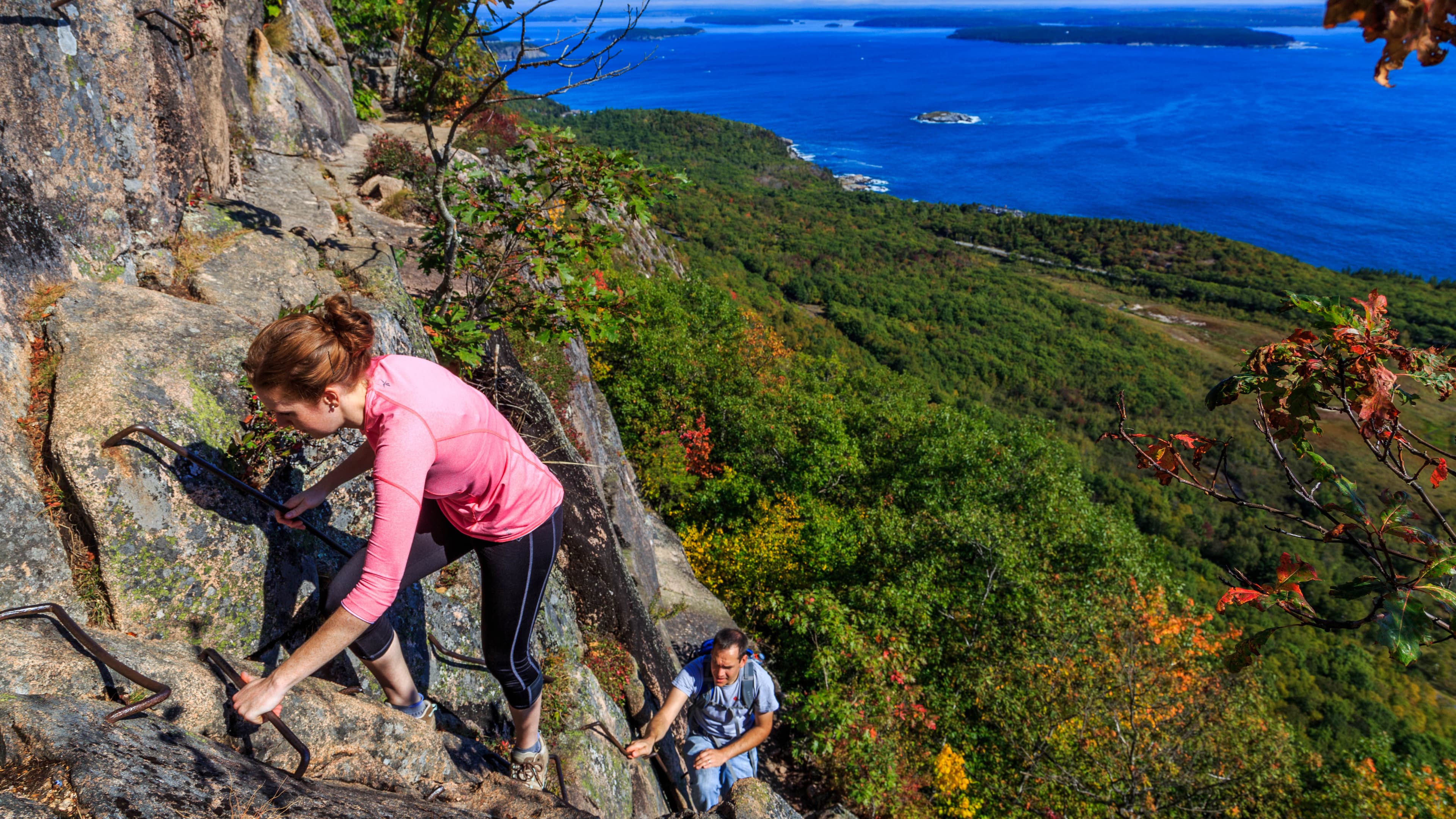
Hike Beehive Loop
This is a 1.4 mile loop trail that ascends a 450 ft cliff face. Exposed cliffs, iron rungs, and granite staircases climb this trail revealing scenic ocean views.
Duration: 1-3 Hours
Hike Bubbles
This short 1.5 mile hike offers views of Jordan Pond and the surrounding mountains from the iconic North Bubble, South Bubble, and Bubble Rock.
Duration: 60-90 Minutes
Hike Bubbles Nubble Loop
This hike traverses the summits of North Bubble, South Bubble, and Connors Nubble and crosses varying terrain of forest paths, steep granite sections, and a level carriage road. Visitors can enjoy views of Eagle Lake, Jordan Pond, Pemetic and Sargent Mountains, and the Cranberry Isles.
Duration: 1-2 Hours
Hike Cadillac North Ridge Trail
A moderate out-and-back hike to the highest point both in Acadia and on the eastern seaboard. The trail is mostly exposed, providing hikers with sweeping vistas of Bar Harbor, Frenchman Bay, and the Schoodic Peninsula.
Duration: 2-4 Hours
Hike Cadillac South Ridge Trail
This out and back trail is the longer option for hiking Cadillac Mountain with spectacular views of the Atlantic Ocean and outlying islands before reaching the summit.
Duration: 2-4 Hours
Hike Carriage Roads
Many carriage roads intersect with hiking trails. They can be incorporated into a hike to create a loop, add distance, or provide opportunities for more even terrain to gain or lose elevation.
Hike Compass Harbor Trail
Explore a historic site near Bar Harbor and enjoy a dramatic shoreline with views of Frenchman Bay and Ironbound Island.
Duration: 30-45 Minutes
Hike Dorr Mountain South Ridge Loop
The Dorr Mountain South Ridge Loop is a 3.2 mile loop featuring views of Mount Desert Island from the top of Dorr Mountain after a steep ascent.
Duration: 1-2 Hours
Hike Double Bubble Nubble Loop with Island Explorer
The trek to summit both Bubbles and Conners Nubble summits three peaks and accesses iconic park locations. Hikers will be treated to views of lakes and mountains while exploring woodlands. By hiking with the use of the Island Explorer Bus, these trails are accessible in a unique way and helps hikers overcome the crowds while exploring popular viewpoints.
Duration: 4-5 Hours
Hike Emery Path
Emery Path is a steep .5 mile memorial path at Sieur de Monts leading up towards Schiff Path and Dorr Mountain.
Duration: 20-45 Minutes
Hike Flying Mountain Loop
This loop hike offers a short, relatively steep hike to the top of a small mountain with spectacular views of Somes Sound and descends to a quiet ocean cove with a rocky beach.
Duration: 1-2 Hours
Hike Giant Slide Loop
A challenging hike up a rugged ravine to excellent views atop Mount Desert Island's second highest peak, Sargent Mountain, and other summits.
Duration: 2-4 Hours
Hike Gorge/Cadillac Mountain North Ridge Loop with Island Explorer Bus
This is a great option for hiking to the summit of Cadillac Mountain. It follows Kebo Brook which cuts deeply through the granite bedrock with views of steep canyons walls from the gorge below. The final portion of the path ascends a steep rock face and gives hikers vistas of Dorr Mountain, Frenchman Bay, the Atlantic Ocean, as well the deeply cut gorge itself. The summit of Cadillac Mountain provides a 360-degree view out over Mount Desert Island.
Duration: 2-4 Hours
Hike Gorge Path
Gorge Path follows a narrow, rocky gorge separating Dorr and Cadillac Mountains. It crosses streams, climbs steep, granite steps, and intersects other trails leading to either summit.
Duration: 2-3 Hours
Hike Gorham Mountain Loop
The Gorham Mountain Loop is 3.5 miles featuring mountains and a rocky coastline with panoramic views of Mount Desert Island, Frenchman Bay, and the outlying islands.
Duration: 1-3 Hours
Hike Great Head Trail
This 1.7 mile trail has spectacular ocean views along a coastal headland with some wooded sections. This historic trail also includes the ruins of an early 1900's tea house.
Duration: 2-4 Hours
Hike Great Head with Island Explorer Bus
Great Head Trial provides visitors a chance to hike a shorter trail and get amazing views of the ocean and forest in the same hike. Enjoy the views while relaxing on the beach afterward.
Duration: 1-2 Hours
Hike Hadlock Ponds Loop
Enjoy boardwalks, wooden bridges and some uneven terrain on this 4.1 mile figure eight trail that includes both Lower and Upper Hadlock Ponds.
Duration: 2-4 Hours
Hike Homans Path
Homans Path is a memorial path at Sieur de Monts. It is a .3 mile steep ascent with impressive examples of intricate rock work. It is one of the routes to reach Schiff Path, and eventually the summit of Dorr Mountain.
Duration: 15-30 Minutes
Hike Jesup Path and Hemlock Path Loop
This forested path continues to a boardwalk with multiple interpretive signs and benches. It opens up to a meadow before looping back on an old fire road. Views of Dorr Mountain are interspersed in this walk along a birch and hemlock forest.
Duration: 30-60 Minutes
Hike Jordan Cliffs Loop
The Jordan Cliffs Loop offers a challenging 5 mile hike across steep slopes, iron rungs, and a strenuous climb up Sargent Mountain. Hikers are rewarded with panoramic views from two mountain summits and Jordan Pond nestled between the mountains.
Duration: 3-4 Hours
Hike Jordan Pond Loop with Island Explorer Bus
If looking for a way to relax, to take in some magnificent views, or to just burn some of the calories from the popovers consumed at the Jordan Pond house, the Jordan Pond Path is a great choice. Even just walking along the eastern shoreline is a certain way to enjoy some scenic vistas of one of Acadia’s iconic locations.
Duration: 1-2 Hours
Hike Jordan Pond Path
The trail follows the shore of Jordan Pond, providing iconic views of steep, glacially sculpted mountains and the glacially carved valley that is now Jordan Pond.
Duration: 1-3 Hours
Hike Kebo Brook Trail to Kebo Mountain
This 2 mile out-and-back trail follows a fairly level forest path before a short, steep climb to reach the summit of Kebo Mountain.
Duration: 1-2 Hours
Hike Kurt Diederichs Climb
Kurt Diederichs Climb is a memorial path at Sieur de Monts. It is a .4 mile steep ascent with many granite steps. It is one of the routes to reach Schiff Path, and eventually the summit of Dorr Mountain.
Duration: 20-30 Minutes
Hike Norumbega Mountain Loop
The Norumbega Loop Trail features a steep hike up to the summit of Norumbega Mountain, then a gradual descent in the forest before hiking along the western shore of Lower Hadlock Pond.
Duration: 2-3 Hours
Hike Ocean Path Trail
The ocean path is a spectacular 2.2 mile long out and back trail takes you along the bold coast of Maine with ocean views, granite slabs, and rocky cliffs. This trail is a great way to access Thunder Hole and Otter Point from the Sand Beach parking area.
Duration: 2-4 Hours
Hike Ocean Path Trail with Island Explorer Bus
Ocean Path follows atop Acadia’s granite cliffs along the Atlantic Ocean. While exploring the Ocean Path, visitors can enjoy scenic vistas and iconic park locations including Sand beach, Thunder Hole and Otter Cliffs. Combining this hike with Acadia’s Island Explorer bus gives hikers flexibility in trail distance on what would otherwise be an out-and-back hike.
Duration: 1-2 Hours
Hike Pemetic Mountain Loop
The Pemetic Mountain Loop combines a variety of hiking environments over 4 miles, starting with an easy walk along a scenic pond to a rugged ascent. It culminates at an open granite summit with excellent views of the surrounding landscape, ocean and outlying islands.
Duration: 2-3 Hours
Hike Pemetic South Ridge
This hike reaches the summit of Pemetic Mountain from Jordan Pond, providing panoramic views of the ocean and surrounding islands.
Duration: 2-3 Hours
Hike Pemetic Summit with Island Explorer Bus
The hike up and over Pemetic takes hikers to the shores of both Bubble and Jordan Pond and summits Pemetic Mountain. Nearly 360-degree views look out over Cadillac, Sargent and Penobscot peaks, the Atlantic Ocean and the Cranberry Isles. Hiking this peak with use of the Island Explorer Bus offers hikers a bus-stop-only starting point for a strenuous hike with minimal mileage.
Duration: 2-4 Hours
Hike Perpendicular and Razorback Loop
The loop features a gravel shoreline path along Long Pond and a steep ascent on granite staircase of over 300 stone steps built by the CCC to reach the summit of Mansell Mountain.
Duration: 1-2 Hours
Hike Precipice Loop
Rising over 1,000 feet in 0.9 miles, the Precipice Trail requires physical and mental strength. It is a rugged, non-technical climb with open cliff faces and iron rungs, and reaches the summit of Champlain Mountain.
Duration: 2-3 Hours
Hike Sargent and Penobscot Mountains from JPH with Island Explorer Bus
The trails up Sargent and Penobscot Mountains are located a short distance from the Jordan Pond House restaurant and gift shop.
Hike Schiff Path
Schiff Path is a popular, relatively steep trail and acts as a connector between Sieur de Monts and the summit of Dorr Mountain. It is one of the memorial trails built between 1924 and 1930.
Duration: 30-60 Minutes
Hike Schoodic Peninsula Trails
This 7.5 mile network of hiking trails leads across the peninsula, from Winter Harbor in the north through spruce-fir forests, pine woodlands, and a shrubland, terminating on the southern end at Blueberry Hill. Enjoy views from the Anvil and Schoodic Head, as well as some challenging steep climbs from the East Trail.
Hike Ship Harbor Trail
Ship Harbor Trail is a 1.3 mile figure-8 loop near Seawall. Great for families and birders, and a variety of habitats can be seen along the shore.
Duration: 30-60 Minutes
Hike Sieur de Monts to Jesup Path with Island Explorer Bus
The trails from Sieur de Monts to Jesup Path are located adjacent to the Nature Center and the Wild Gardens of Acadia in a wooded area.
Duration: 1-2 Hours
Hike Sieur de Monts to Sand Beach Trek with Island Explorer
The trek from Sieur de Monts to Sand Beach connects four trails and summits Champlain Mountain. Hikers will be treated to views of lakes, mountains and ocean while exploring woodlands, ponds and bare summits. By hiking with the use of the Island Explorer Bus, these trails are transformed from out-and-back hikes to a scenic trek across Acadia National Park.
Duration: 2-4 Hours
Hike St. Sauveur and Acadia Mountain Loop
This 3.9 mile challenging loop summits two mountain peaks and offers stunning views of Somes Sound, the surrounding mountains, outlying islands,and the ocean.
Duration: 2-4 Hours
Hike the Acadia Mountain Loop with Island Explorer Bus
Acadia Mountain Trail follows up the east and west side of the mountain with views of the surrounding mountains and bodies of water. With the Island Explorer bus, visitors won't need to park along the road and can ride to the trailhead stress-free.
Duration: 2-3 Hours
Hike Village Green to Sieur de Monts with Island Explorer Bus
Beginning at the Village Green in Bar Harbor and ending at the Sieur de Mont Area this hike includes the Great Meadow Loop, the Hemlock Road Trail, and the Jesup Path. With virtually no elevation gain it traverses a Bar Harbor neighborhood, crosses the Great Meadow, and finishes with a boardwalk at the Nature Center.
Duration: 1-1 Hours
Hike Western Mountain Loop
This 3.8 mile loop travels through forested areas and up the summits of Bernard Mountain and Mansell Mountain, together creating Western Mountain. Although there are not many views, it is a challenging hike with hundreds of cut stone steps and other steep sections along the way.
Duration: 2-3 Hours
Hike Wonderland Trail
This 1.4 out and back trail on an old gravel fire road is family-friendly and provides direct access to the coastline with birding opportunities.
Duration: 30-60 Minutes
Oldfarm Video Tour
George B. Dorr worked tirelessly through the early 1900s to found what we know today as Acadia National Park. His former family estate, known as Oldfarm, is situated along the Compass Harbor Trail, less than a mile from downtown Bar Harbor on State Route 3. The short walk beneath forest canopies leads to foundation remnants of his former cottage, demolished in 1949, and ends at Dorr Point with views of Compass Harbor and the Porcupine Islands.
Paddle Eagle Lake
Explore Eagle Lake by canoe or kayak.
Paddle Echo Lake
Launch at Ikes Point to explore Echo Lake by boat.
Paddle Jordan Pond
Paddle Jordan Pond in the center of Mount Desert Island.
Paddle Long Pond
Explore Acadia's longest pond by boat.
Picnic at Jordan Pond
Eat at Acadia's only restaurant, the historic Jordan Pond House, or bring your own picnic. This popular spot on Park Loop Road is a crossroad for historic carriage roads and hiking trails, as well as a launch point for canoeing and kayaking.
Stargazing at Jordan Pond
Find opportunities to stargaze and photograph the night sky the shores surrounding Jordan Pond.
Stargazing at Sand Beach
Enjoy stargazing and night photography opportunities from Acadia’s only sandy beach.
Stargazing at Seawall
Explore the night sky from the west side of Mount Desert Island while enjoying the ocean soundscape.
Stargazing Ocean Path
Learn about stargazing opportunities along the coast on Ocean Path.
Stargazing on Cadillac Mountain (Vehicle Access Limited)
Gaze in awe at Acadia's night sky from the highest mountain summit in the park.
Swim Echo Lake Beach
Echo Lake Beach is a popular, freshwater swimming area on the southern end of Echo Lake. It is accessible off Route 102 in Southwest Harbor.
Swim Lake Wood
Lake Wood is a secluded pond with a small beach area, just a short drive away from Hulls Cove Visitor Center. There are no lifeguards and access road does not open until June 1.
Swim Sand Beach
Acadia’s only sandy ocean beach, at the beginning of the Park Loop Road’s coastal section, is one of the park’s most heavily-visited areas. Visitors come to swim in the frigid water, bask and play on the sand, seek intertidal creatures, or view a feature widely publicized as a “must-see.”
Tidepooling at Bar Island
Access the shore from downtown Bar Harbor for a unique tidepooling experience on a natural land bridge.
Duration: 30-60 Minutes
Tidepooling at Ship Harbor
Explore tidepooling opportunities on the rocky shoreline off this easy figure-8 coastal forest trail.
Tidepooling at the Schoodic Peninsula
Tidepooling locations at the Schoodic Peninsula.
Tidepooling at Wonderland
Explore rocky tidepools at the far end of this coastal forest trail on the west side of Mount Desert Island.
Tour de Wildlife
A few spots with great potential for wildlife viewing, and what you might find there.
Visitor centers
Acadia Gateway Center
The Acadia Gateway Center is an intermodal transit and welcome center located on Route 3 in Trenton three miles north of Mount Desert Island. Facilities include an Island Explorer bus stop, day-use parking, and an 11,000-square-foot welcome center with tourism information, a store, waiting area, and restrooms. Owned by the State of Maine, it is operated by the Maine Department of Transportation in partnership with the National Park Service, Downeast Transportation Inc., and Maine Office of Tourism.
Get directionsHulls Cove Visitor Center
Located close to Bar Harbor off Route 3, the Hulls Cove Visitor Center is Acadia’s main visitor contact station and transportation hub from May into October. It is a popular, and often crowded, first stop for many visitors. It is adjacent to an entrance for the park's iconic 27-mile Park Loop Road and it serves as a key stop for several routes on the fare-free Island Explorer bus system. From a large parking lot, visitors must climb 52 steps to the main entrance. There is a separate accessible entrance.
Get directionsIslesford Historical Museum
The Islesford Historical Museum is expected to reopen in 2021 showcasing both the upgrades and a community-curated exhibit helping to tell the stories of the Cranberry Isles.
Get directionsSchoodic Institute Welcome Center at Rockefeller Hall
The Schoodic Institute Welcome Center at Rockefeller Hall is located on Schoodic Peninsula off the one-way loop road. Exhibits about the old Navy base and park information can be found here.
Get directionsSieur de Monts Nature Center
Sieur de Monts Nature Center has visitor services, hiking information, and interactive exhibits. It acts as a trailhead for many hiking trails starting in the Sieur de Monts area. Park rangers are present during the spring, summer, and fall months.
Get directionsWinter Information: Bar Harbor Chamber of Commerce
During winter and spring, information and sales of some passes are available at the Bar Harbor Chamber of Commerce, 2 Cottage Street, at the corner of Cottage and Main streets (GPS coordinates = 44.398633, -68.204933). The center is open 7 days a week from 8 am to 4 pm. There will be full-day holiday closures on Thanksgiving, Christmas Eve, Christmas Day, New Year's Eve, and New Year's Day.
Get directions
Webcams
Acadia Air Quality Cam
Currently unavailable.
Eye on Acadia
Currently unavailable.
Jordan Pond Webcam
Currently unavailable.
Hours of operation
Acadia National Park
Acadia National Park is open year-round. Check our website for park facilities operating hours, such as Hulls Cove Visitor Center.
Mon
All Day
Tue
All Day
Wed
All Day
Thu
All Day
Fri
All Day
Sat
All Day
Sun
All Day
Activities
Weather
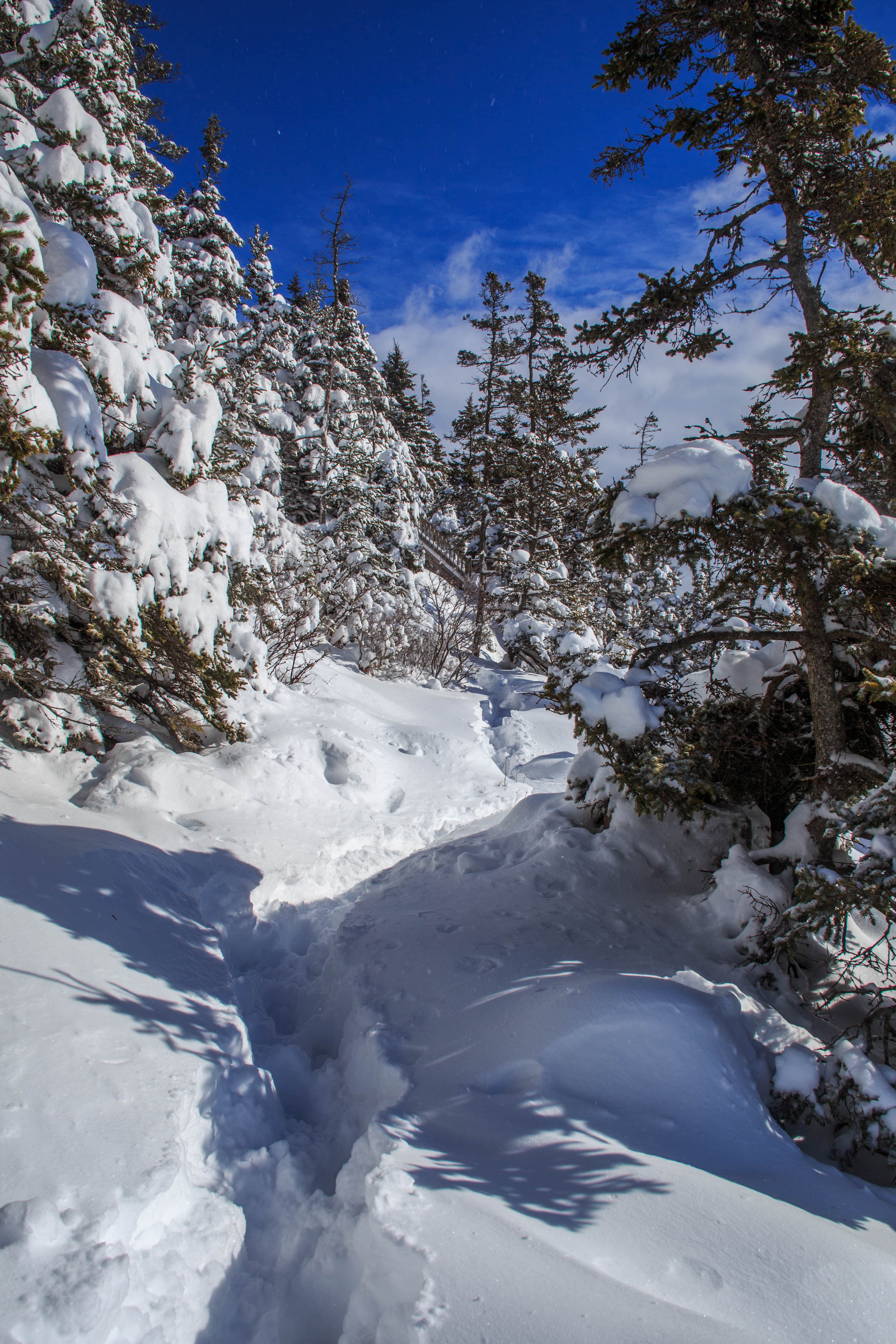
Located on Mount Desert Island in Maine, Acadia experiences all four seasons. Summer temperatures range from 45-90F (7-30C). Fall temperatures range from 30-70F (-1-21C). Typically the first frost is in mid-October and first snowfall begins in November and can continue through April with an average accumulation of 73 inches (185 cm). Winter temperatures range from 14-35F (-10 - 2C). Spring temperatures range from 30-70F (-1-21C).
Contact
Photos
Stay near this park
No horse-friendly stays listed near Acadia National Park yet. Know a great barn or property? Help fellow riders by listing it.
List your propertyDirections
From Boston take I-95 north to Augusta, Maine, then Route 3 east to Ellsworth, and on to Mount Desert Island. For an alternate route, continue on I-95 north to Bangor, Maine, then take I-395 to U.S. Route 1A east to Ellsworth. In Ellsworth, take Route 3 to Mount Desert Island.
Source: nps.gov