
Caution
Wildfire Smoke Impacts
Smoke from the Babylon Fire near Blanding, UT is impacting the park's air quality. Check Utah Fire Info for wildfire information and the link for current air quality in Moab.
More infoCaution
No Wood or Charcoal Fires Allowed - Stage 2 Fire Restrictions in Effect
All fires are prohibited. Only petroleum or propane-fueled stoves or grills are allowed in backcountry campsites, campgrounds, and picnic areas. Fireworks are never allowed. Smoke only inside vehicles or in developed areas over 3 feet from flammables.
More infoInformation
Trip-planning tips for 2026
Planning to visit Arches this year? To ensure the best experience, please anticipate potentially long wait times at the entrance station. If trailhead parking is full, plan to return a little later. Please avoid parking on vegetation and roadways to help preserve this beautiful place for everyone to enjoy.
Arches National Park
UT · Moab
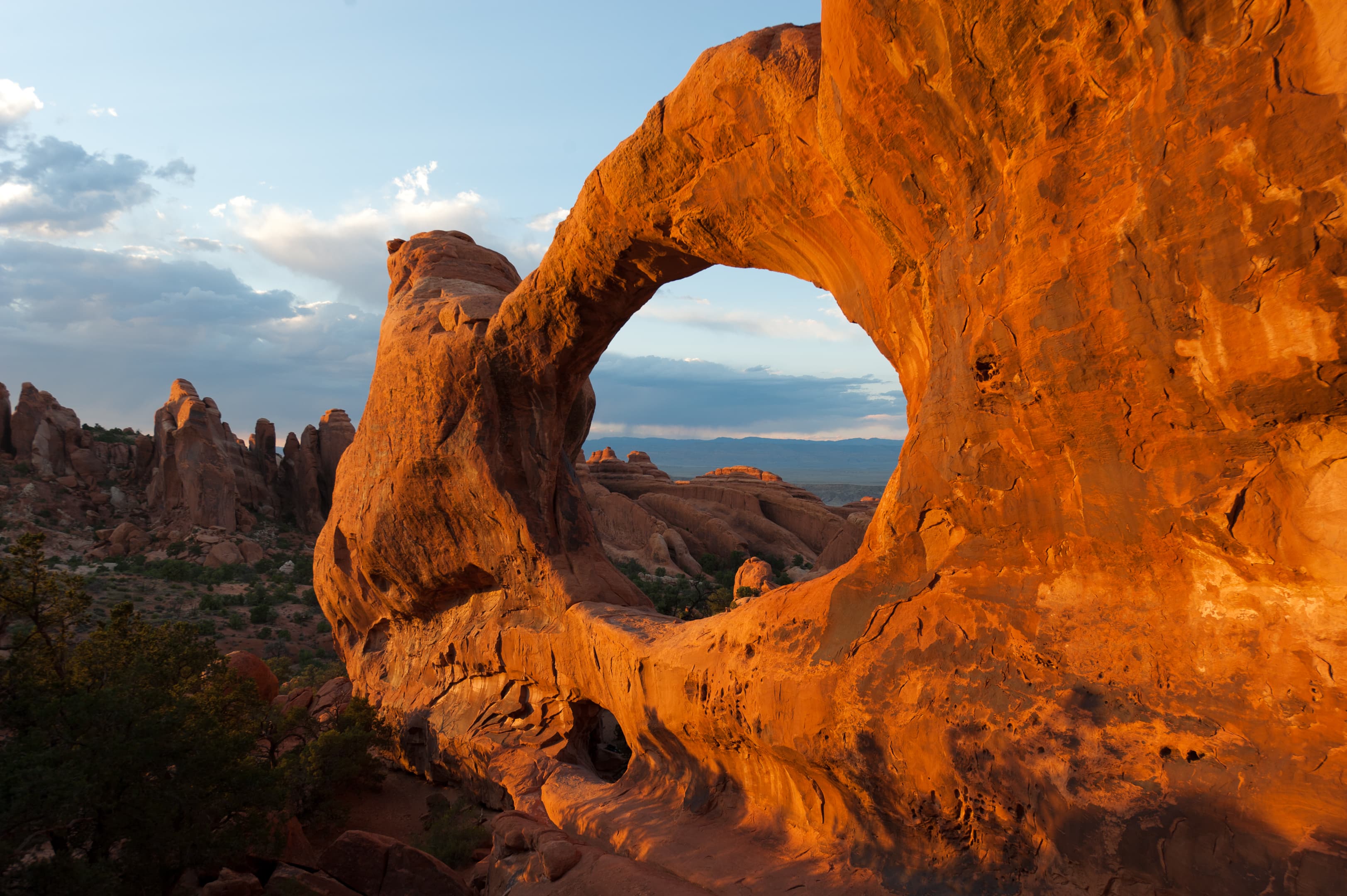
Discover a landscape of contrasting colors, land forms, and textures unlike any other. The park has over 2,000 natural stone arches, hundreds of soaring pinnacles, massive rock fins, and giant balanced rocks. This red-rock wonderland will amaze you with its formations, refresh you with its trails, and inspire you with its sunsets.
Riding guide
Highlights
Discover a landscape of contrasting colors, land forms, and textures unlike any other.
Riding
Rideable terrain here is noted as 18 miles, giving riders a clearer sense of scale before they ever unload. Discover a landscape of contrasting colors, land forms, and textures unlike any other. The park has over 2,000 natural stone arches, hundreds of soaring pinnacles, massive rock fins, and giant balanced rocks. This red-rock wonderland will amaze you with its formations, refresh you with its trails, and inspire you with its sunsets.
Rideable terrain
18 miles
Trailer parking
Willow Springs Road This is generally considered the best staging area for riders bringing their own horses into Arches. Why it works well: Large open dirt areas suitable for truck and trailer parking Direct access to Willow Springs Road, one of the main stock-permitted routes Less congestion than the main park roads Good views of formations like Tower Arch and the Klondike Bluffs area This road provides some of the longest continuous riding routes in the park. Klondike Bluffs Road Why riders use it: Access to remote northern sections of the park Large dirt staging areas along the road Connects to backcountry routes where horses are allowed Salt Valley Road Benefits: Wide primitive road with places to stage trailers Access to scenic desert riding routes through sandstone fins and open valley terrain
Horse regulations
Arches National Park protects one of the most iconic desert landscapes in the American Southwest. Located just outside Moab, Utah, the park is home to more than 2,000 natural sandstone arches along with towering fins, balanced rocks, and expansive red rock plateaus sculpted by millions of years of erosion. While many visitors experience the park from scenic overlooks and short hiking trails, equestrians who bring their own horses can explore quieter backcountry areas that reveal a very different side of Arches. Horseback riding in Arches takes place primarily on designated backcountry roads that wind through open desert valleys and along the base of towering sandstone formations. Routes such as Willow Springs Road and Salt Valley Road provide riders with access to remote sections of the park where dramatic red rock fins rise above wide desert basins. From horseback, riders can travel through sweeping desert terrain with views of formations like Tower Arch and the Klondike Bluffs while experiencing the stillness of the high desert landscape. The riding terrain in Arches is distinctly desert in character. Trails follow primitive dirt roads across sandy soils, slickrock shelves, and dry washes surrounded by juniper and pinyon pine. Unlike many forested national parks, shade is limited and the landscape is wide open, making early morning or cooler-season rides especially enjoyable. The dramatic contrast between deep red sandstone and bright blue desert sky creates an unforgettable riding backdrop. Although the equestrian network in Arches is smaller than in many western parks, riders who venture into these backcountry routes experience a quieter and more expansive perspective of the park. For equestrians seeking classic red rock scenery, vast desert views, and the unique geology of the Colorado Plateau, Arches National Park offers a memorable and distinctly Southwestern riding experience.
Getting here
Use 573 N. HWY 191, Moab, Utah as your primary planning reference before you haul in. Willow Springs Road This is generally considered the best staging area for riders bringing their own horses into Arches. Why it works well: Large open dirt areas suitable for truck and trailer parking Direct access to Willow Springs Road, one of the main stock-permitted routes Less congestion than the main park roads Good views of formations like Tower Arch and the Klondike Bluffs area This road provides some of the longest continuous riding routes in the park. Klondike Bluffs Road Why riders use it: Access to remote northern sections of the park Large dirt staging areas along the road Connects to backcountry routes where horses are allowed Salt Valley Road Benefits: Wide primitive road with places to stage trailers Access to scenic desert riding routes through sandstone fins and open valley terrain
Planning your visit
Riding Is Limited to Designated Backcountry Roads Horseback riding is not allowed on most hiking trails in the park. Instead, riders must remain on approved backcountry routes such as: Willow Springs Road Salt Valley Road Klondike Bluffs routes Tower Arch area roads Traveling off these routes can damage delicate desert soils and vegetation. Desert Soils Are Extremely Fragile Much of the park contains cryptobiotic soil crust, a living ecosystem that stabilizes desert soil and prevents erosion. This crust can be permanently damaged by hooves. To protect the landscape: Stay on established roads and routes Do not cross undisturbed desert areas Avoid riding after heavy rain when soils are soft Limited Facilities for Horses Arches does not have developed horse facilities, corrals, or equestrian campgrounds. Riders should plan for: No water sources for horses No hitching rails or stock facilities Primitive roadside staging areas All feed, water, and equipment must be brought into the park. Extreme Desert Conditions The park sits in a high desert environment where conditions can change quickly. Riders should be prepared for: Summer temperatures exceeding 100°F (38°C) Limited shade across most routes Rapid dehydration for both horses and riders Spring and fall are generally the most comfortable seasons for riding. Wildlife and Landscape Awareness Although Arches is a desert park, wildlife such as desert bighorn sheep, coyotes, and mule deer live in the area. Riders should maintain distance from wildlife and remain aware of narrow backcountry roads where four-wheel-drive vehicles may also travel.
Where to stay
Arches National Park Visitor Center is the main visitor-contact point tied to this destination, which is helpful when you want current conditions, maps, and stock-use updates before riding. This entry reads best as a bring-your-own-horse destination rather than a horse-rental stop, and amenities should be confirmed directly before travel. For a polished trip plan, pair the ride with lodging, fuel, and resupply planning in or near Moab before heading deeper into federal-land access points.
Entrance fees & passes
- $30.00
Entrance - Private Vehicle
Admits one private, non-commercial vehicle (15 passenger capacity or less) and all its occupants.
- $25.00
Entrance - Motorcycle
Valid for 7 days. Admits up to 2 private, non-commercial motorcycles with up to 4 total passengers.
- $15.00
Entrance - Per Person
Admits one individual with no car. Typically used for bicyclists, hikers, and pedestrians. Youth 15 and under are admitted free.
- $55.00
Annual Entrance - Park
Valid for one year through the month of purchase. Admits one (1) private, non-commercial vehicle or its pass holder to Arches and Canyonlands national parks, and Natural Bridges and Hovenweep national monuments. U.S. residents only.
Park map
Trails
No trails synced for this park yet.
Campgrounds
Devils Garden Campground
51 sites
Camp among slickrock outcroppings at Devils Garden Campground, 18 miles from the park entrance. Facilities include drinking water, picnic tables, grills, and both pit-style and flush toilets. You can reserve standard campsites up to 6 months in advance for stays March 1-October 31. All sites are usually reserved months in advance. Between November 1 and February 28, sites are first-come, first-served. Winter campers are encouraged to download the Recreation.gov app **before arriving** to use for payment.
Reserve a site
Points of interest
Arches Entrance Station
POIArches Entrance Station
Arches Visitor Center Exterior Zone 1
POIAudio description of Arches Visitor Center Zone 1- Water Filling Station
Arches Visitor Center Exterior Zone 10
POIArches Visitor Center Exterior Zone 2
POIFeatured outside of the Arches National Park Visitor Center
Arches Visitor Center Exterior Zone 3
POIArches Visitor Center Exterior Zone 4
POIArches Visitor Center Exterior Zone 5
POIArches Visitor Center Exterior Zone 7
POIArches Visitor Center Exterior Zone 8
POIArches Visitor Center Exterior Zone 9
POIArches Visitor Center Nature Trail
POIWalk a short path behind the visitor center to learn about native desert plants and their traditional uses. Roundtrip Distance: 150 feet (45 m) Time: 10 min Elevation Change: 0 ft (0 m)
Balanced Rock Viewpoint and Trail
POIBalanced Rock is visible from the park road. Although parking is limited, many visitors stop to complete the short hike around the feature's base for unusual and up-close perspectives. This loop trail is partly paved and may be accessible to wheelchairs. Climbing on Balanced Rock is prohibited. Roundtrip Distance: 0.3 mi (0.4 km) Time: 15-30 min Elevation Change: 35 ft (11 m)
Broken Arch Trail
POIFrom the trailhead at the Sand Dune Arch parking area, the trail crosses a large meadow to Broken Arch. You can return from there or continue through the arch to the campground, then circle back through fins with sand dunes and some moderate scrambling. Roundtrip Distance: 1.2 mi (1.9 km) Time: 30-60 minutes Elevation Change: 59 ft (18 m)
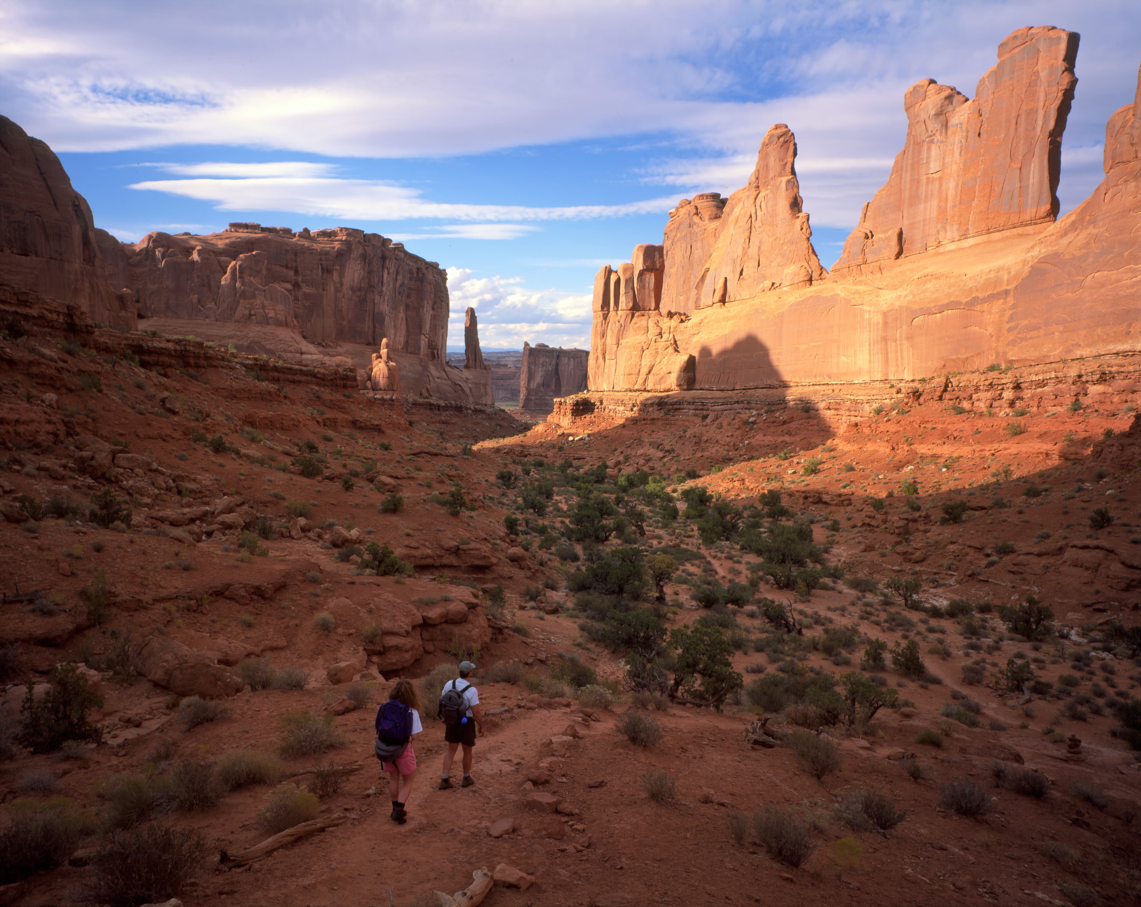
Courthouse Towers Viewpoint and Trailhead
POIThis is the north end of the Park Avenue Trail, which traces a mostly smooth canyon bottom uphill, then ascends rock-cut stairs to Park Avenue Viewpoint. For an easier walk, turn around at the base of the stairs. Roundtrip hikers: please remain on the trail both directions rather than walking along the road. Roundtrip Distance: 1.8 mi (3.2 km) Time: 1 hour Elevation Change: 322 ft (98 m) -- or much less if you skip the stairs
Courthouse Wash Panel Trail
POIA rock markings panel above the Colorado River offers insight into the lives and movements of archaic peoples. View the panel from below (better with binoculars) or hike a short trail up to its base. First part of trail is paved and accessible to wheelchairs. Roundtrip Distance: 0.8 mi (1.4 km) Time: 30-60 min Elevation Change: 60 ft (18 m)
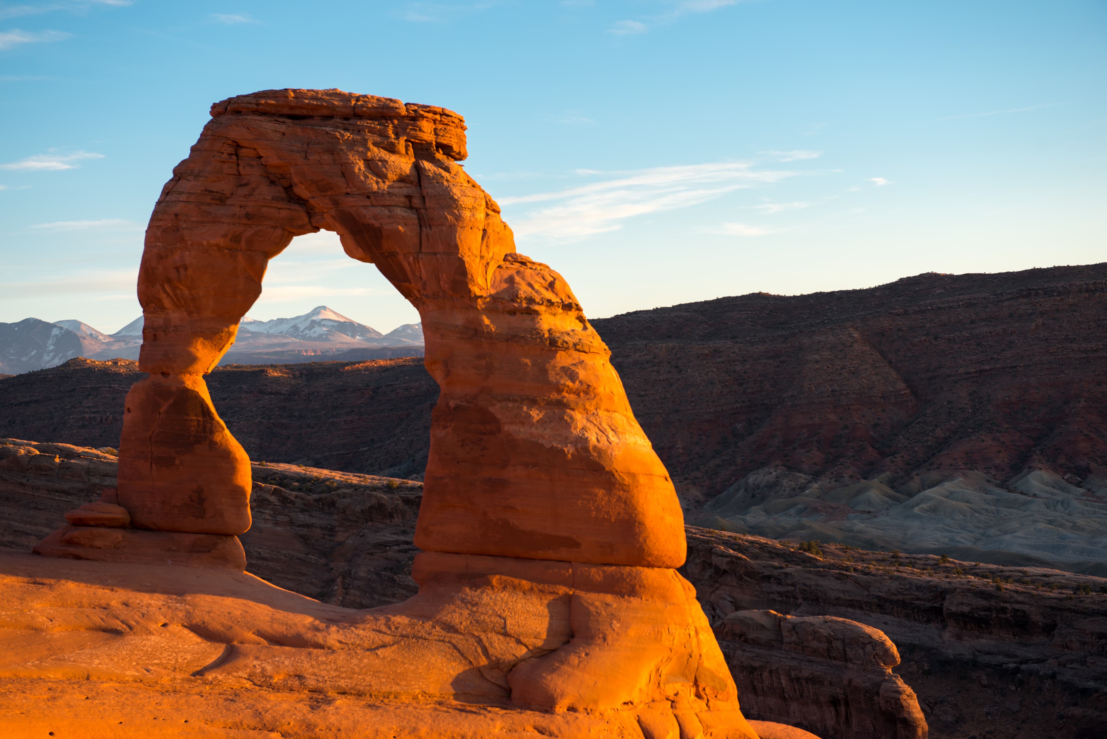
Delicate Arch Trail
POIThis trail hikes up 538 feet (164 m) to the most famous arch in the park, crossing open slickrock with no shade. Pass historic Wolfe Ranch and a rock markings panel, then climb steadily; follow the rock cairns and signs. Just before you get to Delicate Arch, the trail traverses a narrow rock ledge for about 200 yards (183 m). Take at least 2 quarts (2 L) of water per person. Roundtrip distance: 3 miles (4.8 km) Time: 2-3 hours
Delicate Arch Viewpoint Trails
POISee the most famous arch in the park at a distance from one of these viewpoints. Lower Viewpoint is level and wheelchair-accessible; with a roundtrip distance of 200 ft (61 m). Upper Viewpoint is moderately strenuous: Roundtrip Distance: 0.5 mi (0.8 km) Time: 30-45 min Elevation Change: 171 ft (52 m)
Devils Garden Trail
POIThis trailhead offers a range of hikes, from short to strenuous. Beyond Landscape Arch (listed above), the trail climbs sandstone slabs. Footing is rocky, with narrow ledges, exposure to heights, rock scrambling, and few trail markers. Avoid when rock is wet or snowy. Bring at least 3 quarts (3 L) of water per person. Roundtrip just to Double O Arch: 4.0 miles (6.4 km), 2-3 hours. Whole Trail: 7.9 miles (12.7 km), 3-5 hours
Double Arch Viewpoint and Trail
POIThe tallest arch in the park at 122 ft (34 m), Double Arch is visible from The Windows parking loop. A relatively flat, gravel-surfaced path leads to the base of its two huge, arching spans. May be accessible to wheelchairs with some assistance. Roundtrip Distance: 0.6 mi (1 km) Time: 15-30 min Elevation Change: 30 ft (10 m)
Fiery Furnace Viewpoint and Permit Area
POIThe Fiery Furnace is a labyrinth of narrow sandstone canyons that requires agility to explore. One route is marked, but getting lost is still possible. Entering the Fiery Furnace requires tickets for a ranger-led hike or permits for exploring on your own. Both must be reserved in advance through Recreation.gov.
Landscape Arch Trail
POIA hard-packed trail leads to a spectacular ribbon of rock, whose span is longer than 300 feet (91 m). Spur trails lead to Pine Tree Arch and Tunnel Arch. Steep slopes may be accessible to wheelchairs with assistance. After Landscape Arch, the Devils Garden Trail becomes difficult, with rock scrambling, narrow ledges, and exposure to heights. Roundtrip Distance: 1.8 mi (2.9 km) Time: 30-60 min Elevation Change: 40 ft (12 m)
La Sal Mountains Viewpoint
POILa Sal Mountains Viewpoint is located a short distance inside the park and offers an excellent overview of red rock scenery both inside and outside the park.
Moab Fault Viewpoint
POIThe highway below Arches parallels an ancient geologic fracture line, called the Moab Fault.
Panorama Point Viewing Area
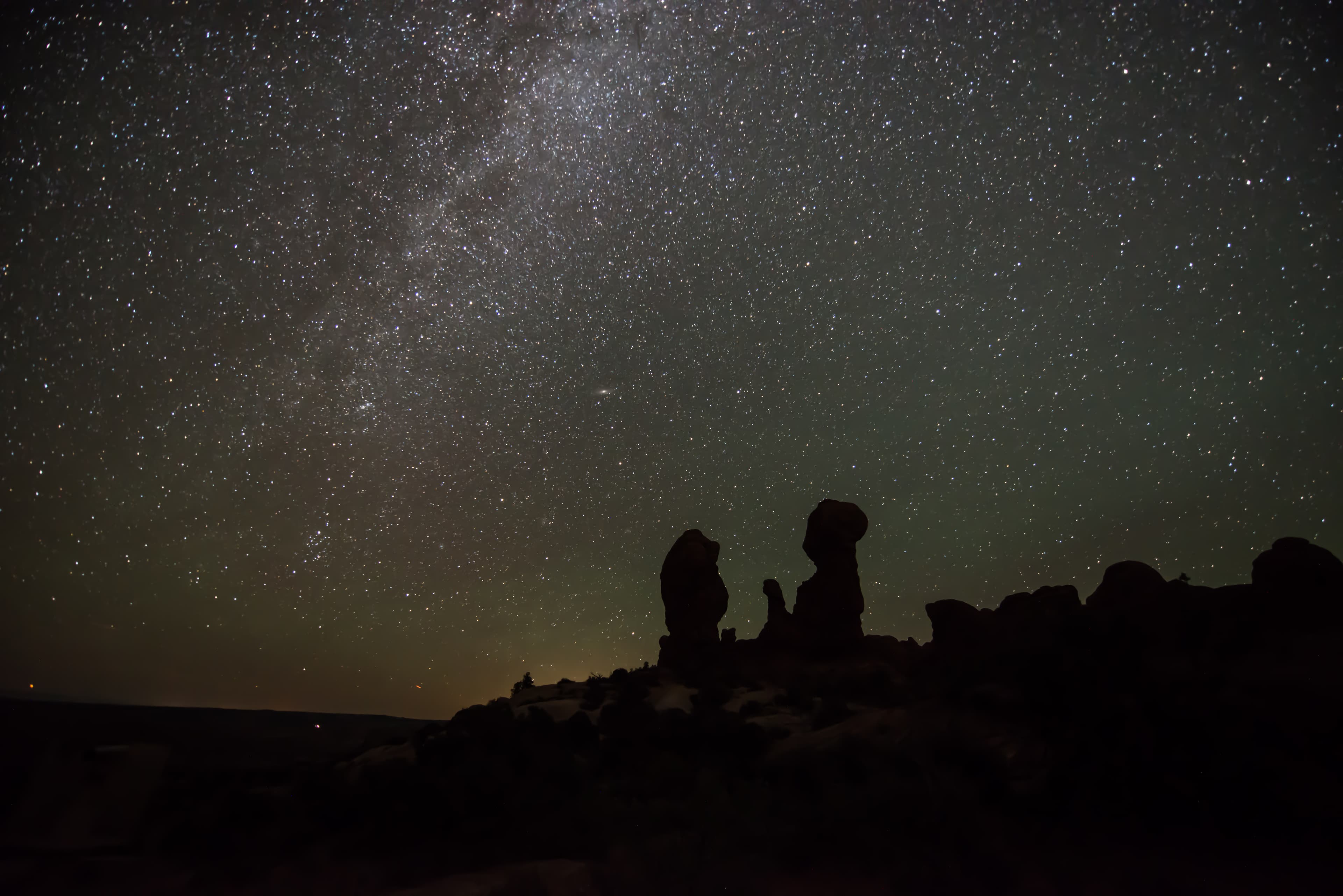
POIPanorama Point offers wide-open views of Arches and the surrounding area. Located at the top of a hill, you can enjoy views of the La Sal Mountains, the Fiery Furnace, and even Devils Garden from your vehicle or at viewpoints along the parking area. Panorama Point is also an excellent place to stargaze and take in the night sky.
Park Avenue Viewpoint and Trail
POIA paved sidewalk (wheelchair accessible) leads to a viewpoint down a corridor of towering rock walls and spires. Descend stairs to walk the trail among massive monoliths toward Courthouse Towers Viewpoint. For a roundtrip hike, return along the trail rather than walking along the road. Roundtrip Distance: 1.8 mi (3.2 km) Time: 1 hour Elevation Change: 322 ft (98 m)
Pets in Arches
POIPets and owners have a special bond, but a national park is not always the best place for pets. Arches National Park is a designated natural area, and its purpose is to preserve and protect the park's natural environment, cultural resources, wildlife, and scenic beauty. When in Arches, it is your responsibility to know and adhere to all rules and regulations regarding pets in the park.
Sand Dune Arch Trail
POIHike through deep sand to find this hidden arch between tall sandstone walls. You may also choose to continue across a grassland to Broken Arch, returning via the same trail or making a loop through the campground. Roundtrip Distance: 0.4 mi (0.6 km) Time: 15-30 min Elevation Change: 0 ft (0 m)
Skyline Arch Trail
POIA short, out-and-back hike on well defined trail leads to an arch in a high wall. On a cold night in November 1940, a large chunk fell out of this arch, instantly doubling the size of its opening. Roundtrip Distance: 0.4 mi (0.6 km) Time: 10-20 min Elevation Change: 28 ft (8 m)
The Windows Viewpoint and Trail
POIMassive North Window is visible from the parking lot. A gentle climb up a hard-packed trail and stone steps leads to North Window, South Window, and Turret Arch. Return to the parking lot via the same trail, or take the slightly longer primitive route around the back side. First 300 feet (91 m) of main trail may be accessible to wheelchairs with assistance. Roundtrip Distance: 1 mi (1.6 km) Time: 30-60 min Elevation Change: 99 ft (30 m)
Tower Arch Trail
POIThis trail climbs up a rock wall, cuts across a valley, and then meanders through sandstone fins and sand dunes. Reaching this trailhead requires driving 8 mi (14 km) on unpaved roads, which wash out quickly in rainstorms. Roundtrip Distance: 2.6 mi (4.2 km) Time: 2-3 hours Elevation Change: 290 ft (89 m)
Wolfe Ranch
POIThis humble, one-room cabin sits near the present-day trailhead for the hike to Delicate Arch. Visitors regularly peer through the doorway and wonder aloud, "Who lived here... and how?... And why?" For more than a decade, John Wesley Wolfe and his family lived and worked on the remote "Bar DX" ranch, eventually grazing more than 1,000 head of cattle on native grasses that once covered this area.
Things to do
Arches Junior Ranger Program
Filled with fun activities, free Arches Junior Ranger books reveal the wonders of Arches to kids and parents alike.
Backpacking at Arches
Backpacking at Arches is allowed in designated sites only and requires a permit.
Canyoneering at Arches
Arches has no real "slot canyons" but does afford some unique on-rope opportunities.
Enjoy Arches from the Road
If you pay close attention, you can see close to two dozen arches from the comfort of your car.
Duration: 2-4 Hours
Explore the Fiery Furnace
Entry to the Fiery Furnace is managed by permits and ranger-led tours to ensure the experience of solitude and wilderness.
Hiking at Arches
Arches contains a variety of hiking trails, from easy/moderate to long and strenuous. Many trails use cairns (stacks of rocks) for markers and cross broad rock surfaces, requiring attention to follow. Learn how to Protect Yourself and Protect Your Park with hiking safety and Leave No Trace tips.
Rock Climbing at Arches
Most climbing routes in the park require advanced techniques. Climbing is not allowed on any arches or certain named features, such as Balanced Rock.
Stargaze at Panorama Point
Arches National Park and the surrounding Colorado Plateau offer some of the darkest night skies remaining in the United States. You can enjoy the park after dark by viewing spectacular night skies.
Duration: 15-120 Minutes
Stargazing Events in Southeast Utah
Rangers occasionally lead stargazing programs and events at parks throughout southeast Utah. Learn about what to expect and check out a schedule of stargazing events at Arches and Canyonlands national parks and Hovenweep and Natural Bridges national monuments. Even when formal programs are not offered, people are welcome to enjoy the parks after dark on their own.
Duration: 1-3 Hours
Start at Arches Visitor Center
Stop at the visitor center to plan your visit, fill your water bottle, learn about the park, and pick up a souvenir.
Duration: 15-60 Minutes
Visitor centers
Arches Visitor Center
The visitor center is generally open every day except December 25. Hours vary by season. You can learn about the park from exhibits and a bookstore. Rangers are on duty to answer your questions. Restrooms and drinking water are available.
Get directions
Webcams
Entrance Station Webcam
Currently unavailable.
UDOT Traffic Camera
Currently unavailable.
Hours of operation
Park Hours
Arches National Park is generally open 24 hours a day, year-round. Fees apply. The park is very busy between March and October. To avoid traffic, we recommend entering the park before 8 am or after 3 pm.
Mon
All Day
Tue
All Day
Wed
All Day
Thu
All Day
Fri
All Day
Sat
All Day
Sun
All Day
Activities
Weather
Arches is part of the Colorado Plateau, a "high desert" region that experiences wide temperature fluctuations, sometimes over 40 degrees in a single day. The temperate (and most popular) seasons are spring (April-May) and fall (mid-September-October), when daytime highs average 60 to 80 F and lows average 30 to 50 F. Summer temperatures often exceed 100 F, making strenuous exercise difficult. Winters are cold, with highs averaging 30 to 50 F, and lows averaging 0 to 20 F.
Contact
Photos
Stay near this park
No horse-friendly stays listed near Arches National Park yet. Know a great barn or property? Help fellow riders by listing it.
List your propertyDirections
Arches National Park is located in southeast Utah, five miles north of Moab on US 191. From Moab, Utah, drive five miles north on Main Street/US 191. Turn right at the stoplight. From Interstate 70, take exit 182 (Crescent Junction), then drive south 28 miles on US 191. Turn left at the stoplight.
Source: nps.gov