
California National Historic Trail
CA · CO · ID · KS · MO · NE · NV · OR · UT · WY · Elko
Follow in the footsteps of over 250,000 emigrants who traveled to the gold fields and rich farmlands of California during the 1840s and 1850s: the greatest mass migration in American history. The California National Historic Trail is over 5,000 miles long and covers portions of 10 states. Step into history along more than 1,000 miles of ruts and traces from travelers and their overland wagons.
Riding guide
Horses provided
Highlights
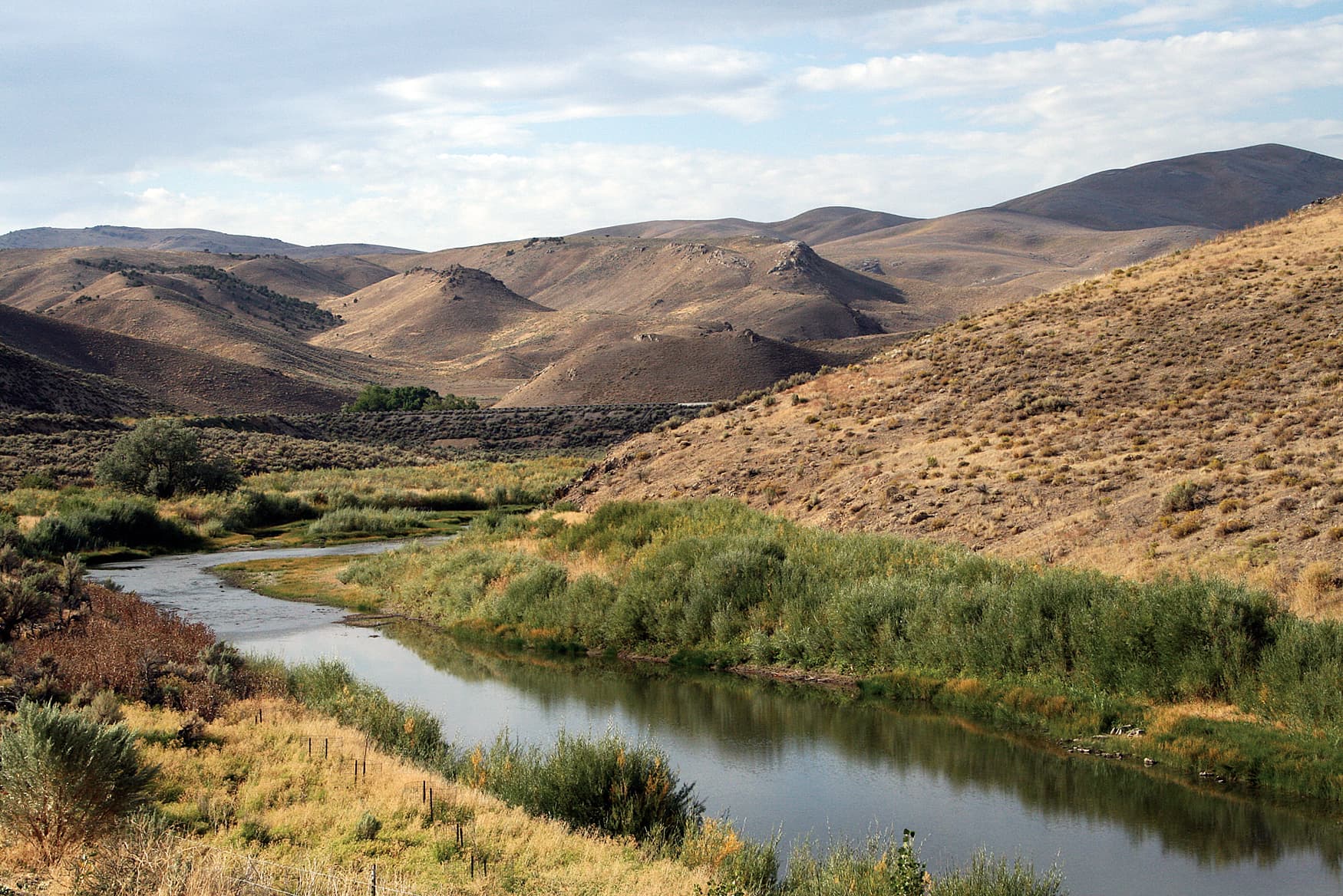
The California National Historic Trail traces one of the most legendary overland migration routes in American history.
Riding
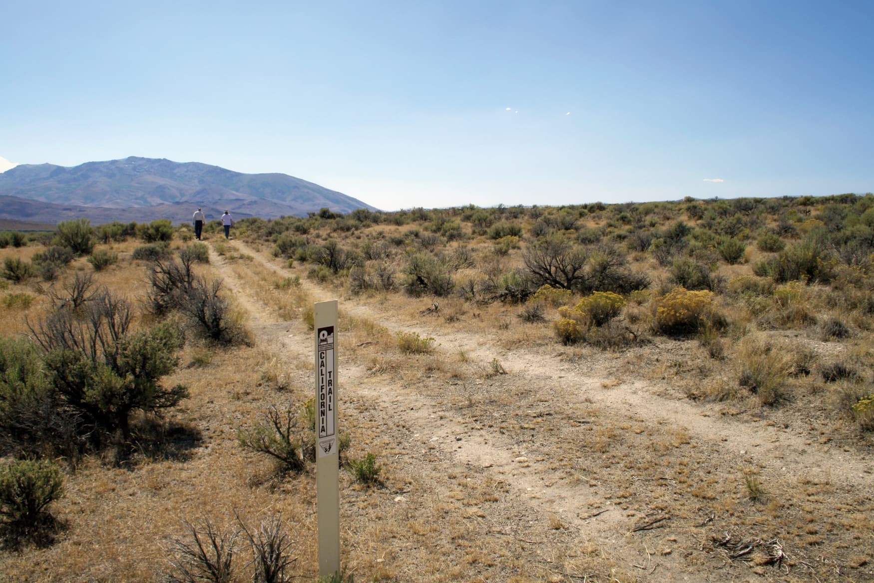
Rideable terrain here is noted as 2,000 miles, giving riders a clearer sense of scale before they ever unload. For equestrians, the California Trail offers a uniquely historic riding experience. Rather than a single continuous path, the trail survives in preserved segments scattered across multiple states, many of them crossing open public lands managed by the Bureau of Land Management and U.S. Forest Service. Riders can still follow portions of the original emigrant route where wagon ruts remain visible in the earth, winding across sagebrush plains, desert basins, and mountain passes.
Rideable terrain
2,000 miles
Trailer parking
Mormon Trail Center at Historic Winter Quarters One of the most historically important starting areas along the trail. Why riders stage here Large parking areas nearby Historic interpretive center and trail markers Access to trail segments along the Missouri River corridor Alcova Reservoir / Independence Rock A classic staging area in the Wyoming section of the trail. Why riders use it Large open BLM land suitable for trailers Access to preserved wagon ruts near Independence Rock Long stretches of rideable historic corridor City of Rocks National Reserve One of the most popular horseback riding locations along the trail. Benefits Established equestrian parking areas Primitive horse camps Access to preserved trail sections used by emigrant wagon trains Fort Churchill State Historic Park Important Nevada trail segment. Why riders use it Large staging areas Rideable desert routes following the historic corridor Access to preserved Pony Express and emigrant trail sections Donner Memorial State Park One of the final historic locations on the trail. Why riders stage here Access to preserved Sierra Nevada emigrant trail segments Horse trailer parking in nearby trailheads and forest roads Entry into historic routes crossing the Sierra
Horse regulations
Horse Use Regulations Because the California National Historic Trail spans more than 2,000 Miles and crosses lands managed by many different agencies, there is no single universal rulebook for horseback riders. Regulations vary depending on whether a specific segment is managed by the National Park Service, Bureau of Land Management, U.S. Forest Service, a state park, or another local authority. Riders must check the rules for the specific section they plan to ride. However, several core regulations and best practices apply across most rideable segments. Riding Is Only Allowed on Designated Routes Horses must remain on established trails, roads, or historic route segments where stock use is permitted. Riding cross-country across undisturbed land is typically prohibited to protect fragile landscapes and historic trail features. Access Depends on the Land Manager Different sections of the trail fall under different authorities. Riders must follow the rules of the agency responsible for the land they are riding on, which may include: National Park Service Bureau of Land Management U.S. Forest Service State parks and historic sites Permits, seasonal closures, or local restrictions may apply depending on the location. Protect Historic Wagon Ruts and Cultural Resources Many preserved segments contain visible wagon ruts, historic artifacts, and archaeological sites. Riders must avoid damaging these features and should not alter or disturb historic trail remains. Feed and Invasive Species Control Most public lands require: Certified weed-free hay or feed Cleaning horse hooves and trailers before entering riding areas These measures help prevent the spread of invasive plant species. Stock Control and Trail Courtesy Riders are expected to: Maintain control of horses at all times Ride single file where trails are narrow Yield appropriately to hikers and other users Avoid damaging vegetation or creating new trails Camping With Horses Overnight trips may be allowed on some segments, but typically require: Camping in designated areas Proper manure management and Leave No Trace practices Compliance with local permit requirements if applicable
Getting here
Use 1 Interpretive Center Way, Elko, Nevada as your primary planning reference before you haul in. Mormon Trail Center at Historic Winter Quarters One of the most historically important starting areas along the trail. Why riders stage here Large parking areas nearby Historic interpretive center and trail markers Access to trail segments along the Missouri River corridor Alcova Reservoir / Independence Rock A classic staging area in the Wyoming section of the trail. Why riders use it Large open BLM land suitable for trailers Access to preserved wagon ruts near Independence Rock Long stretches of rideable historic corridor City of Rocks National Reserve One of the most popular horseback riding locations along the trail. Benefits Established equestrian parking areas Primitive horse camps Access to preserved trail sections used by emigrant wagon trains Fort Churchill State Historic Park Important Nevada trail segment. Why riders use it Large staging areas Rideable desert routes following the historic corridor Access to preserved Pony Express and emigrant trail sections Donner Memorial State Park One of the final historic locations on the trail. Why riders stage here Access to preserved Sierra Nevada emigrant trail segments Horse trailer parking in nearby trailheads and forest roads Entry into historic routes crossing the Sierra
Planning your visit
Traveling along the California National Historic Trail is very different from visiting a typical national park. The trail is a historic corridor that stretches more than 2,000 Miles across multiple states, and riding access depends heavily on the specific segment you plan to explore. Equestrians should prepare for remote conditions, varying land management rules, and long distances between services. The Trail Is a Historic Corridor, Not One Continuous Trail The California Trail survives today as scattered preserved segments rather than a single uninterrupted route. Many parts of the historic corridor now follow modern roads or pass through private land. Equestrians typically ride specific preserved sections located on public lands rather than attempting to follow the entire historic route. Land Management Changes Frequently The trail crosses land managed by multiple agencies, including: National Park Service Bureau of Land Management U.S. Forest Service State parks and recreation areas Private lands Rules, permits, and access points may change depending on the section of the trail you are riding. Long Distances Between Services Large portions of the trail cross remote western landscapes where services may be extremely limited. Riders should plan for: Little or no water available for horses Limited veterinary or farrier services nearby Long distances between towns or supply points Careful trip planning and extra supplies are strongly recommended. Terrain Changes Dramatically Across the Trail The California Trail crosses a wide range of environments as it travels west. Riders may encounter: Prairie grasslands and river valleys in the Midwest Sagebrush plains in Wyoming and Idaho High desert basins in Nevada Mountain passes in the Sierra Nevada Weather, elevation, and trail conditions can vary widely depending on the region. Many Historic Landmarks Remain Along the Route Several locations along the trail served as major Milestones for emigrant wagon trains and are still accessible today. These sites often provide good staging points for riders exploring preserved trail segments. Notable landmarks include: Independence Rock in Wyoming City of Rocks in Idaho Fort Churchill in Nevada Donner Pass in California These areas provide some of the most authentic riding experiences along the historic corridor.
Where to stay
California Trail Interpretive Center is the main visitor-contact point tied to this destination, which is helpful when you want current conditions, maps, and stock-use updates before riding. Guided or concession-based riding support is noted here, so riders who are not hauling their own horses may still find an access path into the experience. For a polished trip plan, pair the ride with lodging, fuel, and resupply planning in or near Elko before heading deeper into federal-land access points.
Trails
No trails synced for this park yet.
Campgrounds
No campgrounds listed for this park.
Points of interest
1864 Indian Raids
POIThe 1864 Uprising was a series of American Indian raids made by the Sioux, Cheyenne, and Arapaho tribes in an attempt to drive emigrants from their lands. A Nebraska State Historical Society interpretive marker provides more information about these raids.
1866 Jail Cells at Fort Laramie
POI1868 Treaty Field Area
POI3 Trails Greenway, Hickman Mills School District Segment, Kansas City
POIThis 2,000-foot trail segment, located on the property of the Hickman Mills School District, begins just northeast of the district’s administration building (at 9000 Old Santa Fe Road, near Eastern Avenue).
Administration Building Ruins (1885)
POIAlcove Spring
POIAlcove Spring was a favorite trail campsite near the Independence Crossing of the Big Blue River. Often, emigrants would spend several days here, waiting for the swollen waters of the river to drop to levels that were safe for fording. They found the area picturesque, with the spring originating in an unusual rock formation and falling over a rock ledge into a pool below. Emigrants carved their names in the rocks.
Alcove Spring Swales
POIInterested in seeing trail ruts? On the other side of the road from the parking lot at Alcove Spring, a path crosses several noticeable swales then up a short bank with irregular stone steps. Further down the path, a few yards to the left of the interpretive signs are two more, clearly visible swales, going down the slope to the left to be lost to sight in the trees. This hilly area around Alcove Spring created the perfect place for wagon wheels to leave their traces.
Alexander Majors House
POIJust down the road from the original Santa Fe Trail route, the Alexander Majors home was the western outpost for many military freight caravans on the trail. Visit the home to learn about westward expansion and the largest overland freighting company in the 1850’s.
A Second Cliff-face Billboard
POISigns advertising lodging and artists’ services, painted at the base of a red rock cliff, greeted travelers passing through Echo Canyon, Utah. The faded white lettering can still be seen from Echo Canyon Rd, a frontage road that parallels I-80, about a mile northeast of the I-80 Echo Interchange.
Ash Hollow State Historical Park
POISweet spring water made Ash Hollow State Historical Park an important spot for American Indians. Centuries ago, a ferocious battle between the Pawnee and Lakota Sioux took place here for control of the valley. Years later, this valley, and its spring water, also became an important stop for emigrants making their way west.
Ash Hollow State Park- Windlass Hill Area
POIWindlass Hill is scarred by deeply eroded ruts cut by thousands of wagons sliding downhill with their wheels locked on the Oregon Trail. Due to the steepness of the grade, the wagons could easily travel at speeds that were not good for them or the livestock pulling the wagons. They were slowed by locking the wheels, which prevented the wheels from turning and increased friction.
Attack and Fortifications at Fort Laramie
POIAvenue of Rocks
POIAvenue of Rocks, a broken ridge of upthrust sandstone about 20 miles west of old Fort Caspar, runs for about a mile along the west side of Oregon Trail Rd. When exploring this “Devil’s Backbone,” as some emigrants called it, look for faint emigrant inscriptions on the rock. In warm weather, watch out for snakes!
Ayres Natural Bridge
POIAyres Natural Bridge, a natural stone bridge named for the ranch family who donated the property for public use, is said to be one of the first tourist destinations in Wyoming. Some overland emigrants made a side-trip to this geological wonder on LaPrele Creek, a mile from the wagon trail, just to marvel at its beauty. Today it is a Converse County park.
Barnes Enclosure and Cave Spring Interpretive Center
POIThis Barnes Enclosure and Cave Spring were made famous by overland travelers who mentioned it in their letters and diaries. Cave Spring, on the National Register of Historic Places, was a noted midday rest area for travelers heading west. Imagine that much of the Jackson County countryside, even in the early trail days, was owned by private landowners who had substantial estates.
Bedlam Ruts
POIThe Bedlam Ruts are a fine stretch of Oregon Trail ruts and swales that visitors can walk. This Trail segment is on 40 acres of undeveloped public lands jointly managed by the Bureau of Land Management and the National Park Service (Ft. Laramie National Historic Site).
Bensons Gristmill
POIBenson’s Grist Mill, a Tooele (UT) County Park, offers visitors an opportunity to examine original 19th century construction techniques and grist milling equipment. Constructed in 1854, the mill served the community and travelers on the Hastings Cutoff for almost 100 years.
Bessemer Bend National Historic Site
POIBessemer Bend National Historic Site, also known as Red Buttes Crossing, is one of the places where travelers forded the North Platte River, then 300 yards wide, for the last time and started the push toward the Sweetwater River. This crossing was used mostly in the early years of the emigration.
Bidwell Pass
POIBidwell Pass is informally named for John Bidwell, of the 1841 Bidwell-Bartleson Party, the first emigrant group to travel overland to California. Five years after that party’s passage, travelers on the Hastings Cutoff saw and recognized their faint wheel tracks near the pass. An interpretive turnout is on public land 13 ½ miles north of I-80 Exit 4 on Pilot Mountain Rd. Watch for the turnout on the west side of the unpaved road.
Big Mountain Pass
POIBig Mountain Pass provided emigrants their first happy glimpse of the Valley of the Great Salt Lake. But reaching the valley required a hair-raising descent: wagons, with high centers of gravity, could not switchback down unimproved side-hill slopes for fear of toppling over and crashing down the mountainside. One of the highest points on the three trails, Big Mountain Pass, presented quite a challenge to travelers. Enjoy the view from this spot. Hiking trails are available.
Bingham-Waggoner Estate
POIMissouri’s famous painter and statesman, George Caleb Bingham, purchased the Lewis homestead and lived in this home during the Civil War where he painted, perhaps, his most famous masterpiece, “Martial Law,” or, “Order No. 11,” depicting the Union Army’s militarization of this area and depopulation of four counties along the Missouri-Kansas border in 1863. Trail ruts or swales are preserved on this site.
Black Rock Site
POIA fixture for explorers since the Donner-Reed Party, Black Rock is a unique geological outcrop on the bed of Great Salt Lake. With sweeping vistas of the salty lake, a year after the Donner-Party passed the rock on their way westward, Brigham Young and members of the Church of Jesus Christ of Latter-Day Saints swam for the first time in Great Salt Lake around Black Rock. Over the years the rock has been a bathing resort and is now is an outdoor recreation opportunity.
Bonneville Salt Flats Special Recreation Management Area
POIThe Bonneville Salt Flats are a 30,000 acre expanse of hard, white salt crust on the western edge of the Great Salt Lake basin in Utah. This recreation area is managed by the Bureau of Land Management. Hastings Cutoff, part of the California Trail, traversed the salt flats.
Broad Hollow
POIBroad Hallow, which drains into Dixie Hollow near the Donner-Reed campsite of August 11, provided a detour around the Dixie Hollow chokepoint. The pioneers veered northwest up Broad Hollow, turned west across a wide bench, and then dropped south again to East Canyon Creek and through today’s East Canyon State Park.
Burnt Ranch/9th Crossing of the Sweetwater River
POILocated along the Sweetwater River, almost at the edge of the Continental Divide, Burnt Ranch was a key spot along the route to the west coast. Geography and human events made it one of the places contributing significantly to the growth and ultimate power of young nation.
California Hill
POICalifornia Hill reveals the difficult decisions emigrants had to make when choosing their route to Oregon. Near North Platte, Nebraska, the Platte River splits into two major forks. Several crossing sites were used, but the Upper Crossing was the most important because it led to the best approach to the North Platte. However, this meant traveling over California Hill, which necessitated a steep climb of 240 feet in 1½ miles.
California National Historic Trail
POIFollow in the footsteps of over 250,000 emigrants who traveled to the gold fields and rich farmlands of California during the 1840s and 1850s: the greatest mass migration in American history. The California National Historic Trail is over 5,000 miles long and covers portions of 10 states. Step into history along more than 1,000 miles of ruts and traces from travelers and their overland wagons. The Trail is administered by National Trails Office Regions 6|7|8 in Santa Fe, NM.
Captain's Quarters
POICarson City, Nevada
POICarson City is rooted in the history of the California and Pony Express Trails, which both pass through the town that was founded in the 1850s. Explore the architecture in the historic district, learn more about the history and take a step back in time on the trails.
Cavalry Barracks (1874)
POICave Creek Nevada
POIA shady, rock-lined path leads visitors on an easy, ¼-mile walk up to the source of Cave Creek, where water gushes from a cavity at the base of Nevada’s Ruby Mountains. Cave Creek is mentioned in journals of emigrants traveling on the Hastings Cutoff of the California Trail in 1846. The trailhead is accessed from Ruby Valley Road, about 30 yards south of Ruby Lake National Wildlife Refuge headquarters.
Children Stories at the Captain's Quarters
POIChimney Rock National Historic Site
POIChimney Rock was more than a wonder of nature. It was also a significant landmark in measuring the emigrants' progress west. This natural feature was a "grand and splendid object" to emigrants who had never seen the geology of the American West.
City of Rocks National Reserve, the California Trail
POIThe City of Rocks National Reserve is a National Historic Landmark associated with the mass overland westward migration. Emigrants traveling the California Trail would reach Circle Creek in the City of Rocks and nooned or camped. Some of these emigrants left their names on the rocks along the trail within the Reserve. The reserve is a great place to view wildlife along the trail.
Commissary Storehouse
POICourthouse and Jail Rocks
POICourthouse and Jail Rocks are massive monoliths made of Brule clay and Gering sandstone. Over time, wind and water erosion slowly sculpted the rocks into their current courthouse or castle appearance. The rocks were first noted by Robert Stuart in 1812 and quickly became guiding landmarks for fur traders and emigrants.
Death's Rock
POIThis site is named for a fatal incident that occurred when a Mormon militiaman, during horseplay, shot and killed a fellow militiaman who was standing on the rocky crag. The victim was the only Mormon to die in the 1857 troubles between Utah Territory and the federal government. (The only U.S. Army death, which occurred in Wyoming, resulted from a heart attack.)
Defensive Breastworks, the Mormon Pioneer Trail
POIMormon militiamen, fearing an attack on Salt Lake City by the U.S. Army, built the low rubble walls above the emigrant road in 1857. Before modern highways were built, this segment of Echo Canyon was narrow, forcing wagon traffic to travel single-file. For the Mormon militia, this seemed a strategic location to stop or delay approaching federal troops.
Devil's Gate Interpretive Site
POIDevil’s Gate is a geological landmark on the overland trails through Sweetwater Valley, WY, where emigrants enjoyed exploring and inscribing their names. The deep cleft through the Sweetwater Hills is partially visible from Devil’s Gate Historic Site overlook, 5.5 miles SW of Independence Rock State Park on WY-220. For a closer look, continue on WY-220 for ¾ mile and enter the Martin’s Cove: Mormon Trail Site. Follow signs for a ¾-mile walk to the site on a paved trail.
Devils Ladder, Carson Route
POIHike the original, 1-mile wagon trail between Red Lake and Carson Pass, a treacherous climb known to emigrants as Devils Ladder. Huge pines there still bear rope scars from ropes and chains used to haul wagons up the mountainside. An emigrant grave and boulders with forty-niners’ signatures are near the top of the climb. West of the Devils Ladder access entrance on CA-88, a US Forest Service visitor station offers information about the area. The pass lies at 8,570’ elevation.
Donner Hill
POIA difficult obstacle for the Donner-Reed party, surmounting Donner Hill exhausted their oxen after a strenuous trek through the Wasatch Wilderness. The next year Brigham Young’s vanguard pioneer party, having more men for the labor, opened a road through the blockage, avoiding the hill climb, in just 4 hours’ time. The current roadbed approximates their route.
Donner Springs
POIThe spring was the first water encountered by trail travelers on the Hastings Cutoff beyond Redlum Springs. It is privately owned and not open to the public. Trespassing is prohibited.
Echo Canyon Billboard 1
POISigns advertising lodging and a 19th century patent medicine, painted at the base of a red rock cliff, greeted travelers passing through Echo Canyon, Utah, in the late 1800s. The fading white lettering can still be seen from Echo Canyon Rd, a frontage road that parallels I-80, about 2.3 miles northeast of the I-80 Echo Interchange.
Echo Canyon Road
POIEcho Canyon Road evolved from an Indian trail into a wagon road, an early automobile highway (the Old Lincoln Highway), and a federal highway (U.S.-30). Today it is a narrow, winding frontage road. Proceed slowly and be prepared to stop along the road shoulder to view the historical features described in the entries below. Many of these historic features are on private land; please observe them from the public right-of-way.
Elko Hot Hole
POIHot Hole, named after its round and reportedly deep shape. This geologic wonder has been known about longer than Elko has been a town! It was noted in reports, dated as early as the 1830s, by explorers that passed through the area. Later, emigrants and miners following the same paths, which were now known as the California Trail, wrote about the Hot Hole in their journals.
Emigrant Gap
POIA route of the California and Oregon Trail crosses a low ridge 11 miles west of present Casper, Wy. The pass, known as Emigrant Gap, marks the beginning of the climb to the Continental Divide in the Rocky Mountains. A Bureau of Land Management interpretive sign tells the story.
Emigrant Trail Park
POIVisit Emigrant Trail Park in Lake Point, Utah to view an original mid-1800s California Trail swale. Swales are broad, linear areas of sunken ground. While ruts mark the passage of wheels, swales mark the passage of large numbers of animal pulled vehicles, such as the wagons used on the California Trail. Learn more about the Hasting's Cutoff at this site.
Emigration Square/Washington Square Pioneer Campground
POIFor several years, emigrants on their way to California corralled their cattle and camped here during their stay in Salt Lake City. Later, the livestock pens were moved outside of the city. The 1894 City and County Building occupies the site today, and a monument commemorating the Mormon pioneers is located at the northwest corner of the square.
Floating Island
POIFloating Island, called “Lone Butte” in emigrant journals, is an isolated geological formation with a distinctive curved peak. This landmark rises above the salt flats along the most challenging stretch of the Hastings Cutoff, and under certain atmospheric conditions appears to float above the desert floor. Floating Island, on public lands, is accessible from an unpaved road off westbound I-80, about 1.2 miles west of the notable Tree of Life sculpture alongside the freeway.
Flowery Lake Springs Nevada
POITravelers on the Hastings Cutoff (1846-1850) continued south along the Pequop Range from Big Springs for 16 miles to the next waterhole, Flowery Lake Springs. Edwin Bryant, traveling with a pack train ahead of the Donner-Reed Party in 1846, described it as “an oasis of about fifty acres of green grass, reeds, and other herbage, surrounding a number of springs, some of cool fresh water, others of warm sulphur water.” Today the spring is drying up and the area looks barren.
Folsom Museum
POIThe Folsom Museum is located near the Pony Express and California National Historic Trail in Folsom, California. The museum has exhibits on early California history, including Gold Rush era and the Pony Express.
Fort Bridger State Historic Site
POIJim Bridger established Fort Bridger in 1843 as a fur trading post. It was composed of two double-log houses about 40 feet long that were joined by a pen for horses. The fort soon became a vital resupply point for wagon trains on the Oregon, California, and Mormon trails and expanded in size. I
Fort Churchill State Historic Park
POIFort Churchill State Park preserves the adobe ruins of Fort Churchill, garrisoned in 1860-1869 to protect travelers along the California and Pony Express trails. Interpretive paths lead among the ruins, while exhibits at the recently refurbished visitor center explore the site’s history. Also within the park is Buckland Station, where an 1870 house stands at the site of an earlier Pony Express and stage station. Fort Churchill is a National Historic Landmark.
Fort Kearny State Historical Park
POIFort Kearny was the first Western military post built to protect emigrants on the trails west, and it later served as the headquarters for a number of small outposts along the emigrant trails. The fort was also a place where emigrants could resupply and a Pony Express station.
Fort Laramie National Historic Site, the Oregon Trail
POIFort Laramie once stood sentinel over the Oregon, California, and Mormon emigration trails; was a stop on the Pony Express route; and served as a staging ground for both peaceful and hostile dealings with Plains Indians. Its association with important figures, including Sitting Bull and Crazy Horse, and historic events makes Fort Laramie an icon of the American West.
Fort Mitchell Site
POIFremont County Pioneer Museum
POILocated near the base of the Wind River Mountains in central Wyoming, the Fremont County Pioneer Museum contains collections on the many people who lived in the area, from indigenous communities to travelers on the overland trails.
Gardner Junction Park
POIAt Gardner Junction Park, the Oregon and California Trails split from the Santa Fe Trail. Each spring, west-bound travelers in Kansas would rush towards this junction and then take their "exit." Those heading to Santa Fe would continue southwest, while those heading to Oregon or California would turn and head northwest.
Geyser Park
POIGeyser Park includes a gray-orange mound- one of the original soda springs described by passing emigrants- and a captive geyser that erupts every hour on the hour. This "luke-cool" geyser was released when drillers seeking hot water for mineral baths unintentionally tapped into an artesian well. Now, it is a developed site with interpretive exhibits that tell the area's story.
Granger Stage Station State Historic Site
POIGranger Stage Station State Historic Site is located in the town of Granger, WY. It was built as a stage station along the Overland Trail in the 1850s. Fort Bridger State Historic Site oversees, maintains, and interprets the Stage Station. Many trails came through Granger including the Oregon Trail, California Trail, Mormon Pioneer Trail, and the Pony Express Trail.
Grassy Mountain Rest Area
POIThe rest area offers views of the Cedar Mountains to the southeast and the Grayback Hills to the northwest. On clear days Pilot Peak is visible, as well. Look back towards Hastings Pass, about 4.25 miles southeast of where you stand now. The California Trail crosses Interstate-80 about one mile west of here and crawls over the steep saddle of Grayback Hills.
Grayback Hills
POIThe Grayback Hills form a rocky ridge, strewn with sharp fragments of basalt and gravel, that rises 70 feet above the desert plain. The Hastings Cutoff crossed over a low pass in these hills, and remnants of the wagon trail descend the ridge’s west slope. The Grayback Hills, easily viewed from both directions along I-80, can be entered along unpaved roads north of the freeway. For following the trail up the east flank to the pass, 4-wheel-drive is required.
Halls Spring Utah
POIHalls Spring is a large waterhole about 5 ½ miles south of Donner Spring. A t-shaped marker made of railroad rail stands along original trail trace west of the spring. The Bidwell-Bartleson Party, the first emigrant party to go overland to California, paused here for dinner on Sept. 14, 1841. Other emigrants used this spring traveling the Hasting Cutoff in later years.
Hampton Ford
POIEmigrants, freighters, and stagecoaches began using this ford across the Bear River in 1848, when the Salt Lake-Hensley Cutoff opened as a route from Salt Lake City to California. In 1853, Ben Hampton and William Godbe opened a ferry at this location, later adding a toll bridge and stage station with a barn and hotel. Those original station buildings still stand, and the old river crossing is visible from the barn. Hampton’s Ford is at 3605 Bigler Rd, Fielding, Utah.
Hanging Rock Pony Express Station
POIThe Hanging Rock Pony Express Station (Echo Canyon), also called Halfway Station, was located near a spring about halfway down the canyon. Nothing remains of the relay station but a pony express marker post standing in a trowel-like wagon swale marks it’s approximate location. The "hanging rock" itself a small natural bridge is just around the curve to the south. The area was an immigrant campground.
Harry S Truman National Historic Site, the Santa Fe Trail
POIThe Harry S. Truman National Historic Site preserves the longtime home of Harry S. Truman and other properties in the Kansas City, Missouri, metropolitan area associated with him. Not only was he the thirty third president of the United States, he was also instrumental in the preservation of the Santa Fe Trail.
Hart Grove Creek Campground and Crossing at Marion Park
POIThis picturesque valley was the campsite of the infamous 1846 Donner Party…and thousands of other emigrants during the heyday of the overland trail system. A greenway across the property has been developed as part of a larger, two-mile-long trail project.
Hastings Cutoff
POIIn 1846, Lansford Hastings opened a “cutoff” across the Great Salt Lake Desert that (he believed) would be up to 400 miles shorter than the established trail to California. It turned out to be over 100 miles longer. The Donner-Reed Party (1846) opened the trail through Utah’s Wasatch Mountains, and Mormon pioneers (1847-1869) and the Pony Express (1860-1861) followed their track into Salt Lake Valley. Many sites and trail segments along the cutoff route are open to visitors.
Hastings Pass
POIAs the trail climbed west in Utah, further into the Cedar Mountains to Hastings Pass, a low ridge today named after Lansford W. Hastings, who opened this trail. Original wagon ruts can still be seen from the top of the pass where they make the climb up the east side. Once on top, the ox teams had to make a sharp turn to the right on the narrow ridge, then make another sharp ridge to the left and finally another sharp right to continue down the drainage.
Head of Echo Canyon
POIEcho Canyon is a natural conduit through the Wasatch Mountains, used for thousands of years by wildlife and native people migrating between the Rockies and the Great Basin. Once discovered by mountain men in the early 1800s, the 24-mile passage eventually became a thoroughfare for pack trains, commercial and emigrant wagons, Forty-niner brigades, military columns, handcart processions, the Pony Express, the Overland Stage, and the transcontinental telegraph.
Henefer Pioneer Trails Park
POIThe park has a memorial and several interpretive exhibits about the Donner-Reed, Mormon pioneer, and Pony Express history of the trail in this area.
Hensley - Salt Lake Cutoff
POIVisit a small, bubbling remnant of the original Warm Springs at North Gateway Park (950 Beck St) north of downtown Salt Lake City. The park includes paved trails, restrooms, and interpretive pavilions with information about the site’s natural and cultural history. Enter at the south end of the park—don’t confuse North Gateway with nearby Warm Springs Park—and park near the closed historic building. Stroll through the first pavilion and follow the trail north to the spring.
Historic Trails Park (Marshall's Ferry)
POIMarshall's Ferry was a major crossing of the Big Blue River near Marysville, Kansas. The Oregon and California trails, along with several others, converged here to cross the river. Seeing a great business opportunity, in 1852 Francis Marshall moved to Marysville from Missouri with the purpose of establishing a ferry on the Big Blue.
Hogsback Summit
POIHogsback Summit is where the Mormon Pioneer/California/Pony Express trail corridor crosses a low divide between the Weber River (present-day Henefer, Utah) and Dixie Hollow. The first wagons, belonging to the Donner-Reed Party, crossed this divide in 1846, followed in 1847 by Brigham Young's vanguard party of Mormon pioneers.
Hollenberg Pony Express Station
POIThe Hollenberg ranch house was built on Cottonwood Creek about 1857 by Gerat H. Hollenberg to capitalize on the Oregon-California emigrant trade that passed his door. In addition to living quarters for the Hollenberg family, the building served as a neighborhood grocery store, a tavern, and an unofficial post-office. Emigrants were able to obtain provisions at the ranch. Three years later, it became a Pony Express home station and later a stage station.
Homestead Era at Fort Laramie
POIHomestead National Historical Park, the Oregon Trail
POIHomestead National Monument of America, managed by the National Park Service, remembers the Homestead Act of 1862 and the lives of those affected by it. The Act brought about significant changes to the United States, including opening up federal land to a diverse group of people.
Hooper Springs Park
POIHooper Springs , the most famous of the area's soda springs, is one of several natural fountains in the area that emigrants considered to be one of the marvels of the Oregon Trail. Hooper Springs was noted for its picturesque scenery and its cold, naturally carbonated water spring. Emigrants added flavorings to this water to create natural soda-fountain drinks.
Hope Valley, Carson Route
POIEmigrants on the Carson Trail camped in this broad, grassy valley, embraced by surrounding mountains. Here also was a junction of the Carson River Route with the Luther Pass Trail. Pony Express riders followed the Luther Pass Trail between Hope Valley and Echo Lake, west of Johnson Pass, for 5 weeks in April 1860, until a more direct route opened.
Hope Wells
POILarge groves of willows brighten the flat, brown landscape of Skull Valley west of UT-196/Skull Valley Road, approximately 15 miles south of I-80 Exit 77. This wet area is known as Hope Wells, where emigrants camped and filled their kegs with the last good water they would find before crossing the fearsome, 90-mile Great Salt Lake Desert. Hope Wells today is part of an active cattle ranch, Ensign Ranches of Utah, but the area can be viewed from the roadside.
Horseshoe Springs, Utah
POIHorseshoe Springs is near the old Hawaiian townsite of Iosepa, Utah, west of Salt Lake City. In 1846 when the Donner Party passed through, and later when the gold rushers passed through, this was an important water source in the desert. Today it is a Bureau of Land Management historical and recreational site on the California National Historic Trail.
Hospital Ruins at Fort Laramie
POIIndependence Courthouse Square
POIThe location of frenzied outfitting activity throughout the mid-1800s, Independence was the jumping-off point for the Santa Fe and Oregon trails and one of the starting points of the California Trail. Independence Square was the last significant point of supply for these emigrants until the mid-1840s, when Westport also became an outfitting town.
Independence Courthouse Square- Truman Courthouse
POIHistoric Truman Courthouse is the official start of the Oregon Trail, where wagons were outfitted through much of the emigration era. The original building on the site went up in 1836 in the Colonial Revival style.
Independence Rock State Historic Site
POIIndependence Rock was the most-noted landmark of the wagon trails west of Fort Laramie. The rock derived its name from a party of fur trappers who camped and celebrated Independence Day near the rock on July 4, 1830. Eventually, thousands of emigrants camped at the foot of this 1,900 feet long by 850 feet wide granite outcrop. They carved their names and messages into the granite, using Independence Rock as a bulletin board for Oregon Trail.
Infantry Barracks Foundation (1867)
POIJim Beckwourth Cabin Museum
POIJim Beckwourth, the African-American mountain man, scion of British nobility, great medicine and warrior chief in the Crow Indian Nation, US Army scout and courier, and discoverer of Beckwourth Pass and trail, settled here on his road for 7 years. He created several things we still have: Beckwourth Pass and Trail, located by Trails West markers, this cabin, and a national best seller biography, The Life and Adventures of James P. Beckwourth, 1856.
Kanesville Memorial Historic Site
POIMormon emigrants built their faith’s first tabernacle, or meeting place, at this site in 1847. That log building and a later reconstruction no longer exist, but today’s visitors will find here a Church-operated visitor center and a memorial garden with paths, historical information, sculptures, and monuments.
Kansas Museum of History
POIDive into Kansas history at the Kansas Museum of History. You can learn more about Native American tribal history, settling the frontier, Bleeding Kansas and the civil war, and the railroad. Some museum highlights include an 1880 steam engine, a Cheyenne style tipi, and a 1950s replica diner.
Lander Road Cutoff- Idaho Junction
POIThe year 1858 saw the first US government sponsored road (trail) for the emigrant routes to Oregon and California. This road was a cutoff that provided trail travelers with a new, and 60 miles shorter, route between South Pass, Wyoming and Fort Hall, Idaho. It only took one year to make this 256 mile route, which soon became named after the person in charge of constructing it- Frederick W Lander.
Lander Road Cutoff- Lane's Grave
POIJohn Lane was representative of how 1800s emigrants, miners, and travelers viewed the California Trail. To them, it was more of a road to follow, rather than a once-in-a-lifetime journey. Lane traveled either the Oregon Trail or the California Trail five different times during his life. But, Lane was not representative of the average trail traveler, which is only known from how he was buried.
Legacy of the Plains Museum
POILocated on the Oregon Trail, legacy of the Plains Museum is a destination for people interested in stories of human and agricultural history in the North Platte Valley and High Plains. Fine new state-of-the-art and interactive exhibits.
Little Mountain Summit
POIWagon trace climbs the east slope of Little Mountain to the summit (now a parking area) and descends the west slope to Emigration Canyon. At the summit visitors will find a stone monument and a wayside exhibit that tells of the 1847 emigration. The summit is on Emigration Canyon Road approximately 8 driving miles east of Salt Lake City; or, from I-80 Exit 134, drive north on UT-65 for 2 miles, turn left on Emigration Canyon Rd, and follow it 4.5 miles to the summit.
Lone Elm Campground
POILone Elm Campground is where many Oregon, California, and Santa Fe trail travelers spent their first night west of the Missouri River. For several decades, starting in 1821, this site served as a campground and rendezvous point for people traveling along these trails. The wagon swales created by the travelers can still be seen in the park, where the overland trails crossed a creek.
Lt. Colonel's Quarters (Burt House, 1884)
POIMagazine (1850)
POIMartin’s Cove: Mormon Trail Site and Martin’s Cove National Historic Site
POIThe Mormon Handcart Historic Site & Visitor Center, operated by The Church of Jesus Christ of Latter-day Saints, is open to the public. Handcarts were not used by the initial 1847 Mormon expedition led by Brigham Young, but, rather, came later in the Trail's history. Thousands of emigrants on the Oregon and California trails shared the path with these handcarts.
Massacre Rocks Rest Area- Historical Site
POIRemnants of the Oregon and California Trails can be found by continuing on the trail at Massacre Rocks Rest Area to the historical site . To reach this site, walk past the Snake River overlook and through the tunnel that goes underneath both lanes of the interstate highway. When you exit the tunnel, follow the trail to right. It will take you first to a series of interpretive wayside exhibits on Oregon Trail history.
Massacre Rocks Rest Area (Westbound)
POIMassacre Rocks Rest Area (Westbound) is located next to the Oregon and California Trails. Hundreds of thousands of emigrants passed through this area on their way to Oregon in the mid-1800s. In 1862, American Indians, possibly in collaboration with white men, attacked two wagon trains in this area. Today, this location is a rest area for travelers on westbound I-86.
Massacre Rocks State Park
POIMassacre Rocks State Park received its name from a grouping of boulders that created a narrow break through which the Oregon Trail passed. Emigrants, fearing that American Indians might be waiting in ambush, named the boulders "Massacre Rocks." Skirmishes between emigrants and Shoshone Indians did occur in August 1862, but these took place east of the park. The state park still contains visible trail ruts.
Mexican Hill
POIMill Creek Park, Independence MO
POIFollow along the same path traveled by thousands of homesteaders, prospectors, and entrepreneurs. The Missouri River carried them to the Upper Independence landing two miles north of here. With their wagons loaded, they headed to town in Independence for final preparations. These the first miles of the overland journey to California, Oregon, and Santa Fe.
Minor Park
POIEmigrants heading west from Independence encountered their first river crossing at Minor Park, a preview of the many water crossings to be negotiated on their long journey west. Here, wagon trains crossed the Blue River by fording, since the first bridge across the river wasn't constructed until 1859. Numerous emigrants wrote about or mentioned the crossing in their diaries.
Mitchell Pass
POIMitchell Pass marks the route of the Oregon/California Trails around Scotts Bluff starting in 1851. The Pony Express and Transcontinental Telegraph also traveled through Mitchell Pass.
Mormon Ferry 1849 Wyoming
POIThe North Platte ferry established by Latter-day Saints in 1847 was moved downstream to the vicinity of present North Casper Sports Complex in 1849. There it served overland trail traffic until Reshaw’s Bridge, a safer crossing option, opened in 1853. No visible remnant of the ferry landings exists, but a paved section of Casper’s Platte River Trails runs through the park and crosses the North Platte River in the vicinity where the ferry operated.
Mounds Springs Nevada
POIMounds Springs, in Independence Valley at the foot of the Spruce Mountain Ridge, Nevada, was a small and welcome oasis for travelers on the Hastings Cutoff (1846-1850). It is on private property far from modern paved roads, but cool-season satellite imagery shows the springs—two large mounds and several smaller ones—still active. This site is remote. Visiting requires a high clearance vehicle and detailed maps.
Mule Spring, Truckee Route
POITravelers on the Truckee Route of the California Trail often camped at Mule Spring, perched high above Bear River on the west slope of McGuire Mountain. Struggling through deep snow, relief parties left horses and food at this base camp before continuing on foot to reach the Donner-Reed Party stranded in the Sierra Nevada. From here, weakened emigrants who had hiked out from their starvation camp near Donner Lake could ride the remaining 45 miles to Johnson’s Rancho.
Mule Train Terminus at Independence Courthouse Square
POIThe first rail line west of the Mississippi was said to have been the 1849 railroad switch-back that ran from the Missouri River to this spot on Independence Square. Short lived, this rail line carried passengers between the Independence-Wayne City River Landing and Independence Square. This innovative mode of transportation was not a locomotive nor horsepower, but it was a wheeled coach, or wagon, pulled along rails by Missouri mules.
Murdock Wagon Ruts
POIThe Murdock site is located on the south side of the Wood River, two miles south of present-day Alda, Nebraska, and one mile southwest of the Wood River Crossing. The swales seen in the ground on this 2.4 acre site are from decades of wagon wheels, plodding livestock and pioneers on foot. They have survived because the small patch of ground between the modern road and the river was preserved for generations as pastureland.
Murphy Wagon Replica
POIThe Murphy Wagon was used first by traders on the Santa Fe Trail. Later, emigrants adapted the Murphy wagon to haul their belongings to Oregon and California.
Myrtle Creek Ruts
POIThe Myrtle Creek Ruts are some of the best remaining physical evidence of the Applegate Trail. Visitors can walk up the trail to gain a view of the confluence of Myrtle Creek and the South Umpqua River to the south, where travelers paused to rest before taking on this next difficult section of the trail.
National Frontier Trails Museum
POIThe historic trails passed through this area in the field that is directly across from the National Frontier Trails Museum. Evidence of the trails can still be seen in the field in the form of swales, which marks the exact route used by emigrants as they traveled westward. The museum is currently temporarily located at 416 W. Maple Ave., Independence, MO 64050.
National Historic Trails Interpretive Center
POIThe National Historic Trails Interpretive Center is operated by the Bureau of Land Management (BLM) and is a public-private partnership between the BLM, the National Historic Trails Center Foundation, and the City of Casper, Wyoming. It tells the stories of American Indians, early explorers, and the Oregon, Mormon, California, and Pony Express trails.
Nebraska Audubon Society National Conservation Area
POIIain Nicolson Audubon Center at Rowe Sanctuary focuses on conservation of the Platte River ecosystem and the birds that rely on it. Do you want to get closer to an authentic emigrant trail experience? Visit this trail site to view wildlife and the preserved Platte River ecosystem.
New Guardhouse (1876)
POINew Santa Fe Cemetery Trail Ruts
POIThe Santa Fe, Oregon, and California national historic trails (NHTs) passed through "New Santa Fe" in the Kansas City, Missouri area. Visit to see rare urban trail ruts and what’s left of a town created by trail traffic.
North Platte River Crossing
POINorth Platte River Crossing was one of numerous crossings used by trappers, traders, American Indians, and emigrants to reach Fort Laramie. In order to enter the fort, two rivers had to be crossed- the Laramie River and the North Platte River. Over the years, at least nine different sites were used to cross the Laramie and at least four different sites were used to cross the North Platte.
Oak Grove Station/Comstock Ranch
POIOak Grove Station was a busy road ranch operated by the Comstock family. On August 7, 1864, a suspiciously friendly party of 20 Cheyenne dropped in for a visit. While chatting casually with nervous ranch workers who had gathered for dinner, the Cheyenne suddenly struck, killing two men and wounding two more. The Oak Grove Pony Express Station is also commemorated here.
O'Fallon's Bluff at Sutherland Rest Area
POIO'Fallon's Bluff is a section of bluffs about 20 miles long that sits next to the south side of the Platte River. The bluffs close proximity to the river forced the emigrant trails onto a narrow path that went up and over the bluffs. Over time, as thousands of wagons, emigrants, and livestock went up the rise, ruts were carved into the dry bluffs. These ruts are still visible today at Sutherland Rest Area.
Officers' Quarters Ruins (1881)
POIOld Bakery (1876) and New Bakery Ruins (1883)
POIOld Bedlam
POIOld Bedlam Interior
POIOld Guardhouse (1866)
POIOregon Trail Park and Marina
POIOregon Trail Park and Marina contains a short segment of original Oregon Trail wagon swales. The Trail, marked by white carsonite markers, heads up from the park's lake, Alexander Reservoir, and crosses the park's entrance road. Look for the swales in the grass on either side of the entrance road near its junction with U.S. 30.
Oregon Trail Park at Scott Springs
POIOregon Trail Park at Scott Springs was a favorite campsite for emigrants. The natural springs provided good water for westward travelers and an opportunity to rest. The springs still flow today and are commemorated at the park, along with the thousands of early travelers who camped here. Since the springs are on private property, the park is located just south of the site and offers plenty of things to do.
Oregon Trail Pathway
POIThe Oregon Trail Pathway Trailhead is the starting point for a 1/2 mile long trail that leads from the Scotts Bluff National Monument Visitor Center Parking Lot to the site of William Henry Jackson's 1866 campsite. Along the way, visitors can explore replica wagons and learn what life on the Great Platte River Road was like for emigrants traveling to Oregon, California and Utah was like in the mid to late 1800s.
Oregon Trail Ruts State Historic Site
POIOregon Trail Ruts State Historic Site , also called the Guernsey Ruts, is located where the geography of the area forced the Oregon Trail to change course. At this point, the Trail was blocked from continuing along the North Platte River by a steep ridge of sandstone rock. It had to go up and over the ridge in order to continue heading west.
Palestine Cemetery
POIThe Palestine Cemetery was an early burial ground for travelers along the Santa Fe, Oregon, and California trails.
Parade Grounds at Fort Laramie
POIPatee House Museum
POIThe 140-room Patee House, built by John Patee in 1858, was recognized at that time as the most luxurious hotel west of the Mississippi River. In 1860, Russell, Majors, & Waddell established the St. Joseph offices of the Central Overland California and Pikes Peak Express Company on the first floor of the hotel. The original four-story brick structure, now 140 years old, houses a museum, which includes the restored Pony Express office.
Pilot Peak
POIPilot Peak was an important landmark for travelers crossing the Great Salt Lake Desert on the Hastings Cutoff in 1841-1850. At its foot they could reliably find plentiful fresh water and grass for their livestock. Visitors can easily view the great mountain from a kiosk off I-80 Exit 398 west of West Wendover, NV. For a closer look, drive the Silver Island Mountains Backcountry Byway from I-80 Exit 4 near Wendover, UT. Contact BLM at 801-320-8300 for maps and information.
Placerville
POI"The story of old Hangtown really begins at Coloma, where James Marshall built a sawmill on the South Fork of the American River for his employer John Sutter. On January 24, 1848, Marshall discovered flecks of gold in the tail race of the mill, and when the news spread, the great Gold Rush began." (City of Placerville) This site was also the location of the western terminus of the Pony Express until 1861. Visit historic sites and landmarks at this step back in time!
Platte River Trails
POIOverlanders followed the North Platte for more than 300 miles across Nebraska and Wyoming, finally leaving the river west of present-day Casper. On this 6-mile stretch of Casper’s Platte River Trails System, today’s visitors can hike, bike, or rollerblade the original wagon trail corridor along the North Platte. The section begins at the North Casper Sports Complex, passes the historic North Platte ferry, bridge, and ford locations, and ends at the Fort Caspar Museum.
Platte River Whooping Crane Maintenance Trust
POICrane Trust Nature & Visitor Center offers a variety of tour options to make sure your crane viewing experience is truly magical. Crane Trust river blinds are located along the largest Sandhill Crane roost in the world. Located on the Platte River, near the emigrant trails, this trail site will give you a wildlife experience close to those who traveled the trails in the 1800s.
Playa Wagon Tracks
POIThis is a stretch of wagon wheel marks, about six miles long, across mudflats west of the Silver Island Mountains. On satellite imagery, they appear as white streaks between Donner Spring and Silver Island.
Plum Creek Historical Trail Ruts
POIThis site is likely about ten miles southeast of Lexington, Nebraska. Sources generally agree on its identity and location as a relay station. In 1859, the L. & P.P. Express Co. listed Plum Creek as a stop on its route. Later the station's log structures housed a Pony Express station and stage stop, and even later a telegraph station.
Post Office at Fort Laramie
POIPost Surgeon's Quarters (1875)
POIPost Trader's Store (1849) and Complex
POIPrairie Village Santa Fe Trail Park
POIPrairie Village Ruts marks the location of the Oregon, California, and Santa Fe Trails in the form of rounded depressions in the ground called swales. These swales were once part of a well-defined path, most equivalent to a modern day dirt road, that was created as thousands of oxen, cattle, and wagons traveled across the land. They eroded and compacted the ground, which created ruts. Over time, the ruts were weathered into the more gently sloping swales visible today.
Project Ryan Hill
POIRattlesnake Pass
POIRattlesnake Pass is where the Oregon Trail passed around Devil's Gate. Among the over 350,000 emigrants that went through Rattlesnake pass between 1840 and 1870, was Frederick Richard Fulkerson. Frederick passed away several weeks later while the Fulkersons where camped at Rattlesnake Pass. A wooden cross and a boulder mark his grave and an interpretive sign tells the story.
Raytown Historical Society Museum
POILeading from Independence to Raytown to the southwest on the Independence route of the trails(today's Blue Ridge Boulevard), modern-day travelers reach Raytown, Missouri. Raytown was born in 1849 from blacksmith William Ray’s hammer and anvil. The story of early day trail travel is told in this modern-day bedroom community’s museum, situated directly on the historic Santa Fe Trail.
Redlum Spring, Utah
POIThis site is on private land and not open to the public. Redlum Spring, in the foothills of the Cedar Mountains, was the last known water before the crossing of the Great Salt Lake Desert. It was brackish, or "salty," and some livestock refused to drink. James Reed, of the 1846 Donner-Reed Party, wrote in his journal that Redlum Spring "ought to be avoided water not good for Cattle."
Register Cliff Historic Site
POIFollowing a day's journey from Fort Laramie, emigrants spent the night at Register Cliff , which rises one hundred feet above the North Platte River valley. The soft, chalky limestone rock made it easy for emigrants to inscribe their names into the cliff before continuing on their journey. The earliest signatures date to the late 1820s when trappers and fur traders passed through the area.
Reshaw's Bridge
POIA replica portion of Reshaw’s Bridge is displayed at Reshaw Park in Evansville, WY, near the location of the original bridge used by thousands of Oregon- and California-bound emigrants to cross the North Platte River. A section of Casper’s Platte River Trail follows the river’s edge through the park. Visitors also can see a free Reshaw exhibit at the Evansville Community Center on 72 Curtis St.
Rice-Tremonti Home
POIThe Rice-Tremonti Home, along with Sophia White's Cabin, has borne witness to more than 170 years of American history. This site was first settled in 1836 by Archibald Rice and family. They built the still standing, Gothic-Revival farmhouse in 1844, a Santa Fe Trail homestead. It served as a jumping off point for emigrants on the Oregon and California trails and is mentioned in many emigrant diaries as a popular campsite.
Robidoux Pass
POIRock Creek Station State Historical Park
POIRock Creek station was established along the Oregon-California Trail in 1858 to sell supplies and other services to the emigrants. The station subsequently served as a relay station for the Pony Express, and finally as a stage station for the Overland stage. To the northwest of the old station site is the finest stretch of pristine trail ruts in southeastern Nebraska. These ruts, which cover 1600 feet, are quite dramatic in appearance.
Rock Ledge Overlook
POISalem Park
POISalem Park is in the vicinity of important locations along the Santa Fe Trail. Little Blue River Crossing, Owens Landing, and Blue Mills served as purposeful locations for travelers on the trail.
Salt Flats Rest Area, Utah
POIThis rest area has a California and Pony Express Trails orientation map and information about the nearby Bonneville Salt Flats. Visitors can walk out onto the salt flats from this area.
Santa Fe Park
POISanta Fe Park preserves approximately one-quarter mile of Oregon, California, and Santa Fe trail ruts in the heart of the city of Independence, Missouri. These ruts align with trail ruts found a half mile north on the Bingham-Waggoner estate, a 19.5 acre museum and park, that is open to the public.
Schumacher Park
POITravelers on the Oregon, California, and Santa Fe trails passed through what is now Schumacher Park as they journeyed through the prairie of the great plains. They passed through the south end of the park in an east to west direction during the mid-1800s. Today, no traces of these trails (no ruts or swales) remain in the park, but the park does provide a good example of how this part of Kansas appeared in the 19th century.
Scotts Bluff National Monument
POIScotts Bluff National Monument is named for an immense section of sandstone and clay bluffs that tower 800 feet above the North Platte River. This 3000 acre monument is managed by the National Park Service and has numerous amenities and things to do.
Shawnee Indian Mission State Historic Site, Fairway
POIThe Shawnee Mission was one of many missions established as a manual training school attended by boys and girls from Shawnee, Delaware, and other Indian nations from 1839 to 1862.
Silver Zone Pass
POII-80 and the original trail share a corridor over Silver Zone Pass in Nevada’s Toano Range, about 20 miles northwest of West Wendover. On the climb to the pass, overlanders found a spring in the bottom of a ravine, the first water since Halls Spring in Utah. Today a lush grove of green willows at that spot can be glimpsed from the westbound lanes of I-80, about 2.4 miles southeast of Silver Zone Pass.
Soldiers Bar at Fort Laramie
POISouth Pass
POISouth Pass, a broad saddle in the Rocky Mountains, provided an easy wagon crossing over the Continental Divide. Scars gouged into the earth by thousands of hooves and wagon wheels are still visible, and 2 monuments mark the approximate summit of the pass. Visitors can reach this historic locale via a 3-mile drive on a well-maintained gravel road to the Bureau of Land Management’s Oregon Buttes exhibit, then a 1-mile drive or walk along a stretch of the original wagon trail.
South Pass- Oregon Buttes
POIThe Oregon Buttes were a major trail landmark. The name is significant because the buttes were roughly the beginning of the Oregon Territory and also helped keep emigrants encouraged, even though there were still hundreds of miles of rough going ahead. Today the Oregon Buttes are an Area of Critical Environmental Concern because of their cultural significance and important wildlife values.
South Pass Overlook
POISouth Pass Overlook is a Bureau of Land Management interpretive site with views of several trail landmarks including Pacific Springs, South Pass and the Oregon Buttes. A short, paved pathway contains several interpretive waysides that tell the story of South Pass's importance to American Indians, mountain men, the fur trade, and to the Oregon, Mormon, California, and Pony Express trails.
Split Rock
POISplit Rock is a "gun sight" notched landform that rises 1000 feet above the sagebrush plains. It was visible to emigrants for two days or more as they approached, and then, left it behind. Some of the emigrants found the landform to be a useful navigational tool, since it guided them directly to South Pass. The Bureau of Land Management has developed an interpretive site on the south side of Split Rock.
Spring at Dell Ranch
POIGold-rushers drove up to these springs when nearby Horseshoe Springs was too crowded with wagons and emigrants. The springs are located on private ranchland at the west foot of the Stansbury Mountains, west of Salt Lake City.
Steamboat Rocks
POIThe Steamboat Rocks (Echo Canyon), a series of geological formations that protrude into the canyon like a row of great ships at dock, were another emigrant landmark. They were called by other names, as well, including The Great Eastern and Noah’s Ark. Southwest of Steamboat Rocks is a meadow where Brigham Young’s 1847 company and later emigrants camped.
St. Mary's Mission and Oregon Trail Nature Park
POIThe St Mary’s Indian Pay Station was established at the St Mary’s Mission and school. The Pay Station building was where tribe members received their annual government payments based on previous treaties. The mission also served as a school to educate and “civilize” American Indian children. Today you can visit the site and the St Mary’s Indian Pay Station and Museum.
Strang Park, Overland Park
POIThe Santa Fe Trail forked into two routes as it headed south from Westport. Along the routes were campgrounds for trail travelers — to the northeast of the junction was Sapling Grove and to the southwest was a campground called Flat Rock or Indian Creek. Until the 1860s, these two routes out of Westport saw traffic from Santa Fe traders, Oregon- and California-bound emigrants, mountain men, missionaries, gold seekers, and the frontier military.
Studebaker Wagon Replica
POIThe Studebaker Wagon was a common family wagon for hauling goods west.
Stuhr Museum of the Prairie Pioneer
POIWalk along original wagon swales, visit a Pawnee Indian earth lodge, and explore a “pioneer settlement” that interprets the 1850s-1860s road ranches—the truck stops of yore—that served emigration and freight traffic along the trail.
Sulphur Hot Springs Nevada
POIA t-shaped post made of railroad rail marks the area of Sulphur Hot Springs, a curiosity to travelers on the Hastings Cutoff of the California Trail. The marker, with an emigrant quote, is on the south side of Ruby Valley Rd, about 40 miles southwest of Wells. From there, rising steam reveals the springs’ location on private land about ½ mile southeast of the trail marker.
Sulphur Springs Station
POIResearchers believe Sulphur Springs Station was built for the Overland Stage & Mail in July 1861, though the Pony Express used it for a few months before that operation shut down in November. The site sits on private land but can be viewed from Saddler Brown Rd. A brown, T-shaped trail post along the roadside marks its approximate location, and a silver Pony Express marker post several yards west of that indicates the site identified by researcher Joe Nardone.
Sunflower Flat
POIStep foot on a spur of the California National Historic Trail. The wagon tracks have since faded but the story is forever etched on the landscape. This route welcomed a portion of the more than 250,000 emigrants who traveled to the gold fields and rich farmlands of California during the 1840s and 1850s in the greatest mass migration in American history.
Susan Hail Grave
POITo overland emigrants the rigors of the trail began with the "Coast of Nebraska," the ridge of sandhills separating the Platte Valley from the open prairie behind it. Thousands of emigrants passed this way during the peak emigration years of the 1850s. Hundreds died of disease, principally of Asiatic cholera. It is believed that a grave near here is of one such victim. Of all those who died, only a few graves are known.
The Archway
POIThe Archway is a unique trail-themed building that spans the emigrant trails, now part of Interstate 80. The facility tells this story of 170 years of westward movement with detailed displays, family activities, education programs, and more.
The Archway- Pioneer Sod House
POIThe Archway also contains a variety of outdoor recreation opportunities. The Great Plains Cultural Learning Trail travels through native prairie vegetation to a replica sod house.
The California Trail Interpretive Center
POIBetween 1841 and 1869, up to 250,000 people sold their belongings, packed wagons, and set out for California. The California Trail Interpretive Center offers dioramas and interactive exhibits that immerse the visitor in the trail experience of those who endured the 2,000 mile trek.
The Kitchen in the Cavalry Barracks at Fort Laramie
POIThe Summit Road
POIThe Scotts Bluff Summit Road is a 1.6 mile drive to the summit of Scotts Bluff. Along the way, drivers gain 435 feet and pass through three tunnel, the only three vehicle tunnels in the state of Nebraska.
This is the Place Heritage Park
POIThis Is the Place Heritage Park, near the location where Brigham Young first surveyed the valley in July 1847, represents the Mormon arrival. But as the City of the Saints grew from a rustic frontier village to a bustling territorial capital, many California-bound travelers paused here for a layover to rest, re-supply, or spend the winter. The Pony Express descended the canyon and went through town, too, carrying mail to a station on Main Street.
Timpie Point
POITimpie Point is the north tip of the Stansbury Mountains at edge of the Great Salt Lake, Utah. The Hastings Cutoff of the California Trail hugged the point to avoid marshy ground at lake’s edge. The farthest tip of Timpie Point was cut back during construction of I-80, which overlies the trail at that location. The point, immediately south of the freeway, is accessible from Ellerbeck/Mistway Rd from Grantsville. Trail ruts are still visible on both sides of the point.
Town of Kansas Bridge- Riverfront Heritage Trail
POIThe Riverfront Heritage Trail is a fully accessible 15 mile bicycle and pedestrian pathway that begins at the riverfront and winds through the oldest and most historic parts of bi-state Kansas City. It links communities, parks, and places and ties into the surrounding midtown and suburban trail system. Interpretive waysides and historical markers along the trail create a journey through the early history.
Town of Kansas Bridge (Westport Landing)
POIWestport Landing is where many eastern emigrants ended the first leg of their journey via riverboat and began preparations for their long overland journey. This steamboat landing was established in 1834 and a village quickly grew up around it with the name of "Kansas." This village later evolved into the City of Kansas, which is now known as Kansas City.
Trailside Center, Kansas City
POILocated just off of 3-Trails Crossing Memorial Highway in the heart of the historic 3-Trails Corridor, Trailside Center provides resources for trail and civil war aficionados, historians, and the Kansas City community. Few visitors realize that the communities that established in this area in the early 1830s were situated at the western edge of the United States until Kansas Territory was established in 1854.
Truckee River Tahoe-Pyramid Trail, Truckee Route
POIThe 1844 Stephens-Townsend-Murphy party opened the first wagon trail, the Truckee Route, through the Sierra Nevada. They drove wagons up the Truckee River and through the Upper Truckee Canyon to reach the area of present Donner Lake. This 2-mile section of the Tahoe-Pyramid Trail along the river, popular with hikers and cyclists, allows visitors to imagine that 1844 experience. The trail is easily accessible from westbound and eastbound I-80 at exits 201 and 199.
Unthank Grave
POINineteen-year-old Alvah H. Unthank, from Indiana, died with symptoms of cholera on July 2, 1850, while on his way to the California gold fields. Unthank’s grave retains the original headstone and footstones inscribed by the friends who buried him. It is on private property but can be viewed from a public turnout with two commemorative monuments. A historical plaque there tells the story.
Wagon Swales
POISwales mark the route of the emigrant trails through Scotts Bluff National Monument.
Warm Springs Nevada
POIThe area east of US-93 around Warm Springs was a popular camping and grazing spot on the Hastings Cutoff in the mid-1800s. A creek and of the springs is visible from the highway less than ¼ mile south of the Mustang Monument eco-resort. A T-shaped trail marker made of railroad rail stands along the fence in front of the springs, east of the highway.
Warm Springs Ruby Mountains Trail Trace
POIVisitors can hike this 2.2-mile section of original Hastings Cutoff wagon trace across public land. Access it from a turnout on the west side of US93 at milepost 47, about 27 miles south of Wells, NV. Climb over or through the barbed wire fence, then follow white markers along the faint track southwest through sagebrush to a dirt road. From there, return to your vehicle or continue 0.4 mile on the road to a turnout on NV229 to meet your pre-arranged ride.
Weber Station
POIThe Weber Station (Echo, UT) began as a settler’s isolated log cabin and blacksmith shop in 1854 and later served as a stage stop and Pony Express home station. A granite memorial commemorating the station (nothing remains of the building itself) is at a turnout on the right at odometer mile 11.3. The site is also marked with Summit County’s brown tour sign No. 17 and with a silver-colored Pony Express marker post.
Wieduwilt Swales (85th and Manchester)
POIWieduwilt Swales are the grassed-over evidence of three historic trails that passed through the area, the Santa Fe, California, and Oregon. Thousands of wagons, carts, livestock, and people traveled on these trails, which created ruts and left deep depressions in the earth. After the traffic stopped, vegetation slowly reclaimed the muddy and barren ground of the trails, creating the swales that are still visible today.
Woodford's Station
POIWoodfords, CA, one of the oldest communities in the eastern Sierra Nevada, began in 1849 with a hotel serving goldrush travelers. By 1854 it also had a trading post, and for a few weeks in 1860 it hosted a Pony Express remount station. Several monuments there now commemorate Woodfords history.
Things to do
Become a California Trail Junior Ranger
Learn about the California Trail and earn your junior ranger badge! This activity can be completed virtually or after visiting a site along the California National Historic Trail. Worksheets can be submitted either electronically or by mail. Take a look and start exploring the trail today!
Birdwatching on the California Trail
Emigrants on the California Trail were introduced to many new plants and animals as they made their journey west. With over 2,000 miles of trail, through countless habitats, there are a number of places where you can have a similar experience! The following places along the trail are noted for their birdwatching opportunities. Check them out!
Check out Museums and Visitor Centers along the California Trail
There are a variety of museums and visitor centers along the California Trail. In some places, you may find more interpretive exhibits, information, and programs. In other places, being in the location will enrich your experience, even with minimal facilities. Visit one of these locations to learn more about the history and culture of the Trail.
Go See Oregon Trail Ruts
One of the best ways to experience the Oregon Trail is by taking a step back in time while visiting a trail rut. Luckily, there are still places where you can have that experience today. Take a look at the the list below and plan your visit to the mid-1800s today!
Hike on the California Trail
Follow in the footsteps of over 250,000 emigrants who traveled to the gold fields and rich farmlands of California during the 1840s and 1850s: the greatest mass migration in American history. There are a variety of hiking opportunities across the full length of the trail. We've selected a few places in Idaho, Nebraska, and Wyoming for you to check out.
Horseback Riding on the California Trail
Take a ride back in time on the California Trail! The variety of opportunities ranges from historic landscapes to modern views, and from short to longer trail rides. Riding the Trail is a great way to connect to this fascinating story of over 250,000 emigrants who traveled to the gold fields and rich farmlands of California during the 1840s and 1850s.
Visitor centers
The California Trail Interpretive Center
Between 1841 and 1869, up to 250,000 people sold their belongings, packed wagons, and set out for California. The California Trail Interpretive Center ,operated by the Bureau of Land Management, offers dioramas and interactive exhibits that immerse the visitor in the trail experience of those who endured the 2,000 mile trek.
Get directions
Hours of operation
California National Historic Trail
The California National Historic Trail is not a clearly marked hiking trail. Instead it is a corridor that passes through communities, urban areas, public lands, and Wilderness. The route travels across a variety of land ownerships and management, including private land. Each location varies as to the hours of operation and access. Please contact individual trail sites before your visit for more information.
Mon
All Day
Tue
All Day
Wed
All Day
Thu
All Day
Fri
All Day
Sat
All Day
Sun
All Day
Activities
Weather
Due to the length of the California National Historic Trail, be sure to consult local weather sources for the region you'll be visiting. Check out the forecast with the National Weather Service and search for the area you'd like to visit: weather.gov
Contact
Photos
Stay near this park
No horse-friendly stays listed near California National Historic Trail yet. Know a great barn or property? Help fellow riders by listing it.
List your propertyDirections
Those portions of the California National Historic Trail authorized by Congress include nearly 2,000 miles of historic trail that was once the primary "road" taken by farmers, enterprising business managers, gold-seekers, and fortune hunters who chose to make a new life on the California frontier. The route passes through ten states from Missouri to California.
Source: nps.gov