
Park Closure
Closures: Detours; Towpath; Points of Interest
Multiple items are closed due to hazardous conditions or maintenance. See below for more details.
More infoCaution
DC Water Sewer Overflow
DC Water is managing a sanitary sewer overflow from the Potomac Interceptor near Lock 10. Anyone with questions or in need of support can reach out to DC Water’s 24-Hour Command Center at (202) 612-3400 or visit https://www.dcwater.com/about-dc-water/media/potomac-interceptor-collapse.
More infoInformation
Equestrian Traffic Temporarily Prohibited - Mile 124.5 to 155
Horses are prohibited between Little Tonoloway (mile 124.5) and Paw Paw (mile 155) due to recent and ongoing towpath resurfacing. See more for details.
More infoCaution
Hiking in Gold Mine Tract
Visitors are restricted to the designated trails within the Gold Mine Tract in the Great Falls area. This location is generally defined as that area bordered by MacArthur Boulevard and Berma Road and depicted on the Great Falls Maryland Hiking Map.
More infoChesapeake & Ohio Canal National Historical Park
DC · MD · WV · Williamsport
Preserving America's early transportation history, the C&O Canal began as a dream of passage to Western wealth. Operating for nearly 100 years the canal was a lifeline for communities along the Potomac River as coal, lumber, and agricultural products floated down the waterway to market. Today it endures as a pathway for discovering historical, natural, and recreational treasures.
Riding guide
Highlights
Chesapeake and Ohio Canal National Historical Park preserves a 19th-century transportation corridor that stretches nearly the entire length…
Riding
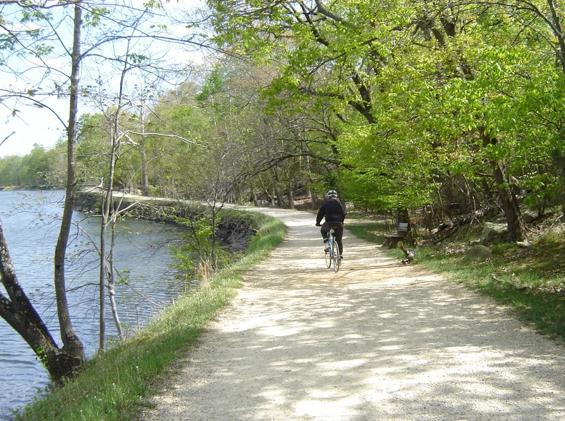
Rideable terrain here is noted as 160 miles, giving riders a clearer sense of scale before they ever unload. For equestrians, the park offers a rare opportunity to ride long distances on a relatively level trail. The historic towpath runs for more than 180 Miles beside the Potomac River, with approximately 160 Miles open to horseback riding. Riders follow the same packed-earth corridor once used by canal mules, passing through forests, farmland, and historic canal structures that remain largely unchanged since the 1800s.
Rideable terrain
160 miles
Trailer parking
Equestrian Trails C&O Canal Towpath Approx. 165 Miles of continuous rideable trail along the historic canal corridor. Horses are allowed on the towpath from Swains Lock (mile 16.6) to Offutt Street near Cumberland (mile 181.8). Riding is not allowed between Georgetown (mile 0) and Swains Lock, or on the final section from Offutt Street to the canal terminus. Trail characteristics Mostly flat towpath originally built for mule teams pulling canal boats. Surface is primarily dirt and gravel, with some crushed-stone sections. Scenic corridor follows the Potomac River through forests, cliffs, farmland, and historic canal structures. Special trail considerations Horses cannot go through Paw Paw Tunnel; riders must take the Tunnel Hill Trail over the ridge. Riders must dismount and lead horses across aqueducts. Narrow wooden footbridges are not designed for horses and cannot be crossed. Trailer Parking Because the park stretches 184 Miles across multiple states, there is no single equestrian staging area. Riders typically park at canal access lots located along the towpath and load horses from there. Common equestrian-friendly access areas include: Swains Lock (mile 16.6) One of the first legal horse access points. Gravel parking area with direct access to the towpath. Violettes Lock (mile 22) Canal access lot with parking, restrooms, and towpath entry. Point of Rocks / Brunswick area Several access lots with easier trailer maneuvering and immediate towpath access. Williamsport / Cushwa Basin (mile 99) Large access area with parking and amenities. Popular starting point for riding sections of the canal corridor. Because parking areas were originally designed for canal visitors rather than horse trailers, riders should expect gravel lots, limited turnaround space, and variable trailer suitability.
Horse regulations
Horseback riding is permitted along portions of Chesapeake & Ohio Canal National Historical Park, but it is restricted to specific sections of the historic canal towpath and must follow rules designed to protect park visitors, historic structures, and natural resources. Horses Are Allowed Only on Designated Sections of the Towpath Horses may only be ridden on the C&O Canal Towpath between Swains Lock (mile 16.6) and Offutt Street near Cumberland (mile 181.8). Riding is not permitted on the towpath between Georgetown (mile 0) and Swains Lock, where heavy pedestrian and bicycle traffic makes horseback riding unsafe. Horses must remain on the towpath or other areas specifically designated for stock use. Historic Structures and Restricted Crossings Because the park preserves historic canal infrastructure, horses must avoid certain structures: Riders must dismount and lead horses across aqueducts Horses cannot travel through the Paw Paw Tunnel and must use the Tunnel Hill Trail instead Horses are not permitted on narrow pedestrian bridges or footbridges that are not designed for livestock These restrictions help protect historic masonry structures and ensure visitor safety. Stay on the Towpath To protect park resources and the historic canal corridor: Cross-country riding is not allowed Riders may not create new trails or ride off the established towpath Horses must remain on the designated riding sections at all times Stock Control and Trail Courtesy The towpath is a heavily used multi-use trail shared with hikers and cyclists. Riders are expected to: Maintain control of horses at all times Ride single file where the trail narrows Yield appropriately to hikers and bicyclists Avoid damaging vegetation or historic structures Feed and Invasive Species Control To help prevent the spread of invasive plants: Riders should bring certified weed-free hay or feed Trailers, tack, and hooves should be cleaned before entering riding areas These measures help protect the park’s natural ecosystems. Camping With Horses Camping is allowed at designated hiker-biker campsites along the canal, but these areas were not specifically designed for horses. Riders staying overnight should: Follow Leave No Trace practices Manage manure responsibly Ensure horses do not damage vegetation or historic resources Some riders choose to stage overnight trips from private campgrounds or equestrian facilities outside the park that offer more suitable accommodations for horses.
Getting here
Use 142 W. Potomac St., Williamsport, Maryland as your primary planning reference before you haul in. Equestrian Trails C&O Canal Towpath Approx. 165 Miles of continuous rideable trail along the historic canal corridor. Horses are allowed on the towpath from Swains Lock (mile 16.6) to Offutt Street near Cumberland (mile 181.8). Riding is not allowed between Georgetown (mile 0) and Swains Lock, or on the final section from Offutt Street to the canal terminus. Trail characteristics Mostly flat towpath originally built for mule teams pulling canal boats. Surface is primarily dirt and gravel, with some crushed-stone sections. Scenic corridor follows the Potomac River through forests, cliffs, farmland, and historic canal structures. Special trail considerations Horses cannot go through Paw Paw Tunnel; riders must take the Tunnel Hill Trail over the ridge. Riders must dismount and lead horses across aqueducts. Narrow wooden footbridges are not designed for horses and cannot be crossed. Trailer Parking Because the park stretches 184 Miles across multiple states, there is no single equestrian staging area. Riders typically park at canal access lots located along the towpath and load horses from there. Common equestrian-friendly access areas include: Swains Lock (mile 16.6) One of the first legal horse access points. Gravel parking area with direct access to the towpath. Violettes Lock (mile 22) Canal access lot with parking, restrooms, and towpath entry. Point of Rocks / Brunswick area Several access lots with easier trailer maneuvering and immediate towpath access. Williamsport / Cushwa Basin (mile 99) Large access area with parking and amenities. Popular starting point for riding sections of the canal corridor. Because parking areas were originally designed for canal visitors rather than horse trailers, riders should expect gravel lots, limited turnaround space, and variable trailer suitability.
Planning your visit
One of the Longest Continuous Riding Corridors in the Eastern U.S. The C&O Canal Towpath offers roughly 165 Miles of rideable trail, making it one of the longest continuous horseback riding routes in the eastern United States. The trail follows the historic canal corridor along the Potomac River from Swains Lock near Washington, D.C., to Cumberland, Maryland. Flat, Historic Towpath Terrain The towpath was originally built for mule teams pulling canal boats, so it is mostly flat with gentle grades. The surface is typically dirt, crushed stone, and packed earth, making it suitable for long-distance riding. Multi-Use Trail with Heavy Traffic The towpath is shared with hikers, cyclists, and park visitors, especially near major access points. Riders should expect frequent encounters with other users and maintain careful horse control. Historic Structures Along the Route The park preserves historic canal infrastructure including locks, aqueducts, and tunnels. Riders must dismount and lead horses across aqueducts, and horses cannot pass through Paw Paw Tunnel, requiring riders to take the Tunnel Hill Trail over the ridge. Limited Trailer Facilities The park stretches nearly 184 Miles, and there is no single equestrian trailhead or horse facility. Riders typically stage from canal access parking areas along the route, which vary in size and maneuverability for trailers. Ideal for Long-Distance and Section Riding Many equestrians ride the canal in short sections, while some complete multi-day trips using the towpath’s long continuous corridor and nearby access points. Seasonal Trail Conditions Because the towpath runs beside the Potomac River, mud and flooding can occur after heavy rain, especially in low sections. Riders should check trail conditions before traveling. Historic and Scenic Riding Experience Unlike many national parks focused on rugged terrain, the C&O Canal provides a unique historic riding experience, traveling through forests, farmland, cliffs, and preserved canal towns along one of the most important transportation corridors of the 1800s
Where to stay
C & O Canal National Historical Park Headquarters is the main visitor-contact point tied to this destination, which is helpful when you want current conditions, maps, and stock-use updates before riding. This entry reads best as a bring-your-own-horse destination rather than a horse-rental stop, and amenities should be confirmed directly before travel. For a polished trip plan, pair the ride with lodging, fuel, and resupply planning in or near Williamsport before heading deeper into federal-land access points.
Entrance fees & passes
- $20.00
Entrance - Private Vehicle
Pass is for one private, non-commercial vehicle — passenger cars, pickup trucks, RVs and vans — and is valid at the Great Falls area of the Chesapeake and Ohio Canal National Historical Park on the Maryland side of the Potomac River and Great Falls Park on the Virginia side of the Potomac River.
- $15.00
Entrance - Motorcycle
Valid for 7 days. Admits up to 2 private, non-commercial motorcycles with up to 4 total passengers to the Great Falls area of the Chesapeake and Ohio Canal National Historical Park on the Maryland side of the Potomac River and at Great Falls Park on the Virginia side of the Potomac River.
- $10.00
Entrance - Per Person
Pass is for one person 16 years of age or older — entering on foot or by bicycle — and is valid at the Great Falls area of the Chesapeake and Ohio Canal National Historical Park on the Maryland side of the Potomac River and at Great Falls Park on the Virginia side of the Potomac River.
- $100.00
Entrance - Non-commercial Groups
Includes church groups, college/school groups, scouts, service organizations, military, etc... Vehicles with passenger capacity of fewer than 16 persons, $20 for the vehicle. Vehicles with a passenger capacity of 16 or more persons, $10 per person age 16 and over. Removal of seats from a vehicle does not then qualify for the lower rate. Age and pass exemptions apply. The total fee charged for an Organized Non-Commercial Group will not exceed the $100 fee per vehicle.
- $100.00
Commercial Entrance - Motor Coach
The commercial pass is valid for date of purchase plus six days at the Great Falls area of the Chesapeake and Ohio Canal National Historical Park on the Maryland side of the Potomac River. Please note that fees are based on vehicle capacity and not actual occupants.
- $40.00
Commercial Entrance - Van
The commercial pass is valid for date of purchase plus six days at the Great Falls area of the Chesapeake and Ohio Canal National Historical Park on the Maryland side of the Potomac River. Please note that fees are based on vehicle capacity and not actual occupants.
- $40.00
Commercial Entrance - Mini-bus
The commercial pass is valid for date of purchase plus six days at the Great Falls area of the Chesapeake and Ohio Canal National Historical Park on the Maryland side of the Potomac River. Please note that fees are based on vehicle capacity and not actual occupants.
- $25.00
Commercial Entrance - Sedan
The commercial pass is valid for date of purchase plus six days at the Great Falls area of the Chesapeake and Ohio Canal National Historical Park on the Maryland side of the Potomac River. Please note that fees are based on vehicle capacity and not actual occupants.
- $35.00
Annual Entrance - Park
Valid for one full year from the month of purchase. Permits access to the Great Falls area of the C&O Canal National Historical Park in Maryland and Great Falls Park in Virginia. The annual pass allows entrance for the pass holder and additional passengers in a single private non-commercial vehicle, or pass holder plus three adults when entering on foot or bicycle
Trails
No trails synced for this park yet.
Campgrounds
Antietam Creek Campground
20 sites
Mile 69.4 (Washington County, MD) - The campground has 20 single campsites each with a picnic table, fire ring and grill. Each campsite will accommodate up to eight campers. Pit toilets are located between campsite #6 and campsite #7 adjacent to the towpath. A second set of chemical toilets are available down the towpath. Potable water is along the towpath at pumps (available mid-April to mid-November). No vehicular traffic is allowed on the towpath and access to the campsites is by foot only.
Reserve a siteBald Eagle Island Hiker-Biker Campsite
1 sites · 1 horse-friendly
Mile 50.3 - Hiker-biker campgrounds are located along the towpath approximately every 5-7 miles. No fee or reservation required. Overnight stays are limited to one night. All sites include a chemical toilet, picnic table, grill, and water. Please Note: Water at hiker-biker campsites is non-potable. Water is not treated and not for drinking or cooking. If you use this water, you are advised to filter, chemically treat, or boil before use. Water is turned off from mid-November to mid-April each year.
Big Woods Hiker-Biker Campsite
1 sites · 1 horse-friendly
Mile 82.7 - Hiker-biker campgrounds are located along the towpath approximately every 5-7 miles. No fee or reservation required. Overnight stays are limited to one night. All sites include a chemical toilet, picnic table, grill, and water. Please Note: Water at hiker-biker campsites is non-potable. Water is not treated and not for drinking or cooking. If you use this water, you are advised to filter, chemically treat, or boil before use. Water is turned off from mid-November to mid-April each year.
Cacapon Junction Hiker-Biker Campsite
1 sites · 1 horse-friendly
Mile 133.6 - Hiker-biker campgrounds are located along the towpath approximately every 5-7 miles. No fee or reservation required. Overnight stays are limited to one night. All sites include a chemical toilet, picnic table, grill, and water. Please Note: Water at hiker-biker campsites is non-potable. Water is not treated and not for drinking or cooking. If you use this water, you are advised to filter, chemically treat, or boil before use. Water is turned off from mid-November to mid-April each year.
Calico Rocks Hiker-Biker Campsite
1 sites · 1 horse-friendly
Mile 47.6 - Hiker-biker campgrounds are located along the towpath approximately every 5-7 miles. No fee or reservation required. Overnight stays are limited to one night. All sites include a chemical toilet, picnic table, grill, and water. Please Note: Water at hiker-biker campsites is non-potable. Water is not treated and not for drinking or cooking. If you use this water, you are advised to filter, chemically treat, or boil before use. Water is turned off from mid-November to mid-April each year.
Chisel Branch Hiker-Biker Campsite
1 sites · 1 horse-friendly
Mile 30.5 - Hiker-biker campgrounds are located along the towpath approximately every 5-7 miles. No fee or reservation required. Overnight stays are limited to one night. All sites include a chemical toilet, picnic table, grill, and water. Please Note: Water at hiker-biker campsites is non-potable. Water is not treated and not for drinking or cooking. If you use this water, you are advised to filter, chemically treat, or boil before use. Water is turned off from mid-November to mid-April each year.
Cumberland Valley Hiker-Biker Campsite
1 sites · 1 horse-friendly
Mile 95.2 - Hiker-biker campgrounds are located along the towpath approximately every 5-7 miles. No fee or reservation required. Overnight stays are limited to one night. All sites include a chemical toilet, picnic table, grill, and water. Please Note: Water at hiker-biker campsites is non-potable. Water is not treated and not for drinking or cooking. If you use this water, you are advised to filter, chemically treat, or boil before use. Water is turned off from mid-November to mid-April each year.
Devils Alley Hiker-Biker Campsite
1 sites · 1 horse-friendly
Mile 144.5 - Hiker-biker campgrounds are located along the towpath approximately every 5-7 miles. No fee or reservation required. Overnight stays are limited to one night. All sites include a chemical toilet, picnic table, grill, and water. Please Note: Water at hiker-biker campsites is non-potable. Water is not treated and not for drinking or cooking. If you use this water, you are advised to filter, chemically treat, or boil before use. Water is turned off from mid-November to mid-April each year.
Evitts Creek Hiker-Biker Campsite
1 sites · 1 horse-friendly
Mile 180.1 - Hiker-biker campgrounds are located along the towpath approximately every 5-7 miles. No fee or reservation required. Overnight stays are limited to one night. All sites include a chemical toilet, picnic table, grill, and water. Please Note: Water at hiker-biker campsites is non-potable. Water is not treated and not for drinking or cooking. If you use this water, you are advised to filter, chemically treat, or boil before use. Water is turned off from mid-November to mid-April each year.
Fifteenmile Creek Campground
10 sites
Mile 140 (Allegany County, MD) - The campground has nine single drive-in campsites. There is one group site available that does not have direct vehicle access. The group site can accommodate 30 people. Each single will accommodate up to eight people. Single campsites have a picnic table, fire ring and grill. Pit toilets are located between campsite #3 and campsite #4 along the dead end circle. Potable water is available from mid-April to mid-November No motor vehicle traffic is allowed on the towpath.
Reserve a siteHorsepen Branch Hiker-Biker Campsite
1 sites · 1 horse-friendly
Mile 26.1 - Hiker-biker campgrounds are located along the towpath approximately every 5-7 miles. No fee or reservation required. Overnight stays are limited to one night. All sites include a chemical toilet, picnic table, grill, and water. Please Note: Water at hiker-biker campsites is non-potable. Water is not treated and not for drinking or cooking. If you use this water, you are advised to filter, chemically treat, or boil before use. Water is turned off from mid-November to mid-April each year.
Horseshoe Bend Hiker-Biker Campsite
1 sites · 1 horse-friendly
Mile 79.2 - Hiker-biker campgrounds are located along the towpath approximately every 5-7 miles. No fee or reservation required. Overnight stays are limited to one night. All sites include a chemical toilet, picnic table, grill, and water. Please Note: Water at hiker-biker campsites is non-potable. Water is not treated and not for drinking or cooking. If you use this water, you are advised to filter, chemically treat, or boil before use. Water is turned off from mid-November to mid-April each year.
Huckleberry Hill Hiker-Biker Campsite
0 sites
Mile 62.0 - Hiker-biker campgrounds are located along the towpath approximately every 5-7 miles. No fee or reservation required. Overnight stays are limited to one night. All sites include a chemical toilet, picnic table, grill, and water. Please Note: Water at hiker-biker campsites is non-potable. Water is not treated and not for drinking or cooking. If you use this water, you are advised to filter, chemically treat, or boil before use. Water is turned off from mid-November to mid-April each year.
Indian Flats Hiker-Biker Campsite
0 sites
Mile 42.5 - Hiker-biker campgrounds are located along the towpath approximately every 5-7 miles. No fee or reservation required. Overnight stays are limited to one night. All sites include a chemical toilet, picnic table, grill, and water. Please Note: Water at hiker-biker campsites is non-potable. Water is not treated and not for drinking or cooking. If you use this water, you are advised to filter, chemically treat, or boil before use. Water is turned off from mid-November to mid-April each year.
Indigo Neck Hiker-Biker Campsite
1 sites · 1 horse-friendly
Mile 139.2 - Hiker-biker campgrounds are located along the towpath approximately every 5-7 miles. No fee or reservation required. Overnight stays are limited to one night. All sites include a chemical toilet, picnic table, grill, and water. Please Note: Water at hiker-biker campsites is non-potable. Water is not treated and not for drinking or cooking. If you use this water, you are advised to filter, chemically treat, or boil before use. Water is turned off from mid-November to mid-April each year.
Irons Mountain Hiker-Biker Campsite
0 sites
Mile 175.3 - Hiker-biker campgrounds are located along the towpath approximately every 5-7 miles. No fee or reservation required. Overnight stays are limited to one night. All sites include a chemical toilet, picnic table, grill, and water. Please Note: Water at hiker-biker campsites is non-potable. Water is not treated and not for drinking or cooking. If you use this water, you are advised to filter, chemically treat, or boil before use. Water is turned off from mid-November to mid-April each year.
Jordan Junction Hiker-Biker Campsite
1 sites · 1 horse-friendly
Mile 101.2 - THiker-biker campgrounds are located along the towpath approximately every 5-7 miles. No fee or reservation required. Overnight stays are limited to one night. All sites include a chemical toilet, picnic table, grill, and water. Please Note: Water at hiker-biker campsites is non-potable. Water is not treated and not for drinking or cooking. If you use this water, you are advised to filter, chemically treat, or boil before use. Water is turned off from mid-November to mid-April each year.
Killiansburg Cave Hiker-Biker Campsite
1 sites · 1 horse-friendly
Mile 75.2 - Hiker-biker campgrounds are located along the towpath approximately every 5-7 miles. No fee or reservation required. Overnight stays are limited to one night. All sites include a chemical toilet, picnic table, grill, and water. Please Note: Water at hiker-biker campsites is non-potable. Water is not treated and not for drinking or cooking. If you use this water, you are advised to filter, chemically treat, or boil before use. Water is turned off from mid-November to mid-April each year.
Leopards Mill Hiker-Biker Campsite
1 sites · 1 horse-friendly
Mile 129.9 - Hiker-biker campgrounds are located along the towpath approximately every 5-7 miles. No fee or reservation required. Overnight stays are limited to one night. All sites include a chemical toilet, picnic table, grill, and water. Please Note: Water at hiker-biker campsites is non-potable. Water is not treated and not for drinking or cooking. If you use this water, you are advised to filter, chemically treat, or boil before use. Water is turned off from mid-November to mid-April each year.
Licking Creek Hiker-Biker Campsite
0 sites
Mile 116.0 - Hiker-biker campgrounds are located along the towpath approximately every 5-7 miles. No fee or reservation required. Overnight stays are limited to one night. All sites include a chemical toilet, picnic table, grill, and water. Please Note: Water at hiker-biker campsites is non-potable. Water is not treated and not for drinking or cooking. If you use this water, you are advised to filter, chemically treat, or boil before use. Water is turned off from mid-November to mid-April each year.
Little Pool Hiker-Biker Campsite
0 sites
Mile 120.4 - Hiker-biker campgrounds are located along the towpath approximately every 5-7 miles. No fee or reservation required. Overnight stays are limited to one night. All sites include a chemical toilet, picnic table, grill, and water. Please Note: Water at hiker-biker campsites is non-potable. Water is not treated and not for drinking or cooking. If you use this water, you are advised to filter, chemically treat, or boil before use. Water is turned off from mid-November to mid-April each year.
Marble Quarry Hiker-Biker Campsite
1 sites · 1 horse-friendly
Mile 38.2 - Hiker-biker campgrounds are located along the towpath approximately every 5-7 miles. No fee or reservation required. Overnight stays are limited to one night. All sites include a chemical toilet, picnic table, grill, and water. Please Note: Water at hiker-biker campsites is non-potable. Water is not treated and not for drinking or cooking. If you use this water, you are advised to filter, chemically treat, or boil before use. Water is turned off from mid-November to mid-April each year.
Marsden Tract Group Campground
6 sites
Mile 11.5 (Montgomery County, MD). The campground has six group campsites; sites accommodate up to 30 campers at each site. Each campsite has a picnic table and a fire ring. Potable water is located a short walk up the towpath and across the footbridge (water may not be available during cold winter months). Portable toilets are in the campground. No vehicle traffic is allowed on the towpath and access to the campsites is by foot only. Carderock Recreation Area or Anglers are the two closest parking areas.
Reserve a siteMccoys Ferry Campground
13 sites
Mile 110.4 (Washington County, MD) - The campground has 12 single drive-in campsites. Each single accommodates up to eight people. Single campsites have a picnic table, fire ring and grill. There is one group site available with space for two vehicles and a small trailer or support vehicle less than 20 ft. Group site can accommodate 30 people and has four picnic tables with grill and fire pit. Pit toilets and accessible portable toilets are available. Hand pump water is available April 15 - November 1.
Reserve a siteNorth Mountain Hiker-Biker Campsite
1 sites · 1 horse-friendly
Mile 110.0 - Hiker-biker campgrounds are located along the towpath approximately every 5-7 miles. No fee or reservation required. Overnight stays are limited to one night. All sites include a chemical toilet, picnic table, grill, and water. Please Note: Water at hiker-biker campsites is non-potable. Water is not treated and not for drinking or cooking. If you use this water, you are advised to filter, chemically treat, or boil before use. Water is turned off from mid-November to mid-April each year.
Opequon Junction Hiker-Biker Campsite
1 sites · 1 horse-friendly
Mile 90.9 - Hiker-biker campgrounds are located along the towpath approximately every 5-7 miles. No fee or reservation required. Overnight stays are limited to one night. All sites include a chemical toilet, picnic table, grill, and water. Please Note: Water at hiker-biker campsites is non-potable. Water is not treated and not for drinking or cooking. If you use this water, you are advised to filter, chemically treat, or boil before use. Water is turned off from mid-November to mid-April each year.
Paw Paw Tunnel Campground
10 sites
Mile 156 (Allegany County, MD) - There are 10 single campsites, each has a picnic table, fire ring and grill. Each site can accommodate eight people. If there is a larger group, reserve two sites next to each other. Portable toilets are available. Hamp pump water is available from April 15-November 1.
Reserve a sitePigmans Ferry Hiker-Biker Campsite
0 sites
Mile 169.1 - Hiker-biker campgrounds are located along the towpath approximately every 5-7 miles. No fee or reservation required. Overnight stays are limited to one night. All sites include a chemical toilet, picnic table, grill, and water. Please Note: Water at hiker-biker campsites is non-potable. Water is not treated and not for drinking or cooking. If you use this water, you are advised to filter, chemically treat, or boil before use. Water is turned off from mid-November to mid-April each year.
Potomac Forks Hiker-Biker Campsite
0 sites
Mile 164.8 - Hiker-biker campgrounds are located along the towpath approximately every 5-7 miles. No fee or reservation required. Overnight stays are limited to one night. All sites include a chemical toilet, picnic table, grill, and water. Please Note: Water at hiker-biker campsites is non-potable. Water is not treated and not for drinking or cooking. If you use this water, you are advised to filter, chemically treat, or boil before use. Water is turned off from mid-November to mid-April each year.
Purslane Run Hiker-Biker Campsite
1 sites · 1 horse-friendly
Mile 156.9 - Hiker-biker campgrounds are located along the towpath approximately every 5-7 miles. No fee or reservation required. Overnight stays are limited to one night. All sites include a chemical toilet, picnic table, grill, and water. Please Note: Water at hiker-biker campsites is non-potable. Water is not treated and not for drinking or cooking. If you use this water, you are advised to filter, chemically treat, or boil before use. Water is turned off from mid-November to mid-April each year.
Sorrel Ridge Hiker-Biker Campsite
1 sites · 1 horse-friendly
Mile 154.1 - Hiker-biker campgrounds are located along the towpath approximately every 5-7 miles. No fee or reservation required. Overnight stays are limited to one night. All sites include a chemical toilet, picnic table, grill, and water. Please Note: Water at hiker-biker campsites is non-potable. Water is not treated and not for drinking or cooking. If you use this water, you are advised to filter, chemically treat, or boil before use. Water is turned off from mid-November to mid-April each year.
Spring Gap Campground
14 sites
Mile 173.3 (Allegany County, MD) - Spring Gap Campground offers 12 single drive-in campsites and two drive-in group sites. Campsites 1, 2, 8, 11 and 13 can fit a single vehicle (i.e., car/pickup/van). Campsites 3-7, 12, 14 can fit a small 20 ft. or less RV/trailer/pop-up. Single sites can accommodate up to eight people. Each single has a picnic table, fire pit and grill. Campsites 9 and 10 are group sites capable of holding 30 people each. The group site has room for two vehicles.
Reserve a siteStickpile Hill Hiker-Biker Campsite
1 sites · 1 horse-friendly
Mile 149.4 - Hiker-biker campgrounds are located along the towpath approximately every 5-7 miles. No fee or reservation required. Overnight stays are limited to one night. All sites include a chemical toilet, picnic table, grill, and water. Please Note: Water at hiker-biker campsites is non-potable. Water is not treated and not for drinking or cooking. If you use this water, you are advised to filter, chemically treat, or boil before use. Water is turned off from mid-November to mid-April each year.
Swains Lock Hiker-Biker Campsite
5 sites
Mile 16.6 - Hiker-biker campgrounds are located along the towpath approximately every 5-7 miles. No fee or reservation required. Overnight stays are limited to one night. All sites include a chemical toilet, picnic table, grill, and water. Please Note: Water at hiker-biker campsites is non-potable. Water is not treated and not for drinking or cooking. If you use this water, you are advised to filter, chemically treat, or boil before use. Water is turned off from mid-November to mid-April each year.
Town Creek Hiker-Biker Campsite
1 sites
Mile 162.1 - Hiker-biker campgrounds are located along the towpath approximately every 5-7 miles. No fee or reservation required. Overnight stays are limited to one night. All sites include a chemical toilet, picnic table, grill, and water. Please Note: Water at hiker-biker campsites is non-potable. Water is not treated and not for drinking or cooking. If you use this water, you are advised to filter, chemically treat, or boil before use. Water is turned off from mid-November to mid-April each year.
Turtle Run Hiker-Biker Campsite
1 sites · 1 horse-friendly
Mile 34.4 - Hiker-biker campgrounds are located along the towpath approximately every 5-7 miles. No fee or reservation required. Overnight stays are limited to one night. All sites include a chemical toilet, picnic table, grill, and water. Please Note: Water at hiker-biker campsites is non-potable. Water is not treated and not for drinking or cooking. If you use this water, you are advised to filter, chemically treat, or boil before use. Water is turned off from mid-November to mid-April each year.
White Rock Hiker-Biker Campsite
1 sites · 1 horse-friendly
Mile 126.4 - Hiker-biker campgrounds are located along the towpath approximately every 5-7 miles. No fee or reservation required. Overnight stays are limited to one night. All sites include a chemical toilet, picnic table, grill, and water. Please Note: Water at hiker-biker campsites is non-potable. Water is not treated and not for drinking or cooking. If you use this water, you are advised to filter, chemically treat, or boil before use.
Points of interest
Abner Cloud House
POIAbner Cloud had this house built in the year 1801. If you look up, on the chimney, you can see the initials "A.C." and the date 1801. Abner Cloud lived here with his family until he died in 1812. His widow lived another 40 years.
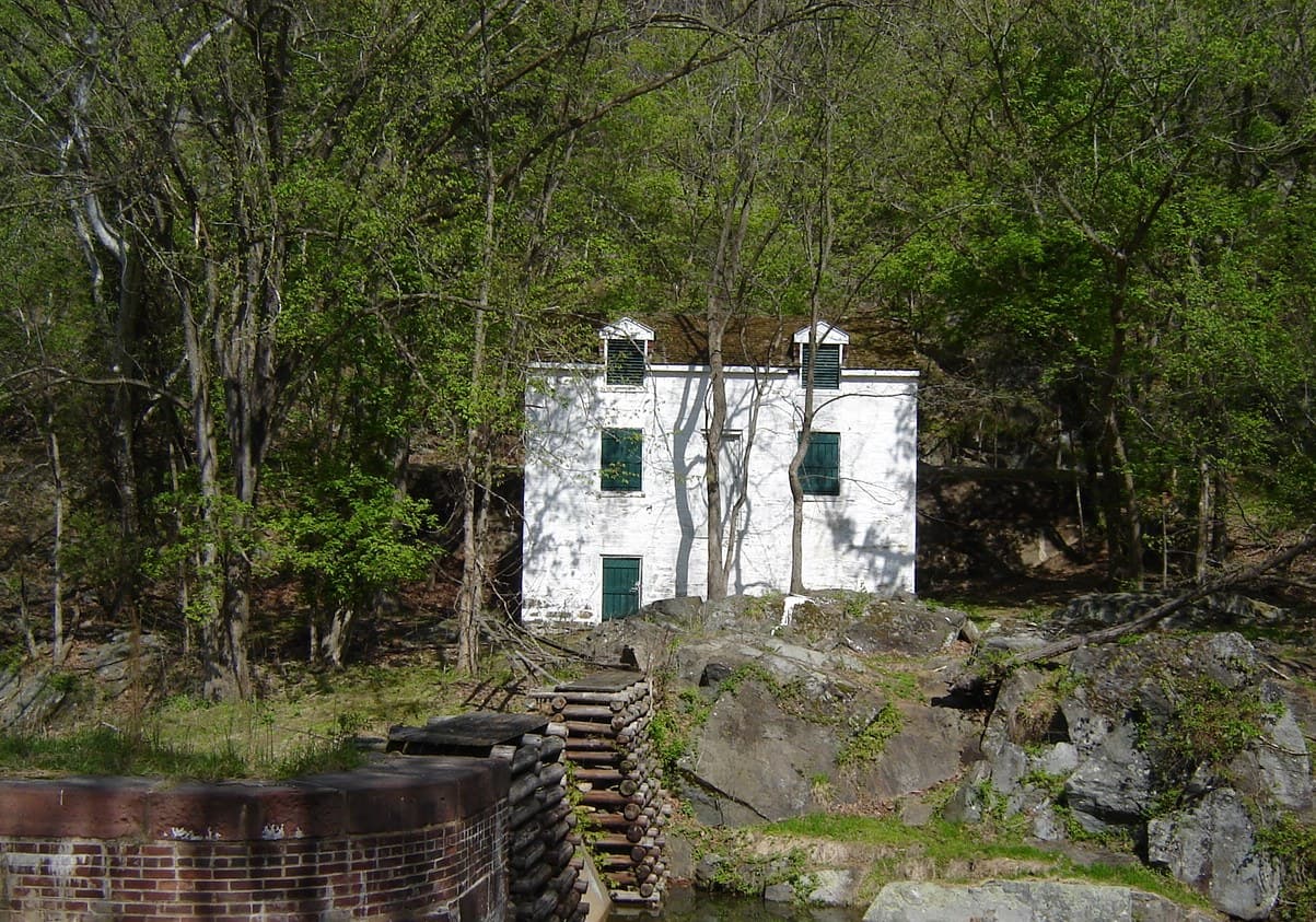
Abner Cloud Mill
POIAbner Cloud used the basement of his house to store grain and flour that came from his mill.
Antietam Aqueduct
POIAppalachian Forest National Heritage Area
POIThe Appalachian Forest National Heritage Area (AFNHA) works to conserve, enhance, interpret, and promote a regional network of forest heritage resources in the central Appalachian Highlands. Designated a National Heritage Area in 2019, AFNHA covers sixteen counties in West Virginia and two counties in western Maryland.
Big Slackwater Boat Ramp
POIBilly Goat Trail Section A Trailhead
POIBollman Bridge
POIBrunswick Boat Ramp
POICapital Crescent Trail terminus
POICatoctin Creek Aqueduct
POIC&O Canal Entrance Station
POIC&O Canal Ferry Hill
POILocated in Sharpsburg, Maryland, with a view toward Shepherdstown, West Virginia, Ferry Hill has stood for two centuries above the Potomac River and the Chesapeake & Ohio Canal, participating in and watching history pass by. Ferry Hill is best known as the home of Henry Kyd Douglas, Confederate Officer and author of his Civil War personal account, "I Rode With Stonewall."
C&O Canal Incline Plane
POITo alleviate traffic congestion on the C&O Canal, the Incline Plane allowed coal boats to be transported down to the Potomac River by means of a system of caissons, pulleys, steel cables and counterweights. After an accident in 1877 in which three men were killed, the caissons were drained of water before the boats descended. In 1878, 1,918 trips were recorded on the Incline Plane. Also in that year, a model of the Incline Plane was exhibited at the World's Fair in Paris. Aft
C&O Canal Inlet lock
POIInlet lock 1 is where water is diverted from the Potomac River into the five miles of the Georgetown section of the C&O Canal. Eight dams at various points along the canal allowed water to flow into the eight sections. If one of the eight sections were damaged, the canal company could close just one section to affect repairs - they did not have to shut down the whole canal!
C&O Canal Intake
POIThis is one of series of intakes that provided water to help power the mills in this area including a flour and a paper mill. Providing water to the mills was another form of income for the canal company. At least one intake was in used until the 1960's.
C&O Canal Intakes
POIThis is one of series of intakes that provided water to help power the mills in this area including a flour and a paper mill. <br /><br />Thees are ruins of two dual intakes for the Wilkins Rogers Milling Company water intake ruins are located on river (Fishmarket Square) side of the canal. When operational, each intake consisted of two intake openings stacked directly on top of each other. They supplied the former mill to the south with surplus canal water from 1839 to 1960. <br />
C&O Canal Lock 1
POIThe very first lock on the C&O Canal. Locks are like elevators and allow boats to move up in elevation. By closing and opening the lock gates in the right order, one can fill or empty the lock chamber. This will raise or lower the boat.Seventy-three more locks over the next 183 miles lead into Cumberland, Maryland in the Allegheny Mountains. Today, visitors can still travel the towpath, tracing the same route as mules and canal boats more than 100 years ago.From the shore of
C&O Canal Lock 10 (Seven Locks)
POIC&O Canal Lock 11
POIC&O Canal Lock 12
POIC&O Canal Lock 13
POIC&O Canal Lock 14
POIC&O Canal Lock 15
POIC&O Canal Lock 16
POIC&O Canal Lock 17
POIC&O Canal Lock 18
POIC&O Canal Lock 19
POIC&O Canal Lock 2
POICan you find the words "TE AMO" ("I love you" in Latin and Spanish) on the capstones of Lock 2? They were chiseled by an unknown mason for an unknown reason. Chances are, he was unable to finish the inscription - witness the letters PA in the lower left hand corner. What was the rest of that word to be? The rest of the inscription? Do you wonder what he intended to say?If you look down into the lock chamber, you can still see the original timber foundation from construction
C&O Canal Lock 20
POIC&O Canal Lock 21 (Swains Lock)
POIC&O Canal Lock 22 (Pennyfield Lock)
POIC&O Canal Lock 23 (Violettes Lock)
POIC&O Canal Lock 24 (Rileys Lock)
POIC&O Canal Lock 25
POIC&O Canal Lock 26
POIC&O Canal Lock 27
POIC&O Canal Lock 28
POIC&O Canal Lock 29 (Lander)
POIC&O Canal Lock 3
POILike all the lift locks on the canal, canal boats could be raised for an upstream journey or lowered for a downstream journey by opening and closing the lock doors in the correct sequence. Lift Lock 3 was restored in 2016-2019. The lock was fully disassembled, the original wood foundation removed and replaced with a re-enforced concrete foundation, and the lock rebuilt using as much of the original stone as possible.
C&O Canal Lock 30
POIC&O Canal Lock 31
POIC&O Canal Lock 32
POIC&O Canal Lock 34
POIC&O Canal Lock 35
POIC&O Canal Lock 36
POIC&O Canal Lock 37
POIC&O Canal Lock 38 (Shepherdstown)
POIC&O Canal Lock 39
POIC&O Canal Lock 4
POIAlong the 184.5 miles of the canal are 74 lift locks. These locks were put into place to help boats overcome the 605-foot elevation change between Georgetown and Cumberland. The C&O Canal is like a staircase, canal boats traveled along the flat sections and used the locks to take a “step up or down” about eight feet. The locks typically had hand-operated miter gates that were simple and followed Leonardo da Vinci’s original 1485 design.
C&O Canal Lock 40
POIC&O Canal Lock 41
POIC&O Canal Lock 42
POIC&O Canal Lock 43
POIC&O Canal Lock 44 (Williamsport)
POIC&O Canal Lock 45
POIC&O Canal Lock 46
POIC&O Canal Lock 47
POIC&O Canal Lock 48
POIC&O Canal Lock 49
POIC&O Canal Lock 5
POIIn 1829, President John Quincy Adams laid the cornerstone of Lock #5. Floods damaged the lock in the 19th century, and the upper red sandstone stones were added, probably to avert even more flood damage. The lower, grey-colored stone is original and came from Aquia creek and from a quarry less than 1 mile form this site. Level 4, between Lift Lock 5 and Lift Lock 4 (between Thomas Jefferson St and 31st Street in Georgetown, Washington DC) is four miles long.
C&O Canal Lock 50
POIC&O Canal Lock 51
POIC&O Canal Lock 52
POIC&O Canal Lock 53
POIC&O Canal Lock 54
POIC&O Canal Lock 55
POIC&O Canal Lock 56
POIC&O Canal Lock 57
POIC&O Canal Lock 58
POIC&O Canal Lock 59
POIC&O Canal Lock 6
POIC&O Canal Lock 60
POIC&O Canal Lock 61
POIC&O Canal Lock 62
POIC&O Canal Lock 63
POIC&O Canal Lock 64
POIC&O Canal Lock 66
POIC&O Canal Lock 67
POIC&O Canal Lock 68
POIC&O Canal Lock 69
POIC&O Canal Lock 70
POIC&O Canal Lock 71
POIC&O Canal Lock 72
POIC&O Canal Lock 73
POIC&O Canal Lock 74
POIC&O Canal Lock 75
POIC&O Canal Lock 7 (Glen Echo)
POIC&O Canal Lock 8 (Seven Locks)
POIC&O Canal Lock 9
POIC&O Canal Lockhouse 10 Canal Quarters
POIC&O Canal Lockhouse 21 Canal Quarters
POIC&O Canal Lockhouse 22 Canal Quarters
POIC&O Canal Lockhouse 25 Canal Quarters
POIC&O Canal Lockhouse 28 Canal Quarters
POIC&O Canal Lockhouse 29 (Lander)
POIC&O Canal Lockhouse 44
POIC&O Canal Lockhouse 49 Canal Quarters
POIC&O Canal Lockhouse 6 Canal Quarters
POIC&O Canal Mile 0
POIFrom this point, hikers and bikers can state unequivocally that they have ended - or are just starting- their full trip on the C&O Canal towpath. The towpath follows along the canal for 184.5 miles to the Cumberland, MD terminus. Many bikers begin in Pittsburgh and travel the Great Allegheny Passage (GAP) trail to Cumberland and then follow the towpath to here for a total trip of 333 miles.If you are a through biker or hiker reaching the end of your journey, Congratulations!!
C&O Canal Mile 4
POIThis is the fourth mile marker on the C&O Canal - only 178.5 miles to go until Cumberland!
C&O Canal Mule Drink and Overflow
POIManaging water levels both during normal canal operations and during floods was and still is a key task. Water for the canal comes in at series of inlet locks. Inlet Lock 1, which is at Lift Lock 5 over the Washington, DC boundary in Maryland, feeds the Georgetown section. Waste Weirs (a gate in the side of the canal) and the lift lock gates can be used used to adjust levels. There are also spillways along the canal, which are also referred to as "mule drinks" that operate l
C&O Canal Outtake
POIGeorgetown was once an industrial area. The building across the canal is the former Capital Traction Powerhouse, which provided power for the streetcars in Georgetown. There were outtake pipes that were used to blow off steam from the boilers. Early on the morning of September 11, 2016, the Spong family was moored to the concrete wall theat ran beneath the powerhouse, right at a steam pipe. At usual time, 6 am, the powerhouse blew out the boilers and the steam burst and forc
C&O Canal Park Headquarters
POIC&O Canal Spillway
POIThe spill way is used to let high water in the canal flow back into the Potomac River. The spillway is also known as a "mule drink" as it is a low and convenient place for the canal mules to have a drink of water.
C&O Canal Tidelock
POICoal boats navigating the C&O Canal could use the tidelock to lock through between the Potomac River and Rock Creek, The used the last 1/4 of mile of the creek. Canal boats could then be taken nearby wharf or down river to unload at a power plant or warehouse along the Potomac. A dam with a waste gate went across the mouth of Rock Creek and was used to maintain a steady water level in Rock Creek for canal operations instead of having the creek get lower with a low tide. Ther
C&O Canal Waste Weir
POIIf the water level in the canal rose too high, paddles at the bottom of the gate could be opened to allow excess water to flow back into the Potomac.
Conococheague Aqueduct
POIDam 3
POIDam 4
POIDargan Bend Boat Ramp
POIEdwards Ferry Boat Ramp
POIEvitts Creek Aqueduct
POIFifteenmile Creek Aqueduct
POIFishmarket Square
POIWhere's the market? While the current brick plaza was constructed in the 1980s, the history goes back to the 1790s. Before the canal was built, this plaza and the space on the other side of the canal was market and jail. Across the canal is the 1865 Market building, built to replace the 1795 market. After the canal cut the market in two, this portion became a fish market.
Fletchers Cove
POIHere at Fletchers Cove, you can picnic, fish, boat, and ride your bike. You can also visit the Fletcher's Boathouse concession stand or just sit and enjoy the scenery. You can also purchase your DC fishing license. This is a popular stop for hikers and bikers on the C&O Canal, or on the Capital Crescent Trail.
Four Locks Boat Ramp
POIFoxhall-Columbia Foundry Complex Ruins
POIThese ruins are the remnants of a once bustling foundry. Nothing remains of foundry building itself, however these walls ruins of outbuildings. The Foxhall-Columbia Foundry was active from 1800-1854. It supplied cannon to the US Army and from 1800-1809 was the exclusive supplier of cannon. In the early years, the foundry was very productive and successful, however by the 1840's it had fallen in prominence.This the namesake of Foundry Branch, a creek which is just upstream of
Francis Scott Key Bridge
POIThe Francis Scott Key bridge crosses the Potomac River and connect Georgetown on the Washington, DC to Rossyln on the Virginia side. The bridge was completed in 1924. It replaced Aqueduct Bridge as the new Georgetown river crossing. The Aqueduct bridge was final transportation role of the Potomac Aqueduct that connect the C&O Canal and the Alexandria Canal. You can see one of the aqueduct abutments along the towpath just upstream from here.
Information Panel: Georgetown Visitor Center (Closed)
POIThis building located at 1057 Thomas Jefferson St.
Information Panel: Lock 5
POIWaysides provide safety information and orientation.
Information Panel: River Warnings!
POIWaysides provide safety information and orientation.
Key Bridge Boathouse
POIKey Bridge Boathouse is managed by Boating in DC and provides visitors the opportunity to rent kayaks, canoes, and stand-up paddleboards.
Lander Boat Ramp
POILicking Creek Aqueduct
POILittle Falls Branch
POILittle Falls Branch drains from Maryland and Washington DC and flows under C&O Canal into the Potomac River at Little Falls rapids. The rapids mark the upstream end of the tidal Potomac. In the 1800's, a dam diverted water from the stream into the reservoirs that supplied the District Of Columbia with water. When the Washington Aqueduct was built, the dams were removed. Streams like the Little Falls Branch, flow under the canal through culverts. There are approximately 180 cu
Little Tonoloway Boat Ramp
POILow water intake
POIMaryland Heights
POIThe majority of hikers ascend Maryland Heights in search of a good view or a healthy workout. This mountain offers both hikes and scenic overlooks which will not disappoint. If history is your thing, Maryland Heights has remnants of extensive Civil War campsites and fortifications and its elevation made it hugely important during the war. To access this area, walk from Lower Town across the footbridge over the Potomac River to the C&O Canal towpath then take a left and walk a
McCoys Ferry Boat Ramp
POIMonocacy Aqueduct
POIThe glistening white and pink quartz sandstone structure is the longest aqueduct along the C&O Canal measuring 516 feet.
Monocacy Aqueduct Boat Ramp
POINolands Ferry Boat Ramp
POIOlmsted Island and Overlook Trail
POIPaw Paw Tunnel
POIPoint of Rocks Boat Ramp
POIPotomac Aqueduct
POIFrom 1843 to 1886, coal boats navigated across the Potomac Aqueduct - actually over the Potomac - on their way via the Alexandria Canal to the wharves of Alexandria, about 7 miles south of here. Later, the aqueduct became part of a trolley line from Rosslyn to Georgetown. If you look across the river, you can still see the only remaining pier.
Potomac River Bridge Ruins
POIRailroad Lift Bridge
POISeneca Aqueduct
POISideling Hill Creek Aqueduct
POISnyders Landing Boat Ramp
POITaylors Landing Boat Ramp
POIThe Cumberland (replica boat)
POIThompson Boat Center
POIBoat rentals and lessons on the Potomac River
Tonoloway Aqueduct
POITown Creek Aqueduct
POIWashington Aqueduct
POIThe construction and successful operation of the Washington Aqueduct epitomizes the Army Corps of Engineers entry into the field of public works and reflects the military influence on civil life in antebellum America. The Washington Aqueduct, constructed over 150 years ago, still supplies the nation's capital with public water today.
Wisconsin Avenue bridge
POIThis is the oldest masonry bridge in Washington, DC. It predates the incorporation of Georgetown into Washington, DC. Note the name on the eastside keystone - O(rville). B. Dibble - the engineer of the Wisconsin Ave. Bridge. Note also the name of Andrew Jackson - engraved on a stone plaque - who dedicated this bridge upon its completion in 1828. The bridge allowed traffic to cross the canal.
Things to do
Bicycle from Williamsport to Harpers Ferry
Want to explore history and enjoy a day bicycling? This is the route for you. Enjoy a leisurely 40-mile bike ride, or choose to hike and or paddle the length instead, spending the night camping or staying in paid accommodations. Historic treasures await you in Williamsport, Shepherdstown, and Harpers Ferry along the way.
Duration: 1-3 Days
Bike the C&O Canal Towpath
By bicycle or on foot, try a short day trip or travel the entire 184.5-mile length of the Chesapeake and Ohio Canal Towpath.
Duration: 3-5 Days
Explore the C&O Canal Williamsport Visitors Center
Visit the Williamsport Visitor Center at Cushwa Basin for information about the Canal and the surrounding area, sites including an aqueduct, rail lift-bridge, lockhouse, and operable locks.
Duration: 20-60 Minutes
Explore the Georgetown Waterfront
Explore the Georgetown Waterfront and imagine the changes the space has gone through.
Duration: 60-160 Minutes
Explore the Trolley Barn at Cushwa Basin
The trolley barn is located across the parking lot from the Cushwa Building. In 1896, the first trolley line in Washington County, Maryland was built running from Williamsport to Hagerstown. The water supply from the Conococheague Creek made this location ideal for a steam-powered generating station. Today, the trolley barn contains historic photos, historic toys, children's costumes, a scale model of a canal boat’s mule stable, and dioramas.
Duration: 15-60 Minutes
Hike Along the Towpath Through the Paw Paw Tunnel
Walk through the 3,118-foot Paw Paw Tunnel, a significant engineering feature along Mile 155 of the C&O Canal towpath.
Duration: 1-2 Minutes
Paddle the Middle Potomac
Paddle from Potoma (sic) Wayside, at the confluence of the Shenandoah and Potomac rivers, or another launch site and take out at Algonkian Regional Park or Riverbend Park (both Virginia side). Camp at sites along the C & O Canal Towpath, reserve a night in a historic lockhouse (river left upstream of Point of Rocks), reserve a cabin at Algonkian Regional Park (two-night minimum) or find a B & B or hotel. This trip can be combined with hiking and bicycling.
Duration: 2-4 Days
Skiing and Snowshoeing the C&O Canal Towpath
During the winter months, the C&O Canal may accumulate enough snow for winter activities like skiing and snowshoeing. Visitors can step out onto the towpath and enjoy a short or multi-mile journey along the historic canal
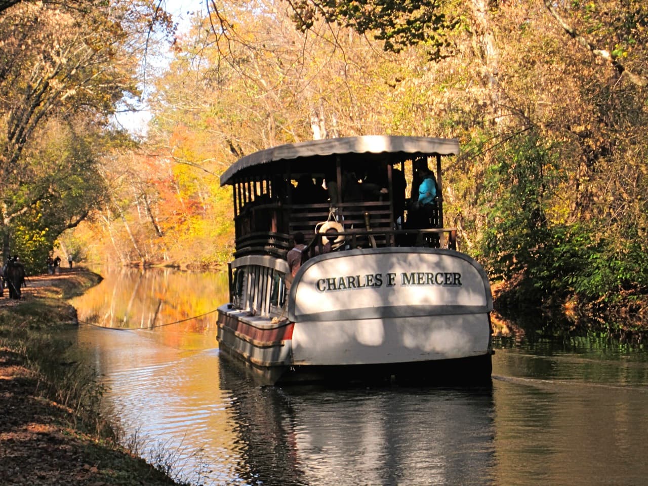
Take a Boat Ride on the Canal
Today, visitors can enjoy life on the canal during a free replica canal launch boat program at Williamsport. During the late 19th and early 20th century, 30-foot battery and steam powered launch boats traveled the canal for leisure and business.
Duration: 1-1 Hours
Wildlife Watching - Oldtown C&O Canal
Head down the C&O Canal NHP towpath in Oldtown, Maryland into a rare ecosystem mirroring that of the West. Spot a variety of wildlife and dragonfly species in this secluded hotspot.
Duration: 2-4 Hours
Visitor centers
Brunswick Visitor Center
The Brunswick Visitor Center is located just off the C&O Canal towpath at mile 55 in Frederick County, MD. The visitor center shares a building with the Brunswick Heritage Museum. For over a century Brunswick has been a railroad town. This once bustling company town is now a quiet place since the decline of the railroads. The remains of the rail yard are still visible from the canal towpath.
Get directionsCumberland Visitor Center
The Cumberland Terminus Visitor Center is located at mile 184.5 along the C&O Canal towpath in Allegany County, MD. Located in the Western Maryland Railway station, the visitor center features a spacious exhibit area full of interactive displays about the history of the C&O Canal and Cumberland. Pass through a model of the Paw Paw Tunnel and step back into the hey day of the canal. Awaiting you is a life size section of a canal boat. View exhibits on the canal's construction, cargo, mules, locks, and crew.
Get directionsGeorgetown Visitor Center
The Georgetown Visitor Center is located at mile 0.4 along the C&O Canal towpath in Washington, DC. Information about the National Park Service in Georgetown can be found at the Old Stone House (Rock Creek Park), located at 3051 M Street NW, Washington, DC 20007.
Get directionsGreat Falls Tavern Visitor Center
The Great Falls Tavern Visitor Center is located at mile 14.3 (Lock 20) along the C&O Canal towpath in Potomac, MD.
Get directionsWilliamsport Visitor Center
The Cushwa Basin Visitor Center in Williamsport is located at mile 99.8 along the C&O Canal towpath in Washington County, MD. Situated at the confluence of the Conococheague Creek and the Potomac River, Williamsport was first settled in 1740. A half-mile rewatered section of canal leads through the turning basin, under the only railroad lift bridge on the canal, and continues to Lockhouse 44 and the adjacent lock. The Conocheague Aqueduct is located across from the turning basin.
Get directions
Hours of operation
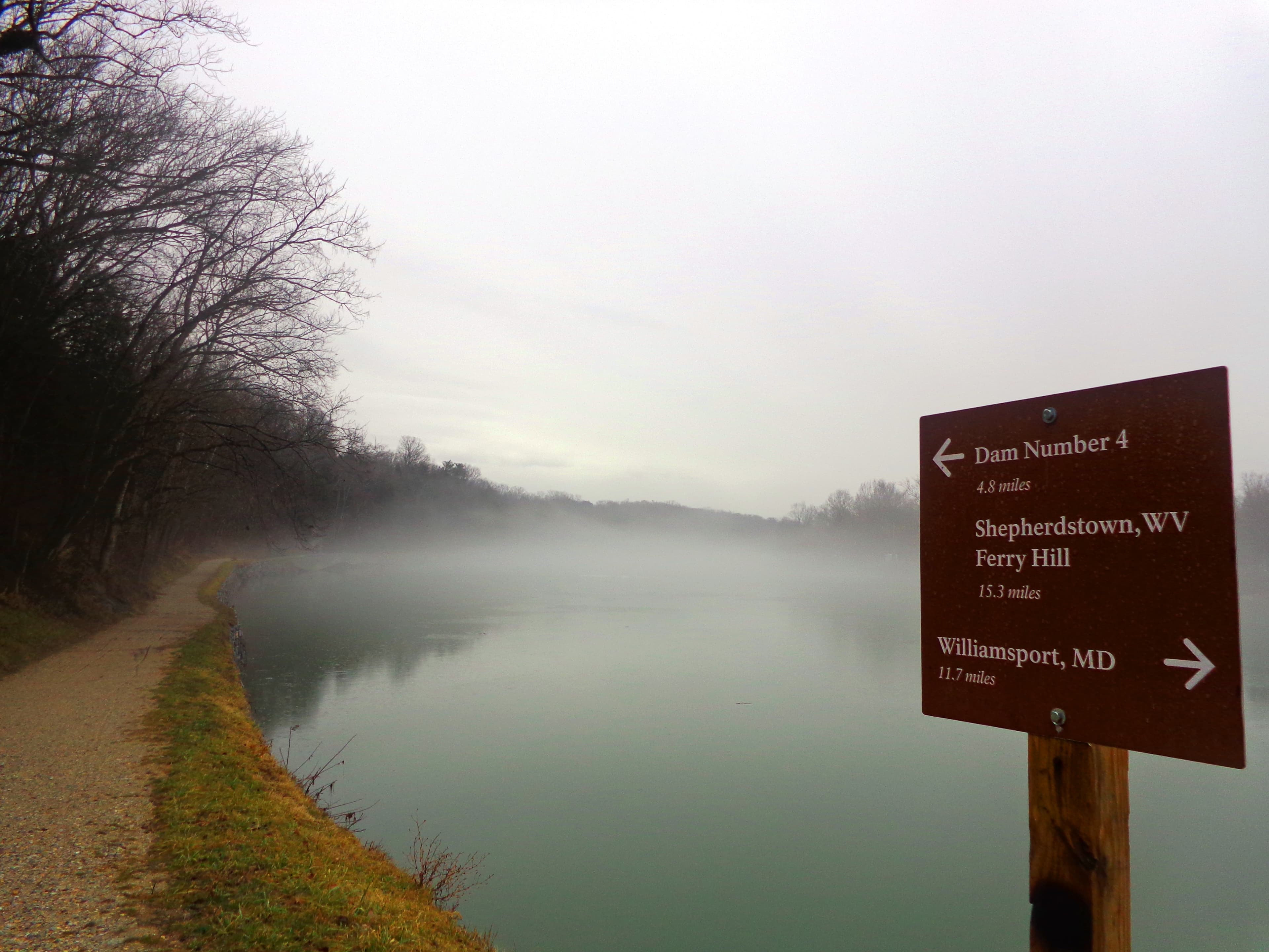
C&O Canal Towpath
The towpath is open 365 days a year.
Mon
Sunrise to Sunset
Tue
Sunrise to Sunset
Wed
Sunrise to Sunset
Thu
Sunrise to Sunset
Fri
Sunrise to Sunset
Sat
Sunrise to Sunset
Sun
Sunrise to Sunset
Activities
Weather
The Washington, DC, area has a four-season Mid-Atlantic climate. Summertime is warm and humid, while winter can be cold and snowy. Precipitation averages 2-4” monthly, year-round. The climate gradually gets cooler and wetter further west along the canal where the elevation is higher.
Contact
Photos
Stay near this park
No horse-friendly stays listed near Chesapeake & Ohio Canal National Historical Park yet. Know a great barn or property? Help fellow riders by listing it.
List your propertyDirections
The park has numerous access points. There is no main entrance. In Washington, DC, the C&O Canal begins at mile 0 in Georgetown near 29th St NW, south of M St, and runs alongside Canal Rd to the west. The entrance to Great Falls Tavern area is at MacArthur Blvd and Falls Rd in Potomac, MD. Park Headquarters and the Cushwa Basin Visitor Center are in Williamsport, MD off I-81 at exit 2. The Cumberland Terminus Visitor Center and mile 184.5 are off I-68 at exit 43C. See the maps page for more.
Source: nps.gov