
Information
Current East Rim Trail Status: Open
As of Tuesday, June 16, 2026, the East Rim Trail System remains open. For more information, visit the website linked below. In good conditions the mountain bike trails are open 6 am-11 pm for bikers and as posted for other trail users. In wet or hazardous conditions, the trail will close to all users to prevent damage. Be flexible; conditions may change throughout the day.
More infoInformation
Expect Crowding
Parking lots and popular destinations are crowded especially on weekends and days with warm weather between 10 am and 3 pm.
Caution
Vehicle Break-in and Theft Warning
Car break-ins in Cuyahoga Valley have tripled since 2022, resulting in theft of personal items like credit cards. Do not leave valuables in your car. As a last resort, lock items in your trunk before arriving. Thieves target parking lots regularly.
Cuyahoga Valley National Park
OH · Peninsula,
Though a short distance from the urban areas of Cleveland and Akron, Cuyahoga Valley National Park seems worlds away. The park is a refuge for native plants and wildlife, and provides routes of discovery for visitors. The winding Cuyahoga River gives way to deep forests, rolling hills, and open farmlands. Walk or ride the Towpath Trail to follow the historic route of the Ohio & Erie Canal.
Riding guide
Highlights
Cuyahoga Valley National Park in northeastern Ohio preserves a lush river valley where forests, rolling hills, wetlands, and…
Riding
Rideable terrain here is noted as 20 miles, giving riders a clearer sense of scale before they ever unload. For equestrians, the park offers a network of designated bridle trails that wind through wooded hillsides and creek valleys primarily on the eastern side of the river. These trails pass through mature forests and gentle terrain, providing a shaded riding experience with occasional views of historic farm fields and the surrounding valley landscape. The footing is generally moderate and well suited for relaxed trail riding rather than technical riding.
Rideable terrain
20 miles
Trailer parking
Valley Bridle Trailhead (Riverview Road / Boston Mill Area) Primary staging area for riders accessing the main bridle trail network in Cuyahoga Valley National Park. This gravel trailhead sits along Riverview Road near the Boston Mill area and provides direct entry to several of the park’s core horse trails, including Wetmore, Butler, and Tabletop trails. Why riders use it Direct access to multiple bridle trail loops Gravel surface suitable for horse trailers Central location within the park’s equestrian trail system Stanford House / Wetmore Trailhead This trailhead near the historic Stanford House provides convenient access to the Wetmore Trail and surrounding bridle trail connections. Riders often stage here to access wooded trail sections along the eastern side of the Cuyahoga Valley. Why riders use it Access to the Wetmore Trail and connecting bridle routes Parking area suitable for staging horses Scenic wooded trails nearby Pine Lane Trailhead (East Side Bridle Access) Pine Lane provides a quieter access point to the park’s bridle trail system and connects riders to several interior horse trail loops through forests and rolling terrain. Why riders use it Quieter access point away from busier park areas Direct entry to interior bridle trails Good option when other trailheads are busy
Horse regulations
Horseback riding at Cuyahoga Valley National Park is permitted on designated bridle trails and is managed to protect the park’s forests, wetlands, and historic landscapes. Equestrian use is concentrated on a network of horse trails primarily located on the eastern side of the Cuyahoga River. Riders should review park guidelines before visiting and plan accordingly, as horse access is limited to specific trails. However, several core regulations and best practices apply for riders in the park. Riding Is Only Allowed on Designated Trails Horses and other pack animals are permitted only on the park’s designated bridle trails, including routes such as Wetmore Trail, Butler Trail, Tabletop Trail, Riding Run Trail, and Perkins Trail. Riding on hiking-only trails, the Ohio & Erie Canal Towpath Trail, or off established routes is prohibited. Trail Access and Conditions Equestrian trails in the park travel through forested hills, ravines, and rolling terrain. Trails may become muddy after rain and riders should avoid riding during wet conditions to prevent trail damage. Feed and Invasive Species Control To help protect native ecosystems, riders must bring: Certified weed-free hay or feed Clean trailers, tack, and hooves before entering riding areas These measures help prevent the spread of invasive plant species. Stock Control and Trail Courtesy Riders are expected to: Maintain control of horses at all times Ride single file where trails are narrow Yield appropriately to hikers and other trail users Avoid damaging vegetation or creating new trails Sensitive Areas and Wildlife Horses should remain on designated bridle trails and avoid wetlands, creek banks, and sensitive natural areas unless the trail specifically crosses these features. Camping With Horses Horse camping facilities are not provided within Cuyahoga Valley National Park. Riders planning overnight trips with horses should arrange accommodations outside the park and return for day rides on the designated bridle trail system.
Getting here
Use 6947 Riverview Road, Peninsula,, Ohio as your primary planning reference before you haul in. Valley Bridle Trailhead (Riverview Road / Boston Mill Area) Primary staging area for riders accessing the main bridle trail network in Cuyahoga Valley National Park. This gravel trailhead sits along Riverview Road near the Boston Mill area and provides direct entry to several of the park’s core horse trails, including Wetmore, Butler, and Tabletop trails. Why riders use it Direct access to multiple bridle trail loops Gravel surface suitable for horse trailers Central location within the park’s equestrian trail system Stanford House / Wetmore Trailhead This trailhead near the historic Stanford House provides convenient access to the Wetmore Trail and surrounding bridle trail connections. Riders often stage here to access wooded trail sections along the eastern side of the Cuyahoga Valley. Why riders use it Access to the Wetmore Trail and connecting bridle routes Parking area suitable for staging horses Scenic wooded trails nearby Pine Lane Trailhead (East Side Bridle Access) Pine Lane provides a quieter access point to the park’s bridle trail system and connects riders to several interior horse trail loops through forests and rolling terrain. Why riders use it Quieter access point away from busier park areas Direct entry to interior bridle trails Good option when other trailheads are busy
Planning your visit
Riding within Cuyahoga Valley National Park is limited to designated bridle trails located primarily on the east side of the Cuyahoga River. Horses are not allowed on hiking-only trails or on the Ohio & Erie Canal Towpath Trail. Riders must remain on marked bridle routes at all times. The park’s horse trails travel through wooded hills, ravines, and rolling valley terrain. Trails can become muddy after rain, and riders should avoid riding in wet conditions to help protect the trail surface. Horse trailer staging is commonly done at equestrian trailheads such as the Valley Bridle Trailhead along Riverview Road and other designated bridle trail access points. Parking space may be limited for large rigs during busy periods. Horse facilities within the park are minimal. Riders should plan to be self-sufficient and bring water, feed, and all necessary supplies for both horses and riders. Use certified weed-free hay or feed to help prevent the spread of invasive plant species. Cleaning trailers, hooves, and tack before entering riding areas is recommended to help protect the park’s ecosystems. Keep horses on designated bridle trails and away from wetlands, creek banks, and other sensitive natural areas unless the trail specifically crosses these features. Horse camping is not available within Cuyahoga Valley National Park. Riders planning overnight trips should arrange accommodations outside the park and return for day rides on the designated bridle trail system.
Where to stay
Boston Mill Visitor Center is the main visitor-contact point tied to this destination, which is helpful when you want current conditions, maps, and stock-use updates before riding. This entry reads best as a bring-your-own-horse destination rather than a horse-rental stop, and amenities should be confirmed directly before travel. For a polished trip plan, pair the ride with lodging, fuel, and resupply planning in or near Peninsula, before heading deeper into federal-land access points.
Trails
No trails synced for this park yet.
Campgrounds
No campgrounds listed for this park.
Points of interest
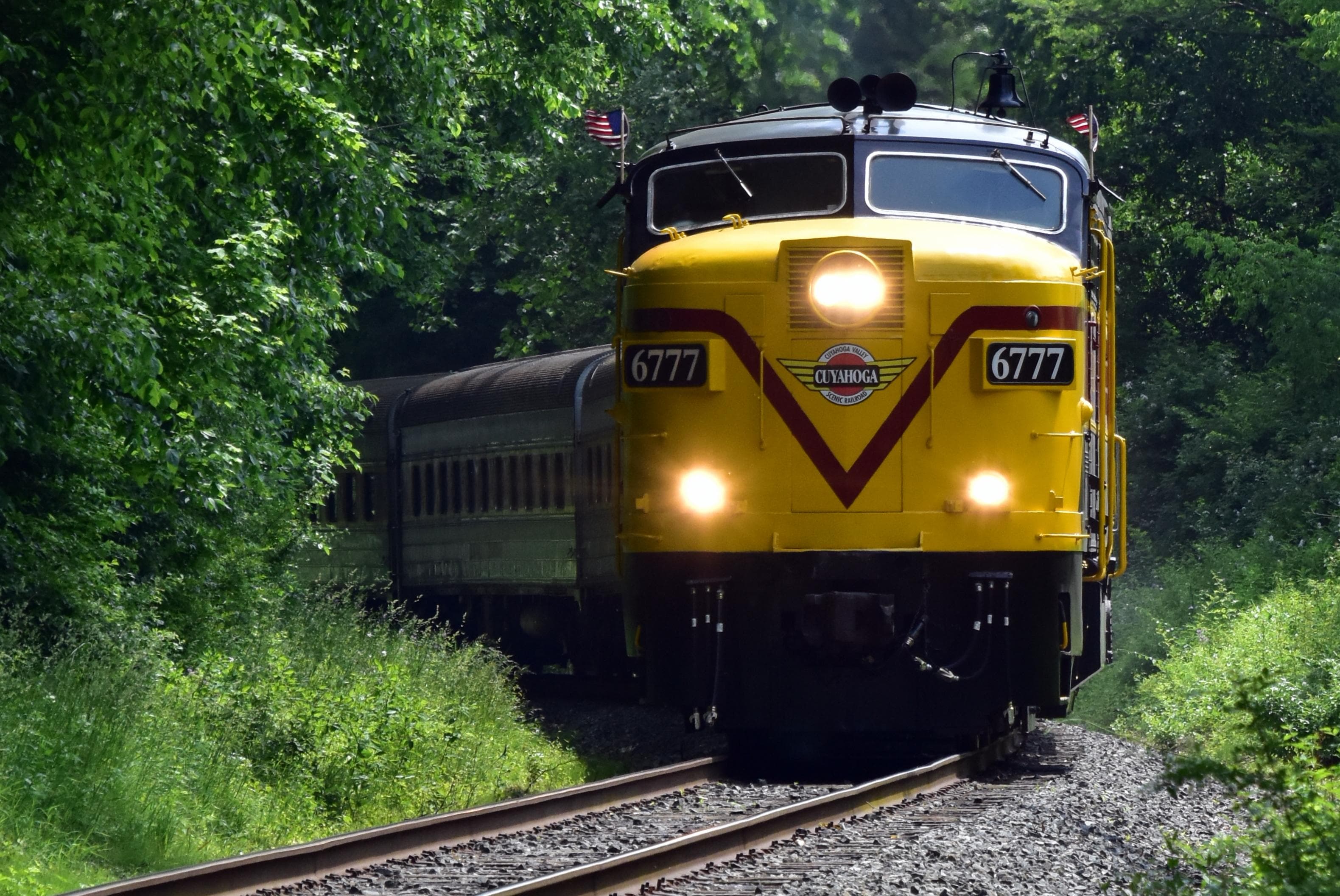
Akron Northside Station
POIPassengers in the Akron area can catch Cuyahoga Valley Scenic Railroad at Akron Northside Station. The station has ample parking and is a primary starting point for train excursions and events into the national park. The station is on a bus line and within walking distance of shopping, dining, and the Towpath Trail.
Alexander-Wilson Mill
POIAcross the canal is a historic mill. Up until 1970, it used waterpower to grind grain. The mill has been operated by two different families through several generations. It is now a feed store with pre-bagged grain.
Bath Road Heronry
POIThe Bath Road Heronry is a pull off along Bath Road, with exhibit panels telling about these prehistoric birds. Unique in that you can see and hear these birds without ever leaving the car!
Beaver Marsh, North Boardwalk
POIThis is one of three exhibits along the boardwalk at Beaver Marsh, a popular location for wildlife watching in Cuyahoga Valley. Use the flipbook to help identify and observe mammals and birds.
Beaver Marsh Viewing Platform
POIThe Ohio & Erie Canal Towpath Trail becomes a boardwalk through the Beaver Marsh, immersing you in the wetlands. A viewing platform oriented towards the west has two exhibits that invite you to explore the marsh. A Superior Wetland describes the different types of wetland communities within the marsh. Reptiles and Amphibians introduces the turtles, snakes, and frogs that make the marsh their home.
Boston Mill Station
POIBoston Mill Station is a Cuyahoga Valley Scenic Railroad flag stop. Passengers can get off the train to visit Boston Mill Visitor Center, the pedestrian friendly village of Boston, and nearby trails. Bicyclists, runners, hikers, and paddlers can access the train’s one-way shuttle service to create a trail-train adventure.
Boston Run Trailhead Information
POIThe far corner of the main parking lot for Happy Days Lodge provides access to Boston Run Trail. This 3.1-mile loop explores the woods and ravines along a headwater stream of the Cuyahoga River.
Boston Store Trailhead
POIThe Village of Boston grew up alongside a canal on the east side of the Cuyahoga River and a railroad on the west side of the river. Boston Store Trailhead provides limited mobility parking on the east side. Use it to access the Ohio & Erie Canal Towpath Trail and refreshments at Boston Store. This small trailhead does not accommodate over-sized vehicles.
Boston Store Trailhead River Access
POIAccess the river from Boston Store Trailhead in the Village of Boston. Boston Mill Visitor Center is nearby.
Boston Street View Panel
POIBoston boomed with the arrival of the Ohio & Erie Canal in 1827. It boomed again when a paper mill, the Cleveland Akron Bag Company, opened in 1902. This exhibit shows an early 1900s view of Boston Mills Road when the bag company dominated the town.
Boston Trailhead
POIThe Village of Boston is a crossroads for hikers, cyclists, runners, paddlers, and horse riders. Boston Trailhead provides parking for the Ohio & Erie Canal Towpath, Valley, and Buckeye trails. Paddlers may park their vehicles at the trailhead after unloading equipment at the Cuyahoga River Water Trail drop-off. Horse trailers are permitted. However, the parking lot was not designed to accommodate them, and it can be a challenge to navigate.
Boston Village Exhibits
POIExplore how Boston boomed during the canal era at this outdoor interpretive display. Boston’s success came in part from its role in boat building. Exhibits feature Boston’s boatyards, the basics of canal boat building, and other canal era businesses. A play structure provides a hands-on canal boat experience.
Botzum Station
POIPassengers using Cuyahoga Valley Scenic Railroad’s shuttle service for bicyclists, runners, and hikers can get on and off the train at Botzum Station. This station is located near the southern edge of Cuyahoga Valley National Park adjacent to the Towpath Trail. Botzum Trailhead offers ample parking nearby.
Botzum Trailhead Information
POIBotzum Trailhead is a large parking lot and the southernmost access to the Towpath Trail in Cuyahoga Valley National Park. Named for a prominent settler, Botzum was part of a string of communities that grew up along the canal and railroad. This section of the towpath attracts exercise enthusiasts. It is 2.5 miles north to Beaver Marsh to view wildlife. Head south through a commercial district. The towpath intersects Cascade Valley and Sand Run metro parks in 2.5 miles.
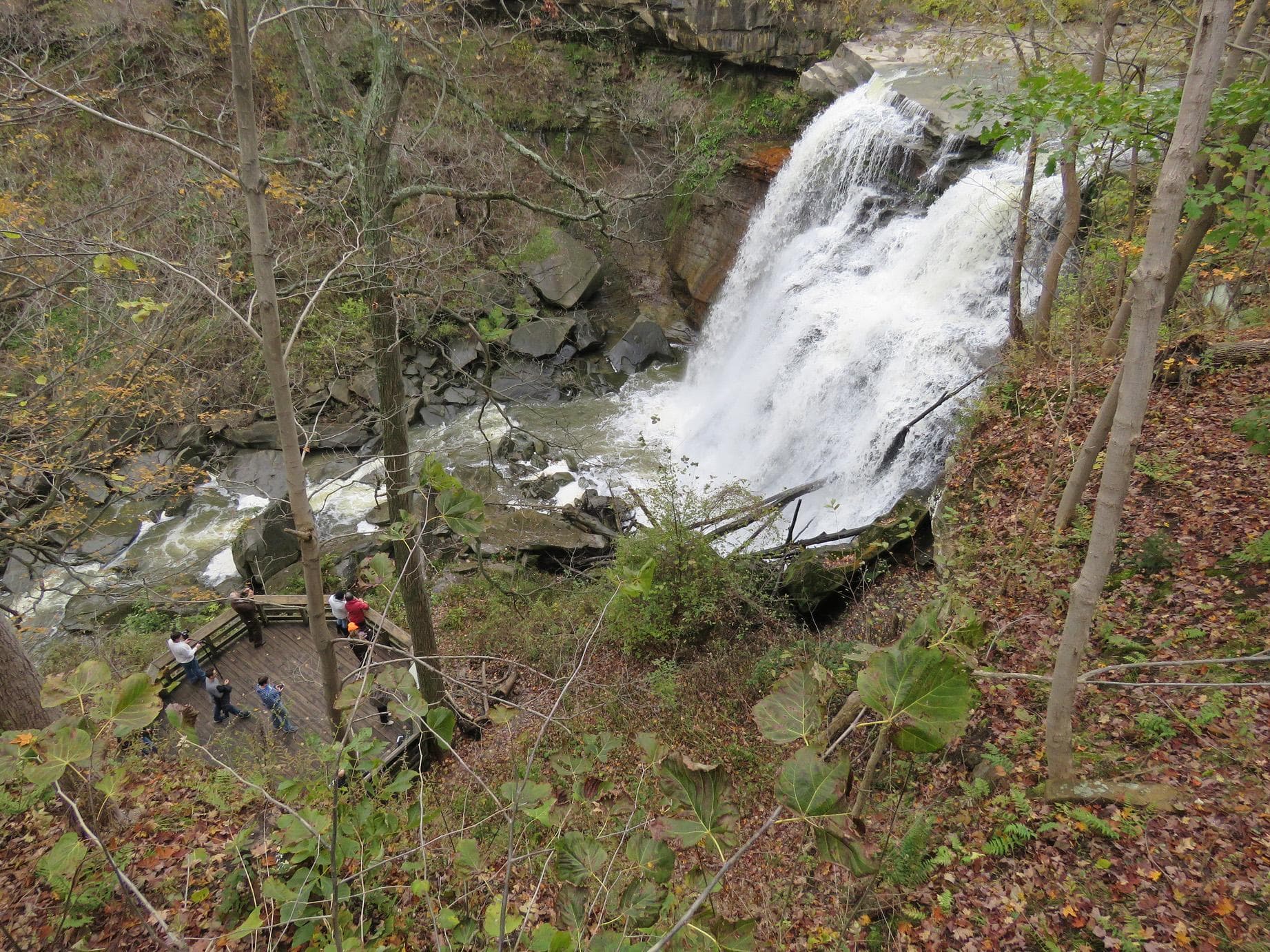
Brandywine Falls Trailhead Information
POIExplore the power and beauty of the 60-foot Brandywine Falls from this location. Extend your visit by walking the 1.4-mile Brandywine Gorge Loop or 1.5-mile Stanford Trail. The trailhead also provides access to Summit Metro Parks’ Bike & Hike Trail.
Brecksville Station
POIBrecksville Station is a flag stop for Cuyahoga Valley Scenic Railroad. It is located at Station Road Bridge Trailhead, which offers ample parking. Passengers can get on and off the train as part of combination trail-train adventure. The train provides a one-way shuttle service for bicyclists, runners, hikers, and paddlers using the Towpath, Buckeye, or Cuyahoga River Water trails.
Canal Exploration Center Station
POIPassengers riding Cuyahoga Valley Scenic Railroad can get on and off to visit Canal Exploration Center and travel along the Towpath Trail.
Canal Exploration Center Trailhead
POIStop by this information kiosk to learn what there is to do in the area around Canal Exploration Center.
Carved In Stone Panel
POIThese stairs blend well into the Ledges rock. The National Park Service has long credited the Civilian Conservation Corps (CCC) as their builder. The CCC famously used local resources in ways that fit in the landscape. New evidence suggests stairs existed prior to the CCC. The Plain Dealer published an article about the Ledges in 1906 with a photo of very similar stairs. Mr. Thompson owned a nearby farm. Future research might answer whether he built the original stairs.
Cuyahoga River and Prehistoric People
POIExplore the role the Cuyahoga River played in past Native American societies, both for transportation and as a food source.
Cuyahoga’s Floodplain Panel
POIThis convenient resting spot with a bench provides a scenic overlook of the Cuyahoga River. It is along the Ohio & Erie Canal Towpath Trail just north of Beaver Marsh. Explore what makes a river healthy through the exhibit panel and enjoy the view.
Deep Lock Quarry Panel
POIDeep Lock Quarry once supplied Berea sandstone for the Ohio & Erie Canal and other construction projects. It also produced grindstones, pulp stones, and millstones that were shipped locally and around the world. Follow a connector off the Towpath Trail to explore this Summit Metro Park in Peninsula.
Everett Covered Bridge
POIAn exhibit here tells the story of once common covered bridges. The Everett Covered Bridge is the last covered bridge remaining in Summit County. Through the years, covered bridges were replaced by iron bridges, much like horses were replaced by iron machines.
Everett Covered Bridge Trailhead Information
POIFor almost a century, the original Everett Covered Bridge provided safe crossing over Furnace Run. Today’s bridge was reconstructed after a 1975 flood. The trailhead provides access to the bridge and nearby trails. The 5.6-mile Riding Run Trail is open to pedestrians and horses. The 1.9-mile Furnace Run Trail is a walking trail popular for viewing spring wildflowers.
Frazee House Panel
POIExplore the architecture of the Frazee House. The Frazees were a Western Reserve pioneer family who became successful during the canal era.
Frazee House Towpath Panel
POIFrom the Towpath Trail, gaze across the canal to the Frazee House, built with handmade bricks in 1825-27. It still dominates the landscape, much as it did during the canal era.
Gleason Farm Panel
POIView the historic Gleason Farm as you travel the Towpath Trail. It remains a working farm, part of the park’s Countryside Initiative program.
Greenwood Village: Fort or Sacred Site?
POIThe earthworks near this site were initially considered a fort, but archeologists now consider them to be more of a ceremonial site. Exhibits explain the history of the archeology here and why the purpose has been reconsidered. The area is accessible via the Old Carriage/Bike & Hike Connector Trail, with the Bike & Hike Trail uphill from the connector and the Towpath Trail downhill in the valley from this location.
Greenwood Village: Prehistoric Earthwork
POINative Americans have left their marks on the land for thousands of years. Learn more about the earthworks along the Old Carriage Trail. The area is accessible via the Old Carriage/Bike & Hike Connector Trail, with the Bike & Hike Trail uphill from the connector and the Towpath Trail downhill in the valley from this location.
Happy Days Historic Sign
POIA large sign marks the path to Happy Days Lodge. The Civilian Conservation Corps built Happy Days Lodge during the Great Depression in the 1930s. It was part of their effort to develop park amenities for Virginia Kendall Park, now part of Cuyahoga Valley National Park. Haskell Run Trail starts behind Happy Days Lodge and connects to additional Virginia Kendall Park trails.
Happy Days Lodge
POIThe men of the Civilian Conservation Corps built Happy Days Lodge during the difficult years of the Great Depression. They used manual labor and local materials, including Berea Sandstone and wormy American chestnut. For years, it served as a camp for children from the City of Akron. Today, it is a rental facility and program space managed by the Conservancy for Cuyahoga Valley National Park.
Haskell Run Trailhead Information
POIThe Haskell Run Trail is a ½-mile loop trail that explores a creek that feeds the Cuyahoga River. The creek’s deep, wooded ravine attracts abundant birdlife. Visit in April and May to enjoy spring wildflowers. The trail also connects Happy Days Lodge with the Ledges area.
Horseshoe Pond Trailhead Information
POIThe Horseshoe Pond area was once part of the historic Bishop Farm. By the second half of the 1900s, the Bishops were planting and selling Christmas trees. Take the Tree Farm Trail to see how nature is reclaiming these old fields.
Hunt House and Outdoor Exhibits
POI“Growing Up in Everett” exhibits explore farm life in the 1920s and 1930s through the eyes of Helen Fiedler Toth. Listen to her stories, flip through her photo album, and play with her calf and chickens.
Hunt House Trailhead
POIHunt House is in the Village of Everett, a type of rural crossroads community that was once common across America. Family-friendly exhibits at Hunt House explore village life and the lives of wild plants and animals. From Hunt House continue a quarter mile north to Lock 27 for another peek into the crossroads community. Beaver Marsh, popular for wildlife watching, is three-quarters of a mile south.
Indigo Lake Station
POICuyahoga Valley Scenic Railroad passengers can get on and off the train at Indigo Lake Station. Connector trails lead west to Hale Farm & Village and east to the Towpath Trail. The railroad coordinates a shuttle ride to Hale Farm & Village with select train excursions. Nearby parking is limited.
Ira Trailhead Exhibits
POIAn exhibit cluster shares the remarkable story of nature’s recovery at Beaver Marsh, located a quarter mile to the north. Beavers and humans transformed a former auto salvage yard into a 70-acre wetland in the 1980s. Hands-on beaver, river otter, and muskrat sculptures introduce three mammals that depend on the marsh for their survival.
Ira Trailhead Information
POIThis trailhead is popular for accessing the Beaver Marsh, located a half mile to the north on the Towpath Trail. The story of the Beaver Marsh has many chapters: a dairy farm, an auto salvage yard, and now a popular spot for viewing the wildlife, plants, and scenery of a recovering marshland.
Kendall Lake Pier and Shelter
POIThe Kendall Lake Pier was built by the Civilian Conservation Corps and originally served as a swimming pier. Today it serves as a fishing pier, a photography point, and a place to relax and enjoy nature.
Kendall Lake Trailhead Information
POIThe Kendall Lake is one of the many amenities the Civilian Conservation Corps built in the Virginia Kendall Park. A one-mile trail loops around Kendall Lake. The Cross Country and Salt Run trails can also be accessed from this location.
Ledges Overlook
POIThe Ledges Overlook provides an expansive view of the Cuyahoga Valley. From here, visitors can appreciate how the park protects a large tract of natural open space between the cities of Akron and Cleveland. The scenery is stunning in any season.
Ledges Shelter and Exhibits
POIThe Ledges Shelter is the largest Civilian Conservation Corps shelter in Cuyahoga Valley National Park. Groups and families with up to 75 people may reserve it for a fee.
Ledges Trailhead Information
POIThe striking rock cliffs of the Ledges are a primary feature of Virginia Kendall Park, developed in the 1930s. Use this trailhead to access a 1.8-mile trail that circles the Ledges, a rentable shelter, a giant grassy playfield, and many wooded picnic sites.
Lock 24
POIThe one remaining wall of Lock 24 is a reminder of the lost village that once thrived nearby. During the 1800s, traffic along the Ohio & Erie Canal and later the Valley Railway supported local businesses. The community at the Bath Road intersection became known as Botzum.
Lock 25
POILocks along the Ohio & Erie Canal usually had associated businesses or farms. The remnants of Lock 25 are close to the historic Botzum Farm. The farm was established by a large family of German immigrants.
Lock 26
POILock 26 was one of 44 locks that let canal boats step up from Lake Erie to the 968-foot-high Portage Summit in Akron. The Carter family lived nearby and had a dairy farm in addition to working on the Ohio & Erie Canal. Here in the Cuyahoga Valley, dairy farming was common, and the area became known as “cheesedom.” An exhibit at Lock 26 explores the Carter family story and local cheesemaking.
Lock 28
POILock 28 is called Deep Lock because it was the deepest lock along the Ohio & Erie Canal. It had a 14-foot lift, while most locks had an eight-foot one. Boatmen and engineers soon figured out that locks this deep took a lot of water. Often this lock took twice as long to fill or drain.
Lock 29
POILock 29 in Peninsula was an unusual lock with canal bends at both ends and an aqueduct. This combination created a bottleneck for traffic on the Ohio & Erie Canal. View the lock from inside or above, exploring this feat of engineering.
Lock 29 Inside Exhibits
POICanal locks are engineering feats that were needed wherever the land rose or fell significantly. Lock 29 was doubly so, built between an aqueduct and bends in the canal. The tactile exhibits inside explain how the canal was built and how the lock operated.
Lock 29 River Access
POIAccess the river from the Lock 29 Trailhead parking lot in Peninsula. Peninsula Depot and food are nearby.
Lock 29 Trailhead Information
POIThe Ohio & Erie Canal made Peninsula a busy industrial town and popular overnight stop for canal travelers. Today visitors can stroll through the historic downtown, shop, and dine. Lock 29 Trailhead is a popular, often crowded access point for the village, Towpath Trail, Cuyahoga Valley Scenic Railroad, and Cuyahoga River Water Trail. On the towpath, travel 2.3 miles north to the village of Boston. About a mile south is Deep Lock and connecting trails to old stone quarries.
Lock 31
POILocks along the Ohio & Erie Canal were assigned numbers, but also gained nicknames. Lock 31 became known as Lonesome Lock.
Lock 32
POILock 32 was one of 44 locks on the Ohio & Erie Canal between Lake Erie in Cleveland and the Portage Summit in Akron. Historically, McBride’s Grocery served canallers at Lock 32.
Lock 35
POIRead about the “laughter and tears” of the Murphy family who once had a farm at Lock 35.
Lock 36
POIBy the remains of Lock 36, visitors can explore the Pinery Feeder which still “feeds” water from the Cuyahoga River into this section of the Ohio & Erie Canal.
Lock 37 and Flood Gate
POILock 37 was once a busy location with a tavern, mill and floodgate. A small parking lot on nearby Fitzwater Road provides access to the Towpath Trail.
Lock 38 at Canal Exploration Center
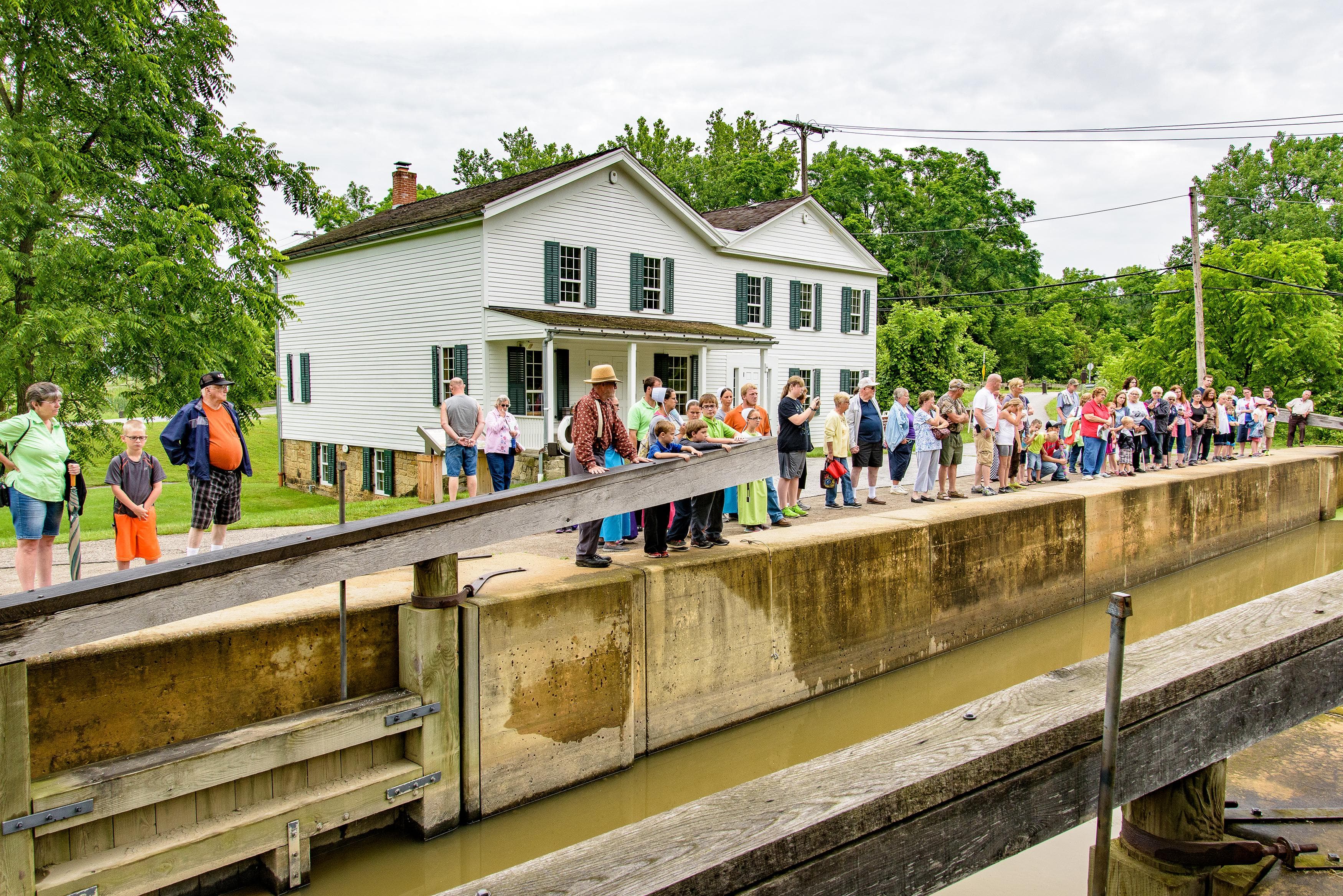
POIWhat is a canal lock? Stop here to learn about the mechanics of these boat elevators. If you are lucky to have water in the canal on a summer weekend, you might see volunteers demonstrating how Lock 38 works.
Lock 39
POILock 39 is the northernmost lock in Cuyahoga Valley National Park. It is one of many canal remnants you can see as you walk, ride, or run along the Towpath Trail.
Lock 39 River Access
POIAccess the river from the Lock 39 Trailhead in Independence. This site allows access for a long paddle, nearly 12 miles, into Cleveland. Rockside Station and food are nearby.
Lock 39 Trailhead Information
POIThis is the northernmost trailhead within Cuyahoga Valley. From here, visitors can explore the Towpath Trail south into the national park or north into Cleveland Metroparks. Across the parking lot is an access point for the Cuyahoga River Water Trail and a pedestrian bridge to Rockside Station.
Moody and Thomas Mill Site
POIFalling water once provided power to grind grain into flour. Hermon Bronson built a grist mill here in 1832, conveniently located on the new Ohio & Erie Canal. Today the mill race and crumbling foundation are all that remain.
Mudcatcher
POIAcross the canal here, visitors can see the manmade Mudcatcher Falls. The stone abutment was built to hold back soil and debris from entering the canal. From this vantage point, visitors can travel north or south on the Towpath. To the north, in less than a tenth of a mile, the Valley horse trail will veer off to the left. In early spring, visitors may be lucky enough to see a bald eagle from this trail.
Mule Power Panel and Statue
POIWe can easily forget that America was once powered by animals, not by machines. Explore why mules were the preferred animal for pulling boats along the canal, as you meet “Blossom” the bronze mule.
Northampton Point River Access
POIAccess the river via Northampton Point in Cuyahoga Falls. A path leads west from the parking lot to the river.
Oak Hill Trailhead
POIThe Oak Hill area is a favored area for birding, running, hiking, fishing, photography, and cross country skiing. Once farmed, the area is now returning to forest. Two trails intertwine here – the shorter 1.8-mile Oak Hill and the longer 5-mile Plateau trail. They skirt farm ponds and deep ravines.
Octagon Shelter and Exhibits
POIThe Octagon Shelter is a great example of a style of architecture that came to be known as “parkitecture.” This type of architecture fit well into the natural landscape. It became synonymous with Civilian Conservation Corps structures. Groups and families with up to 50 people may reserve it for a fee.
Ohio and Erie Canalway National Heritage Area
POIThe Ohio and Erie Canalway National Heritage Area spurred economic development across the nation by creating an inland connection for goods from Lake Erie to the Ohio River, known as the heartland of America to the eastern seaboard. This development fueled westward expansion, a national market economy, a booming industrial manufacturing sector, and the settlement of towns, villages, and cities along the canal.
Ohio's Lake Placid Panel
POIThe Civilian Conservation Corps built many outdoor recreation amenities, including toboggan chutes. Here an exhibit examines the last chutes that once stood here, providing winter fun for some 40 years.
Old Canal Bed Panel
POIPause on this footbridge to gaze into the bed of the historic Ohio & Erie Canal. Nature is reclaiming this built waterway. Observe how a seasonal stream is carving its way down the valley walls to the Cuyahoga River. From here, continue on the flat Towpath Trail or head uphill to the Old Carriage Trail and the Bike & Hike Trail.
Peninsula Depot
POIThe Peninsula Depot is an original station from the historic Valley Railway. Today it serves as a ticketing office and boarding location for the Cuyahoga Valley Scenic Railroad.
Pilgerruh Panel
POIPilgerruh means “pilgrim’s rest.” From 1786-87, Christian Lenape and Moravian missionaries sought refuge near Tinkers Creek.
Pine Grove Trailhead Information
POIAccess two of the interconnected trails in Virginia Kendall Park from the Pine Grove Trailhead. The 1.8-mile Ledges Trail circles around a sandstone outcrop with towering cliffs. The 2.2-mile Pine Grove Trail wanders through areas with planted pine trees and along the edge of wooded ravines. Both trails are relatively flat with uneven surfaces.
Pine Hollow Trailhead Information
POIThe Pine Hollow Trailhead, with its plentiful parking, sits at the top of the Kendall Hills. The location offers scenic views, a popular sledding destination, and year-round trail access. From here you can access the Salt Run or Wetmore trails, or follow connectors to the Lake and Cross Country trails.
Pine Lane Trailhead Information
POIPine Lane Trailhead provides access to two of the longest trails that pass through the national park: the Buckeye and the Valley. This is a good starting point for hikers and runners who want to avoid the crowds and challenge themselves with hills.
Pinery Feeder
POIHow do you restore a river? When two historic dams were removed at this site in 2020, the Cuyahoga became free flowing here for the first time in nearly 200 years. Learn more and find out the new method for diverting river water into the Ohio & Erie Canal via the Pinery Feeder.
Red Lock Trailhead
POIThe Red Lock Trailhead area is a place to observe how nature is reclaiming old industrial sites and canal ruins. The small trailhead provides access to the Ohio & Erie Canal Towpath Trail, Valley Trail, and Cuyahoga River Water Trail. The area is a hotspot for birding, especially during spring migration. About a half-mile south on the towpath is the site of the Jaite Paper Mill, once a large employer in Cuyahoga Valley.
Red Lock Trailhead River Access
POIAccess the river from the south side of the Vaughn Road bridge over the Cuyahoga River. This bridge is located near Red Lock Trailhead in Sagamore Hills.
Restoring the Cuyahoga River Exhibits
POINear the Station Road Bridge Trailhead, several exhibits tell the Cuyahoga’s remarkable story of recovery. Wildlife is returning to a river famous for catching fire. Listen and read how local people made this happen. Pose for photos with our eagle and heron statues.
Ritchie Ledges Panel
POIThe Ledges create a high point in the valley uplands. Learn the basics of their geology at the Ritchie Ledges wayside. It describes how periodically fast-moving streams flowed through a steamy swamp about 315-320 million years ago. The streams brought sand and pebbles that formed the Sharon Sandstone and Conglomerate rock that we see today.
Rockside Station
POIPassengers in the Cleveland area can catch the Cuyahoga Valley Scenic Railroad at Rockside Station. This also provides overflow parking for visitors accessing the Towpath Trail and the Cuyahoga River Water Trail at Lock 39 Trailhead. The station has ample parking and is a primary starting point for train excursions and events.
South Park Exhibits
POISouth Park Village was on a bluff across the river from these exhibits. Prehistoric people of the Whittlesey Tradition lived here from 1000 to 1600.
Stanford House
POIBuilt in 1843 by George Stanford, the Stanford House offers accommodations to groups and visitors through the Conservancy for Cuyahoga Valley National Park.
Stanford Trailhead
POIStanford Trailhead is a parking area for the Towpath, Valley, and Stanford trails.The trailhead includes standard parking spaces as well as 7 horse trailer spaces with 5 hitching posts. From here, a 1.5-mile trail leads up the side of the valley to Brandywine Falls.
Station Road Bridge Exhibits
POIThe wrought-iron Station Road Bridge was built over the Cuyahoga River in 1881. It provided vehicle access to the Cuyahoga Valley Line at Brecksville Station. This train station and its bridge were a vital link between Cuyahoga and Summit counties, improving travel between Cleveland and Akron. Today, the bridge serves hikers, horseback riders, and cyclists. Two exhibit panels interpret the Pinery Narrows bridges and the Cuyahoga River.
Station Road Bridge River Access
POIAccess the river via the Station Road Bridge Trailhead in Brecksville. A mowed path leads from the southeast corner of the parking lot to the river.
Station Road Bridge Trailhead Information
POIBrecksville Station was once a loading point for outgoing milk and lumber on the Valley Railway. Now this area is a crossroads for rail passengers, hikers, cyclists, runners, paddlers, and horse riders. Here, Station Road Bridge Trailhead provides ample parking and access to the Towpath Trail, Cuyahoga River Water Trail, and Cuyahoga Valley Scenic Railroad. In spring and summer, this is a hotspot for birders who flock to see cerulean and yellow-throated warblers.
Stumpy Basin
POIToday, Stumpy Basin is a wetland that includes diverse plant communities. Visitors can travel through the area on the Ohio & Erie Canal Towpath Trail which becomes a boardwalk here. Historically, basins were wide spots on the canal where boats could turn around or park. Now visitors can pull out on wider spots on the boardwalk to observe the plants and wildlife.
Tavern and Store Panel
POICanal Exploration Center was once a rest stop on the Ohio & Erie Canal. The Gleasons ran a tavern and a store in this building in the mid-1800s.
Tinkers Creek Aqueduct
POIWhy is there a bridge for water? This aqueduct carries the Ohio & Erie Canal over Tinkers Creek.
Village and River Linked Panel
POIHere, at this sharp bend of the Cuyahoga River, lies the heart of Peninsula’s story, shaped by water. This history features the Ohio & Erie Canal, the former Valley Railway, and the remains of an old riverbend that gave the village its name.
Waste Weir
POIThe remains found here are called a waste weir, where excess water could drain off the canal. The canal was a regulated 4 feet deep and too much water could do as much damage as too little water.
Welcome to Peninsula Panel
POIThis exhibit is on the outside of the Peninsula public restrooms. It helps orient people to the village, Towpath Trail, and scenic railroad.
Wetmore Trailhead Information
POIWetmore Trailhead offers many choices for exercise and exploration in a less crowded part of the park. Horseback riders and hikers share the five interconnected trails. From here, you can also connect to Kendall Lake and Everett Covered Bridge area trails.
William McKinley Tomb
POIThis large circular, domed mausoleum is the final resting place of William McKinley, the 25th president of the United States. McKinley was born in Niles, Ohio but he called Canton home throughout his adult life. He began his career in this city, met his beloved wife, and ran for the highest office of the nation here. His election in 1896 launched an era of Republican dominance that continued until 1910. McKinley governed during a period of intense American expansionism.
You Are Here: Poetry in Parks at Ledges Trailhead
POIA picnic table near the Ledges Trailhead features a poem by Jean Valentine selected by the 24th U.S. Poet Laureate, Ada Limón as part of her signature project "You Are Here: Poetry in Parks."
Things to do
Become a Cuyahoga Valley Junior Ranger
Learn how kids ages 3 and older can become Junior Rangers of Cuyahoga Valley National Park.
Duration: 1-3 Hours
Find Spring Wildflowers in Cuyahoga Valley
Searching for wildflowers is a great way to connect with nature and stay active in spring. Discover what’s blooming along park trails.
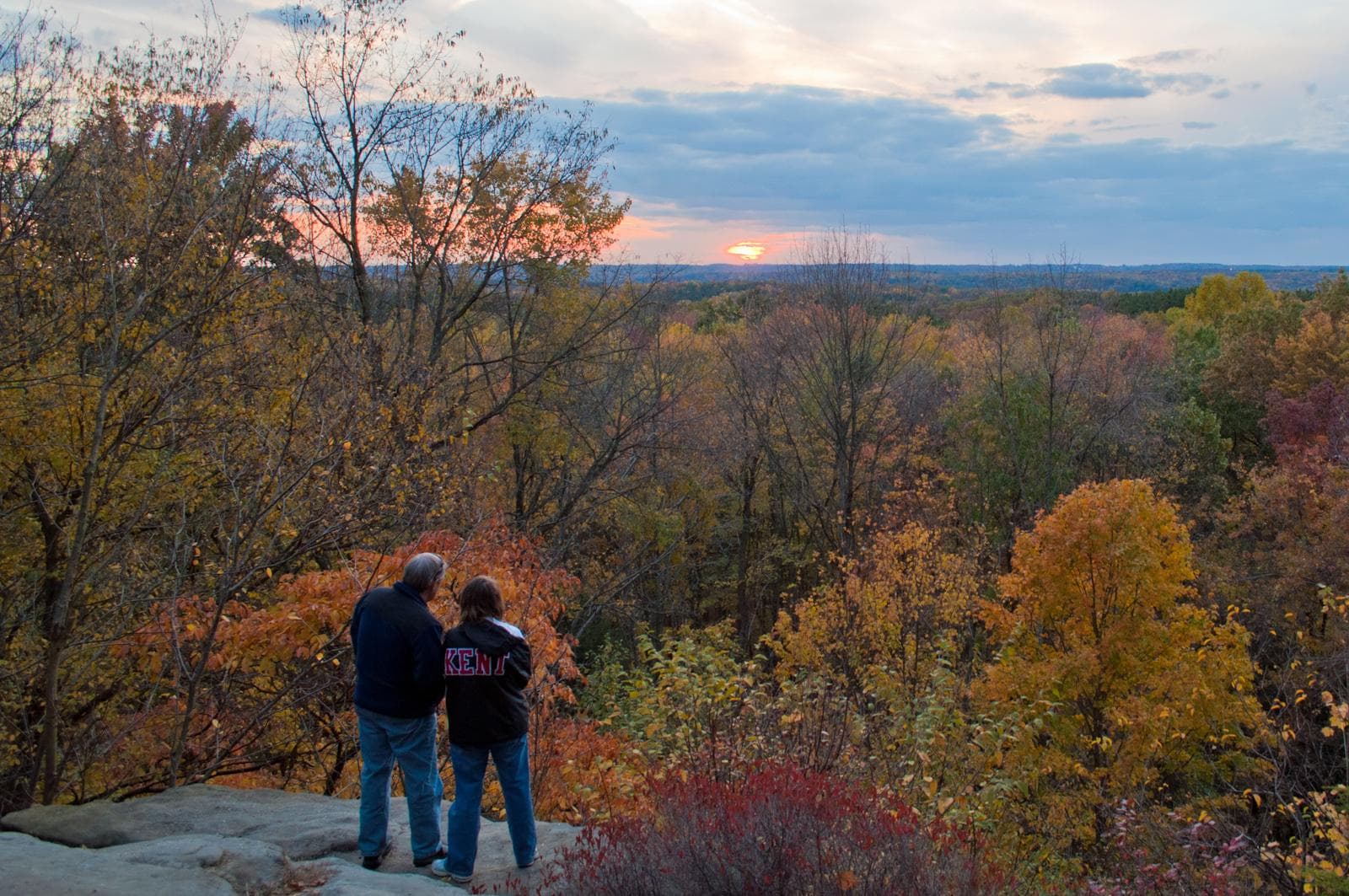
Find the Best Fall Colors in Cuyahoga Valley
Leaf peepers, grab your cameras! Here are our tips for where to find Cuyahoga Valley’s best fall colors throughout October.
Go Birding in the Cuyahoga Valley
Birding is a popular activity at Cuyahoga Valley National Park. Thanks to the park’s wide variety of habitats, it is possible to observe more than 200 bird species throughout the year. Grab a field guide and a pair of binoculars and see what awaits your discovery.
Go Fishing in the Cuyahoga Valley
Fishing is a great way to spend your day in Cuyahoga Valley National Park. Learn about the best places to fish and how to responsibly enjoy this pastime.
Go Mountain Biking in Cuyahoga Valley
The East Rim Trail system has stunning views, varied terrain, exciting obstacles, and an element of adventure for intermediate mountain bikers.
Duration: 20-60 Minutes
Go Snowshoeing in the Cuyahoga Valley
Snowshoeing is a great way to explore and exercise in Cuyahoga Valley National Park when the conditions are right. We recommend waiting for there to be at least four inches of packed snow on the trail.
Hike the Brandywine Gorge Loop
The Brandywine Gorge Loop circles a deep ravine carved by Brandywine Creek, and provides stunning views of Brandywine Falls along the way. Learn more about hiking this popular trail.
Duration: 1-2 Hours
Hike the Ledges Trail
The Ledges Trail circles a plateau of striking rock formations and provides stunning views along the way. Learn more about hiking this popular trail.
Duration: 1-2 Hours
Hike to Blue Hen Falls from Boston
Blue Hen Falls is a popular hike-in destination in the Boston area. Hikers can reach the waterfall via the Buckeye Trail from Boston Mill Visitor Center. Learn more about this popular hilly hike.
Duration: 1-2 Hours
Kid- and Autism-friendly Activities in the Everett Area
Three short walks in the Everett area offer sensory activities that appeal to children or individuals with autism. They include tactile and audio exhibits.
Duration: 1-3 Hours
Let's Go Canalway Questing
Put your detective hat on! Quests are fun, self-guides hikes that help you explore the Ohio & Erie Canalway. Follow rhyming clues to hidden boxes. Sign the logbook and collect impressions of each hand-carved stamp.
Duration: 30-75 Minutes
Plan Your Event at Cuyahoga Valley
Find out how you can host an event in the park.
Ride the Cuyahoga Valley Scenic Railroad
All aboard the Cuyahoga Valley Scenic Railroad! Learn more about this unique way to experience Cuyahoga Valley National Park.
Short Towpath Trail Walks
These short walks along the Towpath Trail explore many highlights of the valley’s lowlands. They are recommended for people who have mobility disabilities, are visiting with children, or have limited time.
Duration: 30-60 Minutes
Stop by Boston Mill Visitor Center
Begin your adventure at Boston Mill Visitor Center. Pick up maps and shop for souvenirs. Staff and volunteers are available to help you plan a visit that fits your time and interests.
Visit Canal Exploration Center
Arrive by car, bike, or scenic railroad. Hands-on exhibits at this historic tavern and store bring the canal era to life. Lock demonstrations are offered seasonally. From here, you can stroll the Towpath Trail.
Duration: 30-120 Minutes
Visit Cuyahoga Valley Farms and Markets
Agriculture has long been an important part of life in the Cuyahoga Valley. Today, there are eight farms that operate within the national park. Several have roadside stands or host events throughout the year. Learn more about these farms and about weekly farmers markets in and around the park.
Visitor centers
Boston Mill Visitor Center
Start your visit to Cuyahoga Valley National Park at Boston Mill Visitor Center. Meet park staff, get questions answered, and learn about the park and places to visit. The visitor center is open daily from 9:30 am to 5 pm, March through December. January and February, hours are shortened. For the summer season, hours are extended and additional staff are available outside the visitor center to assist with trip planning, weather permitting. Restrooms stay open even when the visitor center is closed.
Get directionsCanal Exploration Center
Discover the Ohio & Erie Canal in the storied Canal Exploration Center that was once used as a tavern, a general store, a residence, and a park visitor center. Find out how the canal shaped the nation through in-depth, interactive Canal Era exhibits for children and adults. Restrooms at the trailhead stay open even when Canal Exploration Center is closed.
Get directionsHunt House
Hunt House offers child-friendly nature exhibits, a rest area along the Towpath Trail, and information about nearby attractions. Hunt House is open seasonally as staffing allows. Restrooms stay open even when Hunt House is closed.
Get directions
Hours of operation
Cuyahoga Valley National Park
Cuyahoga Valley National Park is open everyday, 24 hours a day with the following exceptions: Brandywine Falls, Ledges, Octagon, Kendall Lake, and Kendall Hills close from dusk until morning opening.
Mon
All Day
Tue
All Day
Wed
All Day
Thu
All Day
Fri
All Day
Sat
All Day
Sun
All Day
Activities
Weather
Spring's rain and warming temperatures bring new leaves on trees, blooming wildflowers, and visitors anxious to get out on the trail. Summer temperatures range from 49 to 95 degrees F and can be humid. Dressing in layers is advisable. Fall temperatures can range from low 70s during the day to freezing during the night. Fall foliage often peaks in mid-October. Winter weather conditions can rapidly change due to the lake effect snow from Lake Erie. Temperatures vary from mid-30s to below zero.
Contact
Photos
Stay near this park
No horse-friendly stays listed near Cuyahoga Valley National Park yet. Know a great barn or property? Help fellow riders by listing it.
List your propertyDirections
The park is easily accessible by car from all directions. A good place to start your visit is at Boston Mill Visitor Center: 6947 Riverview Road, Peninsula, 44264. Cleveland Hopkins International Airport and Akron-Canton Regional Airport offer many daily flights to the area. Car rentals are available at both airports. Bus stations are located in downtown Cleveland and Akron. Some local bus routes including RTA's 19A, 54, 77, and 90 routes stop near the park. There is an Amtrak station in downtown Cleveland.
Source: nps.gov