
Park Closure
Battery 234 Loop Road Closure
The Battery 234 Loop Road and Battery Cooper within the GUIS, Fort Pickens Management Area will be closed to all for vehicle, bicyclists, and foot (pedestrian) traffic until further notice for safety purposes until the park can correct the leaning and structurally unstable historic Tower 234 that poses danger to visitors and staff. The beach access points for pedestrians from the Gulf (south) side will also be closed. The pipe gates at the entrance and exit points will be locked with accompanied signage.
More infoCaution
Road workers on Park Road in Davis Bayou
Phase II of the Davis Bayou Bicycle and Pedestrian Path is in process. Visitors may encounter minor traffic delays and flaggers on Eagle Point and Park Road.
More infoInformation
Accessing Fort Barrancas
Fort Barrancas is open 9 am–4 pm Wednesday through Sunday. To access Fort Barrancas, visitors will need to enter the Naval Air station Pensacola through the west gate.
More infoInformation
No Dogs on Beach
Dogs and pets are not allowed on any of the beaches in Gulf Islands National Seashore. Visit the pet rules page for information.
More infoGulf Islands National Seashore
FL · MS · Ocean Springs
Millions of visitors are drawn to the Gulf of America for Gulf Islands National Seashore's emerald coast waters, magnificent white beaches, fertile marshes and historical landscapes. Come explore with us today!
Riding guide
Highlights
Gulf Islands National Seashore protects a chain of barrier islands, coastal forests, historic forts, and marine habitats along…
Riding
Rideable terrain here is noted as 6 miles, giving riders a clearer sense of scale before they ever unload. For equestrians, this section of the park offers a small but unique riding environment within a maritime forest ecosystem overlooking Santa Rosa Sound. The trail system winds through shaded corridors of centuries-old live oak trees draped in Spanish moss, along with pine, magnolia, and palmetto vegetation typical of the Gulf Coast.
Rideable terrain
6 miles
Trailer parking
Naval Live Oaks Main Trailhead / Headquarters Parking Location: Near 1801 Gulf Breeze Parkway, Gulf Breeze, Florida, just north of U.S. Highway 98. Why riders use it • The central access point for the Naval Live Oaks trail system • Large paved and gravel parking areas used by hikers and trail users • Direct access to ~6–7 Miles of multi-use trails where horseback riding is permitted • Restrooms and picnic areas available nearby • Easy access from Highway 98 for vehicles pulling trailers. Naval Live Oaks Youth Campground / Pavilion Area Location: North side of U.S. Highway 98 within the Naval Live Oaks district. Why riders use it • Quieter staging area compared with the main trailhead • Open space near the group campground and pavilion • Direct access to several interior trails and fire roads • Often used by groups staging horses before rides. Trailhead Parking Along the North Gate Access Road Location: Small lots just inside the north entrance gate of the Naval Live Oaks trail system. Why riders use it • Convenient access to interior trails • Gravel pull-offs and small parking areas near trail junctions • Good starting points for loop rides through the live oak forest trails.
Horse regulations
Horseback riding at Gulf Islands National Seashore is permitted only in the Naval Live Oaks district and is managed to protect the coastal forest ecosystem. Several core regulations apply for riders in this area. Riding Areas Horses are permitted only on designated multi-use trails north of U.S. Highway 98 within the Naval Live Oaks Area. Horses are not allowed on beaches, barrier islands, swimming areas, or developed sections of the park. Trailer Parking Horse trailers should use the Naval Live Oaks trailhead parking areas near the park headquarters. Riders must avoid blocking roads or parking outside designated areas. Trail Courtesy Equestrian trails are shared with hikers, runners, and cyclists. Riders should: Maintain control of horses at all times Slow down when approaching other trail users Yield appropriately on narrow trails. Feed and Invasive Species Prevention To protect the coastal ecosystem, riders should: Use weed-free hay or feed when possible Ensure trailers and tack are clean before entering the park. Waste and Site Protection Manure and feed debris should be removed from parking areas to help maintain clean trailheads and prevent impacts to the park environment.
Getting here
Use 3500 Park Road, Ocean Springs, Mississippi as your primary planning reference before you haul in. Naval Live Oaks Main Trailhead / Headquarters Parking Location: Near 1801 Gulf Breeze Parkway, Gulf Breeze, Florida, just north of U.S. Highway 98. Why riders use it • The central access point for the Naval Live Oaks trail system • Large paved and gravel parking areas used by hikers and trail users • Direct access to ~6–7 Miles of multi-use trails where horseback riding is permitted • Restrooms and picnic areas available nearby • Easy access from Highway 98 for vehicles pulling trailers. Naval Live Oaks Youth Campground / Pavilion Area Location: North side of U.S. Highway 98 within the Naval Live Oaks district. Why riders use it • Quieter staging area compared with the main trailhead • Open space near the group campground and pavilion • Direct access to several interior trails and fire roads • Often used by groups staging horses before rides. Trailhead Parking Along the North Gate Access Road Location: Small lots just inside the north entrance gate of the Naval Live Oaks trail system. Why riders use it • Convenient access to interior trails • Gravel pull-offs and small parking areas near trail junctions • Good starting points for loop rides through the live oak forest trails.
Planning your visit
Riding Is Limited to One Area Despite the park’s large size, horseback riding is allowed only in the Naval Live Oaks district. Horses are not permitted on the beaches or barrier islands. Sandy Trail Surfaces The coastal soils are sandy and can become loose, particularly during dry periods. Horses unfamiliar with sand footing may need time to adjust. Heat and Humidity The Gulf Coast climate can be hot and humid for much of the year, especially during summer. Riders should bring adequate water for both horses and riders. Insects Mosquitoes and biting insects can be common in the maritime forest environment, particularly in warmer months. Shared Multi-Use Trails The Naval Live Oaks trail system is popular with hikers and cyclists, especially on weekends. Riders should expect regular encounters with other trail users. Short Trail Network Because the trail system is only about 6 Miles long, most rides are relatively short. Riders often repeat loops or combine routes to extend their ride.
Where to stay
Gulf Islands National Seashore Visitor Center is the main visitor-contact point tied to this destination, which is helpful when you want current conditions, maps, and stock-use updates before riding. This entry reads best as a bring-your-own-horse destination rather than a horse-rental stop, and amenities should be confirmed directly before travel. For a polished trip plan, pair the ride with lodging, fuel, and resupply planning in or near Ocean Springs before heading deeper into federal-land access points.
Entrance fees & passes
- $25.00
Entrance - Private Vehicle
Cost for up to six people in one vehicle. Good for seven days into any fee area in Florida, (Opal Beach, Johnson Beach, Fort Pickens).
- $20.00
Entrance - Motorcycle
Valid for 7 days. Admits up to 2 private, non-commercial motorcycles with up to 4 total passengers. Fees are required at Fort Pickens Area, Opal Beach Complex Area, and Johnson Beach Area in Florida. Additional fees to ride the ferry.
- $15.00
Entrance - Per Person
Fees are required at Fort Pickens Area, Opal Beach Complex Area, and Johnson Beach Area in Florida. Additional fees to ride the ferry.
- $45.00
Annual Entrance - Park
Good for 365 days from purchase. Non-replaceable if lost. Keep receipt as second proof of purchase. Design specific to the park and changes annually.
Park map
Trails
No trails synced for this park yet.
Campgrounds
Davis Bayou Campground
52 sites
Gulf Islands National Seashore's Davis Bayou Campground offers tent and recreational vehicle camping experiences in a wooded area next to Davis Bayou in Mississippi. Campground office hours are 8 am to 4 pm daily.
Reserve a siteDavis Bayou Group Campground
0 sites
The area is available with a permit for a minimum of 10 and a maximum of 40 occupants. Persons camping in the group area are limited to the restroom facilities located at pavilion #5. Parking is limited.
Fort Pickens Campground
200 sites
The Fort Pickens Campground is one of the top ten busiest campgrounds in all of the 430+ national parks and sites. Available all year round it provides access to white sandy beaches and trails, including the Florida National Scenic Trail. The campground office is located in a historic white building located halfway down Fort Pickens Areas on Fort Pickens Road. Office hours are 10 a.m. to 3 p.m. Checkout by 11 a.m. Check-in begins at 2 p.m.
Reserve a siteFort Pickens Group Campground
0 sites
Group site is available with a permit for a minimum of 10 and a maximum of 40 occupants. Campground limited to soft-side on-the-ground tents only. Group area does not allow generators, trailers, pickup campers, RVs or any type of camping equipment. Persons camping in the group area are limited to the facilities (showers and restrooms) in the group area only. Entrance fee still applies.
Naval Live Oaks Youth Group Camping
1 sites
This area is available reservation throughout the year with a permit for organized youth groups comprised primarily of young people under the age of 18. This group camping area is located near Gulf Breeze, Florida and has direct access to Pensacola Bay for water recreation. The campsite features restrooms, outdoor showers, a picnic shelter, and a campfire ring. The Naval Live Oaks Area has over 7.5 miles of trails for campers to explore. To make a reservation email guis_special_use_permits@nps.gov.
Points of interest
Advanced Redoubt
POIThe Advanced Redoubt was built between 1845 and 1870 as a part of the Fort Barrancas network to protect the Pensacola Navy Yard. While the primary mission of Barrancas was to guard the harbor entrance, the redoubt's mission was to defend the north side of the peninsula from a land attack. The redoubt was the only Third System fort that did not defend the coast. View the exhibits on the south side of the redoubt and then walk along the Trench Trail-or drive-to Fort Barrancas
Advanced Redoubt Tour Stop 1: The Glacis
POIAdvanced Redoubt Tour Stop 2: The Traverses
POILearn how the external structures of Advanced Redoubt provided additional defense.
Advanced Redoubt Tour Stop 3: The Dry Ditch
POILearn about the deadly dry ditch of Advanced Redoubt.
Advanced Redoubt Tour Stop 4: Wall Pitting
POIAdvanced Redoubt Tour Stop 5: The Drawbridge
POILearn how the drawbridge of Advanced Redoubt operated.
Advanced Redoubt Tour: Stop 6
POI<h3> Taking the Fort</h3><br /><br />This fort could only be taken by means of a siege, or a military operation to surround and defeat an enemy. Weeks of trenching could bring cannon up to point-blank range to pound the walls with solid shot. Debris from the collapsing walls might fill the moat and give access to the fort's interior. A siege took a tremendous amount of time, equipment, and casualties. It might be broken at any time if reinforcements arrived at Advanced Redoubt.
Andrew Jackson Trail
POIThe wide, sandy Andrew Jackson Trail stretches 2.4 miles across the Naval Live Oaks area and can be accessed from several trailheads.
Apache Prisoners
POIIn 1886 the US Army exiled over 400 Apaches from the Southwest to Florida and sent most of them to Fort Marion in St. Augustine. Several Pensacola citizens, however, petitioned the government to imprison Geronimo, a medicine man and warrior, and 15 other Apache men at Fort Pickens instead, separating them from their families. Prisoners worked seven-hour days clearing overgrown weeds, planting grass, and stacking cannonballs. The families were reunited at Fort Pickens in 1887.
Artillery Ballet
POIGun crews performed a carefully choreographed ballet every time they loaded and fired an artillery piece. One slip-up in the teamwork could cause serious injuries or death. Crews practiced aiming at a target, opening the breech, loading and ramming the projectile into the barrel, inserting the primer charge, and firing-all in 30 seconds. After drilling again and again, the soldiers were given a little time to relax, occasionally even to go crabbing or fishing along the beach.<br />
Battery 234
POIBattery 234 and its twin, Battery 233 on Perdido Key, were designed to house 6-inch guns with curved shields from four to six inches thick cast-steel. The shields provided protection against machine gun and light artillery fire. Although the batteries received their shields and barbette carriages in 1946, the 6-inch guns were never received. The guns, shields, and barbette carriages present today were placed there in 1976 through the cooperation of the Smithsonian Institution
Battery Cooper
POI<a href="https://www.nps.gov/articles/battery-cooper.htm">Battery Cooper</a> was named for Lieutenant George Cooper who was killed in action at Mavitac, Philippine Islands, in 1900. Battery Cooper mounted two 6-inch guns on disappearing carriages. During World War I, the guns were removed for use on railway mounts in France. The Smithsonian Institution provided the current gun in 1976, one of two remaining 6-inch disappearing guns in the country.
Battery Cullum, Battery Sevier
POIOriginally built as one battery near historic Fort Pickens, Battery Cullum was built in 1896 to 1898 as one four-gun 10-inch batteries to defend the Gulf of Mexico. In 1916, the battery was divided for better fire control, the west end becoming Battery Sevier.
Battery Langdon
POIHidden beneath this vegetation is Battery Langdon, is Fort Pickens' most powerful gun emplacement. Its role to camouflage two 12-inch guns capable of projecting 17 miles out to sea in 1923.
Battery Payne
POI<a href="https://www.nps.gov/articles/battery-payne.htm">Battery Payne</a> was named for US Army 1st Lieutenant Matthew M. Payne of Virginia who served in both the War of 1812 and US-Mexican War (1846-1848). Constructed in 1904, Battery Payne had a similar mission as Battery Trueman.
Battery Pensacola
POIBattery Pensacola, located in the center of Fort Pickens, illustrates the evolution of coastal defenses from brick and stone fortifications to modern reinforced concrete. Completed in 1899, Battery Pensacola mounted two 12-inch rifles on disappearing carriages capable of firing 1,070-pound shells approximately eight miles. The battery was declared surplus in 1933. Its guns were removed in 1934 and its carriages sold for scrap in 1942.
Battery Trueman
POI<a href="https://www.nps.gov/articles/battery-trueman.htm">Battery Trueman</a> was named for Major Alexander Trueman of Maryland who died of wounds received in action in 1792. Built in 1905 on the western end of the island north of the harbor entrance, the battery mounted two 3-inch rapid-fire guns designed to defend the bay entrance against fast torpedo boats and minesweepers.
Battery Van Swearingen
POI<a href="https://www.nps.gov/articles/battery-van-swearingen.htm">Battery Van Swearingen</a> was named for Captain Joseph Van Swearingen who was killed in action against the Seminoles at the battle of Okee-cho-bee. The threat of war with Spain prompted the immediate construction of this battery in 1898. Two 4.7-inch guns were mounted on pedestal carriages. By 1917 the guns were obsolete and dismounted. In 1922 the battery was given a new mission to serve as a Range Finder Station for the 3-inch rapid-fire batteries.
Battery Worth
POI<a href="https://www.nps.gov/articles/battery-worth.htm">Battery Worth</a> was named in honor of Brevet Major General William J. Worth who fought with distinction in the War of 1812 and US-Mexican War (1846-1848). Completed in 1899, Battery Worth housed eight 12-inch mortars in two gun pits. Four of the mortars were active until 1942. That year, the two-story tower was added, and the battery became essential for Army-Navy defense, becoming the Harbor Entrance Control Post and the Harbor Defense Command Post.
Battery Worth East Pavilion
POIThis pavilion has ample parking, restrooms, charcoal grills, and beach showers as well as easy access to sound-side beaches for swimming and wading. This pavilion is first-come, first-served.<br /><br />Park in designated spaces only. Camping or overnight parking in this area is not permitted. <a href="https://www.nps.gov/guis/planyourvisit/pets.htm">Pets</a> on leash are allowed in this area, but may not be taken down to the beach.
Battery Worth Picnic Area
POIThis picnic spot on the sound side of the Fort Pickens Area, features several picnic tables under shade trees. The Florida National Scenic Trail, Battery Worth, and picnic pavilions with restrooms and drinking water are nearby.
Battery Worth West Pavilion
POIThis pavilion has ample parking, restrooms, charcoal grills, and beach showers as well as easy access to sound-side beaches for swimming and wading. This pavilion may be reserved by visiting our <a href="https://www.nps.gov/guis/planyourvisit/permits.htm">website</a> , please make reservations at least two weeks in advance.<br /><br />Park in designated spaces only. Camping or overnight parking in this area is not permitted. <a href="https://www.nps.gov/guis/planyourvisit/pets.htm">Pets</a> on leash are allowed in this area, but may not be taken down to the beach.
Beach Access 15A
POIThis beach access point is located on the Gulf-side of Fort Pickens, Florida. The boardwalk leads away from the parking area through patchy dune grasses to provide access to Langdon Beach. This beach is great for activities such as swimming, wildlife viewing, fishing, beach-combing and more. Limited parking is available across the street at the Tram Stop 2 lot.
Beach Access 15B
POIBeach conditions: 850-932-7873Emergencies: 911This beach access point is located on the Gulf-side and provides access for swimming, wading, fishing, beach-combing and more. There is very limited parking at this access point, do not park in the campground. There are no restrooms, beach showers, or water fountains at this access point.The Dune Nature Trail begins at this beach access point. Please stay off of the dunes and out of shorebird enclosures. Camping and overnight park
Beach Access 17A
POIThe second beach access on the Gulf-side you come across after entering the Fort Pickens Area in Florida. This area consists of the westernmost eight miles of Santa Rosa Island. This beach is great for activities such as swimming, wildlife viewing, fishing, beach-combing and more. Limited parking is available at this access point vehicles only, no RVs or campers. Please stay off of the dunes and out of shorebird enclosures.
Beach Access 19A
POIThe first beach access on the Gulf-side you come across after entering the Fort Pickens Area in Florida. This area consists of the westernmost eight miles of Santa Rosa Island. This beach is great for activities such as swimming, wildlife viewing, fishing, beach-combing and more. Limited parking is available at this access point vehicles only, no RVs or campers. Please stay off of the dunes and out of shorebird enclosures.
Beach Access 32A
POIBeach conditions: 850-932-7873Emergencies: 911This beach access point is located on the Gulf-side and provides access for swimming, wading, fishing, beach-combing and more. Park in designated spaces only, roadside parking is not permitted. There are no restrooms, beach showers, or water fountains at this access point.Please stay off of the dunes and out of shorebird enclosures. Camping and overnight parking is not permitted. Pets, glass, and driving are not permitted on beach
Beach Access 33A
POIBeach conditions: 850-932-7873<br />Emergencies: 911<br /><br />This beach access point is located on the Gulf-side and provides access for swimming, wading, fishing, beach-combing and more. Park in designated spaces only, roadside parking is not permitted. There are no restrooms, beach showers, or water fountains at this access point.<br /><br />Please stay off of the dunes and out of shorebird enclosures. Camping and overnight parking is not permitted. Pets, glass, and driving are not permitted on beach.<br /><br /> <b>Marine Debris Kills</b> Many animals including birds and turtles die when they become entangled in nets and fishing lines or ingest plastic trash.<br /><br /> <b>Rip Currents Kill</b> Rip currents commonly form after storms. If you are caught in a rip current, stay calm. Do not try to swim against the current. Swim right or left to escape the flow.<br /><br /> <b>Beach Safety</b> In just a few minutes a wonderful day at the beach can turn into a disaster. Visit our <a href="https://www.nps.gov/guis/planyourvisit/safety.htm">Safety web page</a> for more information.<br /><br /> <a href="https://myescambia.com/pensacola-beach/pensacola-beach-lifeguards"> <b>Beach Safety Flags</b> </a> <br />Two Red Flags: Water Closed to Public Highly dangerous surf and/or strong currents. <br />Single Red Flag: High Hazard. High surf and/or strong currents. <br />Yellow Flag: Medium Hazard. Moderate surf and/or currents. <br />Green Flag: Low Hazard. Calm conditions, exercise caution.<br />Purple Flag: Dangerous Marine Life. Stinging organisms or sharks.
Beach Access 36A
POIBeach conditions: 850-932-7873Emergencies: 911This beach access point is located on the Gulf-side and provides access for swimming, wading, fishing, beach-combing and more. Park in designated spaces only, roadside parking is not permitted. There are no restrooms, beach showers, or water fountains at this access point.Please stay off of the dunes and out of shorebird enclosures. Camping and overnight parking is not permitted. Pets, glass, and driving are not permitted on beach
Beaver Pond Trail
POIHike this 1.3 mile winding trail for the opportunity of viewing a beaver dam.
Beyond the Walls
POIThis building was new when this photo was taken around 1900. These wooden buildings were built between 1900 and 1910 to support the Coast Artillery Corps whose job was coastal defense. This building was used at different times as a guardhouse with quarters for three sergeants, a mess and kitchen, and lastly as an administration building for the 13th Coast Artillery in 1945.<br /><br />The U.S. military used this end of Santa Rosa Island for over 100 years. Fort Pickens, the first of four forts built to protect Pensacola Bay, has an unusual history. Union forces still held the fort during the Civil War in the 1860s even though Florida was a Confederate state. Because artillery technology changed, the U.S. Army later made big changes to Fort Pickens and built reinforced concrete batteries on the island starting in 1894.
Blackbird Marsh North Trailhead
POIAt this point, you can turn left or right to begin the 0.5-mile self-guiding trail winds along the edges of Blackbird Marsh. Exhibits along the trail identify and describe various plants that live in this habitat, are are listed in counterclockwise order in this app's self-guiding tour.
Blackbird Marsh South Trailhead
POIAt this point, you can turn left or right to begin the 0.5-mile self-guiding trail winds along the edges of Blackbird Marsh. Exhibits along the trail identify and describe various plants that live in this habitat, are are listed in counterclockwise order in this app's self-guiding tour.
Blackbird Marsh Trail
POIHike a 0.44 mile scenic loop that connects to Fort Pickens Campground Loop A and the Florida National Scenic Trail.
Brackenridge Accessible Trail Beach Access
POIAt this point, visitors can exit the fully accessible Brackenridge Accessible Trail and venture down to the waters of the Santa Rosa Sound.
Brackenridge Accessible Trailhead
POIA fully accessible 0.3 mile boardwalk loop with interpretive exhibits. This boardwalk trail also provides access to the full Brackenridge Loop Trail (additional 0.5 mile) which is not fully accessible.
Brackenridge Loop Trailhead
POIVisitors can depart the fully accessible boardwalk trail and venture out onto the 0.5-mile Brackenridge Loop Trail (not fully accessible). This loop trail connects with the Fishing Trail and an observation point.
Brackenridge Loop Trail Observation Deck
POIA scenic observation deck looking out towards the Santa Rosa Sound.
Brackenridge Nature Trail
POIExplore coastal forest on an accessible boardwalk or venture off to extend your hike on the Brackenridge Nature Trail.
Brown's Pond Trail
POIThis 2 mile out-and-back trail is wide and sandy, which serves its purpose as a fire break for controlled burns. Look for Brown's Pond and wildlife near the trailhead.
Cat Island
POICat Island is only accessible via private boat. If traveling in your private vessel consult navigational charts. To find an operator who can provide tours, fishing charters, or transportation, visit our <a href="https://www.nps.gov/guis/getinvolved/cua_holders.htm">Authorized Commercial Operators page</a> .<br /><br />Learn more about <a href="https://www.nps.gov/guis/planyourvisit/cat-island.htm">Cat Island online</a> .
CCC Overlook
POIThis ending point on the trail offers a view of the bayou just past the tree line that visitors can enjoy.
CCC Spur Trail Stop 2: Fallen Tree
POISee one of the many microhabitats that exist in this forest while looking at this felled tree. While passing this trunk look closely and you can see several species of fungi, insects, and plants that call this trunk home.
CCC Spur Trail Stop 3: Bench
POITake a break while of the CCC Spur trail and gaze at the surrounding wilderness.
CCC Spur Trail Stop 4: Road Remnants
POIIn this section, visitors can see some of the remnants of the CCC encampment that was here.
CCC Spur Trail Stop 5: Building Framework
POIOn this section of trail, visitors can see more of the remnants from the CCC encampment that was here.
CCC Spur Trail Stop 7: Wayside
POIThe last stop of CCC walking tour ends with an wayside that gives more information about the CCC members who were stationed here in Davis Bayou.
Chasefield Plantation Gravestones
POINo one is buried here. These gravestones are from Chasefield Plantation Cemetery, originally located on land that is now part of Pensacola Naval Air Station. They were moved to this location in 1957. Chasefield Plantation was the home of Major William H. Chase, who supervised the construction of Ft. Pickens in the early 1800's. The gravestones read: SACRED to the memory of GEO. EDMUND CHASE Born 2nd May 1807. Died 28th March 1844.[broken] ...Susana GOLAY who departed this li
Civilian Conservation Corps Spur Trail
POIEnjoy a walk on the CCC Spur Trail, a 0.2 mile long hiking trail that takes visitors through the woodlands surrounding the bayou.
Colonial power struggle
POIStarting in the mid 1500s the Pensacola area became a pawn in a European power struggle in the New World. Adventures from Spain, France, and Britain competed with each other to establish a foothold on the Gulf of Mexico. Spain established several settlements in the Pensacola area from 1559 to 1821. Except for brief French periods and one British colony, Spain claimed the Pensacola area until the United States acquired Florida in a treaty.
Converting A Cannon
POIFeel the grooves inside this rare cannon barrel. This Rodman cannon was cast in 1861 as a 10-inch smoothbore, which fired round cannonballs. To keep up with current technology, the US Army in 1884 inserted an 8-inch rifled sleeve into the old cast-iron barrel, because rifled guns had longer ranges than smoothbores. Steel later replaced cast iron, and the old guns were sold for scrap. The piece on the right is part of a smoothbore. The piece on the left is part of a rifled bor
Davis Bayou Area
POIWelcome to the <a href="https://www.nps.gov/guis/planyourvisit/davis-bayou-area.htm">Davis Bayou Area</a> ! Continue along Park Road to discover all of the facilities and resources available in this area. Check out the William M. Colmer Visitor Center, go for a hike on one of the many trails, enjoy one of the picnic areas or pavilions, fish from the Fishing Pier, launch a boat, canoe, kayak or paddle board, or stay for the night in the campground. There are many ways to explore and enjoy the area.
Davis Bayou Area Orientation Kiosk - Picnic Area
POIDavis Bayou Area The salt water of the Gulf of Mexico mixes here in the Davis Bayou Area with fresh water from the mainland to create a rich estuary teeming with wildlife. Walk the trails, camp, and explore the bayous and salt marshes, which serve as nurseries for crabs, fish, and other marine life. See the film and exhibits in the visitor center. Fish from the pier, paddle around a bayou, or camp here in the 52-site campground. Plan your visit to Fort Massachusetts on West S
Davis Bayou Area Orientation Kiosk - Visitor Center
POIThis orientation kiosk is located just outside the William M. Colmer Visitor Center and offers information about the area and the national seashore at large.
Davis Bayou Blueway
POIConnecting Davis, Stark, and Halstead Bayous this blueway is an excellent way to explore the area's marine resources. The winding marshes are rich in plant and animal diversity, but also demonstrate the extremes of the salt marsh environment. The Davis Bayou Blueway offers an excellent example of a unique and productive ecosystem.Kayak launch located 200 feet to your left. Safety Precautions: Always carry water and sunscreen. Leave your trip plans with someone on land, and u
Davis Bayou Boat Launch
POIThe Davis Bayou Boat Launch features a two-slip trailer launch and a small craft hand-launch area. This launch is the perfect place to access Davis Bayou, the Mississippi Sound, and the Gulf of Mexico. Trailer parking is permitted in the designated spaces and gravel parking area. At the hand-launch area, located on the east side of the parking lot, visitors can access the Davis Bayou Blueway.
Davis Bayou Campground
POILocated east of downtown Ocean Springs, Mississippi, visitors enjoy the Davis Bayou Campground for its easy access to boating, fishing, biking and hiking trails. The campground features 52 sites nestled among live oaks and pine trees and is adjacent to a saltwater marsh. Most campsites offer some shade throughout the day and offer a tranquil setting for migratory bird watching and picnicking.Know Before You Go! Click this link to watch a helpful video on planning your cam
Davis Bayou Campground Restrooms
POIThe <a href="https://www.nps.gov/guis/planyourvisit/db-campground.htm">Davis Bayou Campground</a> Restrooms are for registered campers only and feature men's and women's restrooms as well as shower facilities.
Davis Bayou Fishing Pier
POIVisit the fishing pier for an amazing view of the water and chance to land a fish.
Davis Bayou Fishing Pier Restrooms
POIThese restrooms are located within walking distance of the Davis Bayou Fishing Pier and the Visitor Center Picnic Area.
Davis Bayou Gator Pond
POIStop by the Gator Pond to see some of the wildlife the park has to offer. Remember to respect wildlife by giving them space - you are in their home!
Davis Bayou Group Campsite
POIGulf Islands National Seashore's Davis Bayou Group Campsite offers a tent camping experience for organized groups in the Davis Bayou Area in Mississippi.
Davis Bayou North Trailhead
POIHike from the park's picnic area to the William M. Colmer visitor center, stopping for scenic overlooks and other trailheads along the way.
Davis Bayou Overlook
POIThe Davis Bayou Overlook offers a great view of Davis Bayou which flows into two additional bayous in this area. These bayous are full of life above and below the water. Davis Bayou Blueway connects Davis, Stark, and Halstead Bayous into a 1.5 mile recreational waterway. Appropriate for beginning and experienced paddlers alike, the winding marsh exhibits rich plant and animal diversity while demonstrating the extremes of the salt marsh environment.
Davis Bayou Picnic Area
POIThe Davis Bayou Picnic Area is located on Robert McGhee Road and is the perfect place for a picnic all year long with plenty of shade trees and picnic shelters scattered throughout the area. Picnic tables and grills are spaced throughout and are surround nearby fields for games and activities. <br /><br />There is a restroom facility located on the northwest side of the picnic area.
Davis Bayou Picnic Area Restrooms
POIThis restroom facility is open daily and conveniently located by the Davis Bayou Picnic Area.
Davis Bayou Picnic Pavilion 1
POIThis picnic pavilion is located on the north side of Robert McGhee Road just before the road loops around. It offers nearby open fields for games and activities, as well as a restroom facility with water bottle filling station. This pavilion is the perfect place for a family picnic. Groups of 25 or more wishing to use the pavilion should complete and submit a <a href="https://www.nps.gov/guis/planyourvisit/special-use-permits.htm">Special Use Permit</a> .
Davis Bayou Picnic Pavilion 2
POIThis picnic pavilion is located on the north side of Robert McGhee Road, just past the campground. It offers nearby open fields for games and activities as well as a restroom facility with water bottle filling station. This pavilion is the perfect place for a family picnic. Groups of 25 or more wishing to use the pavilion should complete and submit a <a href="https://www.nps.gov/guis/planyourvisit/special-use-permits.htm">Special Use Permit</a> .
Davis Bayou Picnic Pavilion 3
POIThis picnic pavilion is located on the south side of Robert McGhee Road and offers nearby open fields for games and activities. This pavilion is the perfect place for a family picnic. Groups of 25 or more wishing to use the pavilion should complete and submit a <a href="https://www.nps.gov/guis/planyourvisit/special-use-permits.htm">Special Use Permit</a> .
Davis Bayou Picnic Pavilion 4
POIThis picnic pavilion is located on the north side of Robert McGhee Road and offers nearby open fields for games and activities. This pavilion is the perfect place for a family picnic. Groups of 25 or more wishing to use the pavilion should complete and submit a <a href="https://www.nps.gov/guis/planyourvisit/special-use-permits.htm">Special Use Permit</a> .
Davis Bayou Picnic Pavilion 5
POIThis picnic pavilion overlooks Halstead Bayou and Davis Bayou in the distance. This pavilion has a charcoal grill and attached restrooms. This pavilion is the perfect place for a family picnic. Groups of 25 or more wishing to use the pavilion should complete and submit a <a href="https://www.nps.gov/guis/planyourvisit/special-use-permits.htm">Special Use Permit</a> .
Davis Bayou South Trailhead
POIHike from the William M. Colmer visitor center to the park's picnic area, stopping for scenic overlooks and other trailheads along the way.
Davis Bayou Visitor Center Picnic Area
POIEnjoy a relaxing picnic under the shade of live oak trees with a view of the water.
Ferry Landing Plaza Restrooms
POIPublic restrooms built on top of the Cable Tank foundation are located in the Ferry Plaza.
Fishing Trail
POIThe 0.92 mile Fishing Trail runs the length of the Santa Rosa Sound side of the Naval Live Oaks Area. There are several water access points along the trail for fishing or to launch a kayak.
Fishing Trail Beach Access
POIAccess the quite waters of the Santa Rosa Sound using the Naval Live Oaks Fishing Trail. There are no restrooms, beach showers, or water fountains at this access point. Camping, pets, glass, and driving are not permitted on beach.<br />
Florida National Scenic Trail at Battery Langdon
POIThe Florida Trail passes by historic Battery Langdon before continuing across the street at Langdon Beach.
Florida National Scenic Trail at Opal Beach
POIThe Florida Trail continues along the beach of Santa Rosa island for 7 miles within the national park. You can find a trail marker and wayside for the trail at Opal Beach.
Florida National Scenic Trail Northern Terminus
POIThe Florida National Scenic Trail , or just Florida Trail, is a federally-designated trail intended to offer a continuous non-motorized recreation opportunity showcasing the biodiversity, history, and culture of Florida. Its northern terminus lies here on the white sands of Gulf Islands National Seashore. Follow it south for over 1,300 miles and you'll eventually find its southern terminus in the river of grass in Big Cypress National Preserve. Across the United States there
Florida Trail & Blackbird Marsh Trail Intersection
POIThis is the intersection of the <a href="https://www.fs.usda.gov/fnst">Florida National Scenic Trail</a> and the Blackbird Marsh Trail. The Blackbird Marsh Trail can be used to access Fort Pickens Campground Loop A. Following the Florida Trail to the east at this point would lead you to Langdon Beach, and following it to the west would lead to Fort Pickens Campground Loop E.
Florida Trail Stop 2
POIBuilt as part of an Eagle Scout project, this bench serves as a place to rest and watch listen for wildlife on the trail.
Florida Trail Stop 3
POILook for wildlife, view the Florida National Scenic Trail Terminus plaque, or just enjoy the water at this wooden footbridge.
Florida Trail Stop 4
POIAn intersection on the Florida Trail that can take you in a few different directions.
Florida Trail Stop 5
POIEnter Fort Pickens campground Loops B-E, or head west toward Battery Worth.
Florida Trail Stop 6
POIOn the west side of Campground Loops B-E, the trail leaves the pavement and reenters the sand and pines.
Florida Trail Stop 7
POIAn intersection will take you to Battery Langdon, a nearby pavilion, or back to the campgrounds
Fort Barrancas
POIHigh on a bluff overlooking the entrance to Pensacola Bay, <a href="https://www.nps.gov/guis/learn/historyculture/fort-barrancas.htm">Fort Barrancas</a> stands as a monument to the legacy of America's early homeland defense. Built with 6 million bricks, walls 4 feet thick and 20 feet high, Fort Barrancas was completed in 1844 and remains an example of military engineering and a marvel of human ingenuity.<br /><br />Check out the Fort Barrancas Tour in your app to explore this historic structure.
Fort Barrancas Area Orientation Kiosk
POIFort Barrancas Area Overlooking Pensacola Bay, Fort Barrancas is the last in a series of forts built on this strategic bluff between 1698 and 1844 and used by Spain, France, Britain, and the United States. Tour the visitor center, Fort Barrancas, and Spanish Water Battery. Hike the Woodland Trail. Then walk along the Trench Trail-or drive-to Advanced Redoubt, a nearby fortification built by the United States in the mid-1800s to protect Fort Barrancas and Pensacola Navy Yard f
Fort Barrancas Entrance Sign
POIThe Fort Barrancas Area is located onboard Naval Air Station Pensacola and features centuries of coastal defensive structures. Tour the visitor center, visit Fort Barrancas, or hike the Woodland Trail. Then walk along the Trench Trail or drive to Advanced Redoubt.
Fort Barrancas Overlook
POIThe US Army built Fort Barrancas in the 1840s as one of four fortifications to protect Pensacola Bay and the navy yard from attack. Fort Pickens on Santa Rosa Island and Fort McRee on Perdido Key guarded the channel. Fort Barrancas and its water battery, situated on a bluff, could support their crossfire and fire shots at ships that entered the bay. Advanced Redoubt was built to protect the Navy Yard and Fort Barrancas from a land-based attack. During the Civil War the Confed
Fort Barrancas Tour: Stop 1
POI<h3> Glacis</h3><br />This gentle earthen slope protected the fort from land-based artillery while exposing attacking infantrymen.
Fort Barrancas Tour: Stop 10
POI<h3> Water Battery</h3><br /><br />The tunnel from the parade leads to the water battery. Cannon projectiles from the battery ricocheted off of the surface of the bay to hit ships at the water line.
Fort Barrancas Tour: Stop 2
POI<h3> Drawbridge</h3><br /><br />Operated by a counterweight and winch, it pivoted at the center. It could be raised to isolate the fort's scarp from a land-based attack.
Fort Barrancas Tour: Stop 3
POI<h3> Scarp and Counterscarp</h3><br /><br />The main walls (scarp) supported the barbette which provided defense against both ships and infantry. The outer walls (counterscarp) supported the glacis and provided loopholes for muskets and embrasures for cannon to fire into the ditch. <br /><br /><h3> Ditch</h3><br /><br />A dry ditch covered two sides of the fort. Assaulting infantrymen who entered the ditch would suffer heavy casualties from musket and cannon fire through openings in the walls.
Fort Barrancas Tour: Stop 4
POIFort Barrancas Tour: Stop 5
POI<h3> Sally Port</h3><br /><br />The main entrance to the fort was guarded by heavy oak doors. A small wicket gate allowed entry without opening the main doors.
Fort Barrancas Tour: Stop 6
POI<h3> Guard Room</h3><br /><br />This room had four bunks and a six-man guard detail. Soldiers rotated with two men on guard duty (2-hours on, 4-hours off, for 24-hours) while four men rested. The main barracks were to the east of the fort.
Fort Barrancas Tour: Stop 7
POI<h3> Scarp Gallery</h3><br /><br />A series of arches supported the sand fill and allowed access to the loopholes for muskets. Vertical vents above the loopholes allowed smoke from the guns to escape.
Fort Barrancas Tour: Stop 8
POI<h3> Counterscarp Gallery</h3><br /><br />A tunnel under the ditch leads to this casemated area, containing loopholes for muskets, embrasures for cannon, and powder magazines to allow reverse fire into the ditch.
Fort Barrancas Tour: Stop 9
POI<h3> Parade</h3><br /><br />This open area is where troops were inspected or drilled. The foundation in the corner indicates where a hot shot furnace, in which round shot was heated before firing, once stood.
Fort Barrancas Trench Remnant
POIHere is a remnant of the Barrancas Trench, a long trench dug out of the earth between Fort Barrancas and Advanced Redoubt during the Civil War. In 1863, a party of 60 US soldiers was split into squads of 20 men, who worked six hour shifts day and night, digging until the entrenchment was completed. This ditch was placed in front of a breast-high wall, which served as a formidable obstacle against attacking Confederate troops.<br />
Fort Barrancas Visitor Center
POIStart here on your visit to the <a href="https://www.nps.gov/guis/planyourvisit/fort-barrancas-area.htm">Fort Barrancas Area</a> . Enjoy indoor exhibits about the history of the area and restrooms. The center is staffed by park rangers or volunteers. <br /><br />On the exterior of the building there are three interpretive panels that help tell the story about Fort Barrancas, Pensacola Bay, and the coastal defensive strategy of the United States during the 1800s.
Fort Massachusetts
POIIn 1855, Secretary of War Jefferson Davis, a native of Mississippi, advocated building fortifications on Ship Island. Davis recalled that the British used the Mississippi Sound near Ship Island in 1814 to attack New Orleans. Though the fort never received an official Army title, Major General Winfield S. Hancock, called the structure Fort Massachusetts in 1884. This report is the first time it has been known by that name in an official document. Later, the Fort on Ship Island
Fort Massachusetts Tour: Stop 1
POI<h3> Sally Port </h3><br /><br />Secured with heavy doors, this is the only entrance to the fort. Although a drawbridge was planned, it was never completed.
Fort Massachusetts Tour: Stop 10
POI<h3> Powder Magazines</h3><br /><br />Located next to the guardrooms, powder magazines stored the fort's supply of black powder. The magazines were lined with wood to keep the powder dry.
Fort Massachusetts Tour: Stop 11
POI<h3> Half Bastions</h3><br /><br />Projecting out at each end of the fort's east wall, half bastions were designed to provide cross fire to protect the entrance.
Fort Massachusetts Tour: Stop 12
POI<h3> Casemates</h3><br /><br />These arched rooms on the lower level of the fort provided support for the upper levell, and a protected firing position for cannon. In 1873, thirteen 10-inch Rodman cannon were mounted in these casemates, and were situated to fire through the embrasures.
Fort Massachusetts Tour: Stop 2
POI<h3> Terreplain</h3><br /><br />In 1866, the west end of the island was 500 feet from the fort. Today, the west tip is almost a mile away. From the terreplain, soldiers operated ten cannon positions covering the pass.
Fort Massachusetts Tour: Stop 3
POI<h3> Traverses</h3><br /><br />The east side of the fort's upper level is divided by large earthen traverses, which provided additional protection to the cannon positions and storange for powder and ammunition.
Fort Massachusetts Tour: Stop 4
POI<h3> 15- Inch Rodman</h3><br /><br />The 15-inch Rodman weighs 50,000 pounds and fired a 400 pound cannon ball three miles. In 1873, this cannon was raised over the fort's wall and mounted here.
Fort Massachusetts Tour: Stop 5
POI<h3> Parrott Rifles</h3><br /><br />Unlike smoothbore cannon, projectiles fired from rifled cannon had greater range, accuracy and destructive power. Two 100-pounder Parrott rifles, protected the fort's eastern flank.
Fort Massachusetts Tour: Stop 6
POI<h3> Cannon Debris</h3><br /><br />Although designed for 37 cannon, only 17 were mounted during the 1870s. In the early 1900s, many were sold for scarp. Due to their weight, most were broken apart before removal. The debris here, were never removed from the fort.
Fort Massachusetts Tour: Stop 7
POI<h3> Stair Tower</h3><br /><br />Three spiral granite staircases were built to use less space and provide protection against enemy fire.
Fort Massachusetts Tour: Stop 8
POI<h3> Hot Shot Furnace</h3><br /><br />This coal-fired furnace was meant to heat cannon balls intended to set wooden ships on fire. Although common to coastal forts, this furnace was never used.
Fort Massachusetts Tour: Stop 9
POI<h3> Guardrooms</h3><br /><br />One on either side of the sally port, these rooms could house soldiers, but most lived outside the fort. The narrow opening in the wall permitted the soldiers to fire on enemy forces with rifles.
Fort Pickens
POIIn 1821, the Third System of coastal forts was extended to include protecting Pensacola Bay and the communities that lined the mainland shore. Pensacola Bay had long been considered important by European powers that sought to colonize North America. With depths ranging between twenty and sixty-five feet and twelve-and-a-half miles long, the bay could afford excellent anchorage and protection for ships. Through the Adams-OnÃs Treaty of 1819 Spain ceded East and West Florida t
Fort Pickens Area
POIThe Fort Pickens Area is located on the western end of Santa Rosa Island and preserves over a century of American coastal defensive structures. The area features many beach access points to visit the incredible white-sand beaches and enjoy the blue-green waters of the Gulf of Mexico. Take a hike on one of the many trails through, including the Florida National Scenic Trail. In the historic district; explore the historic fortifications with a ranger or with one of the self-g
Fort Pickens Area Entrance Station
POIEntrance fees are charged for most of the Florida areas of the national seashore. Passes are good for seven days and can be purchased at the park entrance stations or online. For more frequent visitors, the national seashore offers an annual pass providing 12-months of unlimited entries into all of the park's areas.The Federal Lands Recreation Enhancement Act (FLREA) allows the park service to collect and retain revenue and requires that fee revenue be used to enhance the
Fort Pickens Area Orientation Kiosk
POIThe Fort Pickens Area Orientation Kiosk is located along Fort Pickens Road just inside the park, but before the entrance station. Here visitors can learn about the national seashore, the Fort Pickens Area, beach safety, and the park's interpretive themes. There are several parallel parking spots at this kiosk which is also located at the area's signature entrance sign - the perfect spot for a family vacation photo.
Fort Pickens Bay Trail
POIWalk down to the bay and observe birds and other wildlife on this 0.15 mile sand trail.
Fort Pickens Campground: Loop A
POILoop A (43 total sites) of the Fort Pickens Campground is the most popular at the national seashore. Live oaks and other trees provide excellent shade over nearly all sites. The loop is located east of the main campground loops. There is a beach access point directly across the street from the entrance to the campground loop. To the north of the loop is the Blackbird Marsh Trail, a nature trail with interpretive panels. The trail connects to the Florida Trail providing acces
Fort Pickens Campground: Loop A Dump Station
POICampground dump stations are for the use of registered campers only.
Fort Pickens Campground: Loop A Dumpster
POIThere are two dumpsters at this location; one is for normal waste, the other is for recycling.
Fort Pickens Campground: Loop A Restrooms
POIThis facility features men's and women's restrooms and showers.<br /><br />Coin-operated laundry machines are available at the Loop C Restroom building.<br /><br /> <b>Facilities for registered campers only.</b>
Fort Pickens Campground: Loop B
POILoop B (13 sites total) is reserved for soft-sided, on the ground tents only. Each campsite has a grill/fire ring and picnic table. There are no site hook-ups, but there are centralized water stations. Generators are not permitted in this loop. There is a beach access point directly across the street from the entrance to the campground loop. The Florida Trail runs through the loop providing access to the rest of the Fort Pickens Area including the historic district.Know Befo
Fort Pickens Campground: Loop C
POILoop C (60 total sites) of the Fort Pickens Campground is one of the larger loops at the national seashore. There are limited sites with shade, tree replanting efforts are underway. The loop is located on the eastern end of the campground. There is a beach access point directly across the street from the entrance of the campground loop. The Florida Trail runs through the campground providing access to the rest of the Fort Pickens Area.Know Before You Go! Click this link t
Fort Pickens Campground: Loop C Restrooms
POIThis facility features men's and women's restrooms, showers, and coin-operated laundry machines.<br /><br /> <b>Facilities for registered campers only.</b>
Fort Pickens Campground: Loop D
POILoop D (29 total sites) of the Fort Pickens Campground can accommodate small recreational vehicles (Class-B), pick-up campers, and tents. Each campsite has a grill/fire ring and picnic table. There are no site hook-ups, but there are centralized water stations. Trailers are not permitted in this loop. There is a beach access point directly across the street from the entrance to the campground loop. The Florida Trail runs through the loop providing access to the rest of the F
Fort Pickens Campground: Loop E
POILoop E (66 total sites) of the Fort Pickens Campground is the largest loop in the national seashore. Each site has water and electricity hook-ups, grill/fire rings, and picnic tables. There is a beach access point directly across the street from the campground loop entrance. The Florida Trail runs through the loop providing access to the rest of the Fort Pickens Area.Know Before You Go! Click this link to watch a helpful video on planning your camping trip to Fort Pickens
Fort Pickens Campground: Loop E Dumpsters
POIThere are two dumpsters in this location. One for regular camping waste, the other is for recycling only.
Fort Pickens Campground: Loop E Restrooms
POIThis facility features men's and women's restrooms and showers.<br /><br />Coin-operated laundry machines are available at the Loop C Restroom building.<br /><br /> <b>Facilities for registered campers only.</b>
Fort Pickens Campground: Loops B & D Restrooms
POIThis facility features men's and women's restrooms and showers.<br /><br />Coin-operated laundry machines are available at the Loop C Restroom building.<br /><br /> <b>Facilities for registered campers only.</b>
Fort Pickens Campground: Loops B-E Dump Station
POIFort Pickens Campground dump stations are for the use of registered campers only.
Fort Pickens Dune Trail
POITraverse through protected, sandy dunescape on a boardwalk trail leading to the emerald waters of the Gulf of Mexico.
Fort Pickens Fishing Pier
POIYou do not need a license if you are fishing for recreational purposes from a pier that has a valid saltwater pier fishing license. The Fort Pickens Area Fishing Pier is a licensed pier. Fishing Pier Rules Limit two poles or one pole, one cast net per person. Prohibited Fishing by bow, spear gun or Hawaiian slings. Alcohol, pets, glass, generators, texts, canopies, or any other shelter. All Florida state laws apply. Safety The sun can be intense, wear sunblock. Be mindfu
Fort Pickens Group Campsite
POIThe Fort Pickens Group Campsite is located on Santa Rosa Island west of Pensacola Beach. Throughout the year, this area can be reserved for groups with a minimum of ten and maximum of forty people. Tents only.
Fort Pickens Jetties
POILocated near the western tip of Santa Rosa Island, this area is one of the most popular scuba and snorkeling spots at the national seashore. Currents and tides can be intense in this area, please use extreme caution when wading, swimming, or diving. No lifeguard on duty. Please stay off of the dunes and out of shorebird enclosures. Camping and overnight parking is not permitted. Pets, glass, and driving are not permitted on beach. Marine Debris Kills Many animals includin
Fort Pickens Tour: Stop 1
POI<h3> Sally Port</h3><br /><br />Secured with heavy doors, this is the main entrance to the fort. Tracks were later installed to move ammunition and heavy equipment to Battery Pensacola.
Fort Pickens Tour: Stop 10
POI<h3> Postern</h3><br /><br />Soldiers could use this opening as a doorway in peacetime. When battle loomed, soldiers could lay brick to create an embrasure for a cannon.
Fort Pickens Tour: Stop 11
POI<h3> Battery Pensacola Tunnel</h3><br /><br />This tunnel allowed access to the south side of the fort. Although the reason is unknown today, it was sealed by 1923.
Fort Pickens Tour: Stop 12
POI<h3> Cisterns</h3><br /><br />Cisterns were designed to collect rainwater from the upper level of the fort for drinking, a crucial need for the fort's soldiers.
Fort Pickens Tour: Stop 13
POIReverse ArchTo support the weight of the fort on a foundation of sand, engineers used arches. Just as the arches overhead distribute weight to the piers, the reverse arches of the foundation spread the weight of the entire structure to minimize settling. Look closely at the file marks made by enslaved men who hand cut the bricks for a proper fit. Notice that this arch is really a double arch-above and below the floor of this gun chamber. Since ancient times humans have used
Fort Pickens Tour: Stop 14
POI<h3> Tower Bastion</h3><br /><br />The walls south of Battery Pensacola were lowered by 1916 so that its guns could have open views of targets. Today, the exposed arches help us to understand how the fort was built.
Fort Pickens Tour: Stop 15
POI<h3> Battery Pensacola</h3><br /><br />This reinforced concrete battery was built to defend against new technologies. Steel-built, steam powered warships and more powerful and accurate cannon made Battery Pensacola essential until 1933, when it was declared surplus.
Fort Pickens Tour: Stop 16
POIBastion DThis damaged pier and arch is the result of an accidental explosion in 1899, which destroyed Bastion D and created the large opening. US soldiers hung the American flag over this bastion after watching state militia capture the navy yard in January 1861.On the night of June 20, 1899, a fire broke out near a gunpowder magazine on the fort's northwest side. A bucket brigade fought the flames, but the blaze grew in intensity, forced the soldiers away from the cistern, a
Fort Pickens Tour: Stop 2
POI<h3> Quarters</h3><br /><br />This plaster-lined room is where officers lived. Furniture, such as a bed to sleep on and a desk to write letters, made a soldier's life away from his family easier.
Fort Pickens Tour: Stop 3
POICasematesThese arched rooms provided protected artillery positions and a foundation for the barbette. Traverse stones, the granite semicircles in the floor, allowed cannon to roll left and right. Slots under the embrasures (the windows) locked gun carriages into the wall, providing a pivot point. Vents over the embrasures allowed smoke to escape, while chimneys in the rear provided fresh air from above.Cover your ears and imagine the thundering noise and tremendous shock wave
Fort Pickens Tour: Stop 4
POI<h3> Mine Battery Room</h3><br /><br />In 1894, this area was converted for electric batteries that powered a minefield across the channel. The minefield was deployed during the Spanish-American War, and remained in use until 1926.
Fort Pickens Tour: Stop 5
POI<h3> Mine Chambers</h3><br /><br />This tunnel system has three chambers, each designed to hold 1,027 pounds of gunpowder. If the fort was breached, defenders could blow up the chambers as a last resort, collapsing the walls on the enemy.
Fort Pickens Tour: Stop 6
POI<h3> Powder Magazine</h3><br /><br />This is one of three rooms that stored the fort's gunpowder supply. Magazines were lined with wood to keep the powder dry. Anyone who entered a magazine had to remove their shoes or put socks over them to prevent sparks.
Fort Pickens Tour: Stop 7
POI<h3> Shelf Supports</h3><br /><br />Still a mystery, these concrete shelf supports may have been for equipment for the minefield or Battery Pensacola.
Fort Pickens Tour: Stop 8
POI<h3> Central Power Station</h3><br /><br />These concrete pads supported generators, engines, a switchboard, and storage batteries installed in 1903. Coal-powered generators provided additional electricity for lighting.
Fort Pickens Tour: Stop 9
POI<h3> Counterscarp, Dry Ditch, & Bastions</h3><br /><br />The outer wall (counterscarp), located opposite the main wall (scarp), shielded the ditch. Protrusions (bastions) on the fort's corners allowed cannon to fire along the scarp. Attackers who reached the ditch would be caught in a terrible crossfire. This portion of the ditch was filled in about 1915. Before that time, the embrasures were ten feet above the ground.
Fort Pickens Tram Service: Stop 1
POIThe <a href="https://www.nps.gov/guis/planyourvisit/fort-pickens-tram-service.htm">Fort Pickens Tram Service</a> provides free access to all visitors to the most popular places at the Fort Pickens Area including the historic fort, the campground, and Langdon Beach.<br /><br />Stop 1 is located at the <a href="https://www.nps.gov/guis/planyourvisit/pensacolabaycruises.htm">Pensacola Bay Cruises</a> : Fort Pickens Departure Point. At this stop there are restrooms, a water filling station, shade shelter, and the Mine Storeroom where visitors can purchase tour boat tickets, food, and beverages.
Fort Pickens Tram Service: Stop 2
POIThe <a href="https://www.nps.gov/guis/planyourvisit/fort-pickens-tram-service.htm">Fort Pickens Tram Service</a> provides free access to all visitors to the most popular places at the Fort Pickens Area including the historic fort, the campground, and Langdon Beach.<br /><br />Stop 1 is located at the <a href="https://www.nps.gov/guis/planyourvisit/fortpickens-campground.htm">Fort Pickens Campground</a> . There is also a beach access point at this stop.<br />
Fort Pickens Tram Service: Stop 3
POIThe <a href="https://www.nps.gov/guis/planyourvisit/fort-pickens-tram-service.htm">Fort Pickens Tram Service</a> provides free access to all visitors to the most popular places at the Fort Pickens Area including the historic fort, the campground, and Langdon Beach.<br /><br />Stop 3 is located at Langdon Beach which features a seasonally lifeguarded swim beach, pavilion, beach showers, and restrooms.<br />
Fort Pickens Visitor Center
POIExplore indoor exhibits on the natural environment, wildlife, and history of the <a href="https://www.nps.gov/guis/planyourvisit/fort-pickens-area.htm">Fort Pickens Area</a> .
Fort Within a Fort
POIFort Pickens was past its prime. New rifled artillery could penetrate its brick walls. The US Army resuscitated the antiquated brick fort in 1898 with reinforced concrete Battery Pensacola. This fort within a fort had two 12-inch rifles on carriages that could disappear behind the walls after firing 1,070-pound shells at ships eight miles away. The Army built several other batteries on this end of Santa Rosa Island in the late 1800s and early 1900s.
Gator Pond
POILife in a Gator PondWho would live with an alligator? Gator ponds like this one attract birds, fish, turtles, and frogs that feed on the large numbers of minnows, snails, and aquatic insects. They, in turn, are fed upon by alligators. Female alligators build a nest of plant debris and mud on the edge of the pond, dig a hole, and lay and bury about 30 eggs that incubate for 60 days before hatching. Their clearing of the vegetation helps keep the water open, and that attracts o
Gulf Islands National Seashore Park Headquarters
POIThe park headquarters building is located within the <a href="https://www.nps.gov/guis/planyourvisit/naval-live-oaks-area.htm">Naval Live Oaks Area</a> . From this parking lot you can explore outdoor exhibits, interpretive waysides, and over 7.5 miles of nature trails. <br /><br /> <strong>The park headquarters building is an administrative building, there are no visitor services inside the building.</strong>
Gulf Islands National Seashore Park Store
POIPurchase park merchandise and obtain passport stamps at this bookstore located directly inside Fort Pickens.
High Ground
POIYou are standing on the top of an old sand dune. On the Florida coast a change in elevation of a few feet can make the difference between high, dry ground like this and wet, marshy areas. Here water quickly filters down through the sand. Notice that the types of plant species change as you walk downhill along the trail.
Hiking in the Naval Live Oaks Area
POIThis is a great spot to start your visit to the bayside of the <a href="https://www.nps.gov/guis/planyourvisit/naval-live-oaks-area.htm">Naval Live Oaks Area</a> . From this trailhead, you can access most of the trails in the area. Discover the variety of oak and pine woodlands that have taken root on this sandy peninsula between Santa Rosa Sound and Butcherpen Cove. Many small reptiles and mammals live here. <br /><br /> <b>Brackenridge Trail</b> Enjoy exhibits about wildlife, live oaks, and other woodland plants along this 0.8-mile trail. <br /> <b>Andrew Jackson Trail </b> Walk a 2.4-mile section of the Pensacola-St. Augustine Road planned as the first road to connect East and West Florida. <br /> <b>Beaver Pond Trail</b> Hike 1 mile through areas of longleaf pine and oak stands to a beaver pond.Old Borrow Pit Trail. Walk 0.9 mile through longleaf and sand pine communities. Sand from the borrow pit was used in building <br /> <b>U.S. 98. Multi-Use Trail</b> Hike or bike a 2.5-mile section of a paved 40-mile trail along the south side of U.S. 98. <br /><br /> <b>Mileage of Other Trails</b> Fishing 1.2, Boy Scout 0.3, North Bay 0.3, Old Quarry 0.5, Brown's Pond 0.4.<br /><br /> <b>Safety Precautions</b> Wear a hat and sunglasses. Drink plenty of water. Be aware of venomous snakes, insects, and poison ivy. Stay on the trails. Watch children closely. <b>In emergencies call 911. </b> <br /><br /> <a href="https://www.nps.gov/guis/learn/management/compendium.htm">Park Regulations</a> : Do not disturb or remove any natural, historical, or archeological objects. Metal detectors are prohibited. Do not feed wildlife.
Historic Fire Station Restrooms
POIPublic restrooms between the Fort Pickens Fishing Pier and the Discovery Center.
Historic Life-Saving Station
POIThis red-roofed building in the park's Fort Pickens Area is one of the most iconic buildings at the national seashore. When constructed this building served as the <a href="https://www.nps.gov/guis/learn/historyculture/sr-life-saving-station.htm">Santa Rosa Island Life-Saving Station</a> and housed the <a href="https://www.nps.gov/articles/life-saving-service.htm">U.S. Life-Saving Service</a> on this island.<br /><br />Today the building serves as a ranger station and campground registration.
Horn Island
POIIn 1978 Congress designated Horn Island - among the few undeveloped barrier islands on the Gulf Coast - as a Wilderness area . Uncommon species of birds, animals, and marine life are protected here. These areas also preserve the land's natural conditions and provide opportunities for solitude and primitive recreation; benefiting generations to come.Before visiting Horn Island , ask a ranger about wilderness area regulations and the difficulties of visiting places without wa
Hurricane Ivan
POIOn September 16, 2004, Hurricane Ivan roared across the Gulf of Mexico with 130-mile-per-hour winds and struck Santa Rosa Island and the national seashore's Fort Pickens Area nearly head-on. A 14-foot storm surge washed across the island, destroying piers and roads, flooding the fort, and damaging most of the park buildings, including the Discovery Center. Curators, conservators, and other specialists quickly went to work sorting, washing, and preserving over 300,000 cultural artifacts that had been on display or in storage on the island. The Discovery Center was put on new footings in 2007.
Langdon Beach Access 16A
POIThis beach access point is located on the Gulf-side and provides access for swimming, wading, fishing, beach-combing and more. Park in designated spaces only. There are restrooms, beach showers, and water fountains at this access point. During the summer months, lifeguards are on duty when beach safety flags are flying.Please stay off of the dunes and out of shorebird enclosures. Camping and overnight parking is not permitted. Pets, glass, and driving are not permitted on bea
Langdon Beach Pavilion
POIThe Langdon Beach Pavilion is the only on-beach pavilion in the Fort Pickens Area. The pavilion features men's and women's restrooms, a drinking fountain, and beach showers. The free <a href="https://www.nps.gov/guis/planyourvisit/fort-pickens-tram-service.htm">Fort Pickens Tram Service</a> stops at the pavilion.
Life in a Gator Pond
POIWho would live with an alligator? Gator ponds like this one attract birds, fish, turtles, and frogs that feed on the large numbers of minnows, snails, and aquatic insects. They, in turn, are fed upon by alligators. Female alligators build a nest of plant debris and mud on the edge of the pond, dig a hole, and lay and bury about 30 eggs that incubate for 60 days before hatching. Their clearing of the vegetation helps keep the water open, and that attracts other animals. Do you
Life of a Salt Marsh
POIThe salt marsh, despite its starkness, is one of the most productive habitats in the world. Here at high tide, water from the sound flows into the marsh, bringing fresh nutrients, young fish, and larval shrimp and crabs. Plants and animals flourish in this murky mix of salt and fresh water. Spartina and needlerush grow tall, die, and enrich the dark soil. Herons and clapper rails patrol the shallows spearing fish and crabs. At night raccoons and opossums stalk the edges feedi
Massive Smoothbore
POIA 15-inch Rodman like this gun-one of the largest smoothbore cannon ever developed-was installed here in 1868 but never fired in combat. Though gradually replaced by rifled, breech-loading artillery, 8-, 10-, and 15-inch Rodmans remained the primary armament at Fort Pickens and other coastal forts until the late 1880s. The barrel of the 15-inch Rodman weighed 50,000 pounds. With a maximum effective range of three miles, it could fire a 15-inch diameter explosive shell weighin
Nature's Way Trail
POIThis scenic loop trail provides views of the bayou and wildlife.
Naval Live Oaks Area
POILocated outside of Gulf Islands National Seashore's headquarters building on the sound-side of the Naval Live Oaks Area, this kiosk provides general information about the seashore and the Naval Live Oaks Area. Not far from here, is a trailhead for the Brackenridge Accessible Trail that leads to an overlook, and separate path to a picnic area. The park headquarters building is not open to the public.
Naval Live Oaks Pavilion
POIThe Naval Live Oaks Area picnic pavilion is located near the park's headquarters building. The pavilion includes access to picnic tables, charcoal grills, restrooms and drinking water. The pavilion and picnic tables are on a first come, first served basis. Not far from here are trails that lead to the water of the Santa Rosa Sound. A great place to launch a kayak, fish, or look for wildlife. Parking is available. Pets are not permitted under the pavilion or in any facilit
Naval Live Oaks Public Pavilion and Picnic Area
POIThe picnic area is located in the Naval Live Oaks Area, offers a great view of the Santa Rosa Sound. This uncovered eating area includes picnic tables and charcoal grills. There are restrooms and drinking water nearby. The picnic tables and grills are on a first come, first served basis. Not far from here are trails that lead to the shore, a great place to launch a kayak, fish, or look for wildlife. Important: Pets are not permitted under the pavilion or in any facilities
Naval Live Oaks Restrooms
POIThese restrooms are located near the Naval Live Oaks Picnic Area and Pavilion. In addition to men's and women's restrooms there are beach showers on the north side of this facility.
Naval Live Oaks Small Boat Launch
POIPaddlers may access the launch site after a 60 yard level walk across a sand trail.<br /><br />Camping and overnight parking is not permitted. Pets, glass, and driving are not permitted on beach.<br /><br /> <b>Beach Safety</b> In just a few minutes a wonderful day at the beach can turn into a disaster. Visit our <a href="https://www.nps.gov/guis/planyourvisit/safety.htm">Safety web page</a> for more information.
Naval Live Oaks Youth Campground
POIThe <a href="https://www.nps.gov/guis/planyourvisit/nlo-group.htm">Naval Live Oaks Youth Group Campground</a> is available by reservation throughout the year for organized youth groups comprised primarily of young people under the age of 18. This group camping area is located near Gulf Breeze, Florida and has direct access to Pensacola Bay for water recreation. The campsite features restrooms, outdoor showers, a picnic shelter, and campfire ring. The Naval Live Oaks Area has over 7.5 miles of trails for campers to explore.
Nervously Vigilant
POIAll alone in the glaring sun ... scanning the horizon ... looking for but hoping not to see an enemy ship or plane-guard duty was no picnic for the Coast Artillery Corps during World War II. Soldiers stood guard round the clock in three- or four-hour shifts. At night "you'd hear something moving," one soldier said, "and you couldn't tell if it was a German off of a U-boat or not." The battery, built in 1898 for two 4.72-inch Armstrong rifles, was converted into a range-findin
North Bay Trail
POIA sandy, 0.3 mile there-and-back trail leads visitors to the Pensacola Bay.
North South Trail
POILike the name suggests, this 2.2 mile out-and-back trail runs directly from the North to the South end of Naval Live Oaks.
Okaloosa Area
POIThe Okaloosa Area features an excellent opportunity for swimming in the calm waters of Choctawhatchee Bay. There are restrooms and a boat launch in this area. Picnicking and swimming are the major highlights of this area. Be sure to check weather and surf conditions before visiting. There are picnic tables with charcoal grills, restrooms, and beach showers in this area toward the center of the parking lot. Visitors to this area must have a park pass or pay the entrance fee.
Okaloosa Area Boat Launch
POIThe boat launch is the perfect place to launch a kayak, canoe, or paddleboard. Trailer launching is not recommended.Camping and overnight parking is not permitted. Pets, glass, and driving are not permitted on beach. Marine Debris Kills Many animals including birds and turtles die when they become entangled in nets and fishing lines or ingest plastic trash. Rip Currents Kill Rip currents commonly form after storms. If you are caught in a rip current, stay calm. Do not try t
Okaloosa Area Orientation Kiosk
POIThe Okaloosa Area Orientation Kiosk is centrally located near the restrooms. Here visitors can learn about the national seashore, beach safety, and the park's interpretive themes.
Okaloosa Area Restrooms
POIThese restrooms are centrally located in the Okaloosa Area and feature men's and women's restrooms as well as a beach shower.
Old Borrow Pit Trail
POIThe 1.8 mile Old Borrow Pit Trail is a sandy, winding way to see the Naval Live Oaks area. Parking at the trailhead is not available.
Old Quarry Trail
POIThe 1.7 mile Old Quarry Trail offers roadside parking and many side trails for visitors wishing to extend their hike.
Opal Beach Area
POIThe Opal Beach Complex is situated along Highway 399 between Pensacola Beach and Navarre Beach. Gulf-side and sound-side parking, restrooms, and beach showers are available. Visitors must pay an entrance fee or display a park pass to use this area. Passes are good for seven days and can be purchased at the park entrance stations or online. For more frequent visitors, the national seashore offers an annual pass providing 12-months of unlimited entries into all of the park'
Opal Beach Cluster A
POICluster A is the western-most cluster of pavilions on the Gulf-side of the Opal Beach Complex. There is a restroom facility open during the summer months here with outdoor beach showers. Lifeguards are on duty in this area during the summer season. The Opal Beach Complex is open 8:00 am to sunset. Entrance fee required. One of the four pavilions may be reserved by visiting our website . Please stay off of the dunes and out of shorebird enclosures. Camping and overnight parki
Opal Beach Cluster B1
POICluster B1 is a cluster of pavilions on the Gulf-side of the Opal Beach Complex. There is a restroom facility open during the summer months here with outdoor beach showers. Lifeguards are on duty in this area during the summer season. The Opal Beach Complex is open 8:00 am to sunset. Entrance fee required.<br /><br />Please stay off of the dunes and out of shorebird enclosures. Camping and overnight parking is not permitted. Pets, glass, and driving not permitted on beach.
Opal Beach Cluster B2
POICluster B2 is a cluster of pavilions on the Gulf-side of the Opal Beach Complex. There is a restroom facility open during the summer months here with outdoor beach showers. Lifeguards are on duty in this area during the summer season. The Opal Beach Complex is open 8:00 am to sunset. Entrance fee required.<br /><br />Please stay off of the dunes and out of shorebird enclosures. Camping and overnight parking is not permitted. Pets, glass, and driving not permitted on beach.
Opal Beach Cluster C
POICluster C is the only cluster of pavilions on the sound-side of the Opal Beach Complex. There is a restroom facility open year-round here with outdoor beach showers. Lifeguards are on duty in this area during the summer season. The Opal Beach Complex is open 8:00 am to sunset. Entrance fee required.<br /><br />Please stay off of the dunes and out of shorebird enclosures. Camping and overnight parking is not permitted. Pets, glass, and driving not permitted on beach.
Opal Beach Cluster D
POICluster D is the central cluster of pavilions on the Gulf-side of the Opal Beach Complex. There is a restroom facility open year-round here with outdoor beach showers. Lifeguards are on duty in this area during the summer season. The Opal Beach Complex is open 8:00 am to sunset. Entrance fee required.Please stay off of the dunes and out of shorebird enclosures. Camping and overnight parking is not permitted. Pets, glass, and driving not permitted on beach.Gulf Islands Nationa
Opal Beach Cluster E
POICluster E is the eastern-most cluster of pavilions on the Gulf-side of the Opal Beach Complex. There is a restroom facility open during the summer months here with outdoor beach showers. Lifeguards are on duty in this area during the summer season. The Opal Beach Complex is open 8:00 am to sunset. Entrance fee required.<br /><br />Please stay off of the dunes and out of shorebird enclosures. Camping and overnight parking is not permitted. Pets, glass, and driving not permitted on beach.
Pensacola Bay City Ferry: Downtown Pensacola Departure Point
POI<a href="https://www.pensacolabaycruise.com/">Pensacola Bay Cruises</a> tour boats link downtown Pensacola, Pensacola Beach, and the Fort Pickens Area of Gulf Islands National Seashore. HMS Ferries, Inc., operating as Pensacola Bay Cruises, a private, nonsubsidised, for-profit company has signed a concessions contract to operate the service.
Pensacola Bay City Ferry: Fort Pickens Departure Point
POIPensacola Bay Cruises tour boats link downtown Pensacola, Pensacola Beach, and the Fort Pickens Area of Gulf Islands National Seashore seasonally. While on board the vessels visitors will enjoy beautiful views of the coastline and historic structures. The ride is about 45 minutes between each departure point location. HMS Ferries, Inc., operating as Pensacola Bay Cruises, a private, nonsubsidised, for-profit company has signed a concessions contract to operate the service.
Pensacola Bay City Ferry: Pensacola Beach Departure Point
POI<a href="https://www.pensacolabaycruise.com/">Pensacola Bay Cruises</a> tour boats link downtown Pensacola, Pensacola Beach, and the Fort Pickens Area of Gulf Islands National Seashore. HMS Ferries, Inc., operating as Pensacola Bay Cruises, a private, nonsubsidised, for-profit company has a concessions contract to operate the service.
Perdido Key Area
POIWelcome to the <a href="https://www.nps.gov/guis/planyourvisit/perdido-key-area.htm">Perdido Key Area</a> ! The area features many beach access points to visit the incredible white-sand beaches and enjoy the blue-green waters of the Gulf of Mexico. Enjoy the white sands and emerald green waters of the gulf or the calm waters of the sound. Restrooms, beach showers, parking, and picnic shelters are available at Rosamond Johnson Beach.
Perdido Key Area Entrance Station
POIEntrance fees are charged for most of the Florida areas of the national seashore. Passes are good for seven days and can be purchased at the park entrance stations or online. For more frequent visitors, the national seashore offers an annual pass providing 12-months of unlimited entries into all of the park's areas.The Federal Lands Recreation Enhancement Act (FLREA) allows the park service to collect and retain revenue and requires that fee revenue be used to enhance the
Perdido Key Discovery Trail
POITake a hike around the 0.36 mile accessible boardwalk and discover a variety of habitats and wildlife.
Perdido Key Discovery Trail - North Trailhead
POIWalk along this boardwalk loop in the Perdido Key area and discover a variety of habitats, to include a salt marsh, wooded wetland, and sand dunes. From herons to woodpeckers, raccoons to otters, and frogs to snakes, these barrier island habitats attract a diversity of birds, small mammals, and reptiles. Take your time, look high and low, and listen carefully. The 0.36 mile accessible trail loops back to this road about a tenth of a mile away.
Perdido Key Small Boat Launch
POIThis small boat launch is the trail-head for the Perdido Key Blueway. This launch is not suitable for trailer boat launching. Parking is limited at this launch, you may need to unload and then park in the larger Rosamond Johnson Beach parking lots. Perdido Key BluewayThis twelve mile round trip scenic water trail through Big Lagoon exploring the rich history, abundant wildlife, and beautiful scenery. Running from here to the historic military ruins at Pensacola Pass, this blu
Petit Bois Island
POIIn 1978 Congress designated Petit Bois Island - among the few undeveloped barrier islands on the Gulf Coast - as Wilderness areas . Uncommon species of birds, animals, and marine life are protected here. These areas also preserve the land's natural conditions and provide opportunities for solitude and primitive recreation; benefiting generations to come.Before visiting Petit Bois Island , ask a ranger about wilderness area regulations and the difficulties of visiting places
Pine Scrub Loop
POIA sandy 0.5 mile loop that brings visitors down to the Pensacola Bay.
Primary Dunes-1
POILooking towards the gulf, the woody plants are replaced by sea oats, our local dune grass. Closer to the gulf, a plant is exposed to more environmental stresses. These conditions with which living plants must content are wind-carried salt particles, sand shifted by water and winds, differing amounts of nutrients in the soil, the drying effect of wind and sometimes being overwashed by the sea itself.
Restoring a Fort
POIFort Barrancas and the Spanish Water Battery deteriorated after the US Army closed its base here in 1947. A hard freeze in 1950 caused the parapet of the water battery's rifle gallery to collapse, and plants overgrew the structure. Debris filled Fort Barrancas tunnels and passageways. When the fort and battery became part of Gulf Islands National Seashore, the National Park Service obtained funds to restore them, and staff historians conducted extensive research. Using 90,000
Rosamond Johnson Beach
POIThis is the primary swim beach at the Perdido Key Area. During the summer months, lifeguards are on duty. Fishing is not permitted within the flagged swim beach. Two large parking lots provide convienent access to the beach, picnic pavilions, restrooms, water fountains, and beach showers. Please stay off of the dunes and out of shorebird enclosures. Camping and overnight parking is not permitted. Pets, glass, and driving are not permitted on beach. Marine Debris Kills Many
Rosamond Johnson Beach East Pavilion
POIThis picnic pavilion is located on the eastern end of Rosamond Johnson Beach overlooking the beach and the Gulf of Mexico. There are restrooms, drinking fountains, beach showers and grills located immediately adjacent to the pavilion.<br /><br />This pavilion may be reserved by visiting our <a href="https://www.nps.gov/guis/planyourvisit/permits.htm">website</a> . Reservations should be made at least two weeks in advance.
Rosamond Johnson Beach West Pavilion
POIThis picnic pavilion is centrally located at Rosamond Johnson Beach overlooking the beach and the Gulf of Mexico. There are restrooms, drinking fountains, beach showers and grills located immediately adjacent to the pavilion.<br /><br />This pavilion may be reserved by visiting our <a href="https://www.nps.gov/guis/planyourvisit/permits.htm">website</a> . Reservations should be made at least two weeks in advance.
Rosamond Johnson Memorial
POIThis memorial was established by the National Park Service to recognize the service and sacrifice of the beach's namesake, Private Rosamond Johnson. The memorial features a plaque, flag pole, and two interpretive exhibits (waysides) which illustrate the inequities of access to public beaches by people of color and the service and sacrifice of Private Johnson.
Rugged Casemates
POIYou are standing in one of the fort's 21 gun chambers known as casemates. Thirteen casemates on this level housed 10-inch Rodman cannon in the 1860s, but they were never fired in combat. Notice the arched ceiling, which was designed to transfer the massive weight of the brick and cannon above to the vertical piers and to withstand the shock waves from cannon when fired. Between firings the gun crew could close the embrasure-the opening in the wall-with iron shutters to protec
Rustling Creatures
POIListen carefully for the rustle of leaf litter on the forest floor. You may hear skinks and salamanders foraging for insects in the leaves beneath saw palmettos, sweet bay, and other plants. Early in the day or after a rain, listen for box turtles plodding along looking for earthworms, berries, and mushrooms. Barely audible as they slither their way through the underbrush, snakes hunt for frogs, lizards, and mice. On spring and summer nights a chorus of barking tree frogs ech
Safer than Brick
POIFort Pickens' brick walls and cast-iron guns had become obsolete by the end of the Civil War. Harbor defenses now called for steel guns in low-lying concrete batteries. Trueman's 3-inch, rapid-fire guns, mounted in 1905, guarded the inner channel and minefield against fast torpedo boats and minesweepers, the latest threats of the day. Trueman's guns and equipment were moved to Battery Cullum in 1943.From the water Battery Trueman's 3-inch rifles did not appear very threatenin
Santa Rosa Area Entrance Sign
POIWelcome to the <a href="https://www.nps.gov/guis/planyourvisit/santa-rosa-day-use-area.htm">Santa Rosa Area</a> ! The area features many beach access points to visit the incredible white-sand beaches and enjoy the blue-green waters of the Gulf of Mexico. Continue your hike on Florida National Scenic Trail along the beach. Enjoy the white sands and emerald green waters of the gulf or the calm waters of the sound. Restrooms, beach showers, parking, and picnic shelters are available at the Opal Beach Complex.
Secondary Dunes
POIYou are about two and a half miles from the west end of Santa Rosa Island. The Island is low and narrow and lies almost parallel to the mainland. Santa Rosa is 43 miles long, and here at the western end we find the widest section. It is here that we also find a well-developed maritime forest of slash pine, live oak and other species commonly found on the mainland. You will be walking directly across to the Gulf of Mexico. During the walk you should notice several changes in y
Ship Island Entrance Sign
POIWelcome to <a href="https://www.nps.gov/guis/planyourvisit/ship-island.htm">Ship Island</a> ! Explore historic Fort Massachusetts, have a picnic, go for a hike, swim in the Gulf of Mexico, spot wildlife, or just sit back and enjoy the salt air on the beach.
Ship Island Excursions: Gulfport Departure Point
POI<a href="https://msshipisland.com/">Ship Island Excursions</a> provides public ferry service to Gulf Islands National Seashore's Ship Island between mid-March and October each year. Visit the Ship Island Excursions website for schedules and ticket prices.
Ship Island Lighthouses
POIDan McColl served as lighthouse keeper from 1877 to 1899. Despite having lost a leg, he climbed the stairs twice a day to tend the light.Life on an island might be too lonely for some people, but it was an adventure for the McColl and Stone families. Between them Dan McColl and Claude H. Stone, Sr., tended the Ship Island Lighthouse for 40 years. Their wives and children helped them fuel the lanterns, clean the glass lenses, and maintain the boats and buildings, but the child
Ship Island Pier
POIFerries embark and disembark here for the mainland. Make sure to board the correct ferry (Gulfport bound or Biloxi bound) at the correct time. <b>Fishing is not permitted from the ferry pier.</b> <br /><br />A portion of the pier is open to loading and unloading from private vessels, look for signs on the pier to direct you to the appropriate locations. <b>Private vessels may not be left unattended at the pier.</b>
Ship Island Swim Beach
POIThis swim beach is located on the Gulf-side and provides access for swimming, wading, fishing, beach-combing and more. There are restrooms, beach showers, water fountains, a pavilion, and concession operated snack bar located nearby. Lifeguards are on duty during the summer months.Please stay off of the dunes and out of shorebird enclosures. Camping and overnight parking is not permitted. Pets, glass, and driving are not permitted on beach. Marine Debris Kills Many animals i
Shoot and Duck
POIBattery Cooper's rifles popped up, disappeared, and reappeared like a jack-in-the-box. The battery, built in 1906, had two 6-inch rifles mounted on disappearing carriages. When the guns were fired, the recoil automatically lowered them behind the concrete wall, which protected the crews while they reloaded the guns. Counterweights returned them to the firing position. During World War I, the US Army removed the guns for possible use as railway guns in France. The gun you see
Standing Tall
POIOaks, magnolias, and hickory trees have withstood strong winds and salt spray to produce a dense forest canopy in this old dune area between Santa Rosa Sound and Pensacola Bay. Other trees that have taken root in the sandy soil include redbays, laurel oaks, eastern red cedars, and slash pines. Growing beneath them are yaupon holly, saw palmetto, and-in the wet peaty swales-sawgrass. The gray garlands hanging from live oaks are Spanish moss. Not a true moss but a member of the
Stark Bayou Overlook
POIThe Stark Bayou Overlooks provides views of an open marsh full of vegetation and winding waterways, all bordered by a woodland area. This is a great place to see wildlife.
Step Back in History
POIThis introductory wayside is located at the Fort Pickens parking lot and introduces visitors to the fort and the self-guiding tour, which is available in this app by navigating to the home screen, selecting tours, and then selecting Fort Pickens Tour. The tour begins immediately inside the sally port.
Storm Buffers & Murky Birthplace
POI<b>Storm Buffers</b> <br />In front of you, beyond Davis Bayou and Deer Island, are some storm buffers. Though 8 to 10 miles away, Horn Island and five other islands-Petit Bois, West Petit Bois, Ship, and Cat- help shield the sound and the mainland from the full brunt of hurricane winds and waves stoked by the gulf's warm waters. These islands slowly migrate westward as they are reshaped by currents running along the shorelines. They are part of an irregular 2,000-mile chain of barrier islands along the U.S. coast from New York to Texas.<br /><br />Vegetation plays a critical role in shaping the landforms and providing some stability. On the islands, grasses trap sands that form dunes, where shrubs and trees take root. Seagrass beds and salt marshes help curb erosion.<br /><br /> <b>Murky Birthplace</b> <br />Don't let the stillness of the salt marsh fool you. The dark murky waters are swimming and crawling with life. Protected from predators of the open sea, the marsh serves as a productive breeding ground, maternity ward, and nursery for shrimp, crabs, shellfish, and finfish. Juvenile clams, oysters, and mussels filter nutrients from the tides. Young fiddler crabs and blue crabs feed on decaying plants and tiny organisms in the mud. Croaker, redfish, and mullet minnows devour aquatic insects, grow up, and as adults move out to the open coastal waters.
Teeming with Life - Brackenridge Trail
POIFrom the forest floor to the treetops, this coastal woodland is full of activity. Beneath the live oaks, magnolias, and saw palmettos, frogs, skinks, snakes, and salamanders forage for bugs and beetles in the leaf litter and on downed trees. Armadillos, skunks, and raccoons shuffle along feeding on ants, worms, spiders, and berries. Squirrels dart here and there gathering acorns and nuts to feed their young high up in the oak and hickory trees. Vireos, warblers, and woodpecke
The Mine Storeroom
POIThe Mine Storeroom is operated by the park's tour boat concessioner, <a href="https://www.nps.gov/guis/planyourvisit/pensacolabaycruises.htm">Pensacola Bay Cruises</a> and is open when the tour boats are running. In this building, visitors can learn about the historic use of the building by the United States Army. Visitors may also purchase tour boat tickets, food, and beverages inside. Outside the building there are additional exhibits, a water filling station, a shade shelter, and restroom facilities.
Trench Trail
POIWalk the 0.5-mile level Trench Trail from Fort Barrancas to Advanced Redoubt.
Trench Trail - Advanced Redoubt Trailhead
POIWalk the 0.5-mile level Fort Barrancas Trench Trail along this historic communication trench from the <a href="https://www.nps.gov/guis/learn/historyculture/advanced-redoubt.htm">Advanced Redoubt</a> to <a href="https://www.nps.gov/guis/learn/historyculture/fort-barrancas.htm">Fort Barrancas</a> . Portions of the historic trench are visible all along the trail. Use extreme caution crossing the busy highway.
West Petit Bois Island
POIA great place to see fish, bird watch, or camp on an undistrubed beach, this island is only accessible by boat. West Petit Bois Island is a barrier island located off the coast of Mississippi, Southeast of Davis Bayou. The island is designated a wilderness area which provides protection for plants and animals to thrive undisturbed.
Wildlife Signatures
POIThink of this area as a woodland pantry full of insects, reptiles, bird eggs, and carrion that attract a variety of small mammals. Squirrels, otters, armadillos, and mice usually search for food during daylight. Raccoons, skunks, foxes, and opossums commonly rest during the day and forage at night. You may not see them, but look for footprints, scat, nibbled bark, and other signs of their presence.<br />
William M. Colmer Visitor Center
POIA great place to start your visit to the <a href="https://www.nps.gov/guis/planyourvisit/davis-bayou-area.htm">Davis Bayou Area</a> or the Mississippi islands. Explore indoor exhibits about the shore and the islands. An observation deck is located around the back of the building.
Woodland Nature Trail
POIHike a 0.25 mile loop from the Fort Barrancas Visitor Center
Things to do
Birdwatching at Gulf Islands
More than 280 species of birds have been sighted in Gulf Islands National Seashore, which is featured on Florida and Mississippi birding trails. Whether you are a beginning birder or an avid ornithologist, you'll enjoy the abundant wildlife found at Gulf Islands.
Duration: 30-120 Minutes
Fishing at Gulf Islands
Fishing is a great way to enjoy the waters of Gulf Islands National Seashore. Anglers may enjoy casting from shore, a pier, or off a boat. Learn more about what's in season, size and take limits, and what to catch.
Duration: 1-6 Hours
Get Your Passport Stamped at Gulf Islands
Collecting stamps, also known as cancellations, is a fun way to commemorate your visit to a new place. Learn where to get your passport stamped at Gulf Islands.
Duration: 5-15 Minutes
Go for a Hike at Gulf Islands
Find trails in all sections of the park to explore.
Duration: 30-120 Minutes
Go Waterfowl Hunting
Learn about how and where to hunt for waterfowl at Gulf Islands.
Duration: 1-4 Hours
Paddling in Gulf Islands
Canoe, kayak, or paddleboard in the beautiful blue-green waters and calm bayous of Gulf Islands National Seashore.
Duration: 1-8 Hours
Ride the Ferry
Ride the to Pensacola Beach, Fort Pickens, or Ship Island.
Duration: 30-60 Minutes
Ride your Bike at Gulf Islands
Ride your bicycle for miles up and down the scenic coastal roads of Gulf Islands.
Duration: 30-180 Minutes
View the Night Sky at Gulf Islands
Come explore the dark side of Gulf Islands National Seashore!
Duration: 30-90 Minutes
Visit the Gulf Islands Park Store
Purchase souvenirs and more pages for your passport at this bookstore located within historic Fort Pickens.
Duration: 5-60 Minutes
Watch the Sunrise/Sunset at Gulf Islands
Forts, beaches, bayous, and batteries provide amazing views of both sunrise and sunset over the Gulf of Mexico.
Duration: 15-60 Minutes
Visitor centers
Fort Barrancas Visitor Center
The Fort Barrancas Visitor Center tells the long history of European settlers attempts to secure the vital Pensacola Bay beginning in the late 1700s and through its deactivation in the mid-1900s.
Get directionsFort Pickens Visitor Center
Explore indoor exhibits on the natural environment, wildlife, and history of the Fort Pickens Area inside the Visitor Center.
Get directionsWilliam M. Colmer Visitor Center
Located in the Davis Bayou area of Gulf Islands National Seashore this is the main visitor center for the park resources in Mississippi.
Get directions
Hours of operation
Davis Bayou Area
The Davis Bayou Area is located south of U. S. Hwy. 90 east of downtown Ocean Springs, Mississippi and offers many recreational opportunities. Visitors can enjoy fishing, hiking, biking, birdwatching, picnicking, kayaking and ranger-led programs. There are no swimming beaches in the Davis Bayou Area. Visitor Center hours are 9 a.m. to 4 p.m. Wednesday - Sunday.
Mon
8:00AM - 6:00PM
Tue
8:00AM - 6:00PM
Wed
8:00AM - 6:00PM
Thu
8:00AM - 6:00PM
Fri
8:00AM - 6:00PM
Sat
8:00AM - 6:00PM
Sun
8:00AM - 6:00PM
Fort Pickens Area
Located on the western end of Santa Rosa Island, the Fort Pickens Area of the park offers a variety of visitor experiences including fishing, hiking, swimming, camping, and touring historic coastal defense structures. There is an entrance fee to visit the Fort Pickens Area. To contact a park ranger, get a stamp, or program information visit the historic Fort Pickens. Park store hours are 9 a.m. to 4:30 p.m.
Mon
5:00AM - 8:00PM
Tue
5:00AM - 8:00PM
Wed
5:00AM - 8:00PM
Thu
5:00AM - 8:00PM
Fri
5:00AM - 8:00PM
Sat
5:00AM - 8:00PM
Sun
5:00AM - 8:00PM
Naval Live Oaks Area
Naval Live Oaks is located on U.S. 98 east of Gulf Breeze, Florida. The fee-free area features many hiking trails and an overlook. Also great for fishing or launching a kayak. Additionally, there is a youth group camping and picnic area available by reservation only. Day use area only open form 8 a.m. to 6 p.m. Report to Fort Pickens to purchase park passes and stamps.
Mon
8:00AM - Sunset
Tue
8:00AM - Sunset
Wed
8:00AM - Sunset
Thu
8:00AM - Sunset
Fri
8:00AM - Sunset
Sat
8:00AM - Sunset
Sun
8:00AM - Sunset
Okaloosa Area
Located on U.S. 98 on the far eastern end of Santa Rosa Island, the Okaloosa Area of the park offers visitors the opportunity to swim, picnic, as well as a boat launch.
Mon
8:00AM - Sunset
Tue
8:00AM - Sunset
Wed
8:00AM - Sunset
Thu
8:00AM - Sunset
Fri
8:00AM - Sunset
Sat
8:00AM - Sunset
Sun
8:00AM - Sunset
Santa Rosa Area
Santa Rosa Area (Opal Beach) is a fragile barrier island made up largely of fine quartz sand held together by plants adapted to this harsh environment. It provides habitat for many shore birds, small animals and nesting sea turtles. An entrance fee is charged at this day-use area. No overnight parking or camping allowed. Santa Rosa is a pack-in and pack-out park so please keep our beaches clean. Glass containers and pets are not allowed on the beaches.
Mon
8:00AM - 8:00PM
Tue
8:00AM - 8:00PM
Wed
8:00AM - 8:00PM
Thu
8:00AM - 8:00PM
Fri
8:00AM - 8:00PM
Sat
8:00AM - 8:00PM
Sun
8:00AM - 8:00PM
Perdido Key Area
Perdido Key is located off Florida Route 292 southwest of Pensacola. There is an entrance fee to visit the Perdido Key Area of Gulf Islands National Seashore. Swimming, boating, fishing, hiking, and primitive camping are available year-round. No overnight parking allowed.
Mon
5:00AM - 8:00PM
Tue
5:00AM - 8:00PM
Wed
5:00AM - 8:00PM
Thu
5:00AM - 8:00PM
Fri
5:00AM - 8:00PM
Sat
5:00AM - 8:00PM
Sun
5:00AM - 8:00PM
Petit Bois Island
This barrier island is located roughly 10 miles off the Mississippi coast and offers dramatic scenery, but limited facilities. The island is accessible year round by private boat. Primitive camping is allowed on the island. (Groups of 10 or more are required to get a permit).
Mon
All Day
Tue
All Day
Wed
All Day
Thu
All Day
Fri
All Day
Sat
All Day
Sun
All Day
West Petit Bois Island
This barrier island is located roughly 10 miles off the Mississippi coast and offers dramatic scenery, but limited facilities. The island is accessible year-round by private boat. This island is protected by the wilderness act and all activities with groups of 10 or more are required to get a permit to include camping.
Mon
All Day
Tue
All Day
Wed
All Day
Thu
All Day
Fri
All Day
Sat
All Day
Sun
All Day
Horn Island
This barrier island is located roughly 10 miles off the Mississippi coast and offers dramatic scenery, but limited facilities. The island is accessible year-round by private boat. This island is protected by the wilderness act and all activities with groups of 10 or more are required to get a permit to include camping.
Mon
All Day
Tue
All Day
Wed
All Day
Thu
All Day
Fri
All Day
Sat
All Day
Sun
All Day
Ship Island
This barrier island is located roughly 10 miles off the Mississippi coast. Free tours and exhibits at Fort Massachusetts, a swim beach, pavilions, restrooms, showers, and snack bar are available seasonally. A passenger ferry is available March through October, and the island is accessible year-round by private boat. Camping is not permitted on Ship Island. For Massachusetts is open 10:15 am - 2:15 pm Wednesday - Sunday during the operating season.
Mon
Closed
Tue
Closed
Wed
10:00AM - Sunset
Thu
10:00AM - Sunset
Fri
10:00AM - Sunset
Sat
10:00AM - Sunset
Sun
10:00AM - Sunset
Cat Island
This barrier island is located roughly 10 miles off the Mississippi coast and offers dramatic scenery, but limited facilities. The island is accessible year round by private boat. Primitive camping is allowed on the National Park Service owned portion of the island. (Groups of 10 or more are required to get a permit).
Mon
All Day
Tue
All Day
Wed
All Day
Thu
All Day
Fri
All Day
Sat
All Day
Sun
All Day
Fort Barrancas Area
The Fort Barrancas Visitor Center, Fort Barrancas, and Spanish Water Battery are open on select days from 9 am–4 pm, with last entry to Fort Barrancas and the Spanish Water Battery at 3:30 pm. Advanced Redoubt (exterior only) is open daily 9 am–4 pm. The Fort Barrancas Visitor Center, Fort Barrancas, and Spanish Water Battery are open on Saturday and Sunday.
Mon
Closed
Tue
Closed
Wed
9:00AM - 4:00PM
Thu
9:00AM - 4:00PM
Fri
9:00AM - 4:00PM
Sat
9:00AM - 4:00PM
Sun
9:00AM - 4:00PM
Gulf Islands National Seashore park store at Fort Pickens
Currently the only park store in Gulf Islands National Seashore is located in the entrance to Fort Pickens. This is seven miles from the Fort Pickens Entrance Station. From the parking lot of the fort look for the arch in the fort and the store is on the right. Items can only be purchased instore. This is a primary location for park stamps. Park store is subject to closures due to weather and/or holidays.
Mon
9:00AM - 4:30PM
Tue
9:00AM - 4:30PM
Wed
9:00AM - 4:30PM
Thu
9:00AM - 4:30PM
Fri
9:00AM - 4:30PM
Sat
9:00AM - 4:30PM
Sun
9:00AM - 4:30PM
Activities
Weather
Weather along the northern coast of the Gulf of Mexico can change quickly. During the winter temperatures range from 30-60 degrees fahrenheit, rain is less common than other seasons. Snow and freezing temperatures are not common. During the summer temperatures range from 70-100+ degrees fahrenheit. Rain is common during the summer with many thunderstorms. Hurricanes impact the area during the tropical storm season between June and November. Tornadoes can impact the area during the Spring and Fall.
Contact
Photos
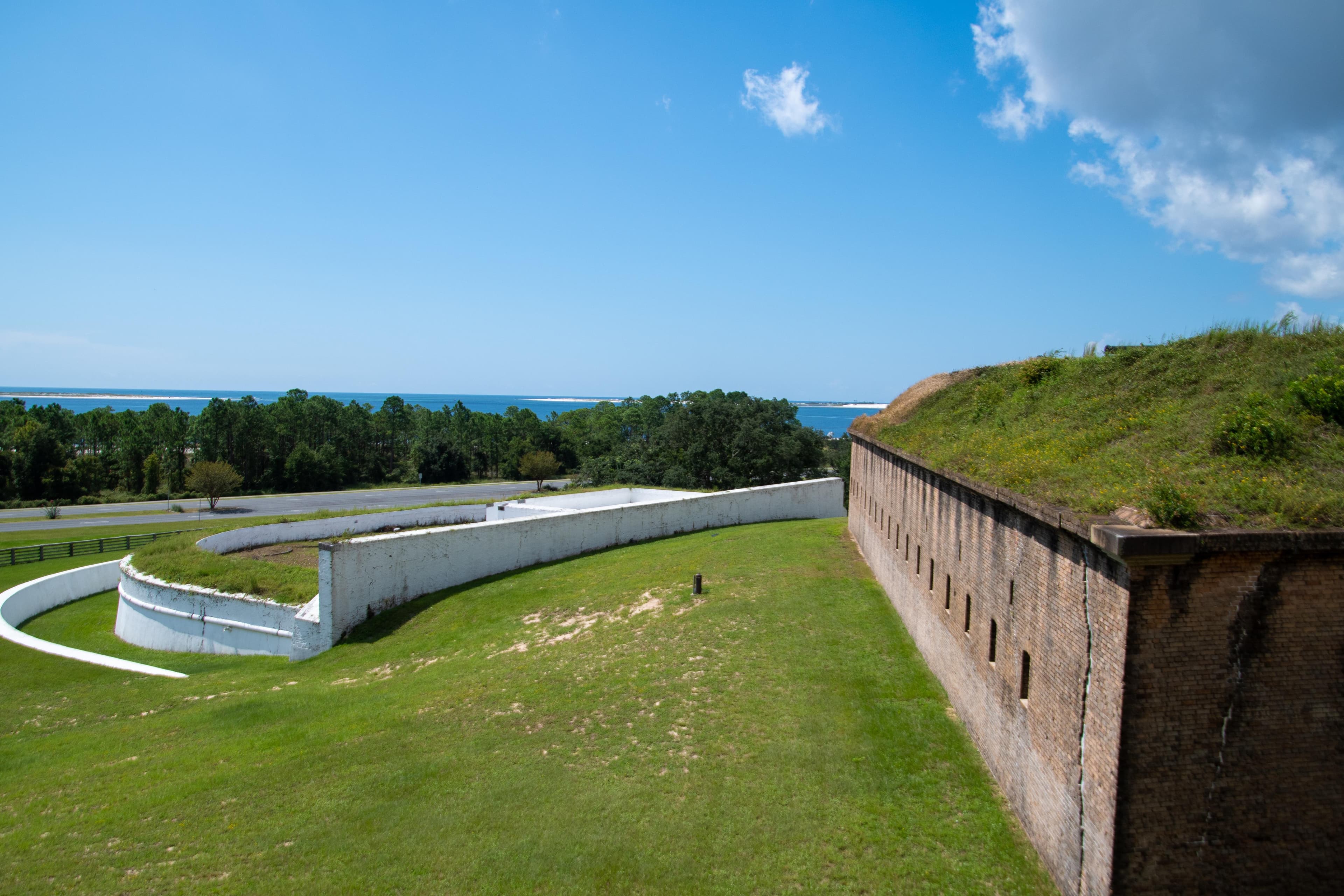
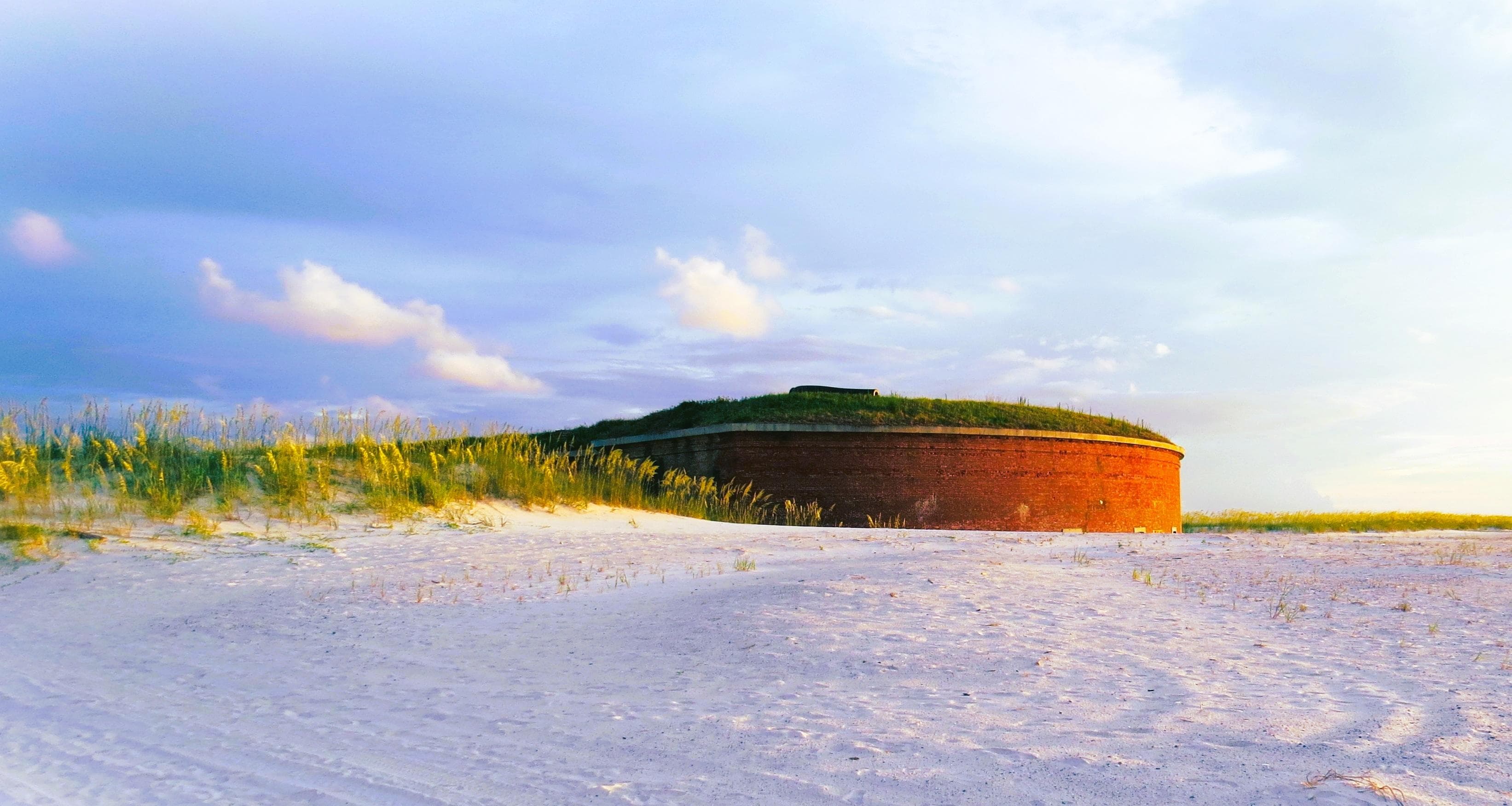
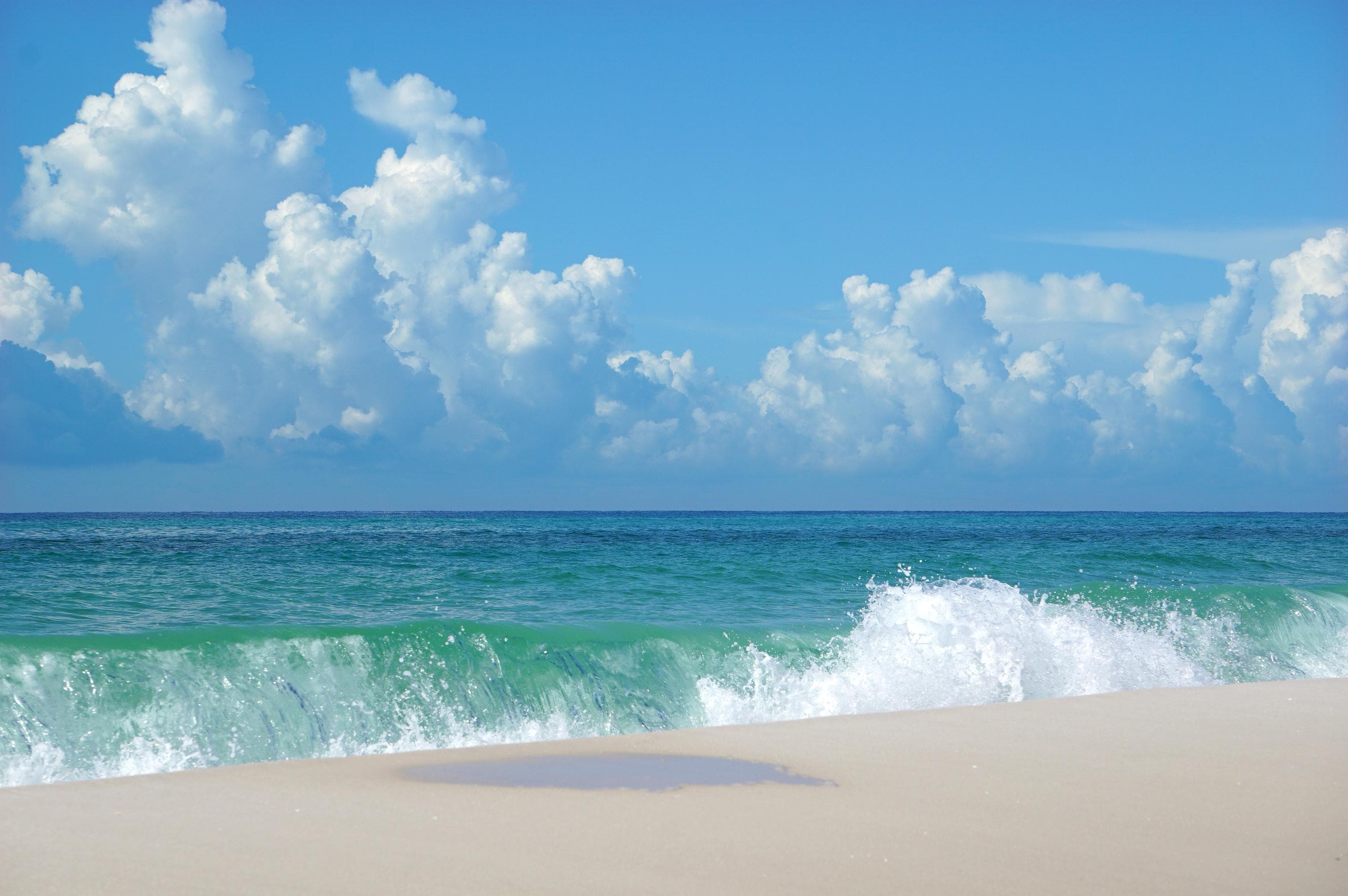
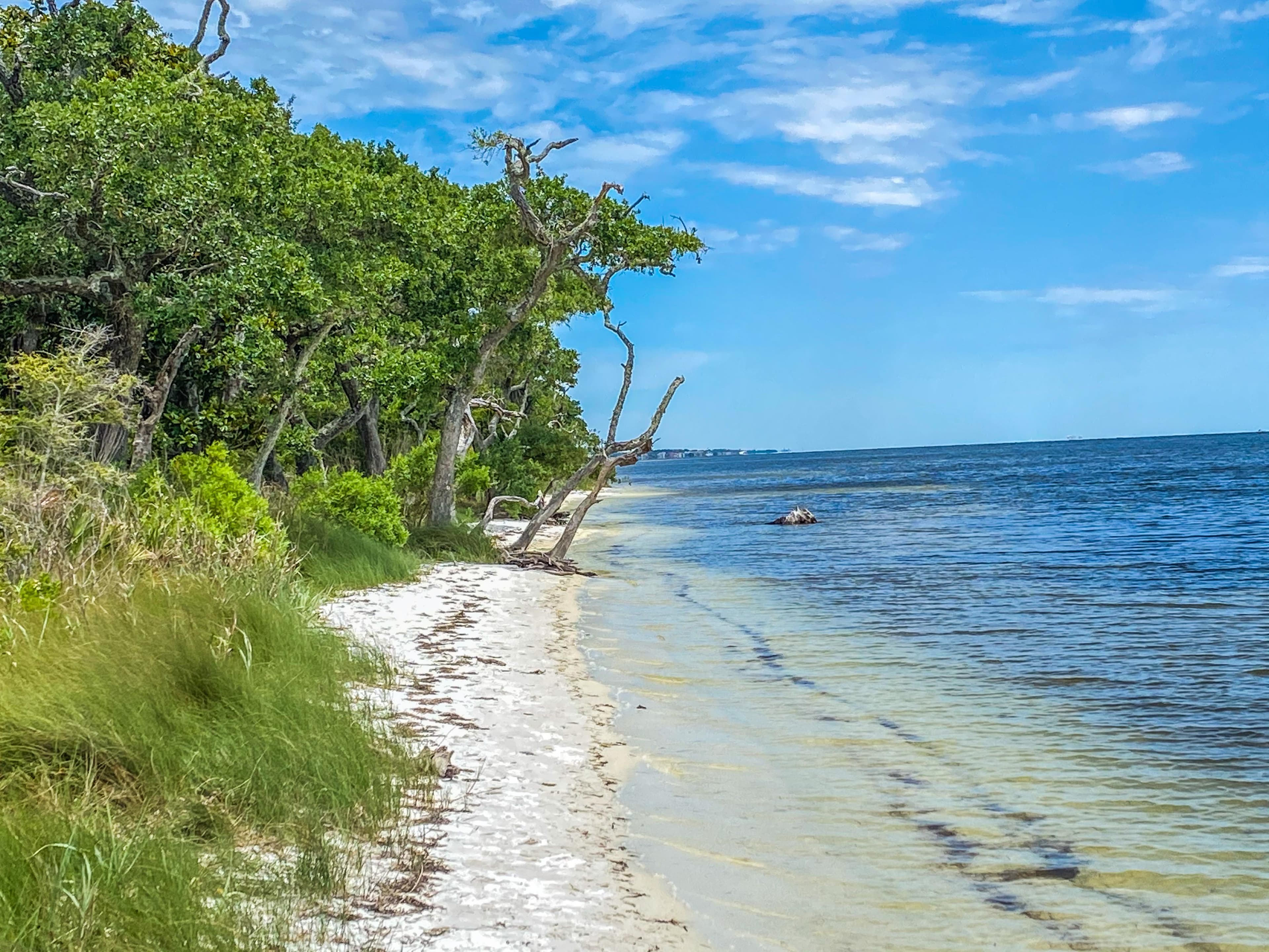
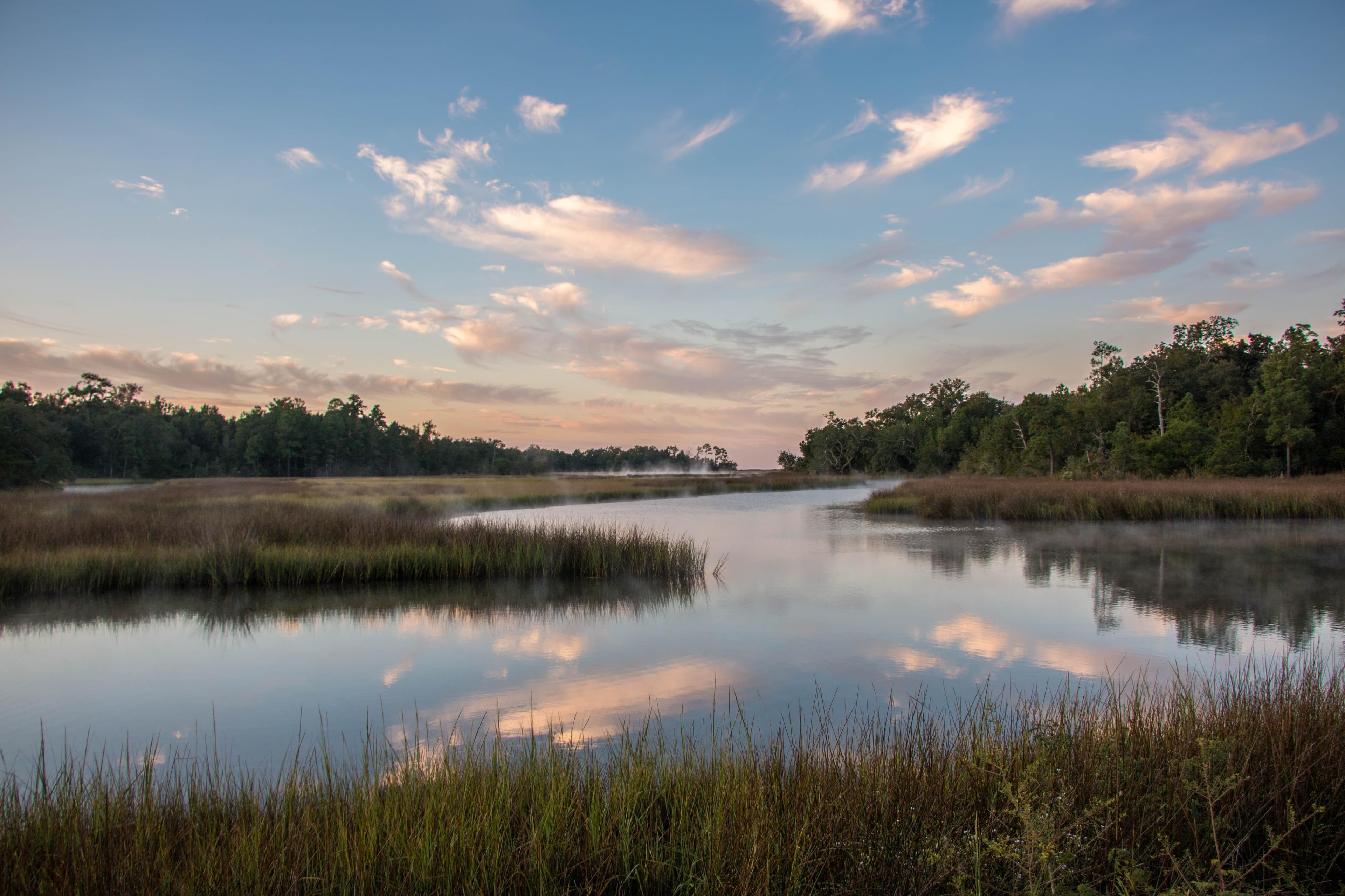
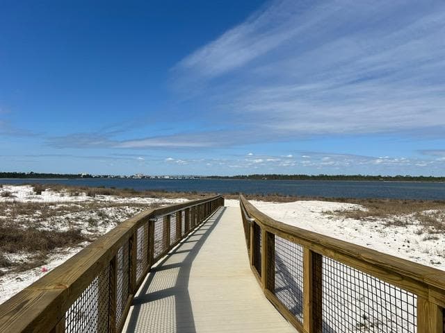
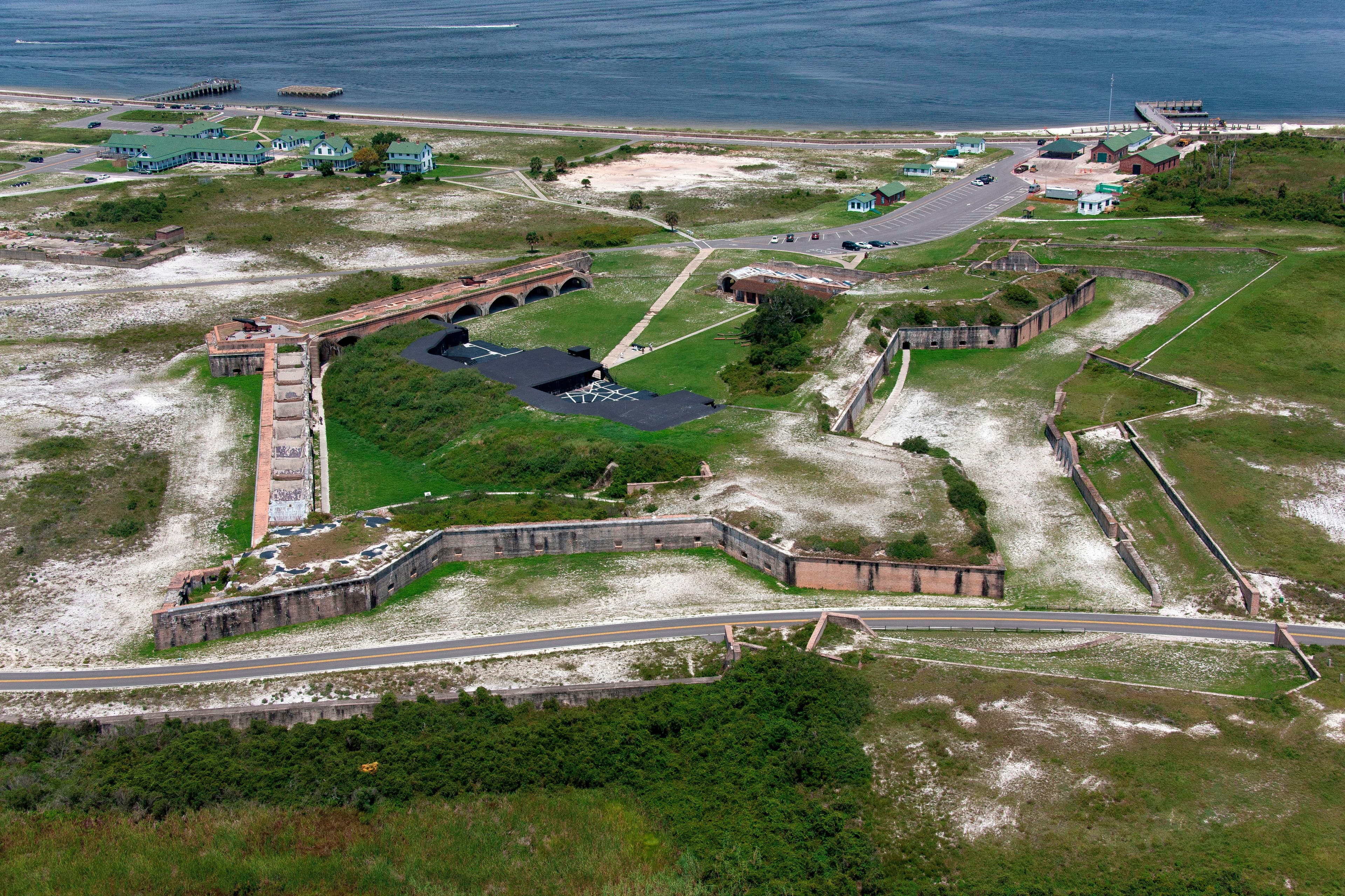
Stay near this park
No horse-friendly stays listed near Gulf Islands National Seashore yet. Know a great barn or property? Help fellow riders by listing it.
List your propertyDirections
Gulf Islands National Seashore is a place of myriad riches - blue-green, sparkling waters, magnificent white beaches, and fertile coastal marshes. Its 13 areas include historic forts, shaded picnic areas, trails, and campgrounds. From Cat Island, Mississippi, it stretches eastward 160 miles tot he Okaloosa Area east of For Walton Beach, Florida.
Source: nps.gov