
Information
Park Store To Go Cashless
Starting August 14th, 2025 the park store will go cashless. All major credit cards, debit cards and mobile electronic payments will be accepted.
Information
Williams Ranch Road Closed
The Williams Ranch Road is currently impassable and closed to public access due to unsafe conditions.
More infoCaution
Devil's Hall is a Strenuous Hike
The hike to Devil's Hall is rated as strenuous. The portion of the route in the wash requires rock scrambling and is dangerous when wet or if water is present. The wash surface is loose gravel and rocks and may be unstable.
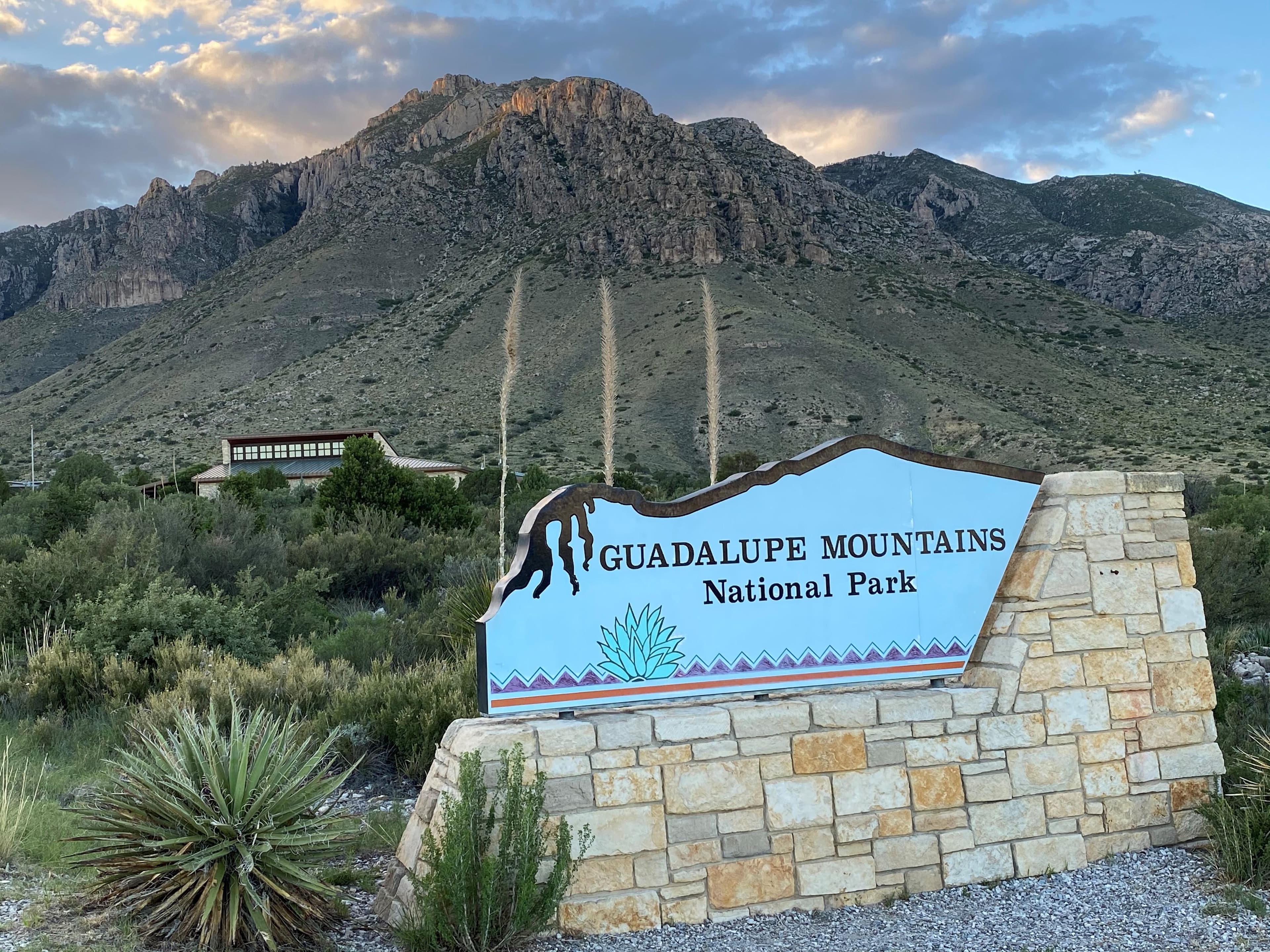
More infoGuadalupe Mountains National Park
TX · Salt Flat
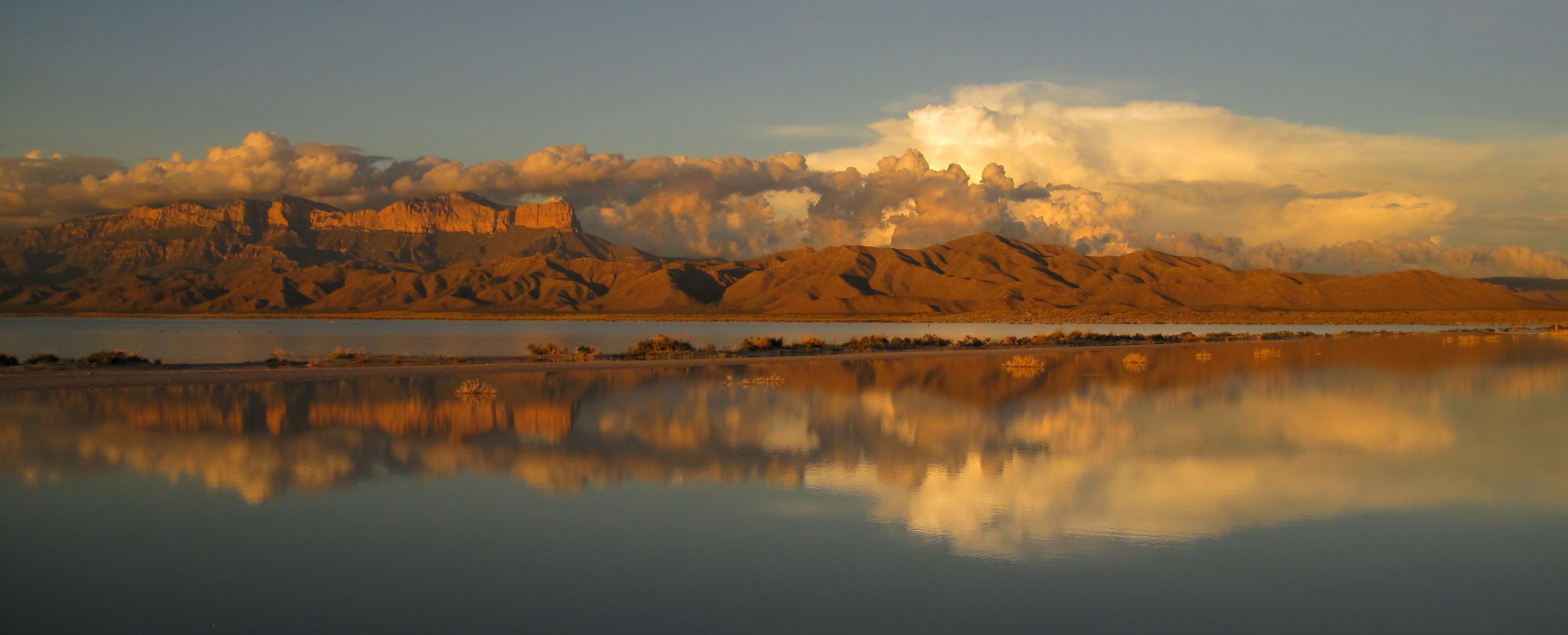
Come experience mountains and canyons, desert and dunes, night skies and spectacular vistas within a place unlike any other. Guadalupe Mountains National Park protects the world's most extensive Permian fossil reef, the four highest peaks in Texas, an environmentally diverse collection of flora and fauna, and the stories of lives shaped through conflict, cooperation and survival.
Riding guide
Highlights
Guadalupe Mountains National Park is rugged, remote, and strikingly beautiful where the Chihuahuan Desert rises sharply into dramatic…
Riding
Rideable terrain here is noted as 35-45 miles, giving riders a clearer sense of scale before they ever unload. Stock use is permitted on designated trails, offering access to backcountry terrain that feels expansive and uncrowded. Conditions can be dry, exposed, and physically demanding, making preparation essential. For riders seeking solitude, big skies, and a distinctly Southwestern landscape, Guadalupe Mountains delivers a powerful and untamed experience.
Rideable terrain
35-45 miles
Trailer parking
Dog Canyon Trailhead (North Side of the Park) This is widely considered the best staging area for equestrians. Why riders prefer it • Large open parking area that can accommodate truck and horse trailer rigs • Direct access to Dog Canyon Trail and Tejas Trail segments • Much quieter and less crowded than the main visitor area • Easier trailer maneuvering compared to other trailheads Dog Canyon provides access to some of the park’s most stock-friendly terrain. Pine Springs Trailhead (Main Visitor Area) This is the main park entrance area, and trailers can sometimes stage here. Features • Large visitor parking lot • Access to several backcountry routes Limitations • Not designed specifically for horse trailers • Can be busy with hikers and park visitors • Turning space may be tight depending on your rig Important Things Riders Should Know • There are no developed horse camps inside the park. • Backcountry permits are required for overnight trips with stock. • Many trails in the park are steep and rocky, limiting trailer-friendly access points. • Summer heat can be extreme, so early morning staging is common.
Horse regulations
Designated Trails Only Horses, mules, and other stock animals are permitted only on designated trails and routes within the park. Cross-country travel or riding off trail is not allowed. This helps protect fragile desert soils and sensitive plant communities. Wilderness / Backcountry Access Overnight stock trips in backcountry zones require a wilderness/backcountry permit. Permits are issued at the visitor center or online where available. Wilderness use is managed with quotas in place to reduce impact. Day riding with stock does not require an overnight permit but riders should check with the backcountry office for current trail status, closures, or restrictions. Grazing & Feed • Grazing is prohibited within the park. • Riders must bring their own certified weed-free feed. • Hay, straw, or forage must not be left on the ground. Pack out unused feed and manure. Water & Desert Conditions Natural springs and water sources can be limited or seasonal. Riders should plan water carefully and confirm reliable sources before departure. Horses may drink at designated water sources but should not linger in streams or springs to protect riparian habitats. Trail Etiquette & Safety • Stay on designated stock trails and travel single-file where required. • Yield appropriately to hikers and pack stock. • Be aware that desert conditions (heat, loose sand, rocky tread) impact stock footing. Party Size & Control Park regulations limit group size for stock use to minimize impact on trails and backcountry sites. Group size guidelines should be confirmed with the backcountry office prior to departure.
Getting here
Use 400 Pine Canyon, Salt Flat, Texas as your primary planning reference before you haul in. Dog Canyon Trailhead (North Side of the Park) This is widely considered the best staging area for equestrians. Why riders prefer it • Large open parking area that can accommodate truck and horse trailer rigs • Direct access to Dog Canyon Trail and Tejas Trail segments • Much quieter and less crowded than the main visitor area • Easier trailer maneuvering compared to other trailheads Dog Canyon provides access to some of the park’s most stock-friendly terrain. Pine Springs Trailhead (Main Visitor Area) This is the main park entrance area, and trailers can sometimes stage here. Features • Large visitor parking lot • Access to several backcountry routes Limitations • Not designed specifically for horse trailers • Can be busy with hikers and park visitors • Turning space may be tight depending on your rig Important Things Riders Should Know • There are no developed horse camps inside the park. • Backcountry permits are required for overnight trips with stock. • Many trails in the park are steep and rocky, limiting trailer-friendly access points. • Summer heat can be extreme, so early morning staging is common.
Planning your visit
Leashed pets are permitted in Guadalupe Mountains National Park only in areas accessed by vehicles, including established roadsides, parking areas, developed picnic areas and campgrounds. Must Know Before You Ride • This is high desert terrain. Heat, wind, and sun exposure can be intense, even outside of peak summer months. Shade is limited on many routes. • Water sources are scarce and often seasonal. Do not rely on springs without confirming current conditions. Plan to carry sufficient water for both rider and horse. • Trails are rocky, steep in places, and physically demanding. Conditioning matters — especially for horses not accustomed to desert mountain footing. • Grazing is not permitted. Bring certified weed-free feed and pack out all unused forage and manure. • Stock use is limited to designated trails. The surrounding desert ecosystem is fragile, and cross-country riding is not allowed. • Backcountry overnight trips require a permit and careful planning. Campsites are minimal and remote. • Services are extremely limited. Cell coverage is unreliable, and the park is far from major towns. Arrive self-sufficient and prepared for emergencies. • Weather can shift quickly, and high winds are common along ridgelines.
Where to stay
Pine Springs Visitor Center is the main visitor-contact point tied to this destination, which is helpful when you want current conditions, maps, and stock-use updates before riding. Horse camping is allowed, so this destination can work as more than a quick in-and-out ride if you want to build a longer federal-land stay around it. For a polished trip plan, pair the ride with lodging, fuel, and resupply planning in or near Salt Flat before heading deeper into federal-land access points.
Entrance fees & passes
- $10.00
Entrance - Per Person
An entrance fee of $10 per person (16 years of age and older) is required; entrance fees/passes permit 1-7 consecutive days of use in this national park. Holders of the Annual, Senior, Military, 4th grade and Access Pass can bring in 3 adults free of charge under their pass. Any pass must be displayed in a vehicle while in the national park.
- $0.00
Entrance - Education/Academic Groups
Entrance fee waivers are available to groups when the purpose of their visit is educational rather than recreational. Completed applications along with required documentation must be submitted via email. Fee waiver requests must be submitted at least six weeks before a scheduled visit to allow for consideration.
- $35.00
Annual Entrance - Park
This pass is valid for entrance into Guadalupe Mountains National Park for one year from the month of purchase. The pass admits up to four adults in a private vehicle and is non-transferable; visitors under 16 years of age are free. You can purchase this pass at the Pine Springs Visitor Center.
Trails
No trails synced for this park yet.
Campgrounds
Blue Ridge Wilderness Campground
5 sites
A Wilderness Use Permit is required for all use of these campsites. Blue Ridge Campground is surrounded by ponderosa pine and Douglas fir; wild roses and grassy areas are nearby - a beautiful location and very remote. The distance from Pine Springs Trailhead: via the Tejas & Blue Ridge Trails is 7.8 miles, via the Tejas, Bush Mountain & Blue Ridge Trails is 8.9 miles.
Reserve a siteBush Mountain Wilderness Campground
5 sites
A Wilderness Use Permit is required for all use of these campsites. A favorite of many for the exceptional vistas and western sunsets. Though the campsites at Bush Mountain are semi-protected from high winds, backpackers will find hiking on the exposed trails to reach the campground difficult during periods of high wind activity. Bush Mountain Campground is 6.2 miles from Pine Springs Trailhead via the Tejas and Bush Mountain Trails. Five designated campsites are defined by tent pads.
Reserve a siteDog Canyon Campground
15 sites · 4 horse-friendly
Dog Canyon is a two-hour drive from the Pine Springs area. The Dog Canyon Campground sits at 6,300 feet in elevation and has 9 tent and 4 RV sites. There is one group site at Dog Canyon that can be reserved for a group of 10-20 individuals. Campground amenities include drinking water and flush toilets (there are NO hookups, dump stations or showers). Only cooking stoves are permitted; charcoal, wood fires, and propane firepits are not permitted.
Reserve a siteFrijole Horse Corral Campground
1 sites · 1 horse-friendly
The Frijole Horse Corral Group Campsite is the only facility for horse users on the east side of the park. The visitor horse corrals and campsites may be reserved up to two months in advance of the visit. This camping area is immediately adjacent Highway 62/180 on the Frijole Ranch access road. Due to proximity to both the highway and the access road, this site has little privacy and is subject to road noise. The Frijole Horse Corral has a capacity of 10 animals.
Reserve a siteGuadalupe Peak Wilderness Campground
5 sites
A Wilderness Use Permit is required for all use of these campsites. This primitive campground is located on the Guadalupe Peak Trail, 3.1 miles from the Pine Springs Trailhead, and 1 mile below the Peak. The elevation gain from the trailhead to the campsites is 2,200 feet. The campground is on a small knoll and only minimally protected from high winds. Five designated campsites are defined by tent pads. These sites are exposed and high winds are common.
Reserve a siteMarcus Wilderness Campground
5 sites
A Wilderness Use Permit is required for all use of these campsites. From Dog Canyon, hikers travel through grassy areas then cross Manzanita Ridge to view West Dog Canyon before descending to an elevation equivalent to the starting point. Not frequently used; pay attention to the trail and rock cairns marking the way. The campground is in pinion and juniper, shaded and protected from the wind. The distance from Dog Canyon is 3.7 miles.
Reserve a siteMcKittrick Ridge Wilderness Campground
8 sites
A Wilderness Use Permit is required for all use of these campsites. Travel through the beautiful McKittrick Canyon before beginning the very steep climb up to the ridge. From McKittrick Canyon Trailhead, the distance is 7.6 miles, with the elevation gain (significant for quite some distance) of over 2,700 feet. If you'd like to visit this beautiful ridge without quite the workout, begin instead at Dog Canyon.
Reserve a siteMescalero Wilderness Campground
8 sites
A Wilderness Use Permit is required for all use of these campsites. This campground is near several trails leading in different directions, making it an excellent choice for a "base camp" while exploring the high country. (Listen for wild turkeys off in the distance.) Mescalero is situated in ponderosa pine and brush, and is on a slope overlooking a small drainage. Located on the Tejas Trail, Mescalero is 6.2 miles from Pine Springs Trailhead or 4.7 miles from Dog Canyon.
Reserve a sitePine Springs Campground
35 sites
The Pine Springs Campground has 20 tent and 13 RV sites available. All campsites are reservable through recreation.gov. Individual campsite cost is $20 per night, per site. There are 2 group sites for groups of 10-20 people. Campground amenities include drinking water and toilets (NO hookups, dump stations or showers). Only cooking stoves are permitted; charcoal, wood fires, and propane firepits are prohibited.
Reserve a sitePine Top Wilderness Campground
8 sites
A Wilderness Use Permit is required for all use of these campsites. Pine Top is the backcountry campground in closest proximity to the Bowl and offers excellent views of the park's highest peaks. Pine Top is an excellent choice for a single night backpack trip. It is 3.9 miles from Pine Springs Trailhead via the Tejas and Bush Mountain Trails. Elevation gain is 2,300 feet. Though secluded in trees, Pine Top is susceptible to high winds & lightning. Eight designated campsites are defined by tent pads.
Reserve a siteShumard Canyon Wilderness Campground
5 sites
A Wilderness Use Permit is required for all use of these campsites. If you enjoy arid Chihuahuan desert or you find yourself fascinated by the geology of the Guadalupes, consider a backpack trip to this remote location. Though it is 9.0 miles from Pine Springs Trailhead, the elevation gain is much less significant than many of the other trails—though it's by no means flat. Do make sure you are prepared for sun, wind, and weather exposure. The trail is not protected by trees along the way.
Reserve a siteTejas Wilderness Campground
5 sites
A Wilderness Use Permit is required for all use of these campsites. The extra distance to the Tejas Wilderness Campground is worth the time for those who wish to stay in a more densely forested surrounding. The tall trees provide deep shade in the morning and late afternoon and protection from high winds aloft. Centrally located, the Tejas Campground is 5.5 miles from Pine Springs Trailhead or 6.2 miles from Dog Canyon.
Reserve a siteWilderness Ridge Wilderness Campground
5 sites
A Wilderness Use Permit is required for all use of these campsites. An interesting hike along the Permian Reef Trail meanders up 2,000 feet to Wilderness Ridge where the sudden transition from rock to trees is refreshing. Once on top, the trail is level through forested and open areas and takes you to the edge of the escarpment where the view is outstanding. Wilderness Ridge Campground is in the trees, and worth the extra distance to save the resource from unnecessary damage.
Reserve a site
Points of interest
"Around The Bend"
POIAs hikers cross "Around The Bend" the landscape changes dramatically and hikers will discover a forest of two-needle pinyon, Douglas fir, ponderosa pine, and a few southwestern white pines.
Bartlett Peak
POIBartlett Peak is the fourth highest point in Texas with an elevation of 8,508 feet above sea level.
Bush Mountain
POIWith an elevation of 8,631 feet , Bush Mountain, is the second highest peak in the state of Texas. Bush Mountain is nearly three miles northwest of Guadalupe Peak and can only be accessed via hiking or horseback.
Campground Junction
POIAt three and one quarter miles up the trail hikers will pass a sign indicating the Guadalupe Peak backcountry campsite. A short trail leads north to the campsite, where there are five individual tent sites. Backpackers wishing to hike the peak for sunrise and sunset can camp here if they obtain a Wilderness Use Permit in advance of their hike.
Carlsbad, New Mexico
POICarlsbad, New Mexico is the closest community within an hour of Guadalupe Mountains National Park. Most services are available here.
Chosa Campground (BLM)
POIThe Chosa Campground is a maintained dry camping area. Camping is free and the camping limit is 14 days. The entire area is a large, square, gravel parking lot which makes it easy for leveling. There are no electric, water, or sewer hookups available. Trash cans are available on site.
Dell City, Texas
POILocated forty-five miles west of the park, Dell City, Texas is a small farming community with limited services, including gas and lodging options.
El Capitan
POIEl Capitan is the eighth highest peak in Texas and it's imposing height and stark outline have made it an iconic image for generations of travelers.
El Capitan Trail Junction
POILess than a quarter mile from the trail is the junction of three trails. Stay straight to continue toward the summit of Guadalupe Peak. A right turn directs hikers toward Devil's Hall and the Guadalupe Peak "stock trail". A left turn here begins the El Capitan Trail.
Frijole Horse Corral Trailhead
POIThe Frijole Horse trailhead is located at the Frijole Horse Campsites and a short distance from the historic ranch.
Frijole Ranch Museum
POIFrijole Ranch is a delightful oasis on the edge of the dry, lower slopes of the Guadalupe escarpment which truly captures the rugged sprit of the American West. Today the Frijole Ranch History Museum occupies the old ranch headquarters, and displays the sequential human history of the Guadalupes from Native Americans and the early ranching community to the establishment of a national park. Imagine what life may have been like in this remote West Texas location 100 years ago.
Frijole Ranch Trailhead
POIThe Frijole Ranch trailhead is located at the end of the Frijole Ranch Road and a short distance from the historic ranch. The popular Smith Springs loop trail begins here. A picnic area is immediately adjacent the trailhead.
Guadalupe Peak
POIGuadalupe Peak is the highest natural point in Texas, with an elevation of 8,751 feet above sea level. The peak can be climbed by a maintained strenuous day hike via the Guadalupe Peak Trail with a 3,000 feet elevation gain at any time of the year.
Hunter Line Shack
POITucked deep into South McKittrick Canyon, the Hunter Line Shack stands as a wilderness remnant of the Hunter-Grisham partnership which consolidated small West Texas ranches into a large corporate entity to make it economically viable in the early Twentieth Century.
Hunter Peak
POIAt 8,368 feet elevation, Hunter Peak is the sixth highest mountain in Texas and only 381 feet lower than Guadalupe Peak.
Lost Peak
POILost Peak is a gentle and easily accessed peak on the north end of Guadalupe Mountains National Park. At 7,830 feet above sea level, Lost Peak is the ninth highest point in the state of Texas.
Manzanita Spring
POIManzanita Spring is a short distance from the Frijole Ranch and a good spot for birding.
McKittrick Canyon Trailhead
POIThe McKittrick Canyon trailhead is the starting point for trails for destinations in McKittrick Canyon as well as above and beyond the canyon. Trail destinations inside the canyon make excellent day hikes. The trailhead is located on the other side of the visitor center from the parking lot. This is a day use area and visitors must exit before the gate closing time each evening.
Park Store at Guadalupe Mountains
POIThe park store is operated by Western National Parks Association, an official non-profit partner of the National Park Service dedicated to supporting the educational mission of Guadalupe Mountains National Park. The park store has a wide range of books, maps, travel guides, and other items available for retail sale
Pine Springs Store & Café
POIThe Pine Springs Café was a roadside business located along U.S Highway 62/180 from the 1930s through the 1990s. Owned by Walter and Bertha Glover, the complex included a gas station, store, café, and guesthouse with cabins for overnight stays.
Pine Springs Trailhead
POIThe Pine Springs trailhead is the starting point for many park trails, and is located near the campground. Except for the Pinery Trail near the visitor center, most of the trails starting here are rated strenuous with significant elevation gains. On busy weekends this trailhead area often fills first.
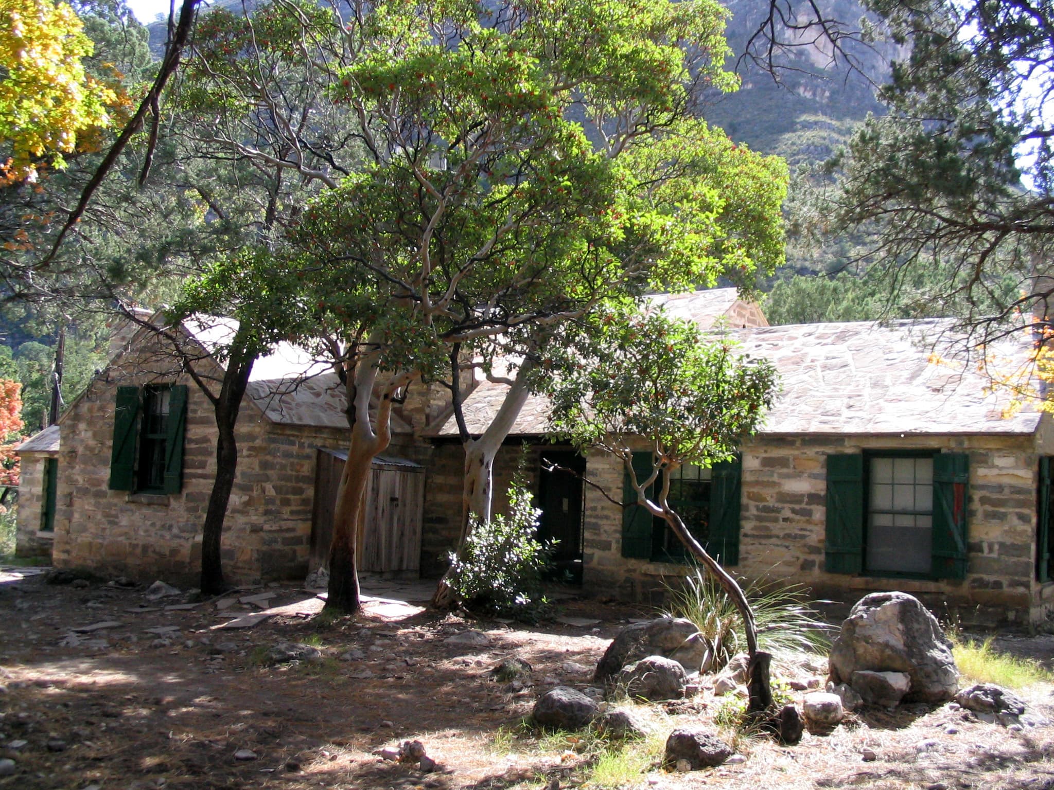
Pratt Cabin
POIPratt Cabin, also referred to as the Stone Cabin, is located in the northeast part of the Guadalupe Mountains National Park which is approximately 110 miles east of El Paso, Texas. Pratt Cabin was designed by noted Houston architect John F. Staub. The Cabin is constructed predominantly of local limestone and pine wood timbers. The design of the Cabin reflects an appreciation of the unique geological resources of the canyon and the rustic setting in which it is situated.
Pure Well
POIOn the remote west side of the Guadalupe Mountains, below Bartlett Peak stands the Pure Well. This abandoned oil well stands as a testament to repeated, unsuccessful efforts to locate oil in the Guadalupe Mountains, even by a family dedicated to preserving this landscape.
Salt Basin Dunes Trailhead
POIThe white gypsum sands of the Salt Basin Dunes rise 100 feet from the desert floor and provide a brilliant contrast to the dark, towering cliffs of the Guadalupe Mountains. This is the only trailhead on the remote western side of the park.
Ship on the Desert
POIDesigned in 1941 and built between 1941 and 1943, the Ship on the Desert was commissioned by Wallace E. Pratt, a petroleum geologist known as an innovator in the field of scientific oil exploration. The Ship on the Desert is an early example of 20th century modernism, distinct for West Texas. Today, Ship on the Desert remains under the care of the National Park Service and is generally not open to the public.
Shumard Peak
POIShumard Peak is the third highest point in Texas with an elevation of 8,615 feet above sea level.
Smith Spring
POIStock Trail Junction
POIThe stock trail junction marks almost a mile up the trail to the Guadalupe Peak summit. The so-called "Stock Trail" is the original trail section and offers a significantly less steep ascent and descent with the trade-off of an additional mile hiked. This junction provides excellent views of Guadalupe Pass, Pine Spring Canyon, the Pine Springs Visitor Center, and Pine Springs Campground.
Sunset Reef Campground (BLM)
POIThe Sunset Reef Campground, located off the Washington Ranch Road, is a reclaimed well pad with 11 developed campsites; five RV spaces and six tent sites. Each site has a covered picnic table and grill for your camping convenience with a vault toilet on site. Visitors can dry camp in the area for a maximum of five nights for free.
Tejas Trail Junction
POIThe junction with the Tejas Trail is a short distance up the trail from the Pine Springs Trailhead. The Tejas Trail is the gateway to the high elevation Wilderness in the park.
The Bridge
POINearly a mile below the summit of Guadalupe Peak, the trail crosses a small chasm by a wooden bridge. This bridge is a well photographed landmark on the trail.
The Dog Canyon Trailhead
POIThe Dog Canyon trailhead is located in the remote northern district of the park. The higher elevation makes for faster access to the wilderness and high country.
The Frijole Ranch Orchard
POIThe orchard at Frijole Ranch was planted around 1906 by J. T. Smith. The Smiths used a variety of techniques to care for the trees, such as irrigation, fertilization with manure, planting alfalfa under the trees, and experimenting with grafting. In 2006, the orchard was partly replanted thanks to the work of a group of Eagle Scouts. The orchard was a vital part of the self-sustaining family farmstead, and the fruit trees continue to be an important part of the landscape.
The Grotto
POIThe open face of a small cave and rock benches and tables await you in the deep shade in McKittrick Canyon, a tempting location for a picnic.
The Hitching Posts
POIThe hitching posts below the summit of Guadalupe Peak mark the end of the portion of the trail that stock are allowed to travel. The trail continues to the left of the hitching posts on slick rock surfaces. You are nearly to the summit!
The Notch
POILocated where the McKittrick Canyon Trail first breaks through the ridge, "The Notch" is a strenuous hike and the last traditional day hike destination within South McKittrick Canyon.
Van Horn, Texas
POILocated 55 miles to the south, the town of Van Horn, Texas is a gateway community to Guadalupe Mountains National Park. The town is located along Interstate 10 and offers a variety of basic services.
Whites City, New Mexico
POIWhites City, New Mexico is a commercial development offering camping and lodging and other services immediately adjacent Carlsbad Caverns National Park and thirty-five miles northeast of Guadalupe Mountains National Park.
Williams Ranch
POIA key remnant of the early Twentieth Century ranching era, the Williams ranch house lies approximately one mile northeast of the original Butterfield Overland Stage Route, which moved further south in 1859. The house is situated in a narrow valley between the Guadalupe Mountains to the east and the Patterson Hills to the west. The ranch sits at the mouth of Bone Canyon, placing it close to the perennial water source of Bone Spring.
Things to do
Backpacking Preparation
A backpacking trip in Guadalupe Mountains Wilderness requires some prior planning and decision-making to ensure the best experience.
Bringing Horses
Camping is authorized for overnight horse users only at the visitor horse corrals, with a permit. The visitor horse corrals and campsites at Frijole Horse Corral Campground and Dog Canyon Campground can be reserved in advance of the visit.
Duration: 2-7 Days
Campground Connector Trail
This short trail connects the visitor center to the campground and the trailhead area at Pine Springs.
Duration: 10-20 Minutes
Can I Take My Dog?
Opportunities for pets are limited. Leashed pets may walk on the short Pine Springs Campground connector trail or along the Pinery Trail from the visitor center to the Butterfield Stage Station.
Duration: 1-1 Hours
Day Hike Preparation
As with most activities, hikers face potential risks. Knowledge and preparation can increase your comfort level and reduce your chances of injury. Remember, you are ultimately responsible for your own safety.
Dealing with Human Waste
Nothing can spoil a trip in the Guadalupe Mountains Wilderness as quickly as the discovery of human waste or toilet paper at a prime camping spot or along the trail. Always use the restroom before hiking. If you are on the trail for the day or an extended trip, be prepared to pack out human waste, toilet paper, diapers, and hygiene products. Human waste disposal bags are highly recommended to transport solid waste.
Duration: 5-15 Minutes
Devil's Hall
The strenuous route to Devil's Hall departs from the Pine Springs Trailhead and is 4.2 miles round-trip. After the first mile the trail enters a rocky wash which leads hikers to an impressive natural rock staircase that connects to a "hallway" formed by steep canyon walls. Rock surfaces in the wash can be slippery when dry and visitors should exercise caution on this hike.
Duration: 3-5 Hours
Drive to Dog Canyon
Dog Canyon, the park's remote north district, is only seven miles as the crow files, but a full two hour drive [one-way] from Pine Springs through a panoramic Chihuahuan Desert and mountain landscape.
Duration: 4-8 Hours
Drive to the Five Points Vista
Located line of sight to Dog Canyon, the Five Points Vista is a scenic overlook near the end of the Guadalupe Rim Road in the Lincoln National Forest's Guadalupe Ranger District. This viewpoint offers spectacular views of the 'Rim' and the Guadalupe Mountains.
Duration: 1-4 Hours
Drive to the Salt Basin Dunes
The white gypsum sands of the Salt Basin Dunes rise 100 feet from the desert floor and provide a brilliant contrast to the dark, towering cliffs of the Guadalupe Mountains. This is a lesser used area of the park; a drive to the dunes provides excellent views of El Capitan and the western escarpment of the Guadalupe Mountains.
Duration: 2-4 Hours
Drive to Williams Ranch
If you have a high-clearance, four wheel drive vehicle, the primitive dirt road to Williams Ranch provides a unique opportunity to get off the beaten path and get close to the remote and imposing western escarpment of the Guadalupe Mountains. The Williams Ranch Road is currently CLOSED.
Duration: 4-6 Hours
El Capitan Viewpoint
On the climb up Guadalupe Pass on U.S. Highway 62/180 just a few miles west of the Pine Springs area, this roadside pull-off provides an unparalleled view to the summit of El Capitan.
Duration: 1-30 Minutes
Foothills Loop
This moderate loop route uses the Frijole Trail and the Foothills Trail to make a loop below the eastern escarpment of the Guadalupe Mountains.
Duration: 2-4 Hours
Guadalupe Peak
Climb to the "Top of Texas" with a hike up Guadalupe Peak. Guadalupe Peak is a rewarding, although very strenuous, 8.4 mile round trip hike with a 3,000 foot elevation gain. It will take from six to eight hours to complete the hike. The peak provides fantastic views from the highest point in the state of Texas (8,751 feet / 2,667 meters). It also introduces hikers to several of the park’s ecosystems including the high desert and the high elevation forests.
Duration: 6-8 Hours
Guadalupe Peak Viewpoint
This viewpoint, located just to the southeast of the park boundary alongside U.S. Highway 62/180 provides an excellent view to the summit of Guadalupe Peak.
Duration: 1-30 Minutes
Highway 54 To The Guadalupes
From the south, Texas State Highway 54 leads directly to the Guadalupes from Van Horn, Texas. Running between the Delaware Mountains to the east and Sierra Diablo on the west, the highway provides a dramatic approach to the Guadalupe Mountains, and on a clear day, you can see the mountains ahead of you for forty miles.
Duration: 1-2 Hours
Highway 62/180 to the Guadalupes
Every visitor to Guadalupe Mountains National Park travels U.S Highway 62/180. Connecting El Paso, Texas to Carlsbad, New Mexico, the highway provides breath-taking views of the park from the north, south, and west. The highway enters the park for five miles and a series of access roads provide access to park features.
Duration: 1-4 Hours
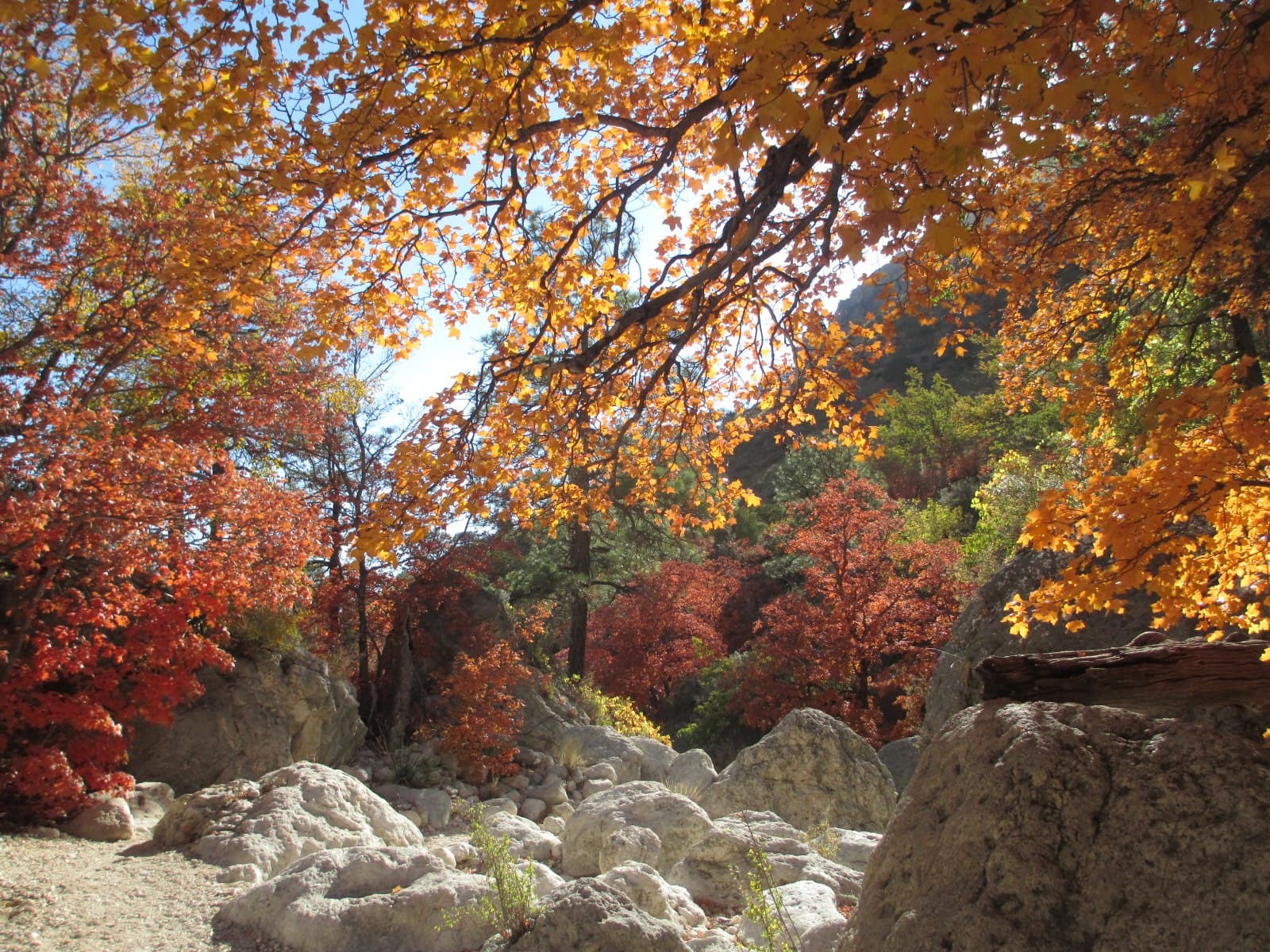
Hike to Fall Colors
Bright fall colors of deciduous trees are not common in the southwest, but elevation and environment combine in the Guadalupe Mountains for a seasonally striking display usually from mid-October to Mid-November. A series of short and long hikes of varying degrees of difficulty will bring you to glimpse of this annual splendor.
Duration: 2-6 Hours
Hiking off-trail
A new kind of experience in the Guadalupe Mountains starts where the maintained trail ends. However, off-trail hiking requires planning and preparation and carries a great deal of risk. Any person or persons planning to hike off trail in the park must stop by the Pine Springs Visitor Center and be issued an off-trail hiking permit.
Duration: 1-8 Hours
Hiking with a Group
In order to protect sensitive ecosystems and limit the impacts on the natural landscape, day-use hiking groups may not be larger than twenty persons on any trails in the park. This page provides suggestions on how to split your group up in order to preserve Wilderness character, and limit adverse impacts on park resources.
Duration: 1-10 Hours
Hunter Peak
The hike to Hunter Peak is a challenging day hike done as a loop up the Bear Canyon Trail and down the Tejas Trail that provides solitude, stunning views, and opportunities for side trails into the Bowl area.
Duration: 6-8 Hours
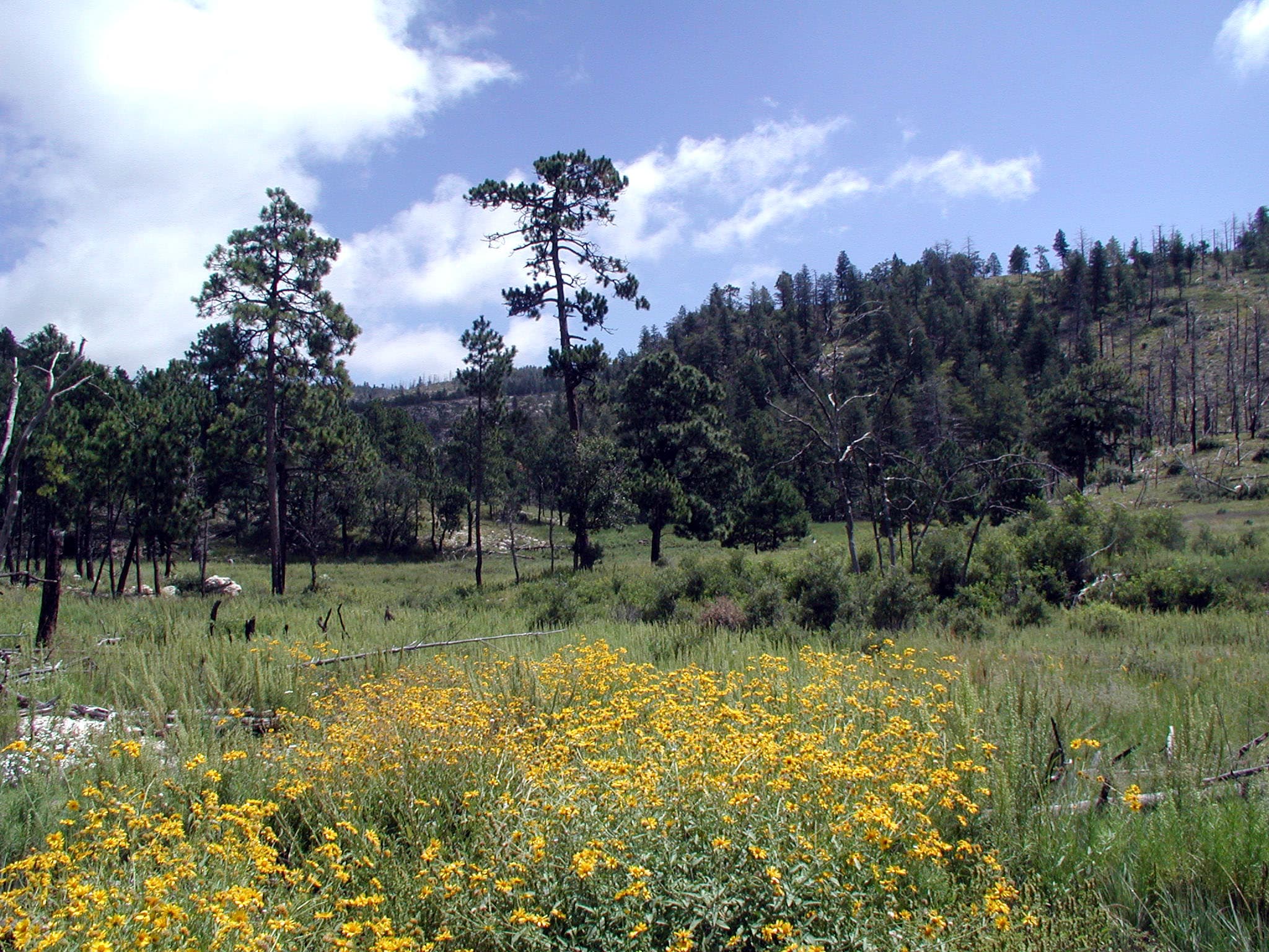
Indian Meadow Nature Trail
The Indian Meadow Nature Trail is an easy 0.6 mile loop that begins across the road from the ranger station and next to the group campsite, offering good views of the landscape. At a leisurely pace it takes 30-45 minutes. The trail is rated easy as it remains almost level after crossing an arroyo.
Duration: 30-45 Minutes
Know the Rules
There are a variety of rules and regulations that dictate how the parks must be managed. These laws and regulations help us protect park resources while also providing visitors with a safe and enjoyable experience.
Leave No Trace
Each of us plays a vital role in protecting our national parks. As we spend time outdoors, in the natural world and in wilderness, it’s important to be conscious of the effects our actions may have on plants, animals, other people, and even entire ecosystems. Following the Leave No Trace Seven Principles, summarized below, can help us minimize those impacts.
Lost Peak Saddle
Hiking the Tejas Trail from Dog Canyon out to the Lost Peak Saddle and back makes an excellent day hike in the Guadalupe Mountains.
Duration: 3-6 Hours
Manzanita Spring
The Manzanita Spring Trail is a 0.5 mile (0.8 km) out and back trail that begins adjacent the Frijole Ranch. Manzanita Spring is a wide pool that provides excellent bird watching opportunities.
Duration: 20-30 Minutes
Marcus Overlook
Hiking the Bush Mountain Trail from Dog Canyon out to the Marcus Overlook and back makes an excellent and usually solitary day hike in the Guadalupe Mountains. From the Marcus Overlook, there are commanding views south into the Guadalupe Mountains and westward.
Duration: 3-5 Hours
McKittrick Canyon Nature Trail
This fascinating, short trail passes an intermittent seep that lies hidden in junipers, then wanders up a southwest slope along an arroyo. Here, plants and animals tolerate true desert conditions. At the top of the trail you can look down at the mouth of McKittrick Canyon and read about Permian Reef geology.
Duration: 30-60 Minutes
McKittrick Canyon to Dog Canyon
The McKittrick Canyon Trail follows the floor of South McKittrick Canyon for four miles before climbing steeply to gain the ridge on the north side of the canyon. This is an arduous climb provides spectacular views into the canyon and to the ridges that border it. This is an extremely rewarding trail, offering both the variety of McKittrick Canyon and the grandeur of the high ridges that surround it.
Duration: 8-12 Hours
McKittrick Ridge
The journey to the top of McKittrick Ridge is "the toughest hike in Texas." This arduous hike is best enjoyed as an overnight hike allowing for rest, recovery, and fabulous night skies at the McKittrick Ridge Wilderness Campground. An overnight Wilderness Use Permit is required for camping.
Duration: 8-12 Hours
Overnight on McKittrick Ridge
The journey to the top of McKittrick Ridge is "the toughest hike in Texas." This arduous hike is best enjoyed as an overnight hike allowing for rest, recovery, and fabulous night skies at the McKittrick Ridge Wilderness Campground. An overnight Wilderness Use Permit is required for camping.
Duration: 2-3 Days
Overnight on Wilderness Ridge
The lesser used Permian Reef Trail leads to sheltered campsites and spectacular views into McKittrick Canyon, making a great destination of a one night, two day backpacking trip into the Wilderness.
Duration: 2-3 Days
Permian Reef Trail
The Permian Reef Trail climbs the north side of McKittrick Canyon to the top of Wilderness Ridge, providing sweeping views into South McKittrick Canyon. Among the least used trails in the park, this long climb is rewarded with solitude and dramatic landscape views.
Duration: 5-7 Hours
Pinery Trail
The Pinery Trail offers visitors an opportunity to take a quick walk on a paved trail. The trail also features ruins of the Old Butterfield Stagecoach Route Pinery Station built in 1858.
Duration: 20-30 Minutes
Pine Springs to McKittrick Canyon
The Tejas Trail is the primary north/south through trail within the park, connecting the Pine Springs Trailhead with the Dog Canyon Trailhead at the park's northern boundary. The central portion of the trail from Pine Top until the McKittrick Canyon Trail junction is forested, passing through the Bowl and numerous drainages. As the trail descends from McKittrick Ridge, visitors are provided with a panoramic experience of the canyon.
Duration: 12-16 Hours
Pratt Cabin
Enjoy the shortest distance into the heart of the canyon by hiking to Pratt Cabin and return (a distance of 4.8 miles). Along this walk you will cross the stream once before arriving at the historic structure. Enjoy a snack or lunch at the picnic tables near or at Pratt Cabin, or sit for a spell on the porch. Volunteers staff Pratt Cabin on occasion; take a look inside the stone structure.
Duration: 2-4 Hours
Salt Basin Dunes Trail
The white gypsum sands of the Salt Basin Dunes rise 100 feet from the desert floor and provide a brilliant contrast to the dark, towering cliffs of the Guadalupe Mountains. From the trailhead, follow the trail to the gypsum sand dune field with excellent views of the western escarpment of the Guadalupe Mountains. There is no shade along the trail, so carry plenty of water and avoid hiking in the midday heat.
Duration: 1-3 Hours
Search and Rescue Policy
Search and rescue actions are conducted on a discretionary basis. The level and necessity of the response is determined through evaluation of the situation by field personnel. Rescuer safety is always our first priority. This park expects visitors to exhibit a high degree of self-reliance and responsibility for their own safety in line with the difficulty of their chosen activities. There is little to no cell reception in most areas of the park.
Shop at the Park Store
The park store is operated by Western National Parks Association, an official non-profit partner of the National Park Service dedicated to supporting the educational mission of Guadalupe Mountains National Park. The park store has a wide range of books, maps, travel guides, and other items available for retail sale. These products complement the interpretive themes you experience when visiting the park. The park store is located in the Pine Springs Visitor Center.
Duration: 10-45 Minutes
Smith Spring Trail Loop
Begin this hike at the trailhead sign. Look for birds, mule deer, and elk as you walk this loop trail to the shady oasis of Smith Spring. Take a break here and enjoy the gurgling sounds of the tiny waterfall before continuing around to sunny Manzanita Spring. Scars from wildland fires of 1990 and 1993 are evident along the trail. The trail is rated moderate, with a round-trip distance of 2.3 miles. Allow one to two hours.
Duration: 1-2 Hours
Tejas Thru Hike
The Tejas Trail is the primary north/south through trail within the park, connecting the Pine Springs Trailhead with the Dog Canyon Trailhead at the park's northern boundary. This major artery can be used to connect to numerous other trails to make a variety of loops. The central portion of the trail from Pine Top until the McKittrick Canyon Trail junction is forested, passing through the Bowl and numerous drainages.
Duration: 7-9 Hours
The Grotto and Hunter Line Shack
Stretch out your day hike into McKittrick Canyon by hiking to the Grotto. Elevation gain doubles as you travel further up canyon, but is still mild at less then 600 feet gained from the trailhead. Exposed cave features and stone picnic tables near the Hunter Line Shack make for a fabulous lunch destination.
Duration: 3-5 Hours
The Notch
The hike to "the Notch" is a challenging day hike that proceeds through McKittrick Canyon to a dramatic viewpoint about half way up toward McKittrick Ridge.
Duration: 5-7 Hours
Trail Rides
For those bringing horses and other stock to the Guadalupe Mountains, the park offers diverse riding opportunities. Sixty percent of the trails are open to stock use.
Duration: 4-10 Hours
Virtual Summit Log
When you reach a summit or other destination in the park, take a group photo or selfie in areas of the park and post to social media and include the hashtag #GuadalupeMountains #guadalupepeak #hunterpeak #lostpeak or others hashtags using your device and social media service.
Visit the historic Frijole Ranch
Frijole Ranch is a delightful oasis on the edge of the dry, lower slopes of the Guadalupe escarpment which truly captures the rugged sprit of the American West. Today the Frijole Ranch History Museum occupies the old ranch headquarters and displays the human history of the Guadalupes. The grounds are open from dusk to dawn, with picnic tables at the parking area and under the large shade trees in the courtyard. Bring your binoculars; this is an excellent location for birding!
Duration: 10-60 Minutes
What Time Is It?
Guadalupe Mountains National Park is in the Mountain Time Zone. Visitors relying on electronic devices may be misled, as cell signal service for the park comes from towers located in the Central Time Zone. We strongly suggest that you set your phone or other device to Mountain time during your visit.
Duration: 1-5 Minutes
Visitor centers
Dog Canyon Ranger Station
Visitors can pick up brochures and maps from the Dog Canyon Ranger Station when staff or volunteers are available. The Dog Canyon Ranger Station is open intermittently depending on staff availability. If staff and volunteers are present they may be patrolling trails or the campground and not necessarily inside the station.
Get directionsMcKittrick Canyon Contact Station
Visit the contact station at the mouth of McKittrick Canyon (staffed during peak seasons in the spring and fall). Pick up a park brochure, and view the outside exhibits and video.
Get directionsPine Springs Visitor Center
Pine Springs Visitor Center is the park's main visitor center and headquarters. Visitors can pay entrance and camping fees, tour the museum, purchase items from the park store, pick up brochures and maps, and obtain overnight wilderness use permits here.
Get directions
Webcams
Dog Canyon View
Currently unavailable.
El Capitan View
Currently unavailable.
McKittrick Canyon View
Currently unavailable.
McKittrick Parking Lot
Currently unavailable.
Pine Springs Canyon View
Currently unavailable.
Hours of operation
Pine Springs
The Pine Springs area, including the campground, visitor center, trailhead, and associated parking areas are open and accessible all of the time during normal operations. Camping is permitted in designated campsites only.
Mon
All Day
Tue
All Day
Wed
All Day
Thu
All Day
Fri
All Day
Sat
All Day
Sun
All Day
Salt Basin Dunes
Located on the remote west side of the park, these striking dunes cover nearly 2,000 acres. The Salt Basin Dunes are designated day use only and are accessible for visitation beginning at sunrise to 30 minutes after sunset. Camping is specifically prohibited. The surface of the access road is clay. During rainy weather, the road becomes dangerously slippery; it is unsafe to travel when wet. The speed limit is 25 miles per hour. Watch for livestock on the roadway.
Mon
Sunrise to Sunset
Tue
Sunrise to Sunset
Wed
Sunrise to Sunset
Thu
Sunrise to Sunset
Fri
Sunrise to Sunset
Sat
Sunrise to Sunset
Sun
Sunrise to Sunset
McKittrick Canyon
McKittrick Canyon is designated as day-use only, with visiting hours from 8:00 a.m. - 5:00 p.m. (Mountain Time) daily. Please exit McKittrick Canyon before the posted closing time. The entrance gate on U.S.Highway 62/180 is locked each evening.
Mon
8:00AM - 5:00PM
Tue
8:00AM - 5:00PM
Wed
8:00AM - 5:00PM
Thu
8:00AM - 5:00PM
Fri
8:00AM - 5:00PM
Sat
8:00AM - 5:00PM
Sun
8:00AM - 5:00PM
Frijole Ranch
The Frijole Ranch Road provides access to the Frijole Horse Campsites, the Frijole Ranch History Museum, and the associated trailhead. A picnic area is located at the end of the road. Camping is permitted in designated campsites only.
Mon
Sunrise to Sunset
Tue
Sunrise to Sunset
Wed
Sunrise to Sunset
Thu
Sunrise to Sunset
Fri
Sunrise to Sunset
Sat
Sunrise to Sunset
Sun
Sunrise to Sunset
Dog Canyon
Dog Canyon lies in a secluded, forested canyon on the north end of the park at an elevation of 6,300 feet. Remote and far removed from civilization; it stands at the edge of the wilderness boundary, and offers an ideal location for quiet camping, birding, hiking, and solitude. A visitor center, trailhead, and campground are available. The Dog Canyon district is open all day during normal park operations.
Mon
All Day
Tue
All Day
Wed
All Day
Thu
All Day
Fri
All Day
Sat
All Day
Sun
All Day
Activities
Weather
The Guadalupe Mountains are known for high winds year-round; gusts can reach 60MPH or higher. In winter the mountains experiences occasional, light snowfalls which seldom last more than a day. From May through October, temperatures vary with highs between 80F-100F+ with lows in the 40F-60F range. November to April is generally milder with highs in between 50F-70F with lows in the 30F-50F range. Elevations above 8,000’ will be about 10F cooler than headquarters, with corresponding wind-chill.
Contact
Photos
Stay near this park
No horse-friendly stays listed near Guadalupe Mountains National Park yet. Know a great barn or property? Help fellow riders by listing it.
List your propertyDirections
Guadalupe Mountains National Park is located on the north side of US Hwy 62/180. If you are traveling east from El Paso, TX, we are 110 miles East of the city. Follow US Hwy 62/180 North to the Pine Springs Visitor Center. If you are traveling from Van Horn, TX, you will travel north on US 54 and make a right-hand turn at the junction of US 62/180 to arrive at the park. If you are traveling west from Carlsbad, NM, you will travel on US Hwy 62/180 South and cross into Texas. Follow signs to the park.
Source: nps.gov