
Juan Bautista de Anza National Historic Trail
AZ · CA · Martinez
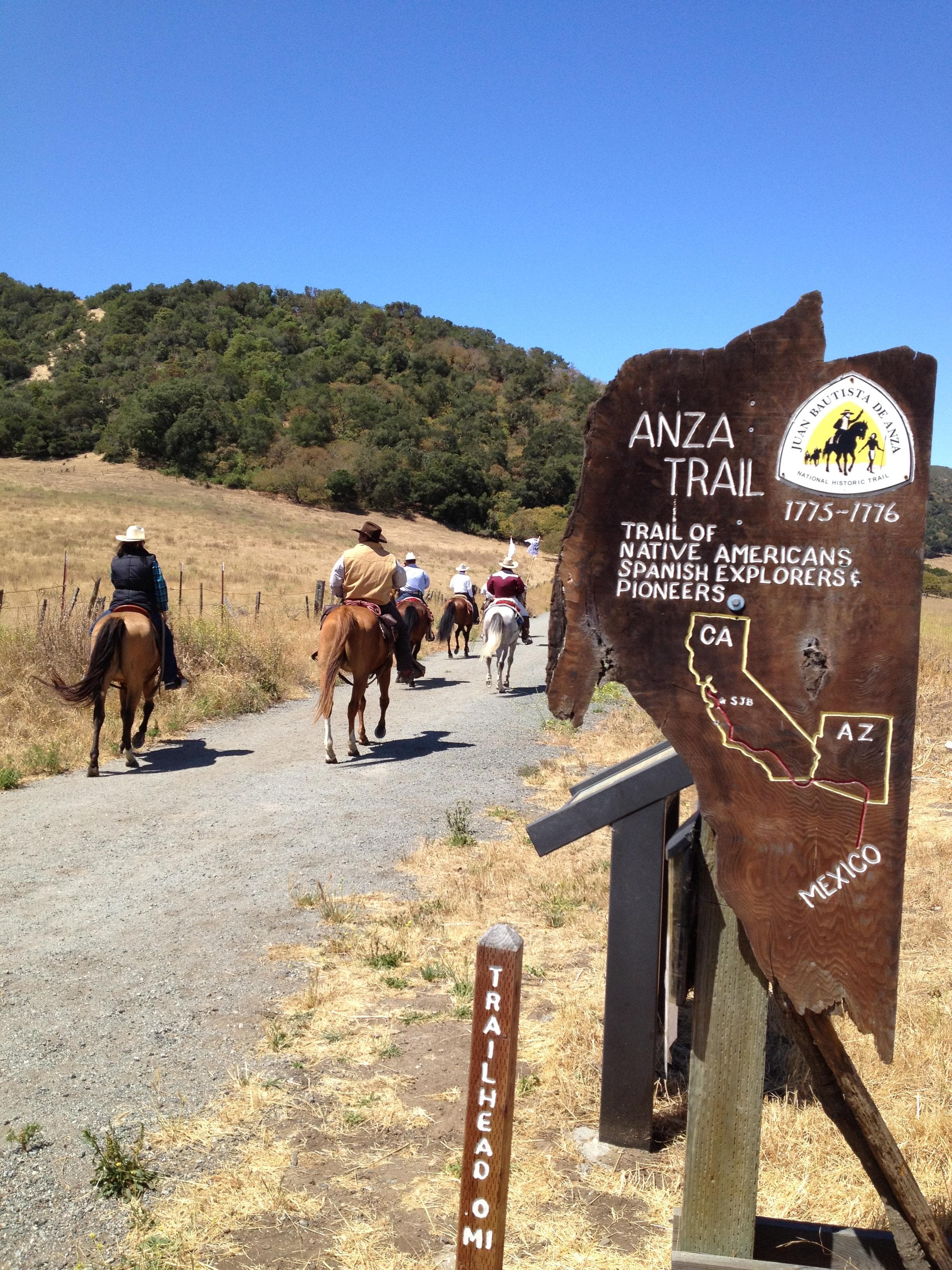
The Juan Bautista de Anza National Historic Trail covers over 1200 miles through the homelands of 70+ Tribal communities. It follows the historic route of the 1775-76 Spanish colonizing expedition from Sonora, Mexico to San Francisco, CA. Whether urban or rural, the trail offers adventure, diverse cultural perspectives, and an opportunity to experience history.
Riding guide
Highlights
The Juan Bautista de Anza National Historic Trail traces the historic route taken in 1775–1776 by Spanish explorer…
Riding
Rideable terrain here is noted as Up to 1,210 miles, giving riders a clearer sense of scale before they ever unload. For equestrians, the Anza Trail offers a unique experience compared with most national park units. Rather than a single park with a continuous trail system, the route functions as a 1,200-mile historic corridor connecting dozens of public lands, regional parks, and natural areas across Arizona and California.
Rideable terrain
1,210 miles
Trailer parking
Tumacácori / Santa Cruz River Trailheads (Arizona) Location: Near Tumacácori National Historical Park along the Santa Cruz River corridor. Why riders use it One of the longest continuous Anza Trail riding segments in Arizona Multi-use trail following the Santa Cruz River corridor Several trailheads and dirt parking areas suitable for horse trailers Scenic desert riparian riding with cottonwoods and open desert views. Marana / Santa Cruz River Park Trailheads (Arizona) Location: Near Marana northwest of Tucson. Why riders use it Long developed section of the Anza Trail through Santa Cruz River Park Large public trailheads and park parking areas that accommodate trailers Wide multi-use path ideal for relaxed desert riding. Sonoran Desert National Monument Access (Arizona) Location: Access roads off Arizona Highway 238 near Sonoran Desert National Monument. Why riders use it Remote desert riding along a 12-mile Anza recreation trail segment Dirt access roads with staging areas suitable for trailers Expansive Sonoran Desert terrain with saguaros and mountain views. Martha McLean – Anza Narrows Park (Southern California) Location: 5759 Jurupa Ave, Riverside, California. Why riders use it Riverside park directly on the Santa Ana River section of the Anza Trail Known local equestrian access point Trail connections along the river corridor and regional trail system. Cortez Avenue / Jim Green Trailhead (Central California) Location: Near San Juan Bautista. Why riders use it Dedicated equestrian parking on Cortez Avenue Access to rural Anza Trail segments crossing farmland and hills Staging area commonly used by riders exploring the Central Coast section. Bay Area Regional Parks (Northern California) Location: East Bay regional parklands near Richmond and surrounding parks. Why riders use it The trail passes through several regional parks with equestrian staging areas Extensive multi-use trail networks that connect to the Anza corridor Some of the longest developed riding segments along the historic route.
Horse regulations
Horseback riding along the Juan Bautista de Anza National Historic Trail is permitted on many developed segments of the trail corridor. However, because the trail crosses numerous jurisdictions, regulations vary depending on the specific land manager responsible for each segment. Several core guidelines generally apply for equestrians using the trail. Riding Is Allowed Only Where Permitted Not all portions of the historic corridor are open to horses. Equestrian use is limited to multi-use trail segments and public lands where horseback riding is permitted by the managing agency. Some sections of the trail follow paved pathways or urban greenways that may prohibit horses. Local Land Manager Regulations Apply The trail passes through lands managed by: Federal agencies State parks Regional park districts City trail systems Each segment may have its own rules governing equestrian use, trail access, and parking. Stock Control and Trail Courtesy Riders are generally expected to: Maintain control of horses at all times Yield appropriately to hikers and cyclists Ride single file where trails are narrow Avoid damaging vegetation or leaving established routes. Feed and Invasive Species Prevention Many land managers along the trail encourage or require: certified weed-free hay or feed clean trailers, tack, and hooves before entering trail systems. Organized Events and Commercial Use Commercial tours or organized large group rides may require special use permits from the managing agency of the specific trail segment.
Getting here
Use 4202 Alhambra Ave, Martinez, California as your primary planning reference before you haul in. Tumacácori / Santa Cruz River Trailheads (Arizona) Location: Near Tumacácori National Historical Park along the Santa Cruz River corridor. Why riders use it One of the longest continuous Anza Trail riding segments in Arizona Multi-use trail following the Santa Cruz River corridor Several trailheads and dirt parking areas suitable for horse trailers Scenic desert riparian riding with cottonwoods and open desert views. Marana / Santa Cruz River Park Trailheads (Arizona) Location: Near Marana northwest of Tucson. Why riders use it Long developed section of the Anza Trail through Santa Cruz River Park Large public trailheads and park parking areas that accommodate trailers Wide multi-use path ideal for relaxed desert riding. Sonoran Desert National Monument Access (Arizona) Location: Access roads off Arizona Highway 238 near Sonoran Desert National Monument. Why riders use it Remote desert riding along a 12-mile Anza recreation trail segment Dirt access roads with staging areas suitable for trailers Expansive Sonoran Desert terrain with saguaros and mountain views. Martha McLean – Anza Narrows Park (Southern California) Location: 5759 Jurupa Ave, Riverside, California. Why riders use it Riverside park directly on the Santa Ana River section of the Anza Trail Known local equestrian access point Trail connections along the river corridor and regional trail system. Cortez Avenue / Jim Green Trailhead (Central California) Location: Near San Juan Bautista. Why riders use it Dedicated equestrian parking on Cortez Avenue Access to rural Anza Trail segments crossing farmland and hills Staging area commonly used by riders exploring the Central Coast section. Bay Area Regional Parks (Northern California) Location: East Bay regional parklands near Richmond and surrounding parks. Why riders use it The trail passes through several regional parks with equestrian staging areas Extensive multi-use trail networks that connect to the Anza corridor Some of the longest developed riding segments along the historic route.
Planning your visit
Because the Anza Trail spans multiple states and landscapes, equestrian planning requires a bit more preparation than riding in a single park. The Trail Is Not Continuous for Horses Although the historic route stretches more than 1,200 Miles, it is not maintained as one continuous horseback trail. Riders typically experience the trail through individual segments developed by local agencies. Segment Research Is Essential Before traveling, riders should research the specific section they plan to ride, including: Equestrian access rules Trailer parking locations Surface conditions. Terrain Varies Widely Riders may encounter a variety of trail conditions depending on the region, including: Desert sand and washes Gravel and dirt paths River corridor trails Rural ranch roads Paved multi-use pathways in urban areas. Weather Conditions Can Be Extreme Conditions vary dramatically across the trail corridor. Examples include: extreme heat in the Sonoran Desert seasonal flooding in river corridors fog and cooler coastal weather in California. Water Availability Is Limited in Some Areas Desert segments in Arizona and southern California may have very limited water sources for horses and riders. Planning water logistics is essential. Multi-Use Trail Traffic Many developed sections of the Anza Trail are shared with hikers, cyclists, and other trail users, especially near urban areas. Riders should be prepared for encounters with other visitors.
Where to stay
John Muir National Historic Site is the main visitor-contact point tied to this destination, which is helpful when you want current conditions, maps, and stock-use updates before riding. This entry reads best as a bring-your-own-horse destination rather than a horse-rental stop, and amenities should be confirmed directly before travel. For a polished trip plan, pair the ride with lodging, fuel, and resupply planning in or near Martinez before heading deeper into federal-land access points.
Trails
No trails synced for this park yet.
Campgrounds
No campgrounds listed for this park.
Points of interest
Antioch/Oakley Regional Shoreline
POIAnza-Borrego Desert State Park
POIAnza-Borrego Desert State Park is the largest of the California State Parks and protects a crossroads of desert landscapes and ecosystems. It is located on the traditional homelands of the Cocopah and Cuahuilla. The park contains a particularly dramatic and scenic section of the Juan Bautista de Anza National Historic Trail.
Big Break Regional Shoreline
POIChristopher Columbus Park
POIColorado River State Historic Park
POIThe Colorado River State Historic Park preserves and interprets the complex and dynamic history of Yuma and the Colorado River, including the Anza expedition who crossed the Colorado River near here in November of 1775. Anza Trail Passport Stamp #12 is located in the Colorado River State Historic Park Visitor Center.
Don Fernando Pacheco Adobe
POIDon Salvio Pacheco Adobe
POIGila Bend
POIGila Bend Museum and Visitor Center provides exhibits about the history and culture of the area. The Anza Trail Passport Stamp #10 is located here.
Gila River Indian Community
POIHistoric Hacienda de la Canoa
POIHistoric ranch along the Juan Bautista de Anza National Historic Trail. The site is on the National Register of Historic Places and includes historic campsite #15 of the Anza expedition.
Juan de Anza House, CA
POIThe Spanish founded Mission San Juan Bautista as the 15th mission in 1797. One of the oldest buildings in San Juan Bautista’s Third Street Historic District and a National Historic Landmark in its own right is the Juan de Anza House or Casa Juan de Anza Adobe that dates from 1834 during the period of Mexican control.
Las Lagunas de Anza Interpretive Site
POIJuan Bautista de Anza NHT, Passport Stamp #2 - Las Lagunas de Anza, AZ
Mission San Agustín del Tucson
POIMission San Xavier del Bac
POIMission San Xavier del Bac is an important site along the Anza Trail and an iconic image of southern Arizona. It is located on the Tohono O'odham Nation and the mission church is intimately linked to the history of the people who have claimed this land as home for centuries.
Museum of Sonoran History - Museo Costumbrista de Sonora
POIThe Museum of Sonora History in Álamos, Sonora, includes interpretation and information about the Anza Expedition. An Anza NHT Passport Stamp is also found here.
Picacho Peak (Cerro de Tacca)
POIPicacho Peak is a prominent landmark and an integral piece of the cultural landscape in southern Arizona. It is an Arizona State Park and an official NPS Anza NHT Passport Stamp can be found here at the visitor center.
Presidio San Agustín del Tucson
POIThe Presidio San Agustín del Tucson Museum is a re-creation of the Tucson Presidio built in 1775, the same year that the Anza expedition passed through along the Santa Cruz River along the overland route that would establish the city of San Francisco and Spanish power in Alta California. An Anza NHT Passpost Stamp is located here.
Puerto del Azotado
POIRoberto-Suñol Adobe
POISaguaro National Park West
POISanta Cruz River Park
POISanta Cruz Valley National Heritage Area
POISanta Cruz Valley National Heritage Area celebrates the region’s natural resources, rich history, and heritage shaped by generations of Native American, Spanish, and Mexican cultures.
Sonoran Desert National Monument
POITubac Presidio State Historic Park
POITubac Presidio State Historic Park is a Spanish Colonial site in Arizona and a Certified Interpretive Site on the Juan Bautista de Anza National Historic Trail. An Anza NHT Passport Stamp is available at the visitor center. The site also provides trailhead access to a portion of the Anza Recreational Trail.
Tumacácori - Anza Trail Junction
POIThe Santa Cruz River has long been a highway of trade and travel. Prehistoric people followed the river to trade with neighbors. The O’odham farmed along the river, using the floodplain and low banks to grow crops. Later, missionaries and explorers would rely on these existing networks to colonize the area.
Waterbird Regional Preserve
POIYuma Crossing National Heritage Area
POIThe Colorado River crossing at Yuma, Arizona, has a rich history, accented in recent years by irrigation works that have transformed the region into an agricultural oasis. But in the process, riparian areas suffered and the riverfront became blighted. Today, Yuma Crossing National Heritage Area is working to restore the region’s wetlands and reconnect the city to its historic downtown.
Things to do
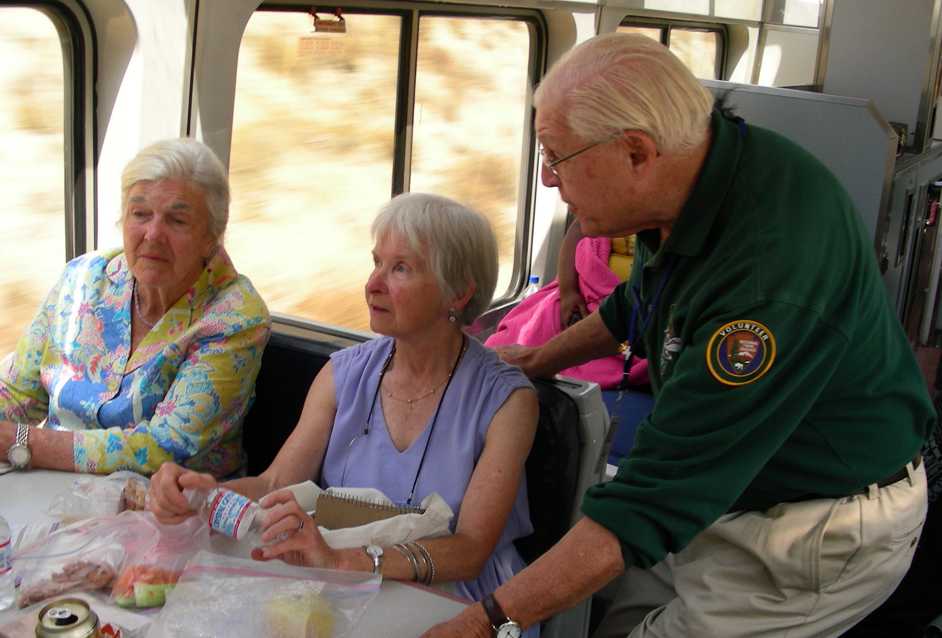
Experience the Anza Trail by Train
Experience the Anza Trail with NPS volunteer historians and interpreters on board Amtrak's Coast Starlight between Santa Barbara and San Jose.
Hike, cycle, or ride through Fort Ord National Monument
Hike or ride a strenuous 4.5-mile segment that crosses the majestic grasslands of Fort Ord National Monument. The Monument segment is anchored by the Creekside Terrace Trailhead and the Badger Hills Trailhead where restrooms, maps, and interpretive displays are provided. The Creekside Terrace Trailhead has potable water.
Duration: 30-150 Minutes
Hike the Anza Trail from Tumacácori to Tubac, AZ
Hike through shady cottonwood galleries and mesquite bosques along this six-mile stretch of the Anza Trail between Tumacácori National Historic Park and Tubac Presidio State Historic Park.
Duration: 2-6 Hours
Hike the Anza Trail through Moreno Valley
Enjoy an easy 8-mile out-and-back urban trail through Moreno Valley. This multi-use paved path starts at a city park and ends at a California state recreation area.
Duration: 2-4 Hours
Hike the Arrowhead Loop Trail
Explore part of the Anza Recreational Retracement Trail by hiking this challenging 4-mile one-way loop through Coyote Valley Open Space Preserve in Santa Clara, CA.
Duration: 2-5 Hours
Hike the Delta de Anza/Mokelumne Loop
Enjoy a moderate 5.62-mile loop by taking the Mokelumne Coast-to-Crest Trail to the Delta de Anza Trail. This paved loop passes through or near several schools and community parks and provides access to Contra Loma Regional Park and Black Diamond Mines Regional Preserve. The trail has several steep inclines and is not recommended for people who use a wheelchair.
Duration: 2-4 Hours
Hike the Santa Cruz River
The Santa Cruz River forms a ribbon of life in the Pimería Alta. Whether walking to its edge or along its length, visitors will encounter the fundamental building blocks of nature and human civilization.
Duration: 30 Minutes
Visitor centers
Anza-Borrego Desert State Park Visitor Center
The Visitor Center is located at the west end of Palm Canyon Dr. Approaching from the west on S-22, make a left at the stop sign at the intersection of Montezuma Valley Rd and Palm Canyon Dr. Follow Palm Canyon Drive to the parking lot at the end. If approaching from the east, Borrego Salton Seaway, follow S-22 through the town of Borrego Springs. S-22 will turn into Palm Canyon Drive. Follow Palm Canyon Drive all the way to the parking lot at the end of the road.
Get directionsBig Break Visitor Center at the Delta
The Visitor Center is accessible from Big Break Road. It includes hands-on and informational displays about the Delta. The center is staffed by Naturalists and Student Aides who are happy to share information about the park and activities in the area, including wetland walks and adjoining trails. In addition, Big Break Regional Shoreline offers picnic and meadow areas, a small, shaded amphitheater, boat and kayak launch facilities, and a fishing pier.
Get directionsGila Bend Visitor Center
An affiliated Arizona Office of Tourism Visitor Center, travelers can expect to find information about any of the four regions of our amazing State, as well as destination information about Gila Bend. Call (928) 683-2255 for more information.
Get directionsGriffith Park Visitor Center
Griffith Park Visitor Center, 4730 Crystal Springs Drive, Los Angeles, CA, 90027. Stop by the Visitor Center for information regarding Griffith Park activities, attractions, and permits. You may also call the Visitor Center Permit Office at (323) 644-2050, Tuesday to Saturday, from 9:00 am until 4:00 pm.
Get directionsSaguaro National Park East - Rincon Mountain District Visitor Center
Saguaro National Park has two districts geographically separated by the city of Tucson. The Rincon Mountain District (RMD) is often referred to as Saguaro East, while the Tucson Mountain District (TMD) is often referred to as Saguaro West.
Get directionsSaguaro National Park West - The Red Hills Visitor Center
The Red Hills Visitor Center is a great place to learn about the park and start your visit to Saguaro National Park's West District. Views from the patio are spectacular and overlook the Red Hills and majestic Saguaro cactus forest nearby. Learn more about the unique geology of the Tucson Mountains, get great recommendations on how to get the most out of your time in the park, or explore the park bookstore. General information, park maps, and hiking guides are available in front of the building 24-hrs a day
Get directionsSanta Monica Mountains Anthony C. Beilenson Interagency Visitor Center
The Santa Monica Mountains Interagency Visitor Center is located in what once was the ranch stables, which was part of King C. Gillette Ranch. The stables were refurbished to make it a visitor center. In alignment with the Department of the Interior sustainability goals, the building is the first “net zero” visitor center in the National Park Service and worked with the U.S. Green Building Council to qualify the building as a LEED certified facility.
Get directionsWilliam Penn Mott, Jr. Presidio Visitor Center
The visitor center is the go-to place to find out what is happening and what there is to do in the Presidio. Discover the Presidio through a large relief map, inspiring video, engaging exhibitions on history and nature, interactive tools, and knowledgeable staff that can help you uncover the incredible array of experiences possible here.
Get directions
Hours of operation
Administrative Staff Hours
Hours listed are for the Richmond, California administrative office of the Anza Trail (admin office not currently open to public). The 1,200-mile Anza Trail connects historic, cultural, and recreation sites from Nogales, AZ, to the San Francisco Bay Area that reveal the legacy of our Spanish colonial heritage. To learn more, visit http://www.nps.gov/juba. Each site along the Anza Trail is managed independently. Contact individual sites for hours, directions, and other details.
Mon
9:30AM - 5:00PM
Tue
9:30AM - 5:00PM
Wed
9:30AM - 5:00PM
Thu
9:30AM - 5:00PM
Fri
9:30AM - 5:00PM
Sat
Closed
Sun
Closed
Activities
Weather
The 1,200-mile Anza Trail connects historic, cultural, and recreation sites from Nogales, AZ, to the San Francisco Bay Area. To learn more, visit http://www.nps.gov/juba. Each site along the Anza Trail is managed independently. Contact individual sites for hours, directions, and other details.
Contact
Photos
Stay near this park
No horse-friendly stays listed near Juan Bautista de Anza National Historic Trail yet. Know a great barn or property? Help fellow riders by listing it.
List your propertyDirections
Details listed are for the Richmond, California administrative office of the Anza Trail (administrative office is not currently open to the public). The 1,210-mile Anza Trail connects historic, cultural, and recreation sites from Nogales, AZ, to the San Francisco Bay Area that reveal the legacy of our Spanish colonial heritage. Each site along the Anza Trail is managed independently. Contact individual sites for hours, directions, and other details.
Source: nps.gov