
Manassas National Battlefield Park
VA · Manassas
On July 21, 1861, two armies clashed for the first time on the fields overlooking Bull Run. Heavy fighting swept away any notion of a quick war. In August 1862, Union and Confederate armies converged for a second time on the plains of Manassas. The Confederates won a solid victory bringing them to the height of their power.
Riding guide
Highlights
Manassas National Battlefield Park preserves the landscape where the First and Second Battles of Manassas (Bull Run) took…
Riding
Rideable terrain here is noted as 21 miles, giving riders a clearer sense of scale before they ever unload. For equestrians, the park offers one of the more extensive riding opportunities among Civil War battlefield parks, with approximately 21 Miles of designated bridle trails crossing the preserved battlefield landscape. These trails form a network of loops and connectors that travel through rolling meadows, woodlots, and historic farm fields.
Rideable terrain
21 miles
Trailer parking
Brownsville Picnic Area (Primary Equestrian Staging) Location: Off Groveton Road on the west side of the battlefield. Why riders use it Large parking area with designated spaces for horse trailers Direct access to several sections of the park’s ~21 Miles of bridle trails Good staging point for rides connecting the Main Bridle Trail and Matthews Hill Loop One of the largest and easiest trailer-access areas in the park. Vandor Lane / Portici Equestrian Parking Area Location: Vandor Lane near the Portici historic area. Why riders use it Designated equestrian trailer parking lot with oversized spaces Direct access to the Portici Bridle Loop Trail (~3 Miles) Quieter staging location than the Brownsville area Allows riders to stay within the southeast trail quadrant of the battlefield. Helpful tip for riders Horse trailer parking at Manassas is restricted to these designated locations only. Many other visitor parking areas within the battlefield (such as Henry Hill, Stone House, and Brawner Farm lots) do not allow equestrian trailers, even though they provide trail access for hikers. Most riders choose their staging area based on the loop trail they want to ride, since the battlefield trails are divided into several quadrants connected by the bridle trail network.
Horse regulations
Horseback riding at Manassas National Battlefield Park is permitted on designated bridle trails and is managed to protect the historic battlefield landscape and natural resources. Riders should review park guidelines before visiting, as equestrian access is restricted to specific trails within the park. However, several core regulations and best practices apply for riders in the park. Riding Is Only Allowed on Designated Bridle Trails Horses are permitted only on the park’s designated bridle trails. Riding on hiking trails, paved park roads, historic earthworks, or visitor areas is prohibited. Historic Resource Protection The battlefield contains sensitive historic features including artillery positions, trenches, and archaeological sites. Riders must remain on designated routes to avoid damaging these protected resources. Stock Control and Trail Courtesy Riders are expected to: Maintain control of horses at all times Ride single file where trails are narrow Yield to hikers and other trail users Avoid creating new trails or cutting across open battlefield areas. Feed and Invasive Species Control To protect the park’s ecosystems, riders should bring: Certified weed-free hay or feed Clean trailers, hooves, and tack before entering riding areas. Trailer Parking Horse trailers may park only at designated equestrian staging areas such as the Brownsville Picnic Area and the Vandor Lane equestrian lot. Trailers are not permitted in standard visitor parking lots. Camping With Horses Horse camping facilities are not available within Manassas National Battlefield Park. Riders planning multi-day trips should arrange horse accommodations outside the park.
Getting here
Use 6511 Sudley Road, Manassas, Virginia as your primary planning reference before you haul in. Brownsville Picnic Area (Primary Equestrian Staging) Location: Off Groveton Road on the west side of the battlefield. Why riders use it Large parking area with designated spaces for horse trailers Direct access to several sections of the park’s ~21 Miles of bridle trails Good staging point for rides connecting the Main Bridle Trail and Matthews Hill Loop One of the largest and easiest trailer-access areas in the park. Vandor Lane / Portici Equestrian Parking Area Location: Vandor Lane near the Portici historic area. Why riders use it Designated equestrian trailer parking lot with oversized spaces Direct access to the Portici Bridle Loop Trail (~3 Miles) Quieter staging location than the Brownsville area Allows riders to stay within the southeast trail quadrant of the battlefield. Helpful tip for riders Horse trailer parking at Manassas is restricted to these designated locations only. Many other visitor parking areas within the battlefield (such as Henry Hill, Stone House, and Brawner Farm lots) do not allow equestrian trailers, even though they provide trail access for hikers. Most riders choose their staging area based on the loop trail they want to ride, since the battlefield trails are divided into several quadrants connected by the bridle trail network.
Planning your visit
Riding at Manassas is relatively accessible, but there are several important considerations for horse travelers. Open Field Riding Conditions Many trails pass through open battlefield fields where shade is limited. Riders should plan accordingly during hot weather and bring sufficient water for horses and riders. Road Crossings Some bridle trails cross park roads and nearby public roads. Riders should be prepared to safely cross these areas and remain aware of vehicle traffic. Shared Trail System Bridle trails are shared with hikers and trail runners. Riders should expect encounters with other visitors, particularly on weekends and during spring and fall seasons. Seasonal Trail Conditions Trails can become muddy after heavy rain or during seasonal thaw. Riding during very wet conditions can damage trails and may be discouraged by park staff. Battlefield Preservation The park protects one of the most historically significant Civil War battlefields in the United States. Riders should remain on designated routes and avoid riding through sensitive historic areas or open meadows outside the trail system. RideJoy Planning Level Easy to moderate planning Manassas offers a relatively large bridle trail network compared with many national battlefield parks. With designated trailer parking and a well-marked trail system, it is a convenient destination for equestrian day trips in the Mid-Atlantic region.
Where to stay
Manassas National Battlefield Park Visitors Center is the main visitor-contact point tied to this destination, which is helpful when you want current conditions, maps, and stock-use updates before riding. This entry reads best as a bring-your-own-horse destination rather than a horse-rental stop, and amenities should be confirmed directly before travel. For a polished trip plan, pair the ride with lodging, fuel, and resupply planning in or near Manassas before heading deeper into federal-land access points.
Trails
No trails synced for this park yet.
Campgrounds
No campgrounds listed for this park.
Points of interest
14th Brooklyn Monument
POIThis monument, located at Stop #9 on the park's self-guided driving tour, was dedicated in 1907 by veterans of the 14th Brooklyn Regiment. This unit saw action in both the First and Second Battles of Manassas.
1st US Sharpshooters at the Deep Cut
POI33rd Virginia Position
POIPosition held by the 33rd Virginia Infantry, marking the extreme left end of "Stonewall" Jackson's position on Henry Hill.
5th New York Monument
POIAndrew Redman Blacksmith Shop
POIBorn enslaved in 1831, only months prior to Nat Turner’s revolt, Andrew J. "Jim" Redman learned the blacksmithing trade at an early age. By the outbreak of the Civil War, Redman worked as a blacksmith at this corner of the Groveton intersection. He witnessed the contending armies maneuver and battle during both Manassas campaigns in 1861 and 1862.
Auto Tour Stop #10: Chinn Ridge
POIIn 1860, Benjamin Chinn and his family lived here in a two-and-a-half story frame farmhouse. Known as "Hazel Plain," the modest plantation comprised several hundred acres. The property was typical of those in Prince William County, yielding wheat, corn, oats, and potatoes for cash and subsistence. Like roughly one-third of their immediate neighbors, the Chinn family owned slaves.
Auto Tour Stop #11: Portici
POIThe plantation house of Francis Lewis, known as Portici, stood atop the ridge to your east. Massive brick chimneys flanked the frame house. The house was destroyed by fire in 1862.
Auto Tour Stop #12: Stone Bridge
POIStone Bridge, destroyed by the Confederates before Second Manassas but still played a roll in the battle in August 1862
Auto Tour Stop #2: Battery Heights
POIBattery Heights served as a key artillery position for both Union and Confederate Artillery during the Second Battle of Manassas. Today, this site is Stop #2 on the park's self-guided Second Manassas driving tour.
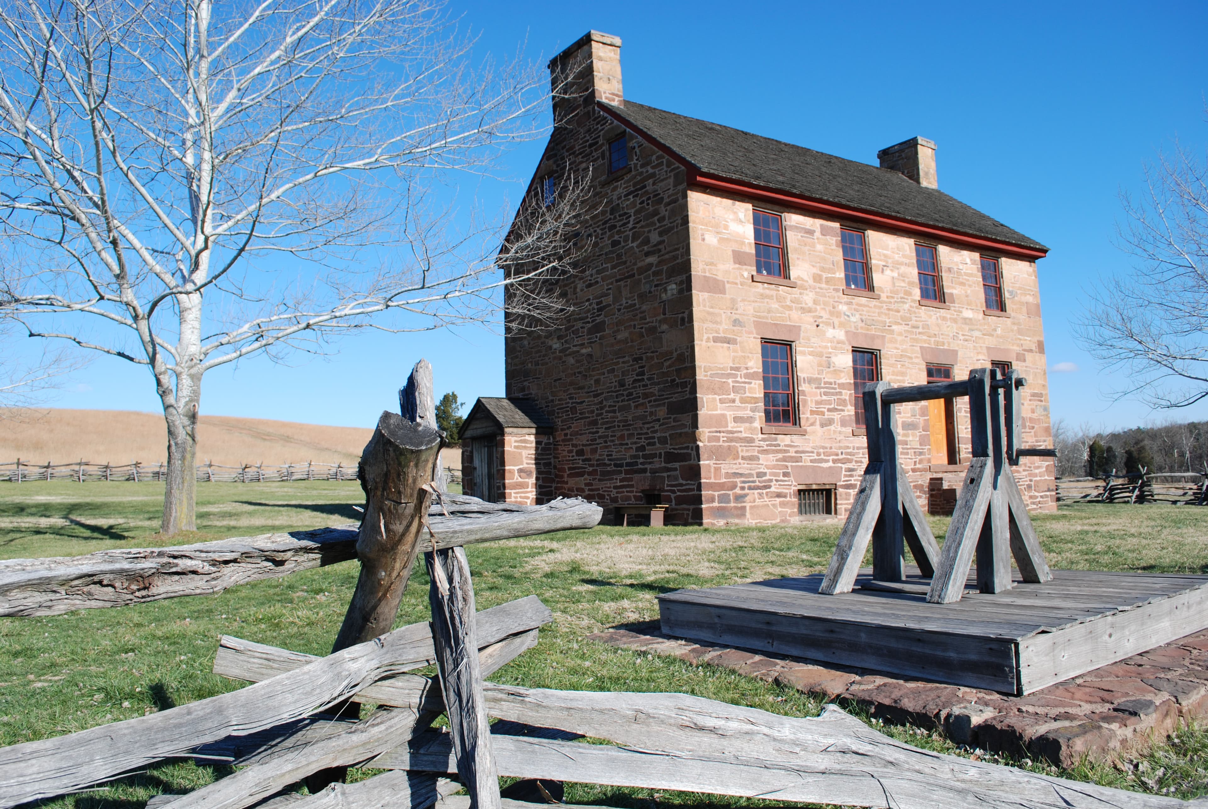
Auto Tour Stop #3: The Stone House
POIIn 1861 and again in 1862, this historic stone structure, was used as a makeshift hospital during and after the First and Second Battles of Manassas.
Auto Tour Stop #4: Matthews Hill
POIThe head of General Irvin McDowell's flanking column reached Matthews Hill shortly after 10 a.m.
Auto Tour Stop #5: Sudley
POIThroughout August 29, 1862, Federal troops repeatedly attacked Jackson's left flank - Gen. Maxcy Gregg's South Carolina Brigade - on a knoll just west of here.
Auto Tour Stop #6: Unfinished Railroad
POIThe Unfinished Railroad Grade served as the focal point of "Stonewall" Jackson's Confederate line during the Battle of Second Manassas.
Auto Tour Stop #7: Deep Cut
POIOn the afternoon of 30 August, 1862, Union General John Pope ordered an attack on "Stonewall" Jackson's position here at the Deep Cut.
Auto Tour Stop #8: Groveton
POIThe Bull Run and Groveton Ladies' Memorial Association, established in 1867, launched a campaign to recover Confederate dead from the battlefield. The organization established this cemetery and orchestrated the re-interment of an estimated 500 soldiers.
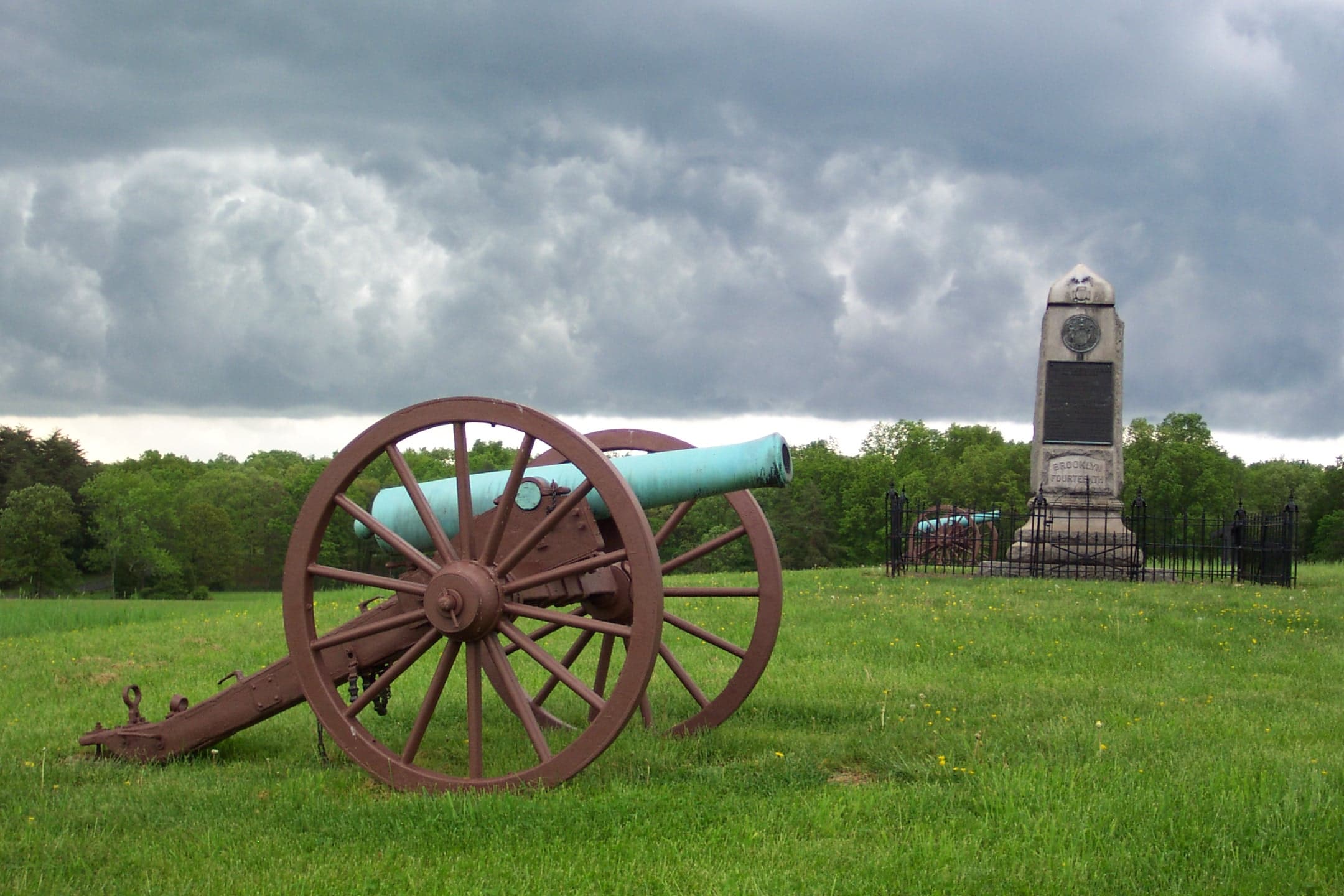
Auto Tour Stop #9: New York Monuments
POIIn 1906 the State of New York authorized the erection of three monuments on the field of the Second Battle of Manassas, honoring the sacrifices of the Fifth New York Volunteers, the Tenth New York Volunteers, and the Fourteenth Brooklyn.
Bartow Monument
POIThe monument marks the spot where Colonel Francis S. Bartow was mortally wounded leading the 7th Georgia Infantry during the First Battle of Manassas (Bull Run), July 21, 1861.
Bee Monument
POIBrownsville Picnic Area
POICaptain Charles Griffin's Howitzers
POICaptain James Ricketts' Artillery Position
POIUnion Captain James Ricketts' Battery I, 1st US Artillery held this position on the afternoon of 21 July 1861. Fighting raged along this line throughout the afternoon, with the guns changing hands three times. During the fighting, James Ricketts was severely wounded.
Carter Family Cemetery
POIConfederate Line on Henry Hill
POIDahlgren Boat Howitzers
POIDriving Tour Stop 1: Brawner Farm
POIOn August 28, 1862, Federal and Confederate soldiers clashed on the fields around the Brawner Farm.
Fletcher Webster Monument
POIGroveton Monument
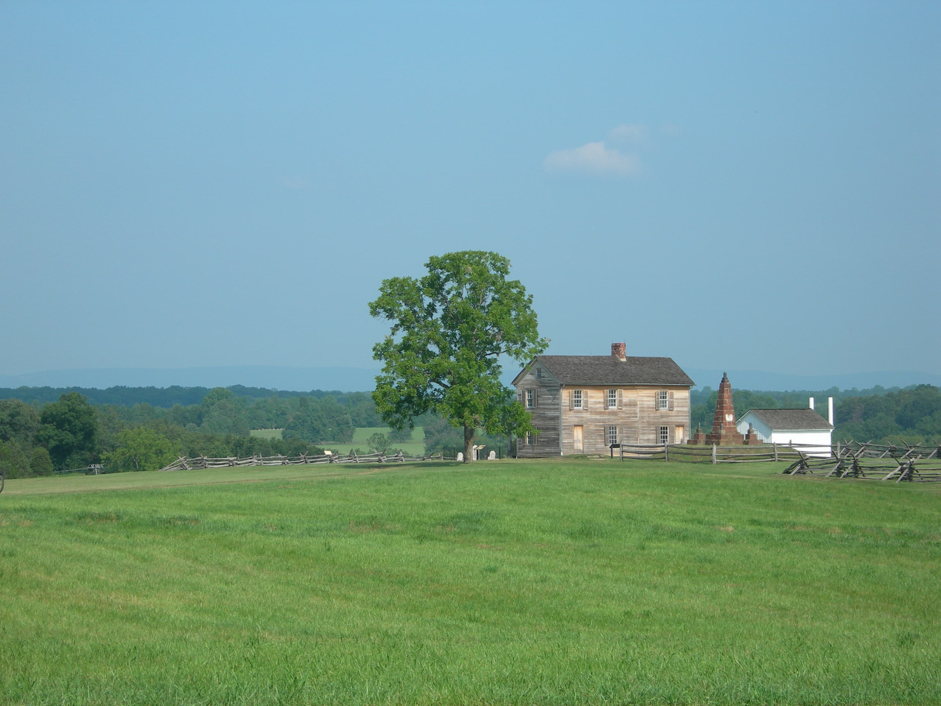
POIHenry House
POIImboden's Confederate Artillery
POIInformation Panel: Advancing Into the Woods
POIOriginally expected to attack over open ground west of the Groveton-Sudley Road (Featherbed Lane today), Grover shifted his brigade to the right of his initially assigned position and into these woods to mask his movement and avoid Confederate artillery fire.
Information Panel: Aftermath
POIFollowing the Union retreat, Lee remained determined to crush Pope. Again, he divided his army and sent Stonewall Jackson's troops on an encircling march to cut off the enemy's escape route to Washington.
Information Panel: A Stand Up Fight
POIUnion Brig. Gen. John Gibbon advanced through the woods with his men intent on driving off the Confederate artillery.
Information Panel: Battling For The Rocky Knoll
POIStonewall Jackson's defensive line extended nearly two miles- from Sudley Church to the Brawner Farm. Many of his 24,000 troops were posted behind the cuts and fills of the unfinished railroad grade before you.
Information Panel: Broken By Artillery
POIIn response to Stonewall Jackson's urgent request for support, General Robert E. Lee directed General James Longstreet to send reinforcements to bolster the Confederate line along the Unfinished Railroad, one-half mile ahead of you.
Information Panel: Carter Cemetery
POIOver 70 members of the Carter family rest in this cemetery- spanning multiple generations and two centuries of continuous ownership.
Information Panel: Charge Bayonets
POIGeneral John Pope arrived on the battlefield at 1 p.m. on August 29, 1862, with every expectation of defeating Stonewall Jackson.
Information Panel: Confederate Counterattack
POIGenerals Robert E. Lee and James Longstreet both concluded the moment had arrived to launch a massive Confederate offensive at Second Manassas.
Information Panel: Dahlgren Boat Howitzers
POIAs one of the first regiments to arrive in the nation's capital at the outbreak of war, the 71st New York State Militia received immediate orders from Gen. Winfield Scott to guard the Washington Navy Yard.
Information Panel: Death of Fletcher Webster
POIColonel Fletcher Webster fell mortally wounded near here, leading his regiment in support of the canon of Chinn Ridge.
Information Panel: Defending The Cannon
POIAs the Ohioans strived to delay the Confederates, Federal reinforcements rushed to Chinn Ridge in support. With these troops came the 5th Battery, Maine Light Artillery, under the temporary command of Lt. William F. Twitchell.
Information Panel: Farm Ford
POIColonel William T. Sherman spent the morning searching for a location suitable for this brigade to cross Bull Run.
Information Panel: Federal Breakthrough
POIAlthough the unfinished railroad grade provided a formidable defensive position, weakness existed in the Confederate line, putting some troops at risk. The low and marshy ground on which you stand was meant to be spanned by a railroad trestle.
Information Panel: Fight At The Fence Line
POIColonel Nathaniel McLean braced his men for the coming onslaught. The Union officer, a civilian attorney with no prewar military background, commanded 1,200 Ohioans on Chinn Ridge.
Information Panel: First Contact
POIThe head of General Irvin McDowell's flanking column reached Matthew's Hill shortly 10 a.m.
Information Panel: Hazel Plain
POIIn 1860, Benjamin Chinn and his family lived here in a two-and-a-half story frame farmhouse. Known as "Hazel Plain," the modest plantation comprised several hundred acres.
Information Panel: Historic Landscape Restoration
POIIn 1997 the National Park Service and the Smithsonian Institution began to develop a proposal at Manassas National Battlefield Park to mitigate the loss of wetlands resulting from construction of the Steven F. Udvar-Hazy Center, a National Air and Space Museum facility at Washington Dulles International Airport.
Information Panel: Jackson Opens Fire
POIObserving a column of tired, unsuspecting Federal troops marching eastward on the Western Pike (U.S. Rte. 29 today), General Thomas "Stonewall" Jackson chose to reveal his position and draw the Union Army of Virginia into battle on ground favoring the Confederates.
Information Panel: Lost Opportunity
POIYou are standing in the wartime Sudley Road. Twentieth-century Road realignments severed this short section and coincidentally preserved the historic trace.
Information Panel: On The Skirmish Line
POIThirty minutes before the main assault, Colonel Hiram Berdan's 1st U.S. Sharpshooters clambered over the fence along the Groveton-Sudley Road and dashed into the open pasture.
Information Panel: Opening Shots
POIFrom this ridge, Colonel Nathan G. Evans stood watch over the Stone Bridge, prepared to contest Union efforts to cross Bull Run.
Information Panel: Pittsylvania
POIThe foundation stones in front of you are all that remain of a once grand estate known as Pittsylvania.
Information Panel: Retreat From Chinn Ridge
POIColonel Oliver O. Howard's brigade brought up the rear of the Federal flanking column. After crossing Bull Run, the New Englanders hastened toward the sounds of battle. In the mid-afternoon heat, dozens of men straggled on the march or collapsed by the roadside. By the time they reached the front, Union hopes for victory were fading.
Information Panel: Shooting Gallery
POIOn the morning of August 30, 1862, Confederate Col. Stephen D. Lee deployed 18 guns from his artillery battalion along this commanding ridge.
Information Panel: Short Of Total Victory
POIIn the gathering dusk, the Confederate attack stalled due to exhaustion, heavy losses, and lack of needed reserves to exploit the momentary breakthrough.
Information Panel: Stone Bridge
POIAs the scene of the opening shots of the First Battle of Manassas and the retreat of Federals from the Second Battle of Manassas, the Stone Bridge witnessed the ebb and flow of Union fortune and misfortune in the two battles.
Information Panel: Sudley
POIOn the morning of July 21, 1861, Union troops crossed Bull Run at Sudley Ford.
Information Panel: The Battle Begins
POILate on the afternoon of August 28, Brig. Gen. Rufus King's division proceeded east toward Centreville.
Information Panel: The Battlefield of Manassas
POIManassas National Battlefield Park preserves and protects the land and resources associated with the First and Second Battles of Manassas and fosters understanding and appreciation of the significance of these battles by providing opportunities for public education, use, and inspiration.
Information Panel: The Fight for Matthews Hill
POIFighting opened here on Matthews Hill as Colonel Ambrose Burnside's brigade, leading the Union flanking column, collided with Confederates.
Information Panel: The Matthew Farm
POIIn 1860, Martin Matthew owned a modest frame house on 123 acres.
Information Panel: The Stovall Marker
POIThis stone is dedicated to the memory of Private George T. Stovall of the Rome Light Guards, 8th Georgia Infantry.
Information Panel: The Tide Crests
POIRobert Milroy's Union brigade occupied the washed-out bed of Sudley Road before you. Behind them, artillery occupied the crest of Henry Hill, in position to fire safely over the infantry.
Information Panel: The Van Pelt House
POIA native of New Jersey, Abraham Van Pelt arrived in Prince William County in the 1850s.
Information Panel: The Very Vortex of Hell
POIFrom their position atop this ridge, the soldiers of the 5th New York Infantry listened to the crash of battle.
Information Panel: Twilight Clash
POIWith his army reunited, Confederate General Robert E. Lee looked for an opportunity to strike the enemy. Lee proposed attacking the Federal left flank, which lay south of the Warrenton Turnpike.
Information Panel: Unfinished Railroad
POIDuring the 1850s, two local railroads- the Orange & Alexandria and the Manassas Gap- met at Manassas Junction.
Information Panel: Union Retreat-Strategic Crossing
POIFirst Battle of Manassas, July 21, 1861, 6 a.m. Second Battle of Manassas, Day Three, August 30, 1862, 9 p.m.
Lucinda Dogan House
POIThe small frame house stands as the only surviving original structure of the crossroad village of Groveton. The house was repeatedly caught in the crossfire of opposing Union and Confederate armies during the Second Battle of Manassas.
Matthew Farm Site
POIPatriots Monument
POIPittsylvania House Site
POIRobinson House Site
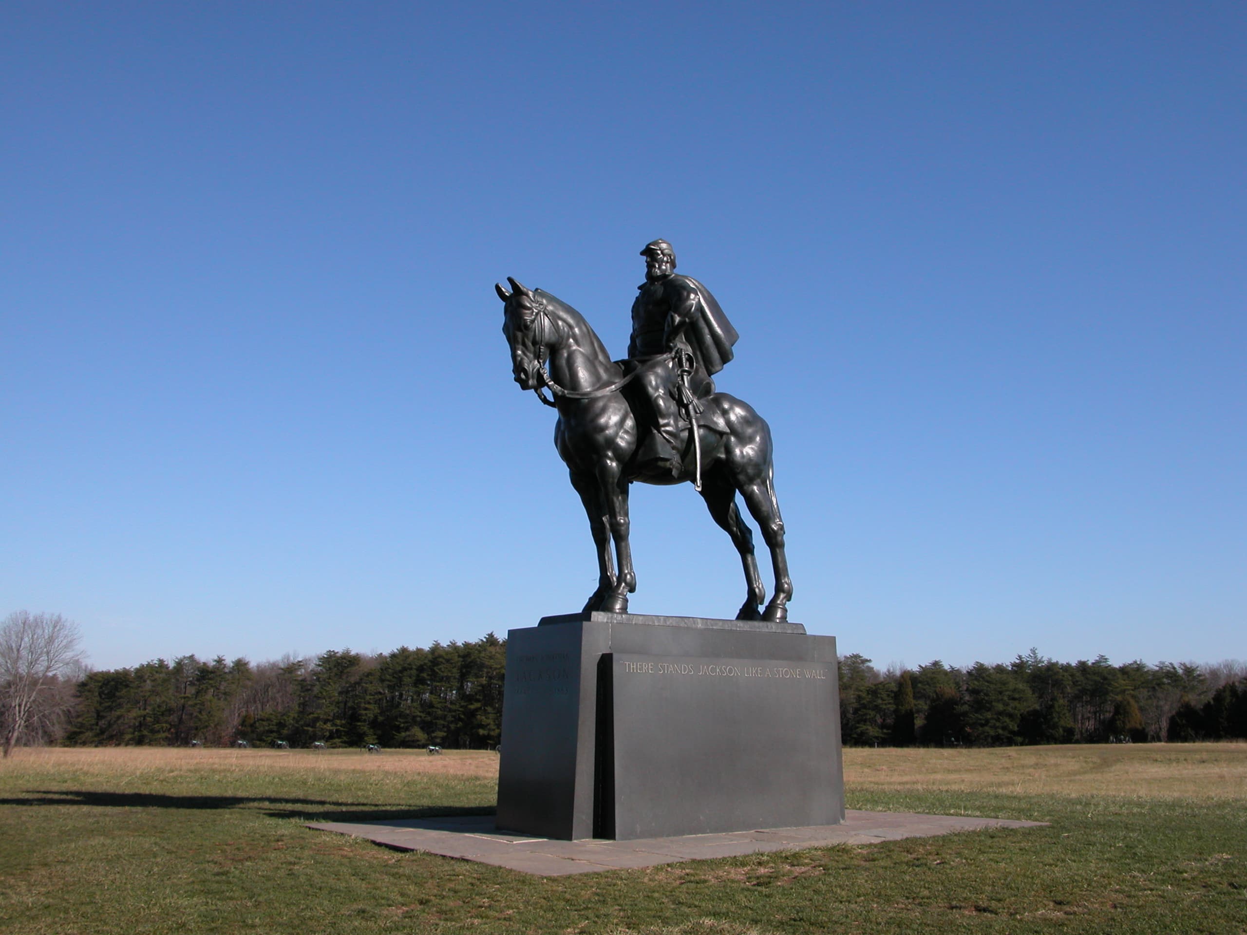
POIStonewall Jackson Monument
POITexas Monument
POIThe Fight at the Fenceline
POIThe Stovall Marker
POIThis marble marks the spot where fell George T. Stovall of the Rome Light Guards, 8th Regt. Georgia Volunteers in the battle of July 21, 1861. Born at Augusta, GA, April 25, 1835.
Thornberry House
POIThe Thornberry House survives as one of three Civil War-era structures in the park. Built in the 1840s it was home to John and Martha Thornberry and their five children.
Things to do
Brawner Farm Loop Trail
This trial traces the opposing lines of battle during the opening fighting of the Battle of Second Manassas on August 28, 1862.
Duration: 45-75 Minutes
Chinn Ridge Trail
Explore the grounds of Chinn Ridge that saw fighting at both First and Second Manassas. A paved path includes signage that explores the fighting in both battles. One way trail, must return along path to get back to parking lot.
Duration: 45-70 Minutes
First Manassas Trail
A 5.4 mile circuit hike where you can explore the First Manassas battlefield in detail.
Duration: 2-4 Hours
Henry Hill Loop Trail
The Henry Hill Loop is a easy 1.1 mile trail that encompasses the area of the most intense fighting during the First Battle of Manassas. Rickett's Battery, Jackson's Line, the Robinson Farm, and more are all part of this interpretive trail.
Duration: 30-90 Minutes
Matthews Hill Loop Trail
The Matthews Hill Loop is a .9 mile trail that explores the ground over which the opening shots of the Battle of First Manassas occurred.
Duration: 30-90 Minutes
Ranger's Choice Battlefield Walks
These programs examine unique portions of the battlefield landscape and story ranging from battle actions, civilian stories, and the memorialization of the park landscape. Programs may cross rough/uneven terrain. It is strongly recommended that visitors bring plenty of water, appropriate seasonal clothing, and sturdy hiking shoes.
Duration: 45-60 Minutes
Second Manassas Trail
This 6.6 mile loop trail explores key locations on the Second Manassas battlefield.
Duration: 3-4 Hours
Stone Bridge Loop Trail
The Stone Bridge Loop is a moderate 1.3 mile trail that follows along the Bull Run and explores the area where the first shots of the First Battle of Manassas were fired. Picturesque displays can be had along the trail of wildflowers in the spring and colorful foliage in the fall.
Duration: 45-60 Minutes
Sudley Loop Trail
The Sudley Road Loop is a .6 mile trail that takes visitors to one the few pre-war structures in the park, and the spot where 13,000 US troops crossed Bull Run on their way to the First Battle of Manassas.
Duration: 15-60 Minutes
Unfinished Railroad Loop Trail
Walk along a section of Jackson's line on the Unfinished Railroad where Federal soldiers momentarily breached the Confederate line on August 29, 1862.
Duration: 60-75 Minutes
Visitor centers
Brawner Farm Interpretive Center
Begin your exploration of the Second Battle of Manassas at the Brawner Farm Interpretive Center. Here you will find an electronic map which provides the story and troop movements of Second Manassas. Three rooms of exhibits provide information on the campaign and some of the personalities of Second Manassas, the civilian experience and the current Brawner farmhouse. This building is open seasonally from late spring through early fall. Check our calendar and guided tours webpage for tour information.
Get directionsHenry Hill Visitor Center
Begin your visit to the park at the Henry Hill Visitor Center. Here, you can pick up a park brochure, trail guide, or learn about the daily schedule of interpretive programs. A museum features artifacts related to the First and Second Battles of Manassas as well as a 6-minute electronic map showing the troop movements during the first battle. Walking tours of the fighting on Henry Hill are offered weekly. Check our calendar or guided tours webpage for current scheduled programs.
Get directions
Hours of operation
Manassas National Battlefield Park
The park is open daily from dawn until dusk.
Mon
Sunrise to Sunset
Tue
Sunrise to Sunset
Wed
Sunrise to Sunset
Thu
Sunrise to Sunset
Fri
Sunrise to Sunset
Sat
Sunrise to Sunset
Sun
Sunrise to Sunset
Activities
Weather
Spring: Mild weather, with average low/high temperatures from 33 F to 75 F. Variable rainfall, with May being the wettest month of the year on average. Summer: Warm and humid weather, with average temperatures from 61 F to 88 F. Variable rainfall, with occasional downpours during storms. Fall: Mild weather, with average temperatures from 35 F to 79 F. Variable rainfall. Winter: Mild to cool weather, with average temperatures from 24 F to 47 F. Annual snowfall averages about 22 inches.
Contact
Photos
Stay near this park
No horse-friendly stays listed near Manassas National Battlefield Park yet. Know a great barn or property? Help fellow riders by listing it.
List your propertyDirections
Located right off Interstate 66, just 26 miles west of Washington, DC.
Source: nps.gov