
Oregon National Historic Trail
ID · KS · MO · NE · OR · WA · WY · Baker City
Imagine yourself an emigrant headed for Oregon: would promises of lush farmlands and a new beginning lure you to leave home and walk for weeks? More than 2,000 miles of trail ruts and traces can still be seen along the Oregon National Historic Trail in six states and serve as reminders of the sacrifices, struggles, and triumphs of early American settlers.
Riding guide
Horses provided
Highlights
The Oregon National Historic Trail preserves the route used by 19th-century emigrants traveling west to the Willamette Valley.
Riding
Rideable terrain here is noted as Up to 125 miles, giving riders a clearer sense of scale before they ever unload. Unlike traditional park trails, the Oregon National Historic Trail is a historic corridor rather than a continuous riding trail. Today it passes through communities, public lands, farms, and preserved historic sites across several states, where visitors can experience individual trail segments and historic landscapes.
Rideable terrain
125 miles
Trailer parking
South Pass / Independence Rock Staging Area Location: Central Wyoming along WY-220 between Casper and Lander. Why riders use it Large open public land areas allow trailer staging Access to some of the longest preserved Oregon Trail segments in the country Connects to the South Pass riding segment, which includes long stretches of visible wagon ruts and historic trail corridors. Oregon Trail Road (Mills to Independence Rock) Location: Wyoming west of Casper along historic Oregon Trail Road. Why riders use it Access to roughly 41 Miles of historic trail corridor used by horseback riders Numerous roadside pullouts and dirt staging areas suitable for horse trailers Follows one of the best-preserved sections of the emigrant route. Three Island Crossing State Park Location: Glenns Ferry, Idaho along the Snake River. Why riders use it Large developed parking areas suitable for trailers Access to preserved Oregon Trail routes and viewpoints along the Snake River Historic interpretive center and trail access points nearby. Oregon Trail Recreation Area Location: Southeast of Boise, Idaho along the Snake River. Why riders use it Large parking lot with space for buses and trailers Access to historic trail viewpoints and open land suitable for riding nearby Good staging location for exploring preserved segments of the trail corridor. Blue Mountain Segment Trailheads Location: Near La Grande in northeastern Oregon. Why riders use it Access to roughly 17 Miles of preserved Oregon Trail segment through forest and mountain terrain Trailheads and forest access roads that accommodate horse trailers Historic trail corridor through the Blue Mountains. Barlow Road Trailheads Location: Mount Hood region of Oregon near the Barlow Pass area. Why riders use it Access to about 32 Miles of historic Barlow Road, the final Oregon Trail route into the Willamette Valley Forest service trailheads and dispersed staging areas used by equestrians Historic wagon road corridor through forested mountain terrain.
Horse regulations
Horseback riding along the Oregon National Historic Trail is allowed on certain preserved segments of the historic route where land managers permit equestrian use. The trail is a historic corridor rather than a single continuous trail, and it crosses a complex mix of federal lands, state lands, local parks, and private property. Because of this, horseback riding regulations vary depending on the agency or landowner responsible for each segment. Riders should check with the local land manager before visiting a specific portion of the trail. However, several core regulations and best practices generally apply for equestrians traveling along the trail corridor. Riding Is Only Allowed Where Access Is Permitted Horseback riding is allowed only on segments of the Oregon Trail where the land manager permits equestrian travel. Many sections of the historic route pass through private land, farms, highways, or protected historic sites where horseback access may not be allowed without permission. Travel on Established Routes Where riding is permitted, equestrians should remain on established trails, historic wagon routes, dirt roads, or designated public access corridors. Riding off-route in areas that could damage historic wagon ruts, archaeological features, or fragile soils is prohibited. Regulations Depend on the Managing Agency The Oregon Trail crosses lands managed by agencies such as the National Park Service, Bureau of Land Management, U.S. Forest Service, state parks, and local governments. Each land manager may have its own regulations regarding horse use, including trail access, permits, camping rules, and seasonal restrictions. Historic Resource Protection Many locations along the trail contain preserved wagon ruts, emigrant campsites, and historic artifacts. Collecting artifacts, disturbing historic features, or riding directly through fragile wagon ruts is not allowed. These features are protected cultural resources along the trail corridor. Feed and Invasive Species Control To help protect native ecosystems and historic landscapes, riders are encouraged to: Bring certified weed-free hay or feed Clean trailers, tack, and hooves before entering riding areas These practices help prevent the spread of invasive plant species along historic trail segments. Stock Control and Trail Courtesy Riders traveling along the Oregon Trail should: Maintain control of horses at all times Yield appropriately to other trail users where trails are shared Avoid damaging vegetation or historic features Follow local trail etiquette when encountering hikers, cyclists, or vehicles on shared routes. Remote Conditions and Self-Sufficiency Many rideable sections of the Oregon Trail cross remote landscapes such as prairie valleys, desert basins, and mountain passes. Riders should plan to be self-sufficient and bring adequate water, feed, and equipment for both horses and riders when exploring these areas.
Getting here
Use 22267 OR-86, Baker City, Oregon as your primary planning reference before you haul in. South Pass / Independence Rock Staging Area Location: Central Wyoming along WY-220 between Casper and Lander. Why riders use it Large open public land areas allow trailer staging Access to some of the longest preserved Oregon Trail segments in the country Connects to the South Pass riding segment, which includes long stretches of visible wagon ruts and historic trail corridors. Oregon Trail Road (Mills to Independence Rock) Location: Wyoming west of Casper along historic Oregon Trail Road. Why riders use it Access to roughly 41 Miles of historic trail corridor used by horseback riders Numerous roadside pullouts and dirt staging areas suitable for horse trailers Follows one of the best-preserved sections of the emigrant route. Three Island Crossing State Park Location: Glenns Ferry, Idaho along the Snake River. Why riders use it Large developed parking areas suitable for trailers Access to preserved Oregon Trail routes and viewpoints along the Snake River Historic interpretive center and trail access points nearby. Oregon Trail Recreation Area Location: Southeast of Boise, Idaho along the Snake River. Why riders use it Large parking lot with space for buses and trailers Access to historic trail viewpoints and open land suitable for riding nearby Good staging location for exploring preserved segments of the trail corridor. Blue Mountain Segment Trailheads Location: Near La Grande in northeastern Oregon. Why riders use it Access to roughly 17 Miles of preserved Oregon Trail segment through forest and mountain terrain Trailheads and forest access roads that accommodate horse trailers Historic trail corridor through the Blue Mountains. Barlow Road Trailheads Location: Mount Hood region of Oregon near the Barlow Pass area. Why riders use it Access to about 32 Miles of historic Barlow Road, the final Oregon Trail route into the Willamette Valley Forest service trailheads and dispersed staging areas used by equestrians Historic wagon road corridor through forested mountain terrain.
Planning your visit
Preparation and Access Considerations Riding segments of the Oregon National Historic Trail can be an incredible way to experience the landscapes pioneers once crossed, but planning requires more effort than a typical park trail ride. The trail corridor spans multiple states and jurisdictions, and infrastructure for horse travel varies widely. Riders should expect a mix of public lands, historic sites, and rural access roads rather than a single managed trail system. Permits and Land Access • There is no single permit covering the entire Oregon Trail. Requirements depend on the specific land manager where riders access the trail. • Many rideable segments cross lands managed by the Bureau of Land Management where day riding typically does not require a permit, though local regulations still apply. • Segments located in state parks, historic sites, or recreation areas may require park entrance fees or day-use passes. • Organized rides, guided trips, or large groups may require a special use permit depending on the managing agency. • Some visible trail segments pass through private ranchlands or farms. Riders must obtain permission before entering private land unless a public access route is clearly designated. Access and Trailer Logistics • Many trail access points are located on gravel or dirt roads that may be narrow, rough, or minimally maintained. Larger trailers should confirm road conditions before traveling. • Dedicated equestrian infrastructure is uncommon along much of the trail corridor. Riders often stage from BLM pullouts, trailheads, historic sites, or dispersed public land areas. • Some historic sites allow parking but may restrict where horse trailers can stage. Always follow posted signage. Water and Supplies • Water sources along the Oregon Trail can be limited or unreliable, particularly in Wyoming and Idaho desert sections. Riders should plan to bring all water needed for horses and riders. • Many trail segments are far from towns or services. Fuel, feed stores, veterinary care, and trailer repair facilities may be many Miles away. Backcountry Realities • Large portions of the Oregon Trail cross open plains and high desert landscapes where shade is minimal and summer temperatures can become extreme. • Sudden weather changes are possible, including thunderstorms and strong winds. • Cell service may be limited or nonexistent in many riding areas. Riders should carry navigation tools and emergency supplies. • Historic wagon ruts and archaeological features are fragile cultural resources. Riding directly on these features or disturbing artifacts is prohibited. RideJoy Planning Level Moderate to advanced planning recommended The Oregon Trail rewards riders who take time to research access points, confirm land management rules, and prepare for remote riding conditions. This is historic corridor exploration rather than a traditional managed trail system, and riders who plan ahead will have the best experience.
Where to stay
National Historic Oregon Trail Interpretive Center is the main visitor-contact point tied to this destination, which is helpful when you want current conditions, maps, and stock-use updates before riding. Guided or concession-based riding support is noted here, so riders who are not hauling their own horses may still find an access path into the experience. For a polished trip plan, pair the ride with lodging, fuel, and resupply planning in or near Baker City before heading deeper into federal-land access points.
Trails
No trails synced for this park yet.
Campgrounds
No campgrounds listed for this park.
Points of interest
Barlow Pass
POIBarlow Pass, at 4,160 ft., is the highest point on the Barlow Road. From this area, you can access the upper trailhead for the Pioneer Woman’s Grave Trail #485. This trail winds through conifer forest for about 1.2 miles to the Pioneer Woman’s Grave (3,720’ elev.). The path cuts across a broad, northerly bend in OR-35, following the territorial stage route across Barlow Pass and intersects portions of the original Barlow Road along the way.
Birch Creek Trail Site
POIBirch Creek Trail Site is a Bureau of Land Management site where the actual path made by emigrants, livestock, and wagons traveling the Oregon Trail is still a hiking path. Visitors are welcome to hike this quarter mile long section of the Oregon Trail across the sagebrush plains as it heads toward the Snake River.
Birnie Park
POIFor emigrants, today's Birnie Park was more than just a place along the Oregon Trail. It was also an important camping and staging area. In order to leave Grande Ronde Valley and continue on the Trail, emigrants faced a nearly 1000 ft. climb up steep valley walls. Teams of oxen had to be combined in order to pull the wagons up this rise. The area now known as Birnie Park provided a perfect location to do this.
Bonneville Point
POIBonneville Point is named for U.S. Army Captain Benjamin Bonneville, an early Idaho explorer whose party reached this viewpoint along an old Indian trail in 1833. Later, it became a fondly remembered location for emigrants on the Oregon Trail as they took in their first view of the Boise River Valley from the here. Trail ruts can be seen at this site.
Celilo Park
POILocation: I-84 exit 97, west of Biggs Junction, Oregon Celilo Park is located along a stretch of the Columbia River where American Indians have been fishing for at least 10,000 years. In the past, they netted salmon migrating up the rapids and over Celilo Falls for food and trade. This important fishery became the hub of a vast Indian trade network that one writer called "the Wall Street of the West."
Deschutes River State Park Oregon Trail Kiosk
POICrossing the Deschutes River, near Deschutes River State Park, was difficult for emigrants. They frequently camped at the mouth of this large tributary of the Columbia River before crossing. In order to cross, some emigrant parties used the rocky islands near the river's mouth as stepping stones, while wagons were floated across and stock animals swam.
Echo Meadows
POIThe primary route of the Oregon Trail passed through Echo Meadows from 1847-1860. Just four miles from the Umatilla River crossing, emigrants did not stop or camp here, but they left signs of their passing nonetheless. Deep wagon swales were created as the emigrants passed through the meadows, which remain to this day.
End of the Oregon Trail Interpretive Center
POIThe End of the Oregon Trail Interpretive Center contains a wealth of displays about the history of the Oregon Trail and the town of Oregon City. Before heading into the center, explore the outside grounds and gardens. Here, interpretive signs tell the stories of the Trail, the Tumwater Chinook and Clackamas Indian people, and the settlement of the Willamette Valley.
Farewell Bend State Recreation Area
POIFarewell Bend State Recreation Area is named after Farewell Bend, the last location where emigrants camped and watered along the banks of the Snake River after following the river for over 300 miles. The next morning they would turn northwest and head into the desolate Burnt River country. Restored covered wagons and exhibits at an Oregon Trail kiosk tell the story.
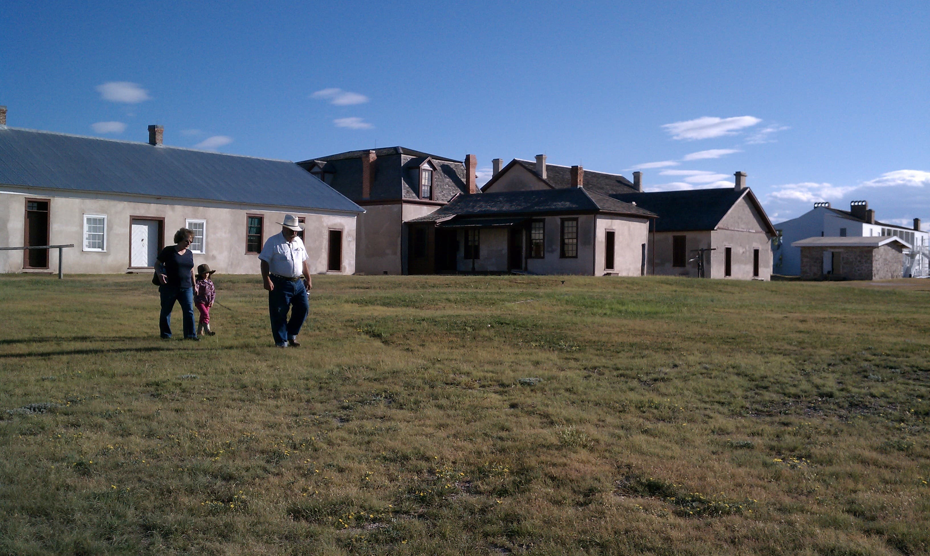
Fort Boise Site
POIFort Boise was a British trading post located at the junction of the Boise and Snake Rivers in what is now southwestern Idaho. While nothing remains of the fort, its location made Fort Boise significant to the settling of Oregon Country.
Grande Ronde Valley Oregon Trail Kiosk
POIThe kiosk's interpretive exhibits tell of the emigrant experience in the Grande Ronde Valley and their peaceful encounters with the valley's American Indians. Look back to the southeast (left side of the freeway when facing the westbound lanes of I-84) to see white posts marking the "powerful rockey" 1,300-foot descent of Ladd Hill.
Herrett Center for Arts & Science
POIThe Herrett Center for Arts and Science is a non-profit museum on the main campus of the College of Southern Idaho in Twin Falls, Idaho, USA. Its purpose is primarily educational, offering programs to elementary and secondary school students, CSI students, and the adult community of south-central Idaho. The Center collects, preserves, interprets, and exhibits anthropological artifacts and natural history specimens with an emphasis on the prehistoric American continents.
Historic Downtown Pocatello
POIVisit Historic Downtown Pocatello, Idaho along the Oregon National Historic Trail
Joel Hembree Grave
POIOn this private ranch west of Douglas, WY, are the graves of Joel Humbree, a child who died in a wagon accident on the way to Oregon, and Ralston Baker, a US soldier killed by Lakota in 1867. The site of the LaPrele Pony Express Station is nearby. Visitors must have landowner permission to enter the property.
Keeney Pass Interpretive Site
POIKeeney Pass was named for the early western pioneer, Jonathan Keeney. In 1831, at the age of 19, Keeney left Missouri to explore the Rocky Mountains. He joined Jim Bridger of the American Fur Company and spent his life trapping and trading throughout the west. Thousands of emigrants on the Oregon Trail used this pass to reach the fertile farmlands that laid further west.
Ladd Marsh Wildlife Area Overlook
POIFor emigrants on the Oregon Trail, Ladd Marsh was another obstacle they had to overcome in order to reach the fertile lands of the Willamette Valley. After traveling through Ladd Canyon and descending Ladd Hill, the flat lands of Grande Ronde Valley at first were a welcome reprieve from hard travel. But that changed upon entering the marsh.
Laurel Hill
POIFor the descent of Laurel Hill, immigrants locked their wagon wheels and dragged huge logs under their wagons to slow their slide down the 60 % grade. An informational sign and 1-mile roundtrip interpretive walk with a view of the precipitous Laurel Hill “chute” descent, is located at small pullout on Highway 26 near Government Camp.
Milner Historic Recreation Area
POIOver 100 years ago, emigrants on the Oregon Trail passed through what is now Milner Historic Recreation Area , creating ruts as they traveled through the soft soil of the area. Some of the emigrants chose to camp here, resting before continuing on the long journey ahead. The recreation area, managed by the Bureau of Land Management, preserves these still visible Oregon Trail ruts.
Milner Historic Recreation Area Swales
POIThe Oregon Trail ruts at Milner Historic Recreation Area cut across the loop road here in a couple of places. The shallow trough-like swale can be seen extending on both sides of the road through the grassy landscape dotted with sagebrush. Small white posts labeled "Oregon Trail" mark the position of the swale.
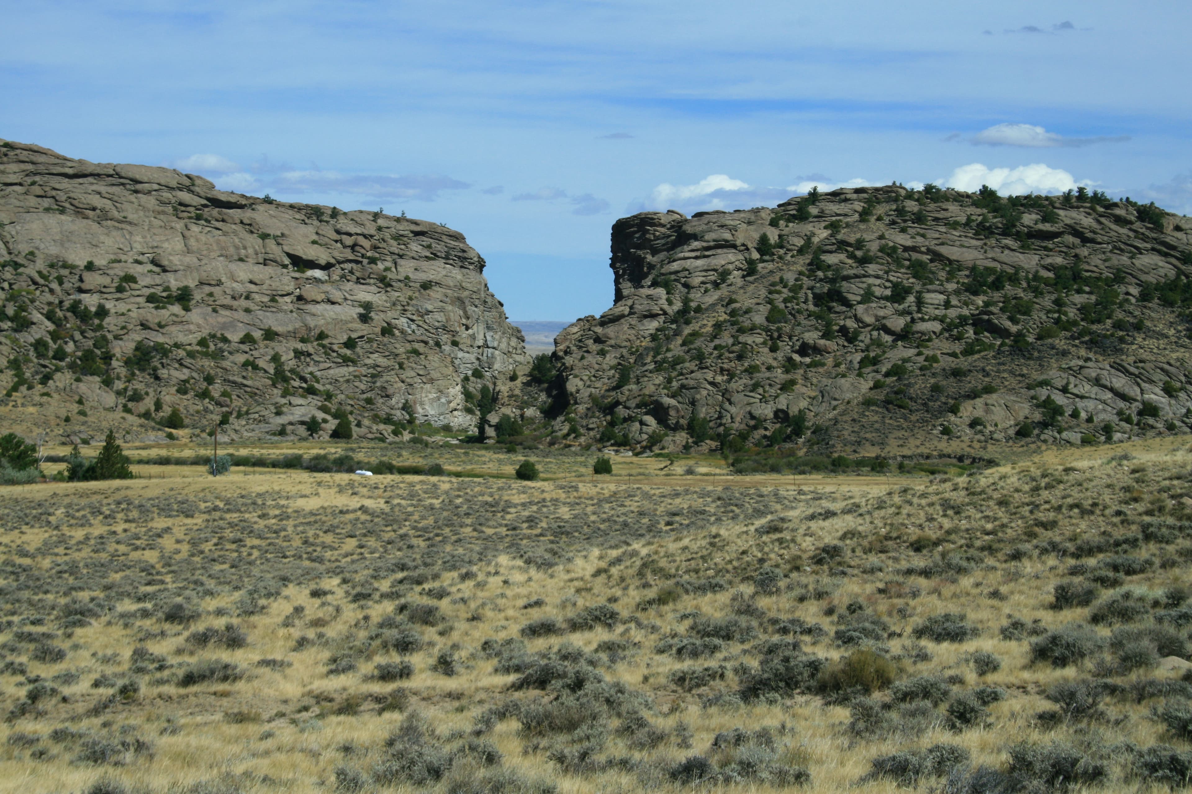
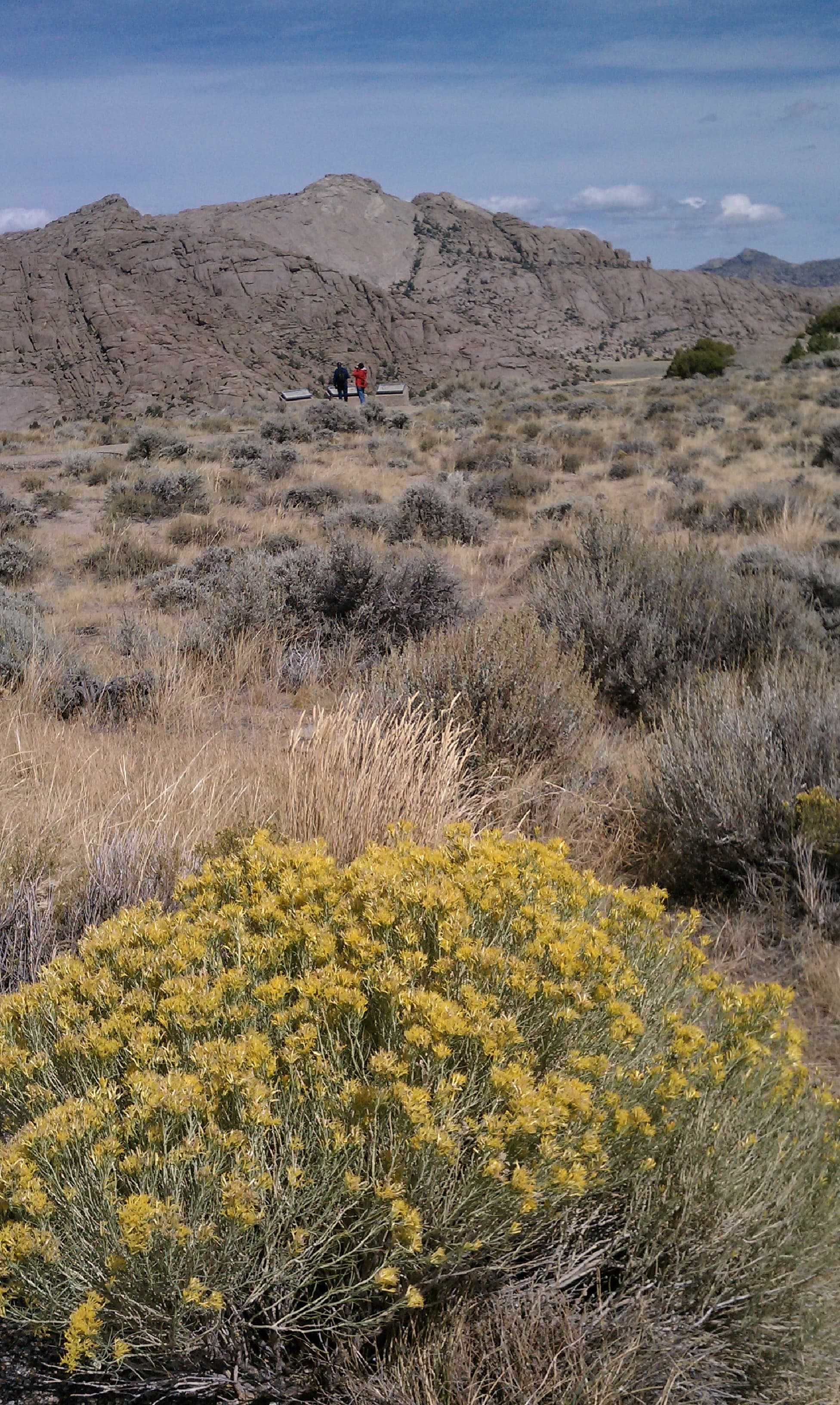
National Historic Oregon Trail Center- Trail Ruts
POIThe trek across Virtue Flats created 13 miles of still visible Oregon Trail ruts. Approximately one mile of these ruts lies on the interpretive center's grounds. The ruts can be reached by following hiking trails from the interpretive center or by driving a half-mile west of the center's entrance on Highway 86 to a turnout.
National Historic Oregon Trail Interpretive Center
POIThe National Historic Oregon Trail Interpretive Center is a 500-acre site managed by the Bureau of Land Management. The large interpretive center building contains exhibits that tell the compelling story of the Oregon Trail and the emigrant experience. View 13 miles of still visible Oregon Trail ruts. Approximately 1 mile of these ruts lies on the interpretive center's grounds.
Old Fort Boise Replica
POIVisit Old Fort Boise Replica in Parma, Idaho to experience Fort Boise, a critically important rest and resupply stop for Oregon Trail travelers in the early to mid-1800s. The Replica is a reproduction of the trading post known as Fort Boise and located about 7 miles from the site of the original Fort. A variety of amenities and things to do are found at the replica and in the surrounding Old Fort Boise Park.
Oregon National Historic Trail
POIImagine yourself an emigrant headed for Oregon: would promises of lush farmlands and a new beginning lure you to leave home and walk for weeks? More than 2,000 miles of trail ruts and traces can still be seen along the Oregon National Historic Trail in six states and serve as reminders of the sacrifices, struggles, and triumphs of early American settlers. This trail is administered by the National Trails Office Regions 6|7|8 in Santa Fe, New Mexico.
Oregon Trail Historic Reserve
POIOregon Trail Historic Reserve is a 77 acre site in Southeast Boise that contains original trail ruts. The Oregon Trail descended to the river about a half-mile to the east of this site, at a very steep, rocky location. The reserve contains a gravel pedestrian trail that follows the trail ruts as they head along the rim of scenic Boise Valley to the start of the descent.
Oregon Trail Interpretive Park at Blue Mountain Crossing
POIOregon Trail Interpretive Park at Blue Mountain Crossing is where the Oregon Trail passed through the rugged Blue Mountains. Knowing that this was the last mountain range they would cross must have helped emigrants find the strength to climb the Blue Mountains.
Oregon Trail Park Grave Site
POIFrom the Oregon Trail Park at Scott Springs parking lot, follow the one mile long, handicap accessible walking trail called "Little Dog Lost." It leads from the park, under the bridge, to the other side of the highway, and onto a grave site.
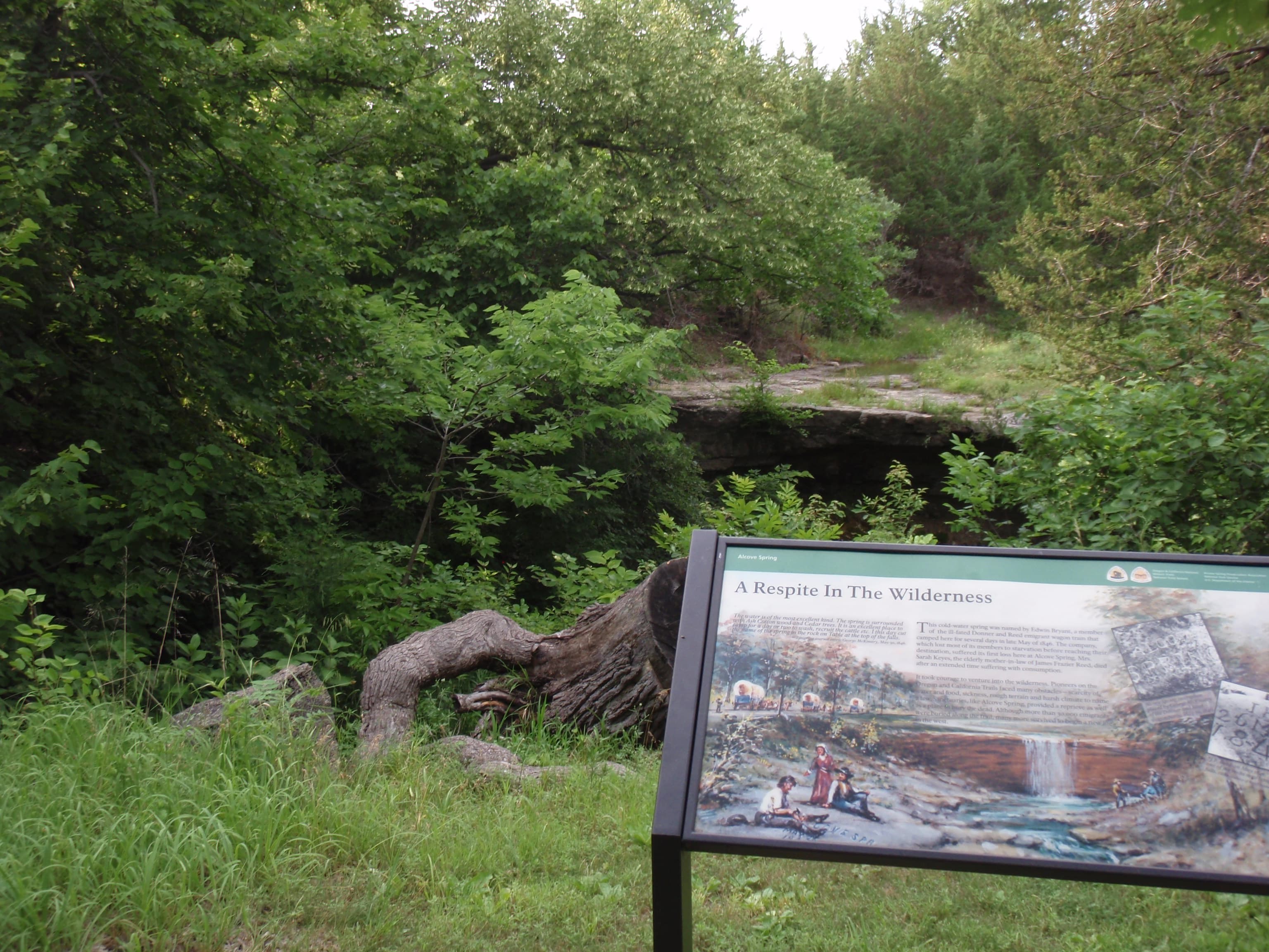
Pioneer Woman’s Grave and Trail
POIEngineers constructing the Old Mt. Hood Loop Highway found this forgotten trailside grave, hidden by vegetation, in 1924. An interpretive exhibit tells the story and a boulder with a plaque commemorates the unknown woman who died near here, just 50 miles from the Willamette Valley. The “grave trail” down from Barlow Pass approaches from the opposite side of the road.
Rachel E. Pattison Grave
POI"Rachel taken sick in the morning, died in the night." Thus did twenty-three-year-old Nathan Pattison record the death of his wife of two months, Rachel Warren Pattison, on the Oregon Trail. Her trailside grave was the beginning of this pioneer cemetery, now known as Ash Hollow Cemetery.
Rhododendron Tollgate
POIFinanced by businessman Philip Foster, Sam Barlow hired a road crew to improve his trail, which opened as a one-way toll road in 1846. The fifth and final tollgate on the turnpike operated here from 1883 to 1915. Interpretive signs tell the story. Nearby, a replica gate stands between two maple trees, which are believed to have been planted by one of the last tollgate keepers.
Rowena Crest Viewpoint
POIObtained as a gift from Mark Mayer in 1924, the Rowena Crest Viewpoint is a paved overlook located near the top of the high bluffs on the south side of the Columbia River. It offers magnificent views of the Columbia River Gorge, interpretive exhibits, and hiking trails through a nature preserve. When the spring wildflowers are in bloom, this is one of the most stunning vistas in the Gorge.
Tamástslikt Cultural Institute
POI"Tamástslikt " (pronounced "tuh-MUST-slickt") is from the Walla Walla Indian language, meaning "interpreting our own story." This museum and research facility is the only American Indian owned and operated interpretive center on the Oregon Trail. Its permanent exhibits explore the past, present, and future of the Cayuse, Umatilla, and Walla Walla people (the Confederated Tribes.)
The National Oregon/California Trail Center
POIThe National Oregon/California Trail Center offers visitors a unique and entertaining interpretive indoor adventure; simulating an actual wagon train experience of the 1850s. Re-enacted entirely within our comfortable center, this interpretive experience features historically accurate interpretive areas and live actors. Patrons will go back in time to visit a gun shop, mercantile, ride in a covered wagon and spend time around a wagon train.
Three Island Crossing Overlook
POIThree Island Crossing Overlook is located on top of the bluff across the river from Three Island State Park (directions available at the park's education center). 30 miles eastward from this spot, the Oregon Trail left the Snake River and traveled across dry plains until near the overlook, where once again the trail descended to the Snake River. Emigrants would then attempt to ford the river, a risky undertaking that not all of them survived.
Three Island Crossing State Park
POIThree Island Crossing was the most important and difficult river crossing in Idaho. Crossing the Snake River was always dangerous, but when the water was low enough to negotiate, everyone who could, forded the river here. This allowed emigrants to take the more favorable northern route to Fort Boise. If they were unable to cross, emigrants were forced to travel along the alternate south route into Oregon.
Whitman Mission National Historic Site, the Oregon Trail
POIWhitman Mission National Historic Site was established to preserve and share the story of Marcus and Narcissa Whitman's religious mission to the Cayuse Nation in the early nineteenth century, along with its lasting impacts and continuing relevancy. The Whitman's established their religious mission at Waiilatpu on the Columbia Plateau. During the 1840s, the mission also served as a way-stop on the Oregon Trail.
Things to do
Become an Oregon Trail Junior Ranger
Learn about the Oregon Trail and earn your junior ranger badge! This activity can be completed virtually or after visiting a site along the Oregon National Historic Trail. Worksheets can be submitted either electronically or by mail. Take a look and start exploring the trail today!
Check out Museums and Visitor Centers along the Oregon Trail
There are a variety of museums and visitor centers along the Oregon Trail. In some places, you may find more interpretive exhibits, information, and programs. In other places, being in the location will enrich your experience, even with minimal facilities. Visit one of these locations to learn more about the history and culture of the Trail.
Hike on the Oregon Trail
Imagine yourself an emigrant headed for Oregon: would promises of lush farmlands and a new beginning lure you to leave home and walk for weeks? Travel the Oregon National Historic Trail in six states and be reminded of the sacrifices, struggles, triumphs, and impacts of early American settlers. There are a variety of hiking opportunities across the full length of the trail. We've selected a few places in Oregon, Idaho, Nebraska, and Wyoming for you to check out.
Horseback Riding on the Oregon Trail
Take a ride back in time on the Oregon Trail! The variety of opportunities ranges from historic landscapes to modern views, and from short to longer trail rides. Riding the Trail is a great way to connect to this fascinating story, as your experience will serve as a reminder of the sacrifices, struggles, and triumphs of early American settlers.
Visitor centers
National Historic Oregon Trail Interpretive Center
The National Historic Oregon Trail Interpretive Center is managed by the Bureau of Land Management in Baker City, Oregon. The large interpretive center contains exhibits that tell the story of the Oregon Trail and the emigrant experience. In addition, the center contains a theater that hosts films, lectures, and dramatic presentations. On the grounds of the site are four miles of interpretive hiking trails, an amphitheater, a wagon encampment for living history demonstrations, and scenic views.
Get directions
Hours of operation
Oregon National Historic Trail
The Oregon National Historic Trail is not a clearly marked hiking trail. Instead it is a corridor that passes through communities, urban areas, public lands and Wilderness. The route travels across a variety of land ownerships and management, including private land. Each location varies as to the hours of operation and access. Please contact trail sites before your visit for more information.
Mon
All Day
Tue
All Day
Wed
All Day
Thu
All Day
Fri
All Day
Sat
All Day
Sun
All Day
Activities
Weather
Due to the length of the Oregon National Historic Trail, be sure to consult local weather sources for the region you'll be visiting. Check out the forecast with the National Weather Service and search for the area you'd like to visit: weather.gov
Contact
Photos
Stay near this park
No horse-friendly stays listed near Oregon National Historic Trail yet. Know a great barn or property? Help fellow riders by listing it.
List your propertyDirections
More than 2,000 miles of trail ruts and traces can still be seen along the Oregon National Historic Trail in six states- reminders of the sacrifices, struggles, and triumphs of early American settlers.
Source: nps.gov