
Caution
Feral Dogs May Be Seen in Organ Pipe Cactus National Monument
Feral dogs may be present at the Twin Peaks Campground and around the Kris Eggle Visitor Center. Visitors should not attempt to feed or water these dogs or approach them in any way as they may carry disease or become hostile.
Caution
Pozo Nuevo Road to Bates Well Ranch High Clearance, 4-Wheel Drive Only
High Clearance, 4-wheel drive is required from where Pozo Nuevo Road begins along South Puerto Blanch Drive to Bates Well Ranch area. The road is washed out in areas. Bates Well Ranch is still accessible from the north on Darby Well Road.
Organ Pipe Cactus National Monument
AZ · Ajo
Look closely. Look again. The sights and sounds of Organ Pipe Cactus National Monument, an International Biosphere Reserve, reveal a thriving community of plants and animals. Human stories echo throughout the Sonoran Desert, chronicling thousands of years of desert living. A wilderness hike, a scenic drive, or a night of camping will expose you to a living desert abounding with hidden life.
Riding guide
Highlights
Organ Pipe Cactus National Monument protects a remarkable stretch of the Sonoran Desert where organ pipe cactus, rare…
Riding
Rideable terrain here is noted as 60-80 miles, giving riders a clearer sense of scale before they ever unload. While trail riding opportunities are not as formalized as in forested or mountainous parks, riders who bring their own horses can explore Miles of primitive roads, washes, and multi-use backcountry corridors where stock travel is permitted. The landscape is rugged, exposed, and ecological sensitive, requiring thoughtful planning, heat awareness, and adherence to Leave No Trace principles.
Rideable terrain
60-80 miles
Trailer parking
Twin Peaks Campground Area This is usually the most practical location to stage a horse trailer. Why riders use it Large developed campground with vehicle and trailer parking Sites and roads that can accommodate larger rigs (some up to about 45 feet) Close to several horse-permitted trails such as the Campground Perimeter Trail, Lost Cabin Mine Trail, and Old Country Road Trail Located near the main visitor center, making it easy to check conditions or permits Many riders either park in the campground or use nearby pull-outs to begin rides. Victoria Mine Trailhead Area Another commonly used staging location. Features Small trailhead parking area with restroom and water available nearby Access to the 4.5-mile Victoria Mine equestrian trail Good option for shorter day rides Scenic Backcountry Road Pullouts Because much of the monument is open desert with primitive roads, riders sometimes stage from: Ajo Mountain Drive pullouts Puerto Blanco Drive backcountry road areas These locations provide access to remote desert riding but have no horse facilities, so they are best suited for experienced riders comfortable with primitive staging.
Horse regulations
Horse Use Regulations Where Horses Are Allowed Horses and other stock animals are permitted on designated roads, backcountry routes, and approved areas within the monument. Cross-country travel is not allowed. Travel should remain on existing roads and washes where stock use is permitted. Horses are not allowed on hiking-only nature trails or in developed visitor areas. Permits A backcountry permit may be required for overnight camping with stock. Check with the monument’s visitor center before planning an overnight trip. Day riding does not typically require a permit. Feed and Grazing Loose hay and grain are prohibited. Certified weed-free feed is required. Supplemental feed such as pellets or cubes should be used. Grazing is not permitted in order to protect fragile desert vegetation. Feed must not be scattered on the ground. Securing Animals Stock must be secured in a way that prevents damage to vegetation and soil. Avoid tying directly to small trees or desert plants. Keep animals away from water sources and sensitive riparian areas. Group Size and Animal Types Horses, mules, burros, and llamas are permitted. Other livestock types are not allowed. Group size limits may apply for overnight backcountry use. Environmental Protection Desert soils are extremely fragile and slow to recover. Stay on established routes to prevent erosion and plant damage. Manure should be removed from staging and parking areas. Developed Trail Rides There are plenty of trails for horseback riding in the monument! The following is a list of trails that are are open for equestrian use, each with varying lengths and difficulty. As always, horse use is allowed in the federally designated Wilderness sections of Organ Pipe Cactus. Victoria Mine Trail 4.5 Miles roundtrip easy trail Restroom and water available at trailhead in campground Lost Cabin Mine Trail 8 Miles roundtrip Facilities at beginning of trail in campground Campground Perimeter Trail one mile loop easy trail water and restrooms available along the route in the campground Old County Road Trail 16 Miles roundtrip Easy Trail No facilities Senita Basin Loop 1.2 Miles roundtrip Moderate trail No facilities Milton Mine Trail 3.2 Miles roundtrip Difficult trail no facilities Red Tanks Tinaja Trail 1.6 Miles roundtrip moderate trail no facilities
Getting here
Use 10 Organ Pipe Drive, Ajo, Arizona as your primary planning reference before you haul in. Twin Peaks Campground Area This is usually the most practical location to stage a horse trailer. Why riders use it Large developed campground with vehicle and trailer parking Sites and roads that can accommodate larger rigs (some up to about 45 feet) Close to several horse-permitted trails such as the Campground Perimeter Trail, Lost Cabin Mine Trail, and Old Country Road Trail Located near the main visitor center, making it easy to check conditions or permits Many riders either park in the campground or use nearby pull-outs to begin rides. Victoria Mine Trailhead Area Another commonly used staging location. Features Small trailhead parking area with restroom and water available nearby Access to the 4.5-mile Victoria Mine equestrian trail Good option for shorter day rides Scenic Backcountry Road Pullouts Because much of the monument is open desert with primitive roads, riders sometimes stage from: Ajo Mountain Drive pullouts Puerto Blanco Drive backcountry road areas These locations provide access to remote desert riding but have no horse facilities, so they are best suited for experienced riders comfortable with primitive staging.
Planning your visit
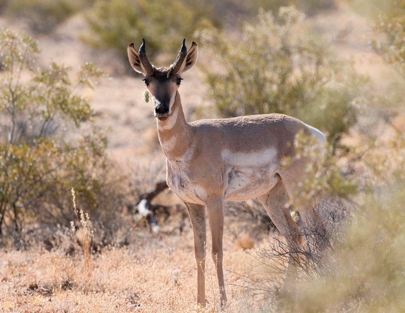
Must Know Before You Ride • This is extreme desert. Summer temperatures regularly exceed 100°F. Riding is safest in late fall through early spring. Plan early morning outings and monitor both horse and rider hydration closely. • There is very limited natural water. Do not rely on water sources in the monument. Bring sufficient water for both you and your horse. • Shade is minimal. Expect full sun exposure for most routes. Protective gear and heat management are essential. • Desert footing varies. You may encounter deep sand, rocky volcanic terrain, and sharp desert plants. Condition your horse accordingly and consider hoof protection if needed. • The monument borders Mexico. Expect Border Patrol presence and occasional vehicle checkpoints when entering or leaving the area. • Cell service is extremely limited. Download maps ahead of time and share your itinerary before departure. • Services are sparse. Fuel, feed, and supplies are not widely available near the monument. Plan to be self-sufficient. • Desert vegetation is fragile and slow to recover. Stay strictly on established roads and approved routes. • Wildlife includes rattlesnakes, javelina, and desert predators. Stay alert, especially in warmer months.
Where to stay
Kris Eggle Visitor Center is the main visitor-contact point tied to this destination, which is helpful when you want current conditions, maps, and stock-use updates before riding. Horse camping is allowed, so this destination can work as more than a quick in-and-out ride if you want to build a longer federal-land stay around it. For a polished trip plan, pair the ride with lodging, fuel, and resupply planning in or near Ajo before heading deeper into federal-land access points.
Entrance fees & passes
- $25.00
Entrance - Private Vehicle
Valid for 7 days. This fee includes all occupants of a non-commercial vehicle.
- $20.00
Entrance - Motorcycle
Valid for 7 days. Admits up to 2 private, non-commercial motorcycles with up to 4 total passengers.
- $15.00
Entrance - Per Person
Valid for 7 days. This fee applies to bicycles and walk-ins (per person)
- $45.00
Annual Entrance - Park
This pass is valid for Organ Pipe Cactus National Monument for one year from the month of purchase. The pass admits all passengers in a private vehicle and is non-transferable.
- $45.00
Annual Entrance - Park
This pass is valid for Organ Pipe Cactus National Monument for one year from the month of purchase. The pass admits all passengers in a private vehicle and is non-transferable.
Trails
No trails synced for this park yet.
Campgrounds
Alamo Canyon Campground
4 sites
Alamo Canyon Campground is a secluded, four-site campground nestled against rocky mountains at the mouth of Alamo Canyon. This primitive campground features picnic tables, grills, a tent area at each site, and a vault toilet located near bulletin boards. It is only for tent camping or small car camping; no RVs, trailers or generators are allowed.
Reserve a siteTwin Peaks Campground
208 sites
Twin Peaks Campground is the main, developed campground at Organ Pipe Cactus National Monument, located 1.5 miles from the Kris Eggle Visitor Center and Highway 85. Twin Peaks Campground has 34 tent-only sites and 174 sites for RVs, and several sites can accommodate RVs up to 45 feet in length. Restrooms have running water and some have solar-heated showers. Hookups for electricity, water, or sewer are not available. A dump station, with potable water is located past the last row of campsites.
Reserve a site
Points of interest
Ajo Mountain Drive Stop 1
POIAjo Mountain Drive Stop 10
POIAjo Mountain Drive Stop 11
POIAjo Mountain Drive Stop 12
POIAjo Mountain Drive Stop 13
POIAjo Mountain Drive Stop 14
POIAjo Mountain Drive Stop 15
POIAjo Mountain Drive Stop 16
POIAjo Mountain Drive Stop 17
POIAjo Mountain Drive Stop 18
POIAjo Mountain Drive Stop 2
POIAjo Mountain Drive Stop 3
POIAjo Mountain Drive Stop 4
POIAjo Mountain Drive Stop 5
POIAjo Mountain Drive Stop 6
POIAjo Mountain Drive Stop 7
POIAjo Mountain Drive Stop 8
POIAjo Mountain Drive Stop 9
POIGachado Line Camp
POIA restored adobe line camp used by the Gray family during the once vast cattle ranching era of the mid 1900s. Visitors can witness the resourcefulness of Sonoran Desert ranchers in the construction and use of native materials in the line camp, but can also view the effects of overgrazing on the surrounding landscape.
Pinkley Peak
POIThe colorful Pinkley Peak is the highest peak in the Puerto Blanco Mountains. This peak is affectionately named for National Park Service Ranger and Superintendent, Frank “Boss” Pinkley. Nested at the base of the peak are covered picnic areas and restrooms.
Quitobaquito Springs
POIAs a natural spring leading to a human constructed pond, Quitobaquito has been used by people for over 16,000 years. The area has a rich history and is an important part of the cultural landscape of the O’odham people. Quitobaquito is also home to several endangered species, including the Quitobaquito Pupfish and the Sonoyta Mudturtle.
Things to do
Become a Desert Ranger
For the 'Not-so-Junior-Ranger," or those looking for a challenge, the free Desert Ranger program allows the young at heart to earn their Desert Ranger badge and patch by completing an activity booklet available at the visitor center.
Duration: 30-120 Minutes
Become an Organ Pipe Junior Ranger
Become a Junior Ranger at Organ Pipe Cactus National Monument.
Duration: 30-120 Minutes
Birding at Organ Pipe
Organ Pipe sits along a primary migratory flyway, creating an oasis for bird enthusiasts of all levels. In addition to hosting an exciting array of migratory birds during fall and spring, we also have 36 species of resident birds that can be found year round at Organ Pipe.
Drive South Puerto Blanco Road
South Puerto Blanco Drive is a two-way, graded dirt road that follows the southern boundary of the park and provides access to Senita Basin and Quitobaquito Springs. Great examples of organ pipe, senita, and saguaro cacti are visible along this route. This road can be washboarded – reduce your speed and allow extra time. These roads are doable in a normal passenger car. Trailers, buses, and motorhomes over 25 feet (8 meters) are prohibited on the drive.
Duration: 2-3 Hours
Drive the Ajo Mountain Loop
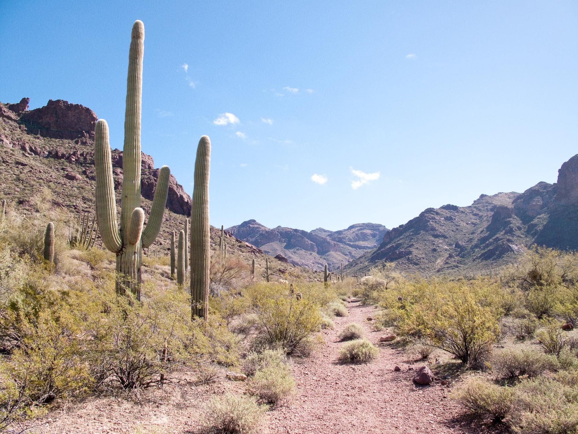
The Ajo Mountain Drive is a 21-mile (34 km) graded, one-way dirt road that gives visitors an excellent overview of the landscape and flora or Organ Pipe Cactus National Monument. The drive takes approximately 2 hours, and has been designed so that a passenger car, driven with caution, may be taken over it safely. Trailers, buses and RVs over 25 ft (8 m) are prohibited on the drive. Several hikes and backcountry camping can be accessed from this drive.
Duration: 2-5 Hours
Drive the North Puerto Blanco Loop
For those looking for a longer, more rugged scenic drive through Organ Pipe, Puerto Blanco Drive is a great way to experience some of the park’s volcanic geology, mining history, and natural springs. The 41 mile Puerto Blanco Loop is broken into two parts: North Puerto Blanco Drive and South Puerto Blanco Drive.
Hike Alamo Canyon
The Alamo Canyon Trail follows an old road to a historic ranch house and corral, and provides ample wildlife and wildflower viewing opportunities.
Duration: 1-2 Hours
Hike Arch Canyon
One of the most photographed sites along the Ajo Mountain Drive are the double arches carved into the mountains. Walking the easy, relatively flat Arch Canyon trail provides wonderful opportunities to see wildflowers and gaze upon the rhyolite arches.
Duration: 60-90 Minutes
Hike the Estes Canyon/Bull Pasture Loop
The moderate Estes Canyon trail provides ample wildlife and wildflower viewing opportunities while a steep, strenuous climb up the Bull Pasture spur trail will reward visitors with spectacular views of the Sonoran Desert.
Duration: 1-3 Hours
Hike the Historic Old County Road!
Enjoy scenic views along an 8-mile one-way hike as you explore a historic wagon road through the Sonoran Desert!
Duration: 3-5 Hours
Hike the Senita Basin Loop
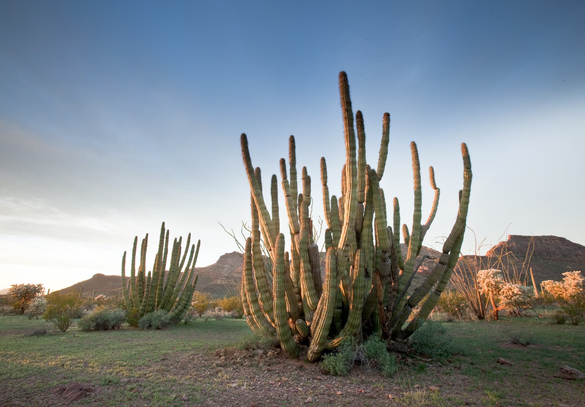
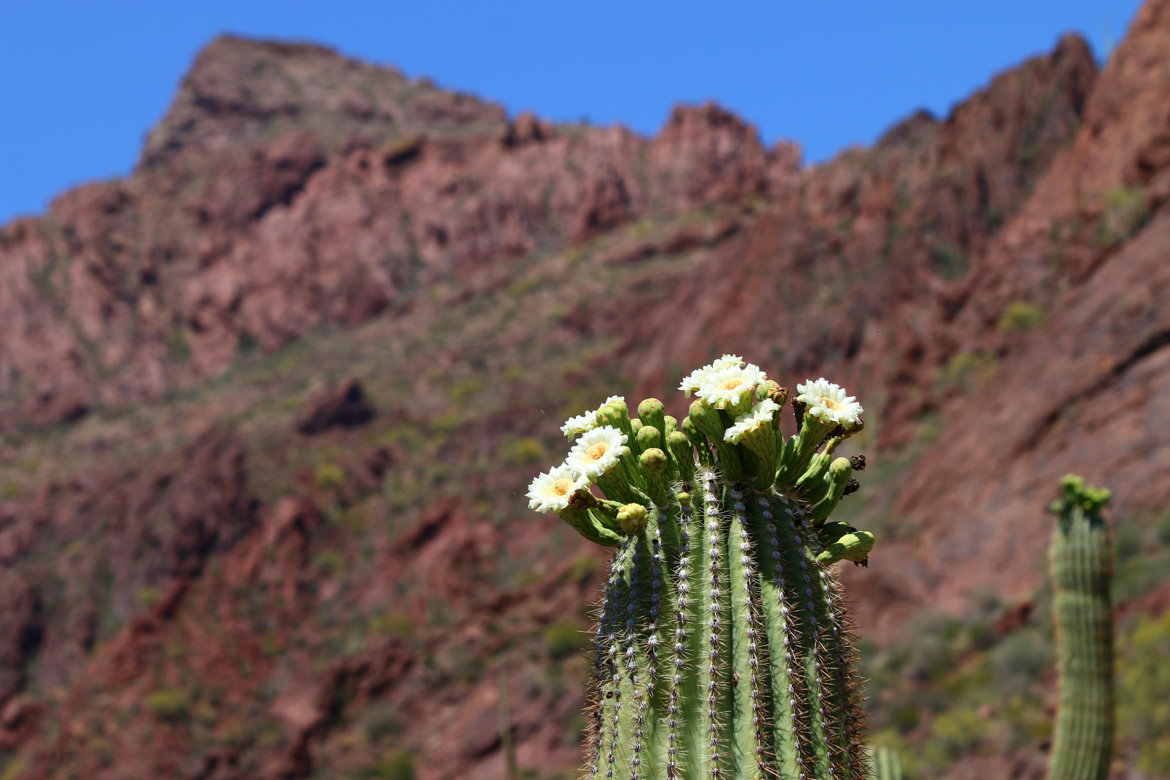
Easy loop trail located in a low elevation area on the south side of the Puerto Blanco Mountains. This lush basin is one of the few places you can see all three of the park’s columnar cacti coexisting: saguaro, organ pipes, and the senita cacti. The most impressive groves of senita cacti are along the road into Senita Basin and near the trailhead.
Duration: 2-3 Hours
Hike to Lost Cabin
Looking for a lengthier hike that showcases Organ Pipe’s mining history? This 8 mile (12.9 kilometers) round-trip hike includes the Victoria Mine site and an old stone mining house known as Lost Cabin.
Duration: 4-5 Hours
Hike to Victoria Mine
Experience Organ Pipe’s mining history by hiking to Victoria Mine, one of the oldest prospecting sites in southwest Arizona and the heart of gold and silver mining in the Organ Pipe area.
Duration: 3-4 Hours
See Endangered Pupfish Along the Visitor Center Nature Trail
Next to the Kris Eggle Visitor Center is a 1/10th of a mile paved nature trail that loops by a small pond and showcases native Sonoran Desert plant life. The trail begins by the back door of the visitor center and loops back around to the parking lot.
Duration: 15-30 Minutes
Stargazing at Organ Pipe
Take advantage of our monument's dark skies to do some stargazing and astrophotography, or join in on a night sky ranger program.
Stretch Your Legs on the Campground Perimeter Trail
This short, dog-friendly trail circles Twin Peaks Campground and is ADA accessible in areas!
Duration: 30 Minutes
Unearth Dripping Springs Mine
Stumble upon an old copper mine while exploring along the trail in the Puerto Blanco Mountains!
Duration: 2-3 Hours
Walk Your Pet along Palo Verde Trail
Easy, pet-friendly trail that connect the Kris Eggle Visitor Center to Twin Peak Campground. Provides beautiful views of the Ajo Mountains.
Duration: 90-120 Minutes
Watch the Sunset from Desert View Trail
Searching for that quintessential desert sunset? The Desert View trail has your back! This short, 1.2 mile (1.9 km) can be reached from Twin Peaks Campground and loops around striking stands of organ pipe cacti. The Desert View trail offers great views for sunrise or sunset.
Duration: 30-60 Minutes
Visitor centers
Kris Eggle Visitor Center
The Kris Eggle Visitor Center is a great place to start your visit at Organ Pipe Cactus. Rangers there provide orientation to the monument, answer questions, and offer suggestions on how to best enjoy your experience during your time here. Inside is an information desk with maps and guides, an exhibit area where visitors may learn about the Sonoran Desert, and a bookstore. A short nature trail starting behind the visitor center features Quitobaquito pupfish and signs about the life found in the monument.
Get directions
Hours of operation
Organ Pipe Cactus National Monument
The monument is open 365 days a year and park roads and trails are open 24 hours. There is no gate at the monument entrance; entrance fees are paid for at the visitor center. There is no dispersed camping allowed anywhere in the monument. US-Mexico Border hours are 6 am-8 pm. The main season for visitors is December through the end of April, during the mild winter months and wildflower season. Campgrounds may fill during this time; check Recreation.gov for campsite availability.
Mon
All Day
Tue
All Day
Wed
All Day
Thu
All Day
Fri
All Day
Sat
All Day
Sun
All Day
Activities
Weather
Summer months are hot, with temperatures exceeding 100F during the day and night-time temperatures in the high 70's. Winter months are milder, with temperatures in the 70s during the day and 30's to 40's in the evening.
Contact
Photos
Stay near this park
No horse-friendly stays listed near Organ Pipe Cactus National Monument yet. Know a great barn or property? Help fellow riders by listing it.
List your propertyDirections
The Kris Eggle Visitor Center is located on Highway 85 approximately 25 miles south of Why, AZ and 5 miles north of Lukeville, AZ, just before the US-Mexico Border.
Source: nps.gov