
Pony Express National Historic Trail
CA · CO · KS · MO · NE · NV · UT · WY · St Joseph
It is hard to believe that young men once rode horses to carry mail from Missouri to California in the unprecedented time of only 10 days. This relay system along the Pony Express National Historic Trail in eight states was the most direct and practical means of east-west communications before the telegraph.
Riding guide
Highlights
The Pony Express National Historic Trail follows the historic mail route used by the Pony Express between St.
Riding
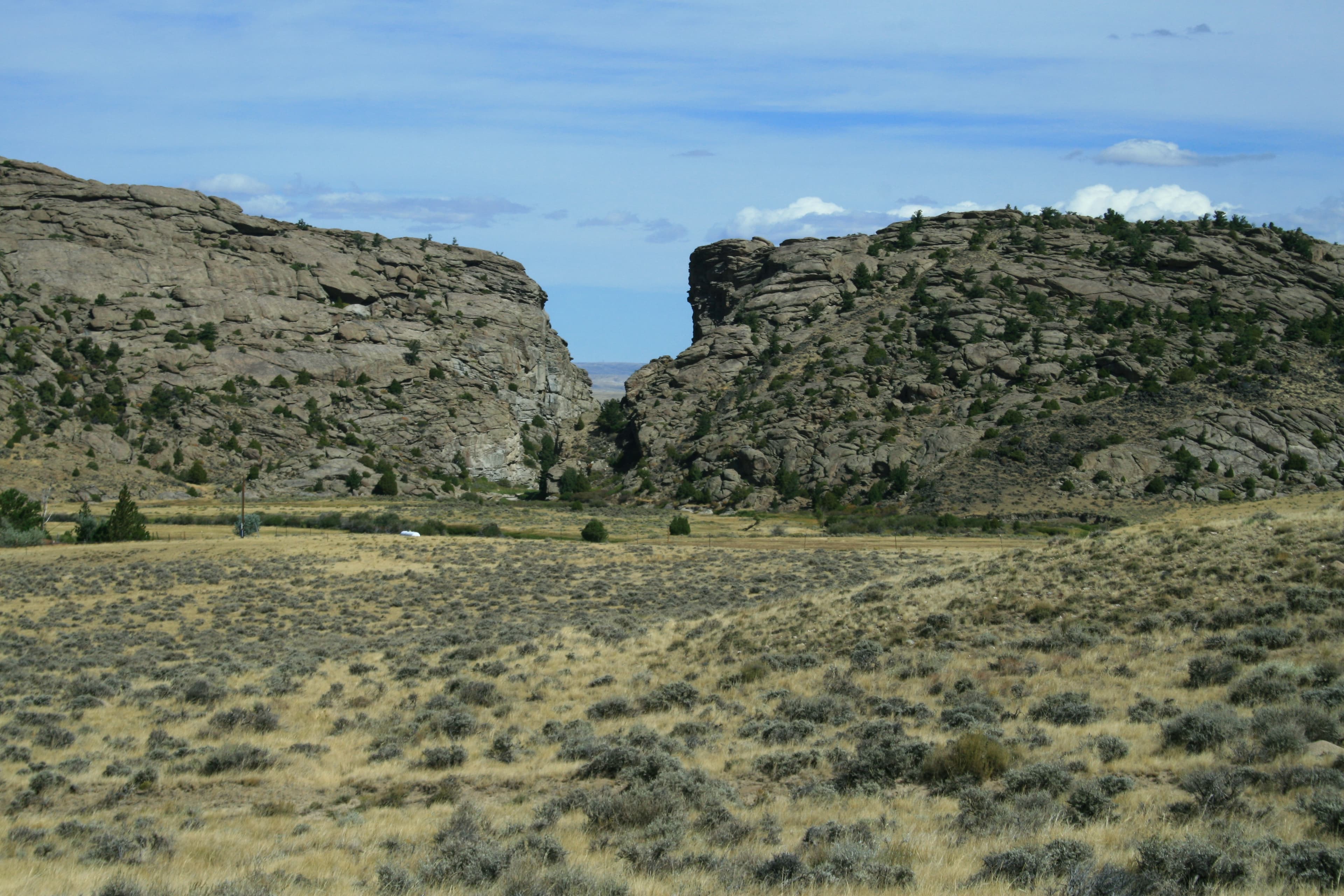
Rideable terrain here is noted as 2,000 miles, giving riders a clearer sense of scale before they ever unload. For equestrians, the Pony Express Trail offers the opportunity to ride through landscapes that closely resemble what the original riders experienced in the 1860s. While the route is not a single continuous horseback trail, several segments—particularly across Utah, Nevada, and parts of Nebraska and Wyoming—allow riders to explore historic travel corridors on horseback.
Rideable terrain
2,000 miles
Trailer parking
Simpson Springs Staging Area Location: West Desert region of Utah along the Pony Express Backcountry Byway. Why riders use it Large open staging area suitable for horse trailers Direct access to long segments of the historic Pony Express route One of the most commonly used starting points for horseback exploration along the trail corridor BLM campground nearby with space for overnight stays. Camp Floyd / Fairfield Staging Area Location: Fairfield area southwest of Salt Lake City near Camp Floyd State Park. Why riders use it Trailer parking available near historic Pony Express station sites Access to desert riding routes that follow portions of the historic trail corridor Good staging location before entering the remote west desert sections. Fish Springs / Sand Mountain Staging Area Location: Western Utah near the Utah–Nevada border along the Pony Express Backcountry Byway. Why riders use it Large areas of BLM land allow dispersed trailer parking Access to some of the longest uninterrupted sections of the Pony Express route Wide open desert terrain suitable for long-distance riding. Rock Creek Station State Historical Park Location: Southeastern Nebraska near Fairbury. Why riders use it Parking areas capable of accommodating horse trailers Access to prairie riding terrain and preserved historic Pony Express station grounds Well-maintained historic site with interpretive exhibits. Ash Hollow State Historical Park Location: Western Nebraska near Lewellen. Why riders use it Parking areas suitable for trailers near the historic site Access to preserved wagon ruts and historic trail segments Scenic prairie and bluff terrain along the historic trail corridor. Ibapah / Deep Creek Area Staging Location: Western Utah near the Nevada border along the Pony Express Backcountry Byway. Why riders use it Remote staging areas with space for trailers Access to long historic trail segments across high desert terrain Minimal traffic and expansive open landscapes suitable for endurance-style riding.
Horse regulations
Horseback riding along the Pony Express National Historic Trail is permitted on portions of the historic route where the corridor crosses public lands that allow equestrian travel. The Pony Express route is not a continuous managed trail, but rather a historic corridor that passes through a mix of federal, state, and private lands. Because of this, horseback access and regulations vary depending on the land manager responsible for each segment. Riders should review local land management guidelines before visiting, as some sections of the historic route are not open to public travel. However, several core regulations and best practices apply for riders traveling along the trail corridor. Riding Is Only Allowed Where Public Access Exists Horseback riding is generally permitted where the historic route crosses lands managed by agencies such as the Bureau of Land Management or U.S. Forest Service. Some sections of the Pony Express Trail pass through private property or protected historic sites where horseback access may not be allowed. Riders must obtain permission before crossing private land and follow posted signage indicating access restrictions. Travel on Existing Roads and Routes Because the Pony Express Trail is primarily a historic route rather than a maintained trail system, riders should remain on established roads, historic corridors, or designated trails where travel is permitted. Riding off established routes in ways that damage historic wagon ruts, archaeological features, or fragile desert soils is prohibited. Historic Resource Protection Many locations along the trail contain preserved station ruins, wagon ruts, and archaeological artifacts. Collecting artifacts, digging, or disturbing historic features is not allowed. Riders should avoid riding directly on visible wagon ruts or historic structures to help preserve these fragile cultural resources. Feed and Invasive Species Control To help protect native ecosystems along the trail corridor, riders are encouraged to: Bring certified weed-free hay or feed Clean trailers, hooves, and tack before entering riding areas These practices help prevent the spread of invasive plants across fragile prairie and desert environments. Stock Control and Backcountry Responsibility Riders traveling along the Pony Express corridor should: Maintain control of horses at all times Ride responsibly on open desert roads and historic routes Yield to other trail users and motor vehicles where routes overlap with backcountry roads Avoid damaging vegetation or historic resources Remote Conditions and Self-Sufficiency Many rideable segments of the Pony Express Trail cross extremely remote landscapes, particularly in Utah and Nevada. Riders should plan to be largely self-sufficient and bring adequate water, feed, and equipment for both horses and riders when exploring these areas. Cell service, shade, and water sources may be limited or unavailable in much of the trail corridor.
Getting here
Use 914 Penn Street, St Joseph, Missouri as your primary planning reference before you haul in. Simpson Springs Staging Area Location: West Desert region of Utah along the Pony Express Backcountry Byway. Why riders use it Large open staging area suitable for horse trailers Direct access to long segments of the historic Pony Express route One of the most commonly used starting points for horseback exploration along the trail corridor BLM campground nearby with space for overnight stays. Camp Floyd / Fairfield Staging Area Location: Fairfield area southwest of Salt Lake City near Camp Floyd State Park. Why riders use it Trailer parking available near historic Pony Express station sites Access to desert riding routes that follow portions of the historic trail corridor Good staging location before entering the remote west desert sections. Fish Springs / Sand Mountain Staging Area Location: Western Utah near the Utah–Nevada border along the Pony Express Backcountry Byway. Why riders use it Large areas of BLM land allow dispersed trailer parking Access to some of the longest uninterrupted sections of the Pony Express route Wide open desert terrain suitable for long-distance riding. Rock Creek Station State Historical Park Location: Southeastern Nebraska near Fairbury. Why riders use it Parking areas capable of accommodating horse trailers Access to prairie riding terrain and preserved historic Pony Express station grounds Well-maintained historic site with interpretive exhibits. Ash Hollow State Historical Park Location: Western Nebraska near Lewellen. Why riders use it Parking areas suitable for trailers near the historic site Access to preserved wagon ruts and historic trail segments Scenic prairie and bluff terrain along the historic trail corridor. Ibapah / Deep Creek Area Staging Location: Western Utah near the Nevada border along the Pony Express Backcountry Byway. Why riders use it Remote staging areas with space for trailers Access to long historic trail segments across high desert terrain Minimal traffic and expansive open landscapes suitable for endurance-style riding.
Planning your visit
Riding along the Pony Express National Historic Trail is very different from riding in a typical national park or managed trail system. The Pony Express route is a historic corridor rather than a continuous maintained trail, and horseback access varies widely depending on land ownership and terrain. The Trail Is Not a Continuous Riding Route The Pony Express National Historic Trail stretches roughly 2,000 Miles across eight states, but it is not a single uninterrupted horseback trail. The route crosses a mix of public lands, private property, highways, and historic sites. Riders typically explore the trail in segments rather than attempting long uninterrupted journeys. Public Land Access Varies Large rideable sections of the trail exist on Bureau of Land Management and other public lands, especially in Utah and Nevada. However, some portions of the historic route pass through private property where horseback access is not allowed without permission. Riders should confirm access and follow posted signage before traveling any segment. Expect Remote and Primitive Conditions Many of the most authentic riding areas along the Pony Express Trail cross remote desert basins, prairie landscapes, and backcountry roads. Facilities are extremely limited and riders should expect little to no water, shade, or services in many locations. Plan to Be Self-Sufficient Equestrians traveling the Pony Express corridor should bring sufficient water, feed, and emergency supplies for both horses and riders. Trailer services, veterinary assistance, and cell service may be unavailable in many areas along the route. Historic Sites Are Fragile The trail corridor preserves wagon ruts, station ruins, and archaeological sites dating back to the 1800s. Riders should avoid riding directly on historic wagon ruts or disturbing visible artifacts so these resources remain protected for future visitors. Terrain Can Be Harsh for Horses Depending on the region, riders may encounter rocky desert ground, loose sand, sagebrush flats, or exposed prairie. Horses should be conditioned for long distances and riders should plan routes carefully to avoid overexertion in hot or dry environments. The Best Riding Is Often in the Western Segments Some of the longest and most accessible riding opportunities along the Pony Express Trail occur in Utah and Nevada where the historic route crosses large areas of open public land. These regions allow riders to experience expansive landscapes similar to what Pony Express riders traveled in the 1860s.
Where to stay
Pony Express National Museum is the main visitor-contact point tied to this destination, which is helpful when you want current conditions, maps, and stock-use updates before riding. This entry reads best as a bring-your-own-horse destination rather than a horse-rental stop, and amenities should be confirmed directly before travel. For a polished trip plan, pair the ride with lodging, fuel, and resupply planning in or near St Joseph before heading deeper into federal-land access points.
Trails
No trails synced for this park yet.
Campgrounds
No campgrounds listed for this park.
Points of interest
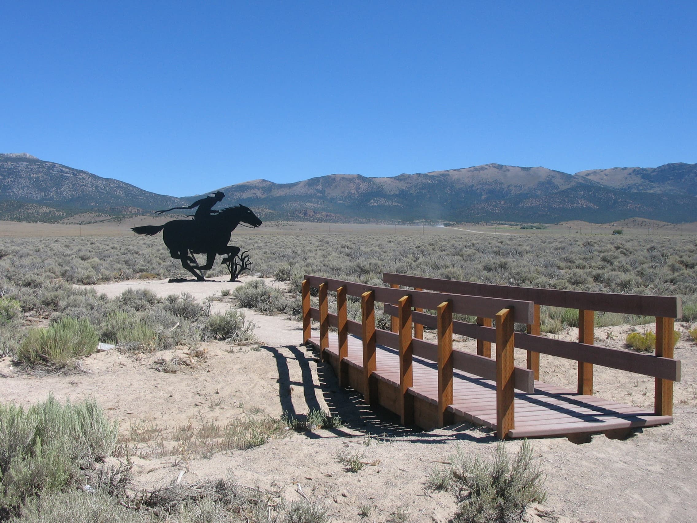
Antelope Spring Station
POIPony Express riders exchanged horses at Antelope Springs Station, about 18 miles west of today’s Utah/Nevada state boundary. Northern Paiute and Goshute Shoshone warriors burned the station during the Pyramid Lake War in June 1860, but it was later rebuilt. Nothing is left of the station today, but brown, T-shaped trail marker along the road indicates its approximate location.
B.F. Hastings Building
POIThe Pony Express route follows J Street, passing through the city of Sacramento, heading directly to the B. F. Hastings Building, which was the western terminus for the Pony Express during most of its existence. Express mail bound for San Francisco usually reached its destination on the ferry Antelope. Old Sacramento includes two Pony Express historic sites-the B.F. Hastings Building and a Pony Express statue.
Big Sandy Station
POIWith both the Big Sandy and Little Sandy creeks flowing nearby, and the crossing for the Big Sandy Creek being just a short distance north, Big Sandy station had a great location. It served as both a stage station and a Pony Express relay station until 1862.
Boyd Station
POIBoyd Station, built around 1855, is the best-preserved Pony Express station in Utah. Visitors can walk among the ruins and imagine what life was like at this remote desert site. Traces of the original trail are clear on the ground there and on satellite imagery, heading northwest toward the next station at Willow Springs (present-day Callao).
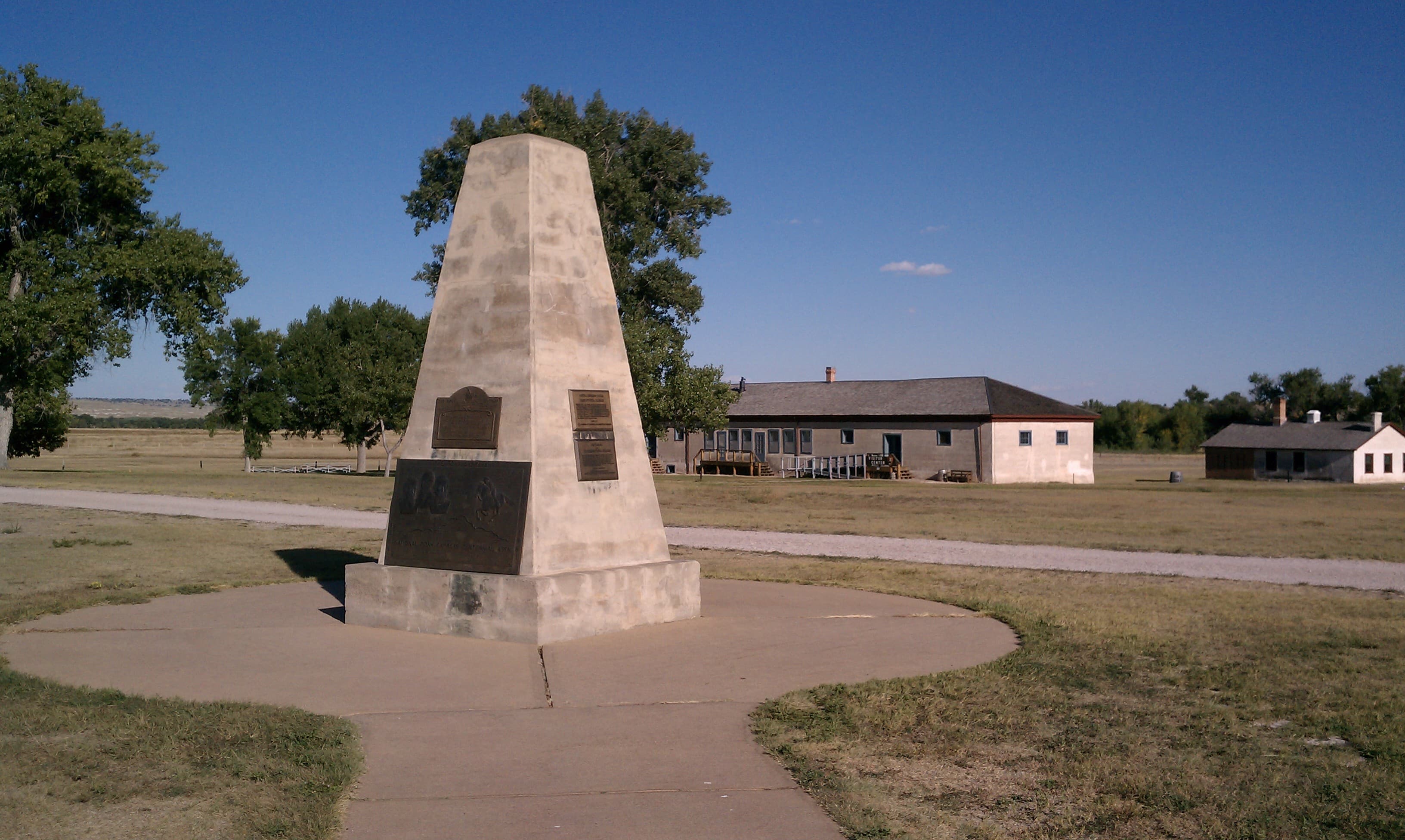
Camp Floyd State Park
POIAt the time of the Pony Express, Camp Floyd provided troops for protection against Indian attacks and served to keep the trail open for the Pony Express, stage lines, and other travelers. The Pony Express Station was a small adobe building that stood several hundred feet northeast of John Carson's Inn. Though the Pony Express station has long since disappeared, the Inn still stands as the centerpiece of today's state park. The Inn has been restored and is open for visitation.
Canyon Station
POIBuilt in the shadowy depths of Overland Canyon, Utah, Canyon Station served the Pony Express (1861) and the Overland Stage (1861-1863). In August 1863, Goshute Indians wiped out the stage station and its personnel. A monument, visible from the nearby road, stands near the site, later known as Burnt Station. To visit, follow Pony Express Rd north from Willow Springs Station for about 16 miles into the Deep Creek Mountains. The monument is on the west side of a dry wash.
Carson Station
POIA granite monument with historical information stands on the sidewalk in front of a diner at the southwest corner of 3rd and Carson streets in Carson City, Nevada. Street parking is available.
Cold Springs Pony Express Station
POICold Springs Station was a home station for the Pony Express. Home stations were larger buildings that housed riders and provided fresh horses. Station keepers and several stock tenders were assigned to home stations. They led an isolated and dangerous life. The intact, standing ruins of Cold Springs Station provides a glimpse into their lives and the Pony Express riders that depended on them.
Deep Creek Station
POIHoward Egan’s ranch served as a station for the Pony Express, Overland Stage, and transcontinental telegraph at present Ibapah (formerly Deep Creek), an unincorporated community in western Utah. Learn about area and its history at an interpretive monument near the community school and see a 1934 Pony Express monument south of the community. The original home station site is on private land about a mile north of the community.
Diamond Springs Station
POIA stone and concrete monument marks the approximate location of Diamond Springs Pony Express and Overland Stage & Mail Station, about 27 miles north of Eureka, Nev., just south of the intersection of Eureka-Thompsons and Telegraph Canyon Rds. The monument includes a Pony Express centennial medallion and a more recent plaque telling of Pony rider George Scovell and his horse, What?.
Dugway Station
POIDugway Pony Express Station was a lonely dugout – a hole in the ground covered with a roof. Three attempts to dig a well there failed, so the station manager and rider had to haul water from Fish Springs. Today a stone monument, built by the Civilian Conservation Corps in the 1930s, commemorates the site and a silver fencepost marks the station’s former location. This site is a 1.7-mile drive off the maintained road, Simpson Springs-Callao Rd.
Egan Canyon Station
POIAt Egan Canyon, warriors repeatedly clashed with Pony Express men and soldiers during the 1860 Pyramid Lake War. To visit the canyon, turn west from US-93 at Shelbourne onto White Pine County Rd 21/ NV-489. In about 8 miles, turn left at Cherry Creek onto County Rd 23, which becomes Egan Canyon Rd. Continue 4.6 miles to the canyon head, where the road forks. The station site lay ahead on what is now private land. Bear right and continue ½ mile to Fort Pearce Cemetery.
Faust's Pony Express Station
POIGeorge Chorpenning erected the station in 1858. Henry J. "Doc" Faust later purchased the land as a ranch and raised horses for the Pony Express and later military operations. Faust served as station keeper during the Pony Express era and lived on the land until 1870, when he moved to Salt Lake City and went into the livery business. As late as 1978, the stone station house and a cemetery still existed on private land. A misplaced marker also stands north of the site.
Fish Springs
POIFish Springs, today a national wildlife refuge, looks much the same as it did during the days of the Pony Express and Overland Stage. The station site, with no standing ruins, is marked with a silver-colored steel fencepost, and a stone monument built by the Civilian Conservation Corps stands along the west side of Pony Express Road, less than a mile northwest of the refuge entrance.
Gothenburg Pony Express Station
POIGothenburg is home to two original Pony Express stations. The Sam Machette station (museum) is located in the beautiful Ehmen city park/arboretum. The original log building was disassembled, moved and reassembled in its current location in 1931 after it was donated to the city of Gothenburg by Mrs. C.A. Williams. The second station (Midway Station) in Gothenburg is still located on the original Oregon/Pony Express trail just south of town on private property.
Grubbs Well
POINothing remains of Grubb’s Well, also called Camp Station—a simple, teepee-like structure built of poles covered by rushes and grass, much like an American Indian wikiup. Researchers believe it was built in 1861 to serve the Overland Stage & Mail, but it was shared for five months (July-November) with the Pony Express. A T-shaped trail marker stands alongside Pony Express Trail Rd at the approximate site location, about 18 miles northwest of Eureka, Nevada.
Guittard Pony Express Station
POIIn 1859 George Guittard built a 12-room, two story lodge to accommodate the needs of more and more people passing through by wagon, coach, and horseback. Guittard Station served as an inn to refresh travelers, sell supplies and water, graze and shelter animals, and aid in repairing wagons and coaches. This location became a relay station for the famous Pony Express in 1860 as part of its mail dispatch between Missouri and California.
Marysville Pony Express Barn
POIIn 1859, Joseph H. Cottrell and Hank Williams built a stone barn in Marysville, Kansas. In 1860, they contracted with Russell, Majors, & Waddell to lease the barn as a livery stable for the Pony Express. The north end of the structure served as a blacksmith shop and stalls were on the other side. This stable now serves as a museum. The Pony Express station was located in the Barrett Hotel, on the corner of Eighth Street and Broadway about one block north of the stable.
Murray City Park & Traders Rest Station
POIAfter it stopped at the Salt Lake House, the Pony Express traversed through Murray City Park on its way to the first station south of Salt Lake City, Traders Rest/Traveler's Rest. Entering the park from State Street, the trail traveled near the Chief Wasatch statue. Travel less than 3 miles south on State Street to the location of the Traders Rest station and imagine how things have changed since 1861.
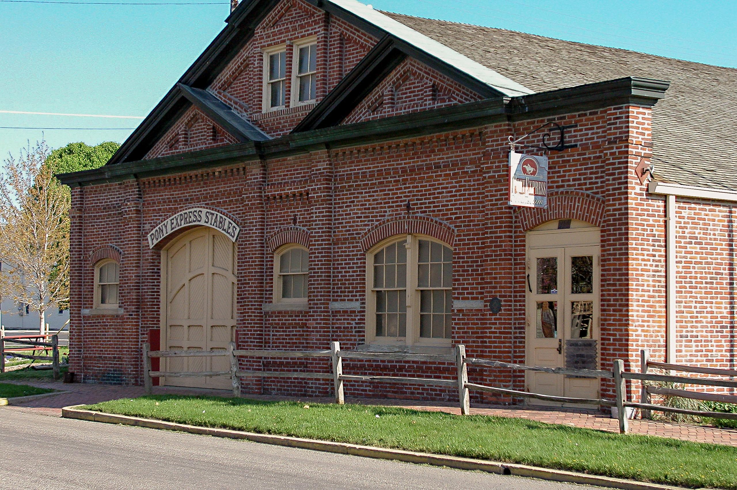
Pikes Peak Stables, Pony Express National Museum
POIOn April 3, William (Billie) Richardson left this stable, rode the short distance to the Patee House, picked up the waiting mochila, and headed west on the first Pony Express run to Sacramento, California, nearly 2,000 miles away. The original wooden structure was replaced by a brick building in 1888, but some of the original posts and beams were reused. In 1950, the Goetz Foundation restored the building to its 1888 brick appearance and established a museum.
Point Lookout Station
POIPoint Lookout Pony Express and stage station stood on a flat below Lookout Pass, in Utah’s Onaqui Mountains. It is reached by maintained, unpaved Pony Express Rd. A stone Pony Express monument is on the right side of the road, 0.7 mile on the west side of the pass. A silver post that marks the station site stands 30 yards northeast of the monument. Remains of a later settler’s pet cemetery are on the opposite side of the road.
Pony Express Monument
POIA monument erected by the Pony Express Centennial Association. The monument celebrates the riders and owners of the famous mail delivery system.
Pony Express Museum, Seneca Pony Express Station
POIThe first Pony Express home station west of St. Joesph, Missouri, was the Smith Hotel in Seneca, Kansas. The Pony Express Museum, located across the street from the hotel, interprets the story of the trail with many artifacts from the original hotel, on loan from the Smith family. There is a Pony Express marker located nearby. The original route of the Pony Express travels through Seneca, roughly on Main Street.
Pony Express National Historic Trail
POIIt is hard to believe that young men once rode horses to carry mail from Missouri to California in the unprecedented time of only 10 days. This relay system along the Pony Express National Historic Trail in eight states was the most direct and practical means of east-west communications before the telegraph. The trail traverses 8 states: CA, UT, CO, NV, WY, NE, KS, & MO. It is administered by the National Trails Office Regions 6|7|8 in Santa Fe, New Mexico.
Pony Express Station Monument, Salt Lake City
POIA curbside monument in front of the First National Bank Building at 163 South Main Street commemorates the Great Salt Lake City Pony Express Station. A plaque, located near the entrance of the Tribune Building a few doors north of the monument, lists Utah Pony Express riders and superintendents. The Tribune Building stands at the former site of Salt Lake House, a historic hotel where many notable travelers, including Mark Twain, stayed while visiting Salt Lake City.
Roberts Creek Station
POIThe Roberts Creek Station site is located within a privately owned, working ranch- yard, not accessible to the public, about 18 miles northwest of Eureka, Nevada. Nothing remains of the log station, and the site and station marker are not visible from public right of way. The access road to the site is gated.
Sand Springs Station
POISand Springs Station was a Pony Express relay station, a place where riders could exchange their tired horses for fresh ones. As they only housed 1-2 employees, relay stations were much smaller that home stations, which housed 5-6 employees and the riders. But, something is amiss with Sand Springs Station. Its ruins reveal a building nearly as large as Cold Springs Station, a known home station!
Schell Creek Station
POIVisitors to the interpretive turnout on US-93 at Schellbourne, Nevada, can follow a short path to a larger-than-life silhouette cutout of a Pony Express rider. Wayside exhibits along the path share information about Pony Express history, horses, and riders, and a nearby kiosk offers more information. The historic site of Schell Creek Pony Express, which is not open to visitors, lies about 3 miles east of this location.
Simpson Springs Pony Express Station
POIThe availability of excellent water made Simpson Springs one of the most prominent stations in the West Desert. George Chorpenning established his second mail station at this site in 1858, which was later used by the Pony Express and the Overland Stage. A number of structures have been built and destroyed in the vicinity of Simpson Springs over the years. The current building is a replica, built in 1975 by the Future Farmers of America under the direction of the BLM.
South Platte Station, Big Springs, Nebraska
POIVisit Big Springs, Nebraska to learn more about the Pony Express and the South Platte Station's history. Joseph Slade was the division superintendent for the division of the Pony Express that went from Fort Kearny to Horseshoe Creek station. His reputation as a "mean and sadistic bully" was strengthened by his feud with and killing of the Julesburg station keeper, Jules Reni. Slade was hanged on March 9, 1864 for the crime.
Spring Valley Station
POIA marker post near the intersection of Whiskey Rd and White Pine County Rd 31, in White Pine County, Nevada, approximates the location of Spring Valley Pony Express Station. Rider Nick Wilson later recounted being struck by an arrow here during the 1860 Pyramid Lake War. Although the station site lies on private ranchland, it can be viewed from the public road. A nearby historic stone is not known to have any association with the 1860-1861 Pony Express operation.
Willow Springs Station
POI
Things to do
Become a Pony Express Trail Junior Ranger
Learn about the Pony Express Trail and earn your junior ranger badge! This activity can be completed virtually or after visiting a site along the Pony Express National Historic Trail. Booklets can be submitted either electronically or by mail. Take a look and start exploring the trail today!
Check out Museums and Visitor Centers along the Pony Express Trail
There are a number of museums and visitor centers along the Pony Express Trail. In some places, you may find more interpretive exhibits, information, and programs. In other places, being in the location will enrich your experience, even with minimal facilities. Visit one of these locations to learn more about the history and culture of the Trail.
Horseback Riding on the Pony Express Trail
Take a ride back in time on the Pony Express Trail! The variety of opportunities ranges from historic landscapes to modern views, and from short to longer trail rides. Riding the Trail is a great way to connect to this fascinating story of transportation, tenacity and technology. Saddle up and imagine the riders traveling these trails, over 1,800 miles total, in ten days!
Walk on the Pony Express Trail
There are a variety of walking and hiking opportunities along the Pony Express Trail. In some places, you may find a modern-day hiking trail. In other places, the historic trail has been replaced by an dirt or asphalt road. The variety of opportunities will give you a chance to walk in the path of the pony riders and bring you closer to the historical landscape.
Hours of operation
Pony Express National Historic Trail
The Pony Express National Historic Trail is not a clearly marked hiking trail. Instead it is a route that passes through communities, urban areas, public lands, and Wilderness. The route travels across a variety of land ownerships and management, including private land. Each location varies as to the hours of operations and access. Please contact individual trail sites before your visit for more information.
Mon
All Day
Tue
All Day
Wed
All Day
Thu
All Day
Fri
All Day
Sat
All Day
Sun
All Day
Activities
Weather
Due to the length of the Pony Express National Historic Trail, be sure to consult local weather sources for the region you'll be visiting. Check out the forecast with the National Weather Service and search for the area you'd like to visit: weather.gov
Contact
Photos
Stay near this park
No horse-friendly stays listed near Pony Express National Historic Trail yet. Know a great barn or property? Help fellow riders by listing it.
List your propertyDirections
You can visit many sites of the Pony Express National Historic Trail over the 1,800-mile historic route that crosses 8 states.
Source: nps.gov