
Park Closure
Areas of Meridian Hill Park closed for repairs
Much of the upper level of the park is closed to rehabilitate the grass. Fountains and the reflecting pool are open but may be turned off or drained occasionally for maintenance. The reflecting pool will undergo repairs June 20-28. Visit the Meridian Hill Park page for more information.
More infoPark Closure
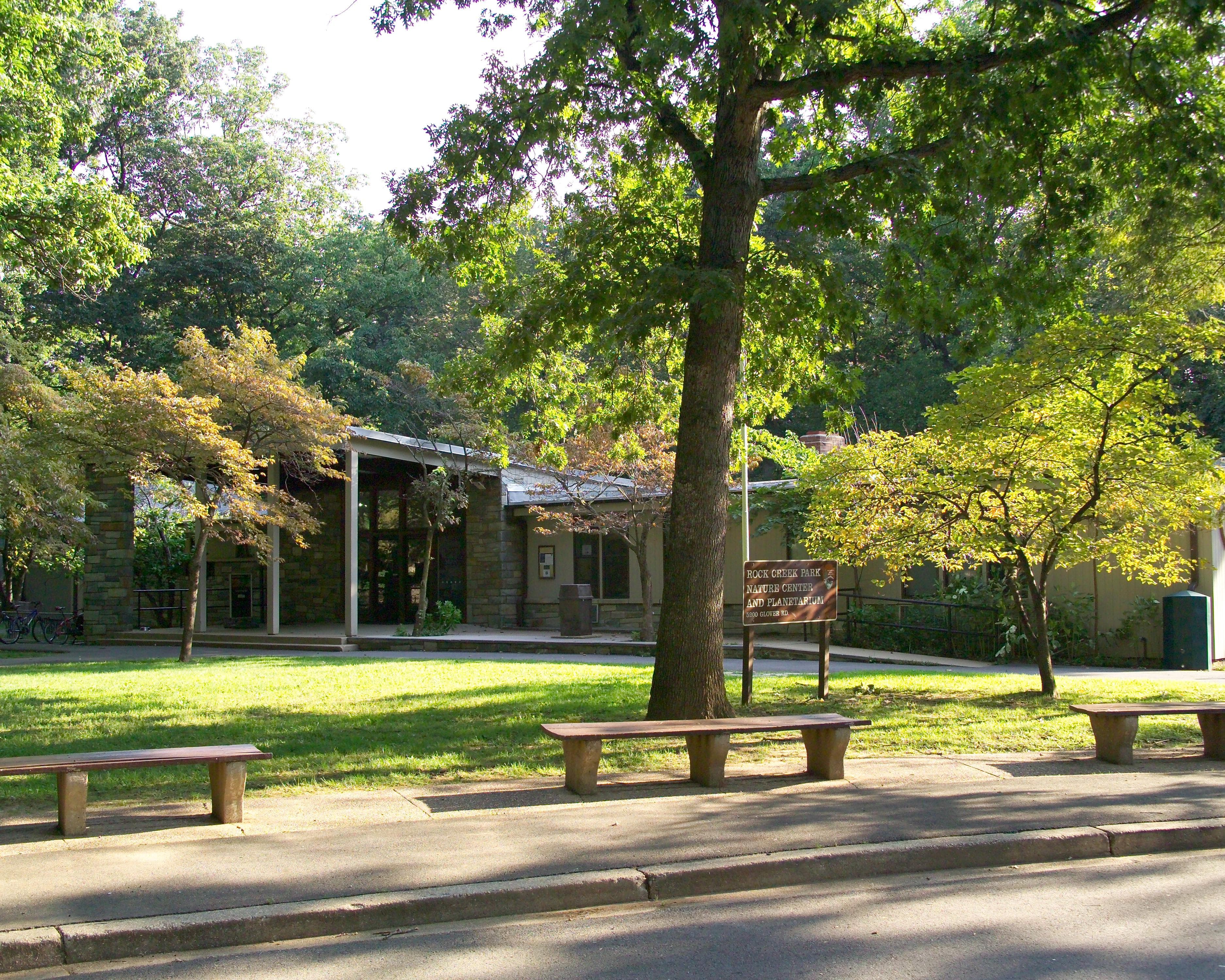
Nature Center and Planetarium Closure
The Nature Center and Planetarium building is closed until further notice due to continued remediation. Check the park's calendar for changes to ranger programs and locations.
Danger
Glover Archbold Trail detour
For visitor safety, the southern end of the Glover Archbold Trail is under an emergency closure until further notice due to aerial hazards. Please follow the posted detour along Foxhall Rd. / 44th St. NW / P St. NW.
More infoPark Closure
Part of Fort Totten Park remains closed for public safety
Out of an abundance of caution, Fort Totten Park will remain closed east of Fort Totten Drive, south of Gallatin Street/Metropolitan Branch Trail and north of Brookland Ave NE/Farragut St. due to the investigation involving two WWI-era munitions found.
More infoRock Creek Park
DC · NW, Washington
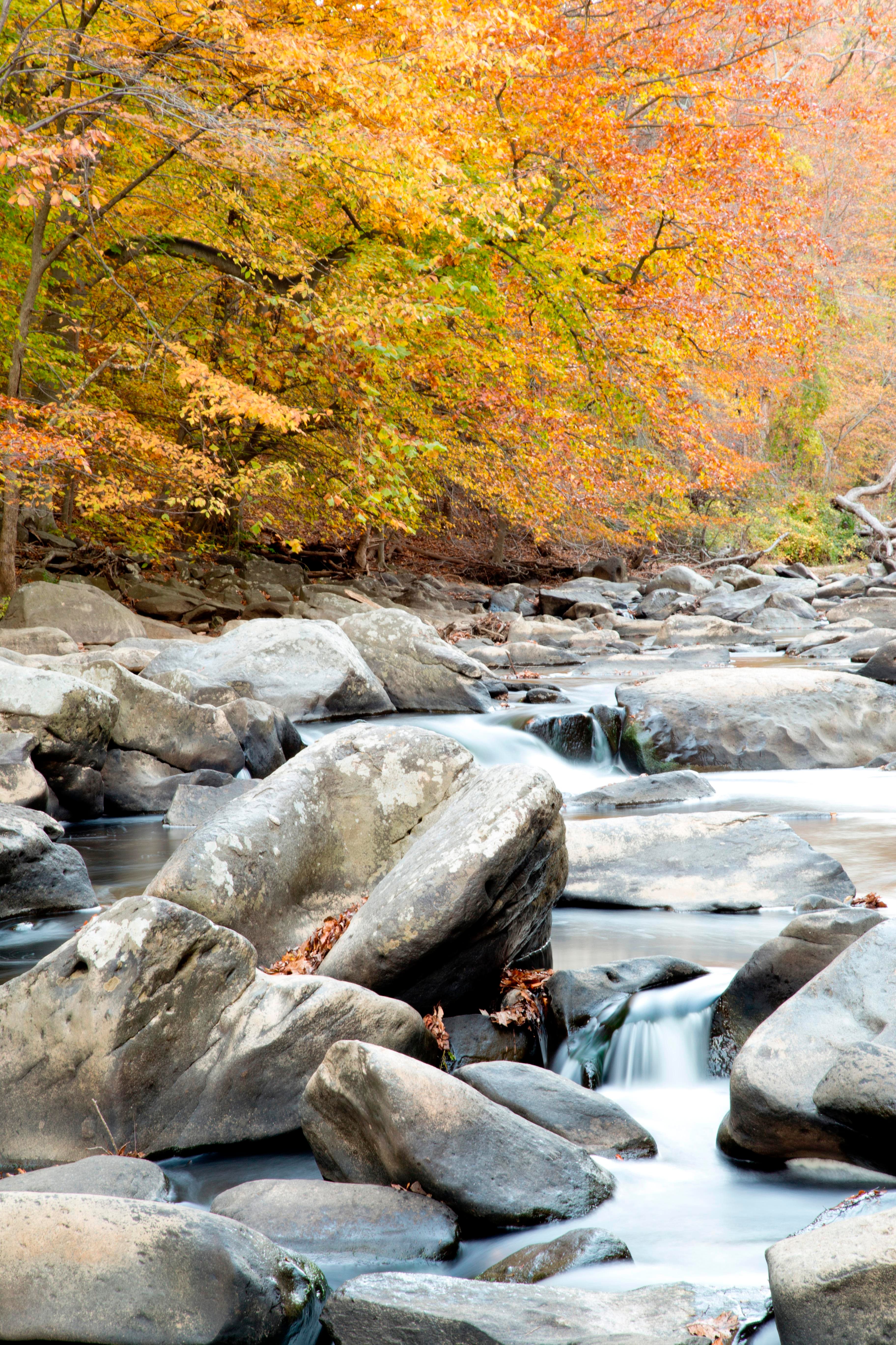
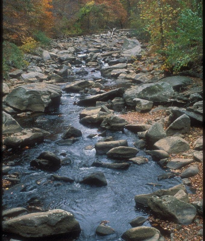
Rock Creek Park is truly a gem in our nation's capital. This 1,754 acre city park was officially authorized in 1890, making it the third national park to be designated by the federal government. It offers visitors the opportunity to escape the bustle of the city and find a peaceful refuge, recreation, fresh air, majestic trees, wild animals, and thousands of years of human history.
Riding guide
Horses provided
Highlights
Rock Creek Park offers one of the most unique horseback riding experiences in the National Park system.
Riding
Rideable terrain here is noted as 13 miles, giving riders a clearer sense of scale before they ever unload. The park’s 13 Miles of dedicated bridle trails wind through a quiet wooded valley carved by Rock Creek, creating a surprising sense of wilderness within the city. Riders travel beneath towering oak, beech, and tulip poplar trees while following dirt and gravel paths that weave along the creek and through rolling forest hills.
Rideable terrain
13 miles
Trailer parking
Rock Creek Park Horse Center (Primary Staging Area) Why riders use it Main equestrian facility in the park Direct access to the park’s ~13 Miles of bridle trails Includes barns, riding rings, and horse facilities. Parking details A small parking area is available at the Horse Center, with additional parking nearby at the Nature Center. This is the most reliable place to stage horses in the park. Important note Space for large trailers is limited due to the park’s urban layout. Rock Creek Park Nature Center Parking Area Location Near the Horse Center along Glover Road NW. Why riders use it Additional overflow parking when the Horse Center lot fills Close access to the same bridle trail network. This lot is sometimes used by riders hauling smaller trailers. Military Road / Boundary Pullouts (Limited Use) Some riders occasionally stage from wider roadside pullouts along park roads near trail access points. Important considerations Parking must not block traffic or park access roads These spots are not formal equestrian staging areas.
Horse regulations
Key rules: Horses must remain on designated bridle paths. Riding on paved trails, pedestrian paths, and roadways is prohibited unless crossing them at approved locations. Riding off-trail is not allowed. Authorized Stock Animals Horses Mules Other livestock or pack animals are not typically allowed within the park’s bridle system. Trail Etiquette and Shared Use The bridle trails are often near hiking routes and other visitor areas. Riders should: Maintain control of their horses at all times Slow to a walk when approaching or passing pedestrians Announce themselves when approaching from behind Yield appropriately where trails intersect with pedestrian routes Riding Behavior Rules To protect trails and other visitors: Galloping or fast riding is prohibited on park trails. Horses may only be ridden at safe speeds appropriate for shared trail environments. Horse Handling and Care To protect vegetation and park facilities: Horses should not be tied to trees or vegetation. Hitching should occur only at designated rails or appropriate locations. Riders should manage manure responsibly near staging areas. Access Through the Horse Center Most equestrian activity begins at the Rock Creek Park Horse Center, which provides: Trail access Riding lessons Boarding and horse care services Visitors bringing their own horses should check with the facility or park staff for current access guidance.
Getting here
Use 3545 Williamsburg Ln, NW, Washington, District of Columbia as your primary planning reference before you haul in. Rock Creek Park Horse Center (Primary Staging Area) Why riders use it Main equestrian facility in the park Direct access to the park’s ~13 Miles of bridle trails Includes barns, riding rings, and horse facilities. Parking details A small parking area is available at the Horse Center, with additional parking nearby at the Nature Center. This is the most reliable place to stage horses in the park. Important note Space for large trailers is limited due to the park’s urban layout. Rock Creek Park Nature Center Parking Area Location Near the Horse Center along Glover Road NW. Why riders use it Additional overflow parking when the Horse Center lot fills Close access to the same bridle trail network. This lot is sometimes used by riders hauling smaller trailers. Military Road / Boundary Pullouts (Limited Use) Some riders occasionally stage from wider roadside pullouts along park roads near trail access points. Important considerations Parking must not block traffic or park access roads These spots are not formal equestrian staging areas.
Planning your visit
Most Riding Begins at the Rock Creek Park Horse Center The Rock Creek Park Horse Center is the primary access point for riders bringing their own horses. The facility provides: Access to the park’s bridle trail system Boarding and riding facilities The most reliable staging location for horses in the park Trailer space is limited, so arriving early is recommended. The Trail System Is Relatively Small The park contains about 13 Miles of designated bridle trails. These trails are best suited for: Shorter rides Beginner or intermediate riders Relaxed forest trail riding Many riders combine several loops to extend their ride. Expect Shared Trail Areas Although bridle trails are separate from most hiking routes, the park is heavily used by visitors. Riders may encounter: Hikers Runners Cyclists near trail crossings Maintaining control of horses and slowing when passing others is essential. Urban Setting Means Nearby Traffic and Noise Even though the park feels wooded and quiet, it sits within a dense urban area. Horses may encounter: Nearby traffic sounds Sirens or city noise Bridges and road crossings Horses unfamiliar with urban environments may need extra care. Trails Can Become Muddy After Rain Rock Creek Park’s wooded valley soils can become soft after heavy rain. Riders should: Check trail conditions before visiting Avoid riding immediately after storms when possible Ride carefully to prevent trail damage. Wildlife Is Still Present Despite its urban location, the park supports several wildlife species. Common sightings include: White-tailed deer Foxes Hawks and owls Animals are usually accustomed to park visitors but should still be given space.
Where to stay
Peirce-Klingle Mansion- Rock Creek Park Headquarters is the main visitor-contact point tied to this destination, which is helpful when you want current conditions, maps, and stock-use updates before riding. Guided or concession-based riding support is noted here, so riders who are not hauling their own horses may still find an access path into the experience. For a polished trip plan, pair the ride with lodging, fuel, and resupply planning in or near NW, Washington before heading deeper into federal-land access points.
Park map
Trails
No trails synced for this park yet.
Campgrounds
No campgrounds listed for this park.
Points of interest
African American cemetery
POIBlagden Mill
POIBeginning in the late 1700s, the Blagden Mill turned wheat into flour. By the 1890s, it was out of commission and falling down. The structure was finally torn down to make way for Beach Drive about 1897.
Bluff Bridge
POIOne of the bridges that crosses Rock Creek.
Boulder Bridge
POIThe view of Boulder Bridge from the stream bank is an iconic view of Rock Creek.
Boundary Bridge
POIBoundary Bridge is the northernmost bridge in Rock Creek Park and spans the creek at the DC/Maryland border.
Bryce Park
POIBryce Park is an urban triangle park located in the Cathedral Heights neighborhood of Washington, DC. The park is located to the southwest of the Washington National Cathedral. The area is generally busy, with frequent heavy traffic.
Carter Barron Box Office
POIConduit Road School
POIDam at Peirce Mill
POIThe dam at Peirce Mill was constructed in 1900 and was meant to provide a beautiful view and soundscape for visitors to the renovated Peirce Mill Tea House.
Dante Memorial Statue
POIDante Aligheri was an Italian poet best known for his 1320 work, "The Divine Comedy," an allegorical representation of the afterlife according to the Catholic faith. The statue was a gift from Carlo Barsotti of New York on behalf of Italian-born Americans.
DC Front Runners Memorial Grove
POIThis grove of trees in Rock Creek Park was planted and is cared for by the DC Front Runners, a local LGB running and walking club. In 1988, they collaborated with the National Park Service to establish this memorial grove along a favorite route in honor of members who lost their lives during the AIDS epidemic.
Devils Chair Bridge
POIDumbarton Oaks Park
POIThis 27-acre park in the historic Georgetown neighborhood of Washington, DC, was part of the Dumbarton Oaks estate. Designed by Beatrix Farrand for Mildred and Robert Bliss, the National Park Service now manages the wild portion of the garden while Harvard University manages the formal gardens.
First Baptist Church of Georgetown
POIFirst Baptist Church of Georgetown was largely constructed by members of its congregation at night, after they had finished laboring elsewhere in Georgetown.
Fort Bayard Playground
POIFort Bayard Park playground is located near River Rd. NW and is a fenced in piece of playground equipment.
Fort Reno Park: highest point in District of Columbia
POI<br />Inscriptions<br />National Park Service<br />Highest Natural Elevation<br />In cooperation with the D.C. Association of Land Surveyors<br />Point Reno<br />Elev. 409 Ft.<br />2007<br />Washington D.C.<br />
Francis Asbury Memorial
POIFrancis Asbury (1745-1816) was a traveling preacher in colonial America, and one of the first two bishops appointed to the Methodist Episcopal Church. In DC, he founded Georgetown's Foundry Church.Sculptor: Augustus LukemanInscriptionsfrontFRANCIS ASBURY1745-1816PIONEERMETHODIST BISHOPIN AMERICAbackTHE PROPHETOF THE LONG ROADSide, eastHIS CONTINUOUS JOURNEYING THROUGH CITIESVILLAGES AND SETTLEMENTS FROM 1771 TO 1816GREATLY PROMOTED PATRIOTISM EDUCATION MORALITYAND RELIGION IN
Francis Field
POIFrancis Field is a buffer park between the bustling city of Washington and the Rock Creek and Potomac Parkway.
Francis Field- Basketball Court
POIThe basketball courts at Francis Field are a first-come, first-served space.
Francis Scott Key Memorial
POIThis small park honors the poet and lawyer Francis Scott Key, who lived near this location from 1805 to 1830. Key became famous for penning the poem that would eventually become the National Anthem of the United States of America.
General Artemas Ward Memorial
POIGeneral Artemas Ward was a military officer in the French and Indian War and the American Revolution. He also had a career in politics and law in Massachusetts.
Georgetown Waterfront Park
POIThe Georgetown Waterfront Park provides a green space for visitor recreation and contemplation. The park curves along 10 acres of the Potomac River extending from the Washington Harbour complex to Key Bridge. The park offers visitors amazing views of Theodore Roosevelt Island, Rosslyn, Virginia and the Kennedy Center for the Performing Arts.
Glover Archbold Park
POIGlover Archbold Park stretches for 2.5 miles between Van Ness Street NW and Canal Road in Washington, DC.
Godey Lime Kilns
POILook across the roadway for the remains of the lime kilns. From 1864 to 1907, this facility was used to heat and break down limestone into lime and plaster for construction. By the early 20th century, the invention of Portland cement made the kiln obsolete. This is an exceptionally difficult place to visit on foot. Crossing the roadway is not recommended.
Herring Hill Phillips School
POIPhilips School was built in 1890 to accomodate the African American population of the eastern side of Georgetown and the Herring Hill neighborhood.
Information Panel: Adams Mill
POIInformation Panel: A Garden Protecting Rock Creek
POIInformation Panel: A Gathering Place for Washingtonians, James Buchanan
POIA Gathering Place for Washingtonians Since Meridian Hill Parked opened in 1936, Washingtonians from the diverse neighborhoods surrounding the park have gathered here for performances, community events, and political protest.When tens of thousands of people flocked to Washington, D.C. in the late 1930s and 40s for federal jobs created by the New Deal and World War II, government agencies created a series of free "Starlight" concerts in the park. From 1941 to 1944, Washingtonia
Information Panel: A Hilltop for Heroes and Horse Thieves
POIThis outdoor exhibit highlights some of the men who made the Meridian Hill area home.
Information Panel: An American Meridian
POIInformation on the American Meridian and the surveying of the city is discussed on this outdoor exhibit.
Information Panel: Art for the People
POIThis outdoor exhibit details some of the sculptures within Meridian Hill Park.
Information Panel: Campus to Army Camps and Back Again
POIThis information panel covers past uses of Meridian Hill Park, including college campuses and Army hospitals.
Information Panel: Creating the City Beautiful
POIThis information panel covers the design elements of Meridian Hill Park.
Information Panel: From Seaport to National Park
POIThis information panel describes the transformation of the waterfront from commercial area to green space.
Information Panel: "Herring Highway"- Boulder Bridge
POIThis information panel is about the natural looking (but man-made) elements in the creek.
Information Panel: "Herring Highway"- Milkhouse Ford East
POIThis information panel is part of the Herring Hill series and is located near Milkhouse Ford.
Information Panel: "Herring Highway"- Milkhouse Ford West
POIThis information panel is part of the Herring Highway series and is located near Milkhouse Ford.
Information Panel: "Herring Highway"- Peirce Mill
POIThis informational sign in the Herring Highway series is about the fish ladder.
Information Panel: "Herring Highway"- Picnic Grove 2 South
POIThis information panel is about the fish ladder that helps fish navigate over/around the Peirce Mill dam.
Information Panel: "Herring Highway"- Picnic Grove 8
POIThis information panel is part of the Herring Hill series and is located near the parking area of Picnic Area #08.
Information Panel: "Herring Highway"-Thompson Boat Center
POIThis information panel in the Herring Highway series is located in Georgetown. Contains information on use of the creek by Native Americans.
Information Panel: "Herring Highway"- Zoo Ford
POIThis information panel in the Herring Highway series discusses the impact fords had on the migrating fish of Rock Creek.
Information Panel: Hi, I'm Rocky the Black Rat Snake
POIInformation Panel: Home for the Summer / Veranear en casa
POIInformation Panel: How High is the River?
POIThis informational panel in Georgetown Waterfront Park explains the stream gauge and educates visitors about the river.
Information Panel: Jean Jules Jusserand Memorial
POIInformation Panel: Machine in a Stone Box
POIInformation Panel: Orchards, Fields, Gardens, Pastures
POIInformation Panel: Parrott Ropewalk
POIIn 1804, rope-maker Richard Parrott purchased his Washington, DC, property and developed his estate. Before long, he added a "Ropewalk" for manufacturing rope, a Federal-style mansion, and gardens and orchards. The property was purchased by the United States Government in 1911 for the creation of a public park. Landscape architects George Burnap and Horace Peaslee prepared designs for the park that integrated features from the former estate's landscape and incorporated new el
Information Panel: Robert Emmet Memorial
POIInformation Panel: Rock Creek Park nature center trail: A Living Cycle
POIInformation Panel: Rock Creek Park nature center trail: Animal Homes
POIInformation Panel: Rock Creek Park nature center trail: Forest Food
POIInformation Panel: Rock Creek Park nature center trail: Giants of the Forest
POIInformation Panel: Rock Creek Park nature center trail: Living on the Edge
POIInformation Panel: Rock Creek Park nature center trail: Meadow's End
POIInformation Panel: Rock Creek Park nature center trail: Preserving a Community
POIInformation Panel: Rock Creek Park nature center trail: Two Types of Trees
POIInformation Panel: Rock Creek Park nature center trail: What Happened Here?
POIInformation Panel: Rock Creek's Mills
POIInformation Panels: Creating Meridian Hill
POIVisionary and Park ChampionMeridian Hill Park might never have been built had it not been for the determination of Mary Foote Henderson (1846-1931). For 22 years, she lobbied Congress for funds to buy the land and build the park. Congress's 1910 vote to authorize construction of Meridian Hill Park is a testimony to her resolve.Henderson's efforts in urban development weren't limited to promoting Meridian Hill Park.
Information Panel: The Chesapeake Bay and Its Rivers Yours to Protect
POIAn information panel about the Chesapeake Bay watershed.
Information Panel: The Color Purple
POIInformation Panel: The Peirce Family Estate
POIInformation Panel: Through the Eyes of a Scientist
POIThis information panel is primarily about Rachel Carson and her involvement in the modern environmentalist movement. The panel also discusses how Glover Archbold Park came to be.
Information Panel: We Got Da Blues
POIJames Buchanan Memorial
POIJames Buchanan (1791-1868) was 15th president of the United States. This memorial is in Meridian Hill Park.
James Cardinal Gibbons Memorial
POIThis park was designed and built in 1918. The statue of James Cardinal Gibbons, archbishop of the Diocese of Baltimore, was erected in 1932.
Jean Jules Jusserand Memorial
POIJules Jusserand was the French ambassador to the United States from 1902 to 1925. Jusserand was an accomplished author and close associate of many of Washington's elite, including President Theodore Roosevelt.
Joan of Arc Statue
POIThe Joan of Arc Statue is the only equestrian statue of a woman in Washington, DC. Joan of Arc was a heroic French figure who claimed to receive religious visions telling her to fight for France and overthrow the English during the Hundred Years' War. Upon her capture and trial at the hands of the English, she was burned at the stake, leading the Catholic church to recognize her as a martyr in 1456. She was beatified in 1909 and canonized in 1920.
Joaquin Miller Cabin
POIThe Joaquin Miller Cabin was relocated from the neighborhood near Meridian Hill Park and reconstructed in Rock Creek Park. Joaquin Miller was a poet and writer from California who briefly lived in the cabin when he lived in Washington, DC in the 1880s.
Kahlil Gibran Memorial
POIGibran was a Lebanese-born poet most famous for his 1923 book "The Prophet," a collection of 26 prose poems. The book grew in popularity through the 1960s counterculture movement. Because of its popularity, Gibran is reported to be the third-best-selling poet in world history, behind Shakespeare and Lao Tsu.
Klingle Trail south
POIKlingle Valley Trail top
POILee Feed and Grain
POIFormer location of Lee Feed and Grain, listed as the oldest African American owned business in the 1940s when it closed due to the industrialization of Georgetown.
Little Forest Park
POILittle Forest Park is located in Northwest Washington, DC near Rock Creek Park. It is bordered by Military Road NW, 28th Street NW, Kanawha Street NW and 30th Street NW.
Marconi Memorial
POIGuglielmo Marconi (1874-1937) was the inventor of the first radio wave communication system. Congress approved legislation for the memorial on April 13, 1938, and President Franklin Roosevelt signed the bill into law the next day. The monument was erected with funds collected by the Marconi Memorial Foundation and was completed on June 30, 1941.
Meridian Hill Park
POIMeridian Hill Park, a few blocks north of the White House, features unique statues, concrete aggregate architecture, and the largest cascading fountains in North America.
Meridian Hill Park Cascades
POIThe 13-basin Cascading Fountain in Meridian Hill Park is one of the longest in North America.
Milkhouse Ford
POIThis historic ford is still visible though no longer used.
Montrose Park
POIMontrose Park is a 16-acre park located on the heights overlooking Georgetown in northwest Washington, DC.
Montrose Park Playground
POIMontrose Park playground is located in Montrose Park off of R Street NW in the Georgetown neighborhood of Washington, DC.
Mount Zion and Female Union Band Cemeteries
POIHistoric African American Cemeteries with interments dating back to 1809
Muhlenberg Park
POIJohn Peter Gabriel Muhlenberg (1746-1907) was a clergyman, soldier, and statesman best known for his involvement in the American Revolution.
Noyes Armillary Sphere
POIThe Noyes Armillary Sphere by Carl Paul Jennewein was installed at the bottom of the Great Cascade in the 1930s. The sphere was vandalized in the 1960s and later disappeared after it had been removed from Meridian Hill Park for repair.
Old Stone House
POIGeorgetown's Old Stone House is the oldest building on its original foundation in the District of Columbia, predating the establishment of the District itself.
Parking at Picnic Grove #2 North
POIParking Area with access to Beach Drive, Western Ridge Trail, Roosevelt Spur Trail and the Rock Creek Hiker/Biker trail.
Peirce Barn
POIPeirce Barn is one of the outbuildings that used to be part of the Peirce farm. Today the barn is used as an educational space.
Peirce Barn Restrooms
POIThe unisex restroom facilities are located behind Peirce Barn.
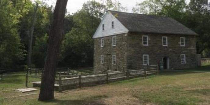
Peirce Mill
POIThe most successful water-powered gristmill along Rock Creek, Peirce Mill ran commercially from the 1820s until 1897. Restored in the 1930s, 1970s, and the first decade of the 21st century, the mill today serves as an educational site connecting visitors to Rock Creek Park's rich heritage.
Peirce Springhouse
POICaution: There is no safe crossing to approach this feature.
Picnic Grove 1
POIPicnic Grove #1 is located near Peirce Mill. It can be reserved from April through November and has a brick pavilion with a fireplace and restrooms attached. Maximum capacity at this site is 75 people.
Picnic Grove 10
POIPicnic Grove 10 has a maximum capacity of 75 people and is one of the many sites in Rock Creek Park that can be reserved from April through November. It has several picnic areas and is the northernmost picnic area in the park.
Picnic Grove #10 Restrooms
POIThe restroom facilities at Picnic Grove #10 are open seasonally as conditions allow. March 2021: These facilities are currently closed.
Picnic Grove 11
POIPicnic Grove 11 is located along Bingham Drive NW which is closed to motor vehicles and is accessible by foot and bicycle only. It is a first-come, first-served picnic area with a maximum capacity of 25 people.
Picnic Grove 12
POIPicnic Grove 12 is located along Bingham Drive NW, which is closed to motor vehicles and is accessible by foot and bicycle only. It is a first-come, first-served picnic area with a maximum capacity of 25 people.
Picnic Grove 13
POIPicnic Grove 13 is one of the sites that can be reserved between May and October. It is close to Military Road NW, the Rock Creek Nature Center, and has a large parking area and pavilion. Maximum capacity at this site is 75 people.
Picnic Grove 14
POIPicnic Grove 14 is located between Glover Road NW and Ridge Road NW, near Picnic Grove 13 and the Rock Creek Park Nature Center and Planetarium. It has a maximum capacity of 25 people.
Picnic Grove 15
POIPicnic Grove 15 is located along Ridge Road NW near where it intersects with Grant Road NW. The picnic area is a first-come, first-served area and is limited to a capacity of 25 people.
Picnic Grove 16
POIPicnic Grove 16 is a small first-come, first-served picnic area with a capacity of 25 people. It is located along Ridge Road NW.
Picnic Grove 17
POIPicnic Grove 17 is a small first-come, first-served picnic area along Ridge Road NW. It has a capacity of 25 people.
Picnic Grove 18
POIPicnic Grove 18 is a small first-come, first-served picnic area located along Ridge Road NW. It has a maximum capacity of 25 people.
Picnic Grove 19
POIPicnic Grove 19 is a first-come, first-served picnic area located near the intersection of Ridge Road NW and Ross Drive NW. It has a maximum capacity of 25 people.
Picnic Grove #1 Restrooms
POIRestroom facilities at Picnic Grove #1 create the rear wall of the picnic pavilion
Picnic Grove 2
POIPicnic Grove 2 is split into north and south sections on opposite sides of the creek. Both sections have sidewalks or multi-use trails that provide safe access to Peirce Mill. Maximum capacity is limited to 25 people per section of the picnic area.
Picnic Grove 20
POIPicnic Grove 20 is located along Ross Drive NW and is a small first-come, first-served picnic area. It has a maximum capacity of 25 people.
Picnic Grove 21
POIPicnic Grove 21 is located along Ross Drive NW and has a small parking area associated with it. It is heavily wooded. This picnic grove has a maximum capacity of 25 people.
Picnic Grove 22
POIPicnic Grove 22 is located on Ross Drive NW and is close to where the bridle trails in the park intersect. It has a maximum capacity of 25 people.
Picnic Grove 23
POIPicnic Grove 23 is a first-come, first-served picnic area tucked between Carter Barron Amphitheater and the Rock Creek Tennis Center near 16th Street NW and Colorado Avenue NW. It has a maximum capacity of 25 people.
Picnic Grove 24
POIPicnic Grove 24 can be reserved from April through November and is located near the Rock Creek Park Tennis Center and Carter Barron Amphitheater. Maximum capacity in this picnic grove is limited to 75 people. There is a playground and restrooms at this location.
Picnic Grove 24 Playground
POIThe playground at Picnic Grove 24 has six swings, two slides, and other elevated features.
Picnic Grove #24 Restrooms
POIRestrooms at Picnic Grove #24 are located near the playground area.
Picnic Grove 25
POIPicnic Grove 25 is located along Ridge Road NW to the north of the Equitation Field. It is a first-come, first-served area with limited parking and a maximum capacity of 25 people.
Picnic Grove 26
POIPicnic Grove 26 is a small first-come, first-served picnic area with a maximum capacity of 25 people. It is located along Ridge Road NW, near the Equitation Field. There is a small, shared parking pull-out and visitors must walk in to the picnic tables.
Picnic Grove 27
POIPicnic Grove 27 is a first-come, first-served picnic area with a maximum capacity of 25 people. It is located along Ridge Road NW and has easy access to the Western Ridge Trail. There is a small parking area associated with this site.
Picnic Grove 28
POIPicnic Grove 28 is situated along Ridge Road NW near the intersection of Broad Branch Road NW. It is a first-come, first-served picnic area with a maximum capacity of 25 people.
Picnic Grove 29
POIPicnic Grove 29 is located near 16th Street NW along the Piney Branch Parkway NW. It has a maximum capacity of 25 people and is a first-come, first-served picnic area.
Picnic Grove 3
POIPicnic Grove 3 is located in a section of Beach Drive NW that is closed to motor vehicles and is accessible by foot or bicycle only. It is a first-come, first-served picnic area with a maximum capacity of 25 people.
Picnic Grove 4
POIPicnic Grove 4 is located in a section of Beach Drive NW near Boulder Bridge that is closed to motor vehicles and is accessible by foot or bicycle only. There are no improvements at this site. It is a first-come, first-served picnic area with a maximum capacity of 25 people.
Picnic Grove 5
POIPicnic Grove 5 is a walk up only picnic area located along Beach Drive NW near the US Park Police substation. It has a maximum capacity of 25 people.
Picnic Grove 6
POIPicnic Grove 6 can be reserved from April through November. It is close to the intersection of Beach Drive NW and Joyce Road NW. This picnic area has a large parking lot, a picnic pavilion, and access to restrooms. Maximum capacity of this site is limited to 75 people.
Picnic Grove #6 restrooms
POIThe restrooms associated with Picnic Grove #6 are on the opposite side of Beach Drive NW from the picnic area near the Joaquin Miller Cabin.
Picnic Grove 7
POIPicnic Grove 7 can be reserved from April through November. The site has few improvements and no pavilion. There is a medium-sized parking area available. Maximum capacity within this site is limited to 75 people.
Picnic Grove 8
POIPicnic Grove 8 is located along Beach Drive NW and has several picnic tables available for use. There is a medium-sized parking area. No other improvements are associated with this site. Maximum capacity is limited to 75 people.
Picnic Grove 9
POIPicnic Grove 9 has access to a medium-sized parking area, several picnic tables, and can be reserved on recreation.gov from April through November.
Poplar Alley
POIP Street Beach and Black Forest
POIIn the latter part of the 20th century, this large grassy “beach” off of Rock Creek and Potomac Parkway was a significant space for the local LGB community. Not only was it a popular LGB gathering place and cruising hotspot, it also was the location of DC’s first unofficial Pride celebration in 1972 and official celebration in 1975.
Pulpit Rock
POIPopular with President Theodore Roosevelt, Pulpit Rock is a rocky outcropping along Rock Creek.
Rapids Bridge
POIRapids Bridge crosses Rock Creek and provides an overlook of a particularly rocky section of the creek between one of the bridle trails and Beach Drive.
Reflecting Pool
POIThe Reflecting Pool at Meridian Hill Park stretches across the bottom of the plaza below the cascading fountain. The reflecting pool is drained for repairs.
Reservation 630
POIReservation 630 is a section of Rock Creek Park that runs from the Creek near Picnic Grove #1 to Reno Road NW.
Riley Spring Bridge
POIRiley Spring Bridge is one of the many footbridges crossing Rock Creek
Robert Emmet Memorial
POIThe standing figure of Robert Emmett, Irish patriot and an early leader in the cause for Irish Independence, was presented to the United States in 1916. The statue, dedicated April 22, 1966, is on indefinite loan from the Smithsonian Institution.
Rock Creek and Potomac Parkway
POIThe Rock Creek and Potomac Parkway is a scenic driving route through Washington, DC. The road has all-way-one-way directional traffic twice a day to help alleviate congestion during the busy Washington area commute.
Rock Creek Park Golf Course
POIAt the Rock Creek Park Golf Course, you will find an 18-hole course defined by hills and narrow fairways. (Please note: The back nine holes are closed until further notice due to playing conditions.)
Rock Creek Park Headquarters & Klingle Mansion
POIKlingle Mansion was once part of the Linnaean Hill estate in Washington, DC and was owned by members of the Peirce and Klingle families. It is now the location of park headquarters and administration for Rock Creek Park.
Rock Creek Park Horse Center
POIThe Rock Creek Park Horse Center offers lessons, summer camps, and therapeutic riding.
Rock Creek Park Tennis Center
POIThe Rock Creek Park Tennis Center surrounds William H.G. Fitzgerald Tennis Stadium, home of Citi Open. The facility has 15 hard courts and 10 clay courts. They also offer a variety of services including lessons, court reservations, tournaments, tennis pros, professional racquet stringing, a pro shop, and a snack bar!
Rock Creek Tennis Center baseball diamonds
POIRolling Meadow Bridge
POIRolling Meadow Bridge is one of the bridges that cross Rock Creek
Rose Park Tennis Courts
POISarah Rittenhouse Armillary Sphere
POIThe memorial to Sarah Louise Rittenhouse (1845-1943) is an armillary sphere on a marble pedestal. She is considered the founder of Montrose Park in Georgetown and is given credit for saving the park area from a housing development planned in the early 1900's. This memorial was a gift from the Georgetown Garden Club and was dedicated in 1956.InscriptionsIn Tribute toSarah Louisa Rittenhouse1845-1942Through Her VisionAnd Perseverance ThisLand BecameMontrose ParkAn etching on th
Sarah Whitby Home Site
POISarah Whitby was an African-American woman who lived with her family in what would become Rock Creek Park.
Senator Newlands Memorial
POISenator Francis Newlands (1846-1917) of Nevada is most well known for his Newlands Reclamation Act of 1902 which created the Bureau of Reclamation and led to the creation of dams and irrigation projects in the American west. He was also the founder of Chevy Chase, Maryland. The memorial has been a source of controversy as Newlands also argued for the restriction of immigration and voting rights for African Americans.
Serenity Statue
POIThe sculpture was erected as a gift to the American people from Charles Deering in memory of William Henry Scheutze. William Henry Scheutze (1853-1902), a naval officer who graduated from the U.S. Naval Academy in 1873, went on to serve as navigator on the U.S.S. Iowa during the Spanish American War and was active in the U.S. Naval White Squadron in Chicago.
Trailhead: Black Horse Trail at Beach Drive
POITrailhead: Black Horse Trail at Milkhouse Ford
POIThis popular trail in Rock Creek Park connects historic Milkhouse Ford with the White Horse Trail
Trailhead: Boundary Trail
POIBoundary Trail runs for about 0.33 miles from Primrose Road NW at the DC/MD border to the Valley Trail / Black Horse Trail.
Trailhead: Cross Trail #5
POICross Trail #5 runs in an east-west direction and is a part of the popular Milkhouse Ford Hike
trailhead: cross trail #5 & Western Ridge Trail
POICross Trail #5 runs between the Western Ridge Trail and Milkhouse Ford and is part of the popular Milkhouse Ford Hike
Trailhead: Cross Trail #6 at Black Horse Trail
POITrailhead: Cross Trail #9 at Beach Drive
POITrailhead: Grove #24 Trail
POIGrove #24 Trail runs for about 0.11 miles connecting the Brightwood Recreation Area to the Valley Trail.
Trailhead: Pinehurst Trail
POIThe Pinehurst Trail runs for about 1.5 miles from Beach Drive to the DC/MD border. It follows the Pinehurst Branch Tributary.
Trailhead: Pine Trail
POIPine Trail runs for about 0.28 miles connecting 16th Street to the Valley Trail and Black Horse Trail.
Trailhead: Upshur Street Trail
POIUpshur Street Trail runs for about 0.06 miles connecting Upshur Street NW to the Valley Trail.
Trailhead: Valley Trail at Parkside Drive NW
POITrailhead: Valley Trail at Rapids Bridge
POITrailhead: Western Ridge at White Horse Trail
POITrailhead: Western Ridge Trail at Broadbranch Road NW
POITrailhead: White Horse Trail
POIThe trailhead, located near the outdoor riding ring of the Rock Creek Park Horse Center is the starting point of many popular loop hikes in the park, including the Rapids Bridge hike and the Boulder Bridge hike.
Trailhead: Whittier Trail
POIWhittier Trail runs for about 0.23 miles connecting 16th Street to the Valley Trail.
Walter Pierce Park
POIWaterfront Park and Percy Plaza
POIThe central feature of Georgetown Waterfront Park. The fountain is a popular place for people to relax and play in the summer months.
Waterfront Park: Donor recognition
POIThe plaque overlooks the Potomac River and recognizes the donors who made the park possible.
Waterfront Park: Labyrinth
POIFollow the path and relax with the help of this ancient meditative pathway.
Waterfront Park: Stone marker, middle
POIThe angled granite installation bears etchings of key bridge and recreational activities on the river.
Waterfront Park: stone marker, north
POIThe dark marble slab overlooks the Potomac and features etchings (some faded) of the industrial past along the waterfront.
Waterfront Park: Stone marker, south
POIA set of two dark granite slabs that show life in Georgetown along the Potomac River
Whitehaven Park
POIWhitehaven Park is a small park that stretches from Dumbarton Oaks Park in the Georgetown Neighborhood of Washington, DC to the Glover Archbold Park in the Glover Park Neighborhood of Washington, DC.
Woodley Lane Bridge
POIWoodley Lane Bridge is an informational panel located near the site of the old bridge which was replaced by the Connecticut Avenue bridge.
Woodley Park Playground
POIWoodley Park Playground is located on Cortland Place NW near the Klingle Valley Trail.
Things to do
3-Mile Rolling Meadows Bridge Hike
This trail allows visitors to make the choice between the more rugged Valley Trail and the multi-use paved trail. Park visitors can enjoy creek views and a gentle walk through the forest.
7-mile Hiking/Biking Loop
This 7-mile trek is fully accessible and utilizes closed roads and multi-use trails in the park. Steep descents and sharp turns can make this a challenging and fun ride for everyone.
Biking in Rock Creek Park
Bicycling is permitted on paved surfaces in Rock Creek Park.
Boulder Bridge Hike
Hike the 3.5-mile Boulder Bridge Loop from the Rock Creek Park Nature Center to one of the most iconic places in Rock Creek Park
Duration: 90-200 Minutes
Bridge Loop Trail
This 8-mile loop hike will take you on an adventure through the northern section of Rock Creek Park. In addition, you will cross over five of the named bridges that cross Rock Creek.
Duration: 3-6 Hours
Discover Meridian Hill Park
Meridian Hill Park was designed and built between 1912 and 1936, and has been under the jurisdiction of the National Park Service since 1933.
Duration: 1-2 Hours
Explore the Outdoors at Rock Creek Park
Rock Creek Park is truly a gem in our nation's capital. This park offers visitors the opportunity to escape the bustle of the city and find a peaceful refuge with majestic trees, wild animals, fresh air, recreational opportunities, and thousands of years of human history.
Hike the Southern Loop in Rock Creek Park
The Southern Loop provides visitors with an almost 5-mile loop to explore the deciduous forests of the Western Ridge and provides numerous opportunities for varying terrain on the return trip to their vehicles.
Duration: 120 Minutes
Hike the Valley Trail
The Valley Trail stretches for five miles down the east side of Rock Creek Park from Boundary Bridge to a spot near Peirce Mill and Picnic Grove #1.
Hike the Western Ridge Trail
The Western Ridge Trail has green trail markings and runs the length of the park north to south.
Horseback Riding in Rock Creek Park
For the horseback rider, 13 miles of dirt and gravel bridle paths crisscross the park.
Jusserand Memorial Loop
Follow in the steps of President Roosevelt and French Diplomat Jean Jules Jusserand on this rigorous five mile hike. See the first memorial dedicated to a foreign diplomat erected on federal property.
Milkhouse Ford Hike
This 1.75-mile loop hike offers a glimpse into Washington, DC’s history—a Civil War fort, poet’s cabin, and historic creek crossing (or ford).
Rapids Bridge Hike
This 2-mile loop hike takes you through the forest and then parallels scenic Rock Creek before heading back uphill.
Spring Ephemeral Hike
Enjoy a 1.5-mile hike through the northern floodplain of Rock Creek Park and look for spring ephemerals.
Duration: 45-120 Minutes
Survey Fort Stevens
Take a step back in time and imagine the sights and sounds of the Civil War at a Civil War Defense of Washington. Fort Stevens, now partially restored, was built to defend the approaches to Washington from the 7th Street Pike (now Georgia Avenue) which was then the main thoroughfare from the north into Washington.
Duration: 30-90 Minutes
Tennis in Rock Creek Park
Open play courts are available at Montrose Park, Francis Field off of 23rd St NW, as well as being the home to the Rock Creek Park Tennis Center.
Visit the Planetarium
Learn about the night sky in the Rock Creek Park planetarium.
Duration: 20-45 Minutes
Wander Through Georgetown Waterfront Park
Georgetown Waterfront Park stretches along the banks of the Potomac River
Duration: 1-3 Hours
Visitor centers
Nature Center
The Nature Center is home to our Planetarium and nature exhibit area which features displays of plants and animals that can be found in the park. Most of Rock Creek park's public and educational programs begin at the Nature Center.
Get directionsOld Stone House
Built circa 1765, Old Stone House is the oldest structure on its original foundation in Washington, DC. Old Stone House is open for visitors at the hours listed below. The grounds are open according to general park hours (sunrise to sunset).
Get directionsPeirce Mill
Peirce Mill, built in the 1820s, is the last operational grist mill along Rock Creek. The grounds are open according to general park hours.
Get directions
Hours of operation
Rock Creek Park lands
Unless otherwise designated, all park land is open sunrise to sunset. Roads are open 24 hours unless posted otherwise.
Mon
Sunrise to Sunset
Tue
Sunrise to Sunset
Wed
Sunrise to Sunset
Thu
Sunrise to Sunset
Fri
Sunrise to Sunset
Sat
Sunrise to Sunset
Sun
Sunrise to Sunset
Activities
Weather
Weather in D.C. is often erratic. Spring: Pleasant, Avg. High: 67° Avg. Low: 44.3°, Avg. Precipitation: 12.1” Summer: Hot & Humid, Avg. High: 87°, Avg. Low: 66°, Avg. Precipitation: 12.7”, July is the hottest month Fall: Pleasant, Avg. High: 69°, Avg. Low: 48.3°, Avg. Precipitation: 11.6” Winter: Mild, Avg. High: 45°, Avg. Low: 27.3°, Avg. Precipitation: 9.3”, Avg. Snowfall: 15.4” January is coolest month. Hurricanes may impact D.C. in late summer and fall. Light droughts are not uncommon in summer.
Contact
Photos
Stay near this park
No horse-friendly stays listed near Rock Creek Park yet. Know a great barn or property? Help fellow riders by listing it.
List your propertyDirections
Ample parking for hiking, biking and visiting the Nature Center is located at 5200 Glover Road NW. Rock Creek Park is a large urban park stretching from the Maryland - DC border to the Potomac River. Rock Creek Park also administers 99 separate neighborhood small sites. A large network of public roads provide access to all points administered by Rock Creek Park.
Source: nps.gov