
Park Closure
Middle Fork Road Closed During Repairs to Past Storm Damage
Middle Fork Road is closed due to roadway damage during past storm events and/or repairs to roadway damage.
Information
Fire Restrictions in Place
Stage 1 Fire Restrictions are in effect. Wood and charcoal fires are prohibited at all low-elevation campgrounds and picnic areas. Additional restrictions apply. Click "more" for details.
More infoSequoia & Kings Canyon National Parks
CA · Three Rivers
Huge mountains, rugged foothills, deep canyons, vast caverns, and the world’s largest trees exemplify the diversity of landscapes, life, and beauty here. Explore these pages to plan your visit or to learn about the plants and animals here and the threats they face. Ancient giant sequoias may seem invincible, but they, too are vulnerable.
Riding guide
Horses provided
Highlights
Sequoia and Kings Canyon National Parks protect some of the most dramatic landscapes in the Sierra Nevada, where…
Riding
Rideable terrain here is noted as 700 miles, giving riders a clearer sense of scale before they ever unload. For equestrians, the parks offer access to an expansive network of wilderness trails that wind through giant sequoia groves, open subalpine meadows, and rugged granite basins. Many of these routes were originally developed as stock trails and continue to serve as gateways into the remote backcountry of the Sierra Nevada. Riders traveling these paths can experience landscapes that change dramatically with elevation, from shaded forests of massive sequoias to high alpine passes with sweeping mountain views.
Rideable terrain
700 miles
Trailer parking
Cedar Grove Pack Station / Roads End Trailhead (Kings Canyon) One of the most popular staging areas for horseback travel into the park’s backcountry. Why riders use it Large trailhead parking area Direct access to major routes like the Rae Lakes Loop, Bubbs Creek, and Paradise Valley trails Starting point for many multi-day stock trips Best for Riders heading into Kings Canyon wilderness and John Muir Trail segments Mineral King Valley Trailheads A major gateway to high Sierra riding routes. Common staging areas Sawtooth Pass Trailhead Timber Gap Trailhead Why riders use it Large trailhead parking areas Access to alpine basins and the High Sierra trail system Important note The road into Mineral King is narrow and winding, so large trailers should plan carefully. Wolverton Trailhead (Sequoia National Park) A major wilderness access point near Giant Forest. Why it works well Large parking lot with room for trailers Direct access to backcountry trails leading into Tablelands and Alta Peak areas The site is used as a staging area for multiple park activities and backcountry travel. Horseshoe Meadow (Eastern Sierra access point) Although technically outside the park boundary in the Inyo National Forest, this is one of the most common stock staging areas used to enter the Sequoia–Kings Canyon backcountry. Why riders like it Large equestrian trailhead High elevation meadow staging area Access to trails that connect into the park wilderness Marvin Pass / Big Meadows Area Another common stock entry route. Why riders use it Access to remote wilderness trail networks Less crowded than central park trailheads Suitable for longer wilderness pack trips
Horse regulations
Horseback riding and pack-animal travel are permitted in many wilderness areas of Sequoia and Kings Canyon National Parks, but riders must follow regulations designed to protect fragile alpine ecosystems, water sources, and historic wilderness trails. Stock Definition Within the parks, stock use refers to travel with: Horses Mules Burros Llamas These animals may be used for riding or as pack animals on designated routes. Designated Trails and Wilderness Areas Stock animals are allowed only on trails and wilderness areas where stock use is permitted. General guidelines include: Riding is restricted to established trails and designated off-trail zones where permitted. Stock must remain within ½ mile of maintained trails in areas open to overnight stock camping. In areas open only for day use, animals must remain within 100 yards of trails. Many heavily trafficked or fragile areas of the parks restrict stock travel to protect natural resources. Group Size Limits To reduce environmental impact, group sizes are limited. Typical limits include: Overnight trips: up to 15 people and 20 head of stock Day trips: up to 20 people and 20 stock Combined totals of people and animals may not exceed established limits unless otherwise stated. Wilderness Permits A wilderness permit is required for overnight trips with stock. Permits help park staff manage trail use and protect sensitive backcountry environments. These permits are typically issued at park visitor centers or through advance reservation systems. Day rides generally do not require permits unless entering restricted areas. Grazing and Feeding Rules Stock grazing is regulated to protect alpine meadows and prevent ecological damage. Key requirements include: Grazing may be limited to specific locations and seasons. Riders must bring supplemental feed when grazing is not allowed. Stock should be kept out of wet meadow areas and fragile vegetation whenever possible. Stock Camping Guidelines When camping with horses or pack animals: Camp at least 25 feet away from water sources. Camp between 25 and 100 feet from water only at established campsites. Remove and scatter manure within 100 feet of campsites before leaving. Keep camps compact and avoid building new fire rings or structures. These rules help protect water quality and maintain natural wilderness conditions. Protecting Trees and Vegetation To prevent damage to trees and forest habitat: Do not tie animals directly to small trees. Tie stock only when loading or unloading. Use proper high-lining techniques when securing animals overnight. Leave No Trace for Stock Users Riders traveling through the parks should follow wilderness stewardship principles: Stay on established trails Minimize impacts to vegetation and soils Avoid damaging trees and water sources Pack out trash and leftover feed These practices help preserve the park’s wilderness character for future visitors.
Getting here
Use 47050 Generals Highway, Three Rivers, California as your primary planning reference before you haul in. Cedar Grove Pack Station / Roads End Trailhead (Kings Canyon) One of the most popular staging areas for horseback travel into the park’s backcountry. Why riders use it Large trailhead parking area Direct access to major routes like the Rae Lakes Loop, Bubbs Creek, and Paradise Valley trails Starting point for many multi-day stock trips Best for Riders heading into Kings Canyon wilderness and John Muir Trail segments Mineral King Valley Trailheads A major gateway to high Sierra riding routes. Common staging areas Sawtooth Pass Trailhead Timber Gap Trailhead Why riders use it Large trailhead parking areas Access to alpine basins and the High Sierra trail system Important note The road into Mineral King is narrow and winding, so large trailers should plan carefully. Wolverton Trailhead (Sequoia National Park) A major wilderness access point near Giant Forest. Why it works well Large parking lot with room for trailers Direct access to backcountry trails leading into Tablelands and Alta Peak areas The site is used as a staging area for multiple park activities and backcountry travel. Horseshoe Meadow (Eastern Sierra access point) Although technically outside the park boundary in the Inyo National Forest, this is one of the most common stock staging areas used to enter the Sequoia–Kings Canyon backcountry. Why riders like it Large equestrian trailhead High elevation meadow staging area Access to trails that connect into the park wilderness Marvin Pass / Big Meadows Area Another common stock entry route. Why riders use it Access to remote wilderness trail networks Less crowded than central park trailheads Suitable for longer wilderness pack trips
Planning your visit
Sequoia and Kings Canyon offer some of the most spectacular wilderness riding in the Sierra Nevada, but traveling here with horses requires planning. Much of the park is remote backcountry with limited services and rugged terrain. Most Riding Is Backcountry Wilderness Travel Horseback riding in the parks is primarily a wilderness experience rather than a front-country trail ride. Many routes lead deep into the Sierra Nevada where riders may be several days from developed areas. Expect: Primitive trails Remote terrain Long distances between resupply points Multi-day trip planning Many riders use these parks for pack trips into alpine basins and high mountain valleys. Elevation and Terrain Are Significant The parks range from about 1,300 feet to over 14,000 feet in elevation. Riders will encounter: Steep mountain trails Narrow canyon routes High alpine passes Granite and rocky surfaces Stock animals should be conditioned for mountain travel and elevation changes. Weather Changes Quickly in the Sierra Mountain weather can shift rapidly. Travelers should prepare for: Afternoon thunderstorms in summer Snow at higher elevations even late in the season Large temperature swings between day and night Spring snowpack can also delay trail access well into early summer. Water and Grazing Are Limited While rivers and alpine lakes exist throughout the parks, water access can be uneven depending on the route. Important considerations include: Many areas require riders to bring supplemental feed. Grazing restrictions are common to protect sensitive alpine meadows. Water sources may be seasonal in some high-elevation areas. Bear Country Precautions Both parks are home to black bears, which are common in the Sierra Nevada. Riders should: Store food and feed properly Use bear-resistant storage where required Avoid leaving grain or food unattended in camps Proper food storage protects both wildlife and travelers. Roads and Access Can Be Challenging Some of the best equestrian trailheads require driving on narrow mountain roads. For example: The Mineral King road is steep and winding Some trailheads have limited trailer maneuvering space Early arrival helps secure parking at popular trailheads Large trailers should plan routes carefully.
Where to stay
Foothills Visitor Center is the main visitor-contact point tied to this destination, which is helpful when you want current conditions, maps, and stock-use updates before riding. This entry indicates both guided ride support and horse-camping potential, making Sequoia & Kings Canyon National Parks one of the more flexible federal options for riders building a fuller travel plan. For a polished trip plan, pair the ride with lodging, fuel, and resupply planning in or near Three Rivers before heading deeper into federal-land access points.
Entrance fees & passes
- $35.00
Entrance - Private Vehicle
This pass is valid for 1-7 days and includes everyone traveling in a single vehicle for Sequoia & Kings Canyon National Parks and Hume Lake District of Sequoia National Forest/Giant Sequoia National Monument.
- $20.00
Entrance - Per Person
This entry fee is for a single person traveling on foot or by bicycle. It is valid for 1-7 days in Sequoia & Kings Canyon National Parks and Hume Lake District of Sequoia National Forest/Giant Sequoia National Monument.
- $30.00
Entrance - Motorcycle
Valid for 7 days. Admits up to 2 private, non-commercial motorcycles, scooters, or similar motorized vehicles with up to 4 total passengers to Sequoia & Kings Canyon National Parks and Hume Lake District of Sequoia National Forest/Giant Sequoia National Monument.
- $20.00
Entrance - Non-commercial Groups
Non-commercial groups traveling in vehicles that have a capacity of up to 15 passengers pay a $35 vehicle entrance fee or use a park pass. Groups traveling in a bus or vehicle with a capacity of 16 persons or more are charged $20 per person, up to the maximums listed for commercial groups with comparable passenger capacity ($100 or $200). People 15 years old or younger, anyone with a pass that may be used for park entry, and drivers hired for transportation only are exempt from the per person fee.
- $100.00
Commercial Entrance - Mini-bus
This entrance fee is for commercial tours of vehicles with a seating capacity of 16-25 people that has been packaged, priced, or sold for leisure or recreational purposes by an organization that realizes financial gain through the provision of the service. This fee is based on the seating capacity of the vehicle and not the actual number of passengers. Passenger ages or entrance passes do not affect the price.
- $200.00
Commercial Entrance - Motor Coach
This entrance fee is for commercial tours of vehicles with a seating capacity of 26 or more people that has been packaged, priced, or sold for leisure or recreational purposes by an organization that realizes financial gain through the provision of the service. This fee is based on the seating capacity of the vehicle and not the actual number of passengers. Passenger ages or entrance passes do not affect the price.
- $20.00
Commercial Entrance - Per Person
The fee is $20 per person for any resident 16 years or older. For any nonresident the fee is $100 per person for anyone 16 years or older. This fee is valid for seven consecutive days.
- $100.00
Nonresident
Each non-US resident aged 16 and older visiting Sequoia & Kings Canyon National Parks must pay a $100 nonresident fee (in addition to the standard entrance fee), unless admitted with an Annual or America the Beautiful Pass. This includes nonresidents entering as part of a commercial tour group, commercial use authorization (CUA) group, or concessioner tour group.
- $70.00
Annual Entrance - Park
This pass is valid for Sequoia & Kings Canyon National Parks and Hume Lake Ranger District of Sequoia National Forest/Giant Sequoia National Monument for one year from the month of purchase. The pass admits all passengers in a private vehicle and is non-transferable.
Trails
No trails synced for this park yet.
Campgrounds
Atwell Mill Campground
21 sites
The campground is typically open May through October. Reservations can be made up to one month in advance. All sites are reservation only. The campground is situated along the East Fork of the Kaweah River. There are limited services at Silver City Resort, 1.7 miles (3 km) east of the campground. More services can be found in Three Rivers, 23 miles (37 km) west of Atwell Mill Campground (approximately 1.5 hours away).
Reserve a siteAzalea Campground
110 sites
The campground is open year-round but has seasonal restrictions during the winter. May through October: Reservations can be made up to four months in advance. All sites are reservation only. November through April: The campground reduces to only one loop with 20 sites. Sites are available on a first-come, first-served basis. Azalea campground is centrally located in Sequoia and Kings Canyon National Parks. This campground is at an elevation of 6,500 feet.
Reserve a siteBuckeye Flat Campground
27 sites
Not currently taking reservations due to past winter storm damage. Open year-round except when weather or safety conditions require a closure. Reservations can be made up to one month in advance. All sites are reservation only. Campers can hear the rushing Middle Fork of the Kaweah River from most sites. Due to high temperatures and dry conditions, fire restrictions are often in effect here. The Paradise Creek Trail departs from the campground, and the Middle Fork Trail is located nearby.
Reserve a siteCanyon View Group Campground
16 sites
The campground is typically open May through October. All sites are reservation only. Canyon View campground is located on Highway 180, 0.25 miles (400 m) from Cedar Grove Village. This group-only campground is on the floor of the canyon along the South Fork of the Kings River. It was named for its excellent views of Kings Canyon's granite cliffs. This campground is for medium and large groups.
Reserve a siteCold Springs Campground
40 sites
The campground is typically open May through October. Reservations can be made up to one month in advance. All sites are reservation only. Nestled among aspen trees and conifers, the campground is located near the Mineral King Ranger Station, 26 miles (42 km) - 1.5 hour drive time - from the Highway 198 junction in Three Rivers. There are limited services at Silver City Resort, 2.5 miles (4 km) west of the campground.
Reserve a siteCrystal Springs Campground
35 sites
The campground is typically open May through September. Reservations can be made up to two days in advance. All sites are reservation only. Crystal Springs campground is located 4 miles (6 km) from Kings Canyon Park entrance in the Grant Grove area. The campground is situated under open stands of evergreen trees at an elevation of 6,500 feet (1,980 m). Services can be found in Grant Grove Village.
Reserve a siteCrystal Springs Campground Group Sites
14 sites
The campground is typically open May through September. Reservations can be made up to four months in advance. All sites are reservation only. Crystal Springs campground is located 4 miles (6 km) from Kings Canyon Park entrance in the Grant Grove area. The campground is situated under open stands of evergreen trees at an elevation of 6,500 feet (1,980 m). Services can be found in Grant Grove Village.
Reserve a siteDorst Creek Campground
222 sites
Not taking reservations in 2026 due to past winter storm damage. When open, individual site reservations can be made up to one month in advance. Group sites are available up to four months in advance. All sites are reservation only. Ten miles (16 km) from the Giant Forest, this campground rests under open stands of evergreen trees at an elevation of 6,800 feet (2,073 m). This centrally located campground is ideal for those exploring both parks. The trail to the Muir Grove of giant sequoias begins here.
Reserve a siteLodgepole Campground
214 sites
The campground is typically open May through November. Reservations can be made up to four months in advance. All sites are reservation only. This large campground is on the Marble Fork of the Kaweah River within easy walking distance of Lodgepole Village. At an elevation of 6,700 ft (2,042 m), the campground can be snowy in spring and fall. Lodgepole Village offers a visitor center, market, shower, and laundry facilities. In summer, ride the free Sequoia Shuttle. Many nearby trails are located here.
Reserve a siteMoraine Campground
121 sites
The campground is typically open May through October. Reservations can be made up to one month in advance. All sites are reservation only. Just 0.75 miles (1.2 km) from Cedar Grove Village, Moraine Campground rests in the heart of King Canyon. It is located along the South Fork of the Kings River under stands of evergreen trees at an elevation of 4,600 feet (1,400 m). Visit Cedar Grove Village for services such as showers and food.
Reserve a sitePotwisha Campground
42 sites
Open year-round except when weather or safety conditions require a closure. Reservations can be made up to four months in advance. All sites are reservation only. The campground sits at 2,100 ft (640 m) elevation along the Middle Fork of the Kaweah River under an open stand of oaks. Hot and dry weather in the foothills often require fire restrictions in the summer. In the winter, the campground is usually snow-free.
Reserve a siteSentinel Campground
82 sites
The campground is typically open May through October. Reservations can be made up to four months in advance. All sites are reservation only. This campground is located on Highway 180, is next to Cedar Grove Visitor Center, and is 0.25 miles (400 m) from Cedar Grove Village. The campground is situated in the canyon along the South Fork of the Kings River under open stands of evergreen trees. Services at Cedar Grove Village include food and showers.
Reserve a siteSheep Creek Campground
111 sites
The campground is typically open May through September. Reservations can be made up to one month in advance. All sites are reservation only. Sheep Creek Campground is located on Highway 180, 0.25 miles (400 m) from Cedar Grove Village. The campground is situated on the floor of the canyon beside the confluence of the South Fork of the Kings River and Sheep Creek. Services can be found in Cedar Grove Village.
Reserve a siteSouth Fork Campground
0 sites
SOUTH FORK CAMPGROUND IS CLOSED UNTIL FURTHER NOTICE. South Fork Campground and its access road were heavily and extensively damaged by floods and landslides from winter storms. The dirt road is currently impassible. Old Description: This small, primitive campground was in a remote area of the foothills on the South Fork of the Kaweah River, away from main park highways and features. There is no potable water. Trailers and RVs are not permitted.
Sunset Campground
158 sites
The campground is typically open May through August. Individual site reservations can be made up to one month in advance. Group sites are available up to four months in advance. All sites are reservation only. Sunset Campground is located 3 miles (5 km) from Kings Canyon Park entrance. It is located near Grant Grove Village in an open stand of evergreens. Services can be found in Grant Grove Village. A park amphitheater is located here and occasionally offers park programs.
Reserve a site
Points of interest
A Changed Scene
POIThis wayside exhibit, titled "A Changed Scene," shows how the Giant Forest Museum area has changed over the years.
A Forest from Fire
POIThis wayside exhibit, titled "Moro Rock: Changing Views, A Forest from Fire," shows photos about the importance of fire.
A Giant's Footprint
POIThis wayside exhibit, titled "A Giant's Footprint", shows the size of a mature sequoia tree's cross section.
A Graceful Grouping
POIThis wayside exhibit, titled "A Graceful Grouping", shows three sequoia trees.
A Living Shrine
POISome national parks exist to commemorate battles. No known battle took place here, yet this giant tree inspires us to consider the inner strength and endurance of this country and those who have fought for it. What do you feel about the unusual move of designating a tree as a national shrine?
A Monarch
POIThis tactile exhibit shows the size of the General Grant Tree compared to a person, and discusses its significance.
Amphitheater Point
POILocated on the Generals Highway between Hospital Rock Picnic Area and the Giant Forest Museum, this viewpoint offers stunning views of Moro Rock and the steep elevation change from the foothills to granite peaks. The foothills are an often overlooked area of the park, but they are a vital and diverse landscape. During the cooler months, deer and bears often move downhill to find food. Reptiles, birds, and small mammals live there year round. It is not uncommon to spot foxes i
A Natural Process
POIThis exhibit, titled "A Natural Process," shows how fire plays a part of sequoia growth.
Ash Mountain Entrance Station
POIVisitors pay the entrance fee or use an interagency pass at the station. Entrances station staff provide a park newspaper and other orientation materials.
Aspen Hollow Campground
POIPlease consult the USFS on facility availability- https://www.fs.usda.gov/recarea/sequoia/recarea/?recid=79580.Aspen Hollow Group Campground sits at an elevation of 5,300 feet within the Giant Sequoia National Monument, adjacent to Kings Canyon National Park. The campground is one mile from Hume Lake, an 87-acre man-made lake in the Kings River Watershed. The campground accommodates up to 100 people and has back-in spaces for 35 vehicles. Vault toilets, drinking water, laundr
Atwell-Hockett Trailhead
POIAtwell-Hockett Trail leads 10 miles one-way (20 miles round-trip) at a moderate slope through sequoia trees and up to Hockett Meadow. The first campsite along the trail is at 6 miles at Clover Creek. Other wilderness destinations include Evelyn Lake, Cahoon Rock, and the Golden Trout Wilderness, which is outside national park boundaries in Golden Trout Wilderness.
Auto Log
POIOnce you could drive a car onto this fallen giant, but rot in the log put an end to the tradition. As you walk on it, consider these massive trees that dwarf modern vehicles and can support their weight. Be sure to read see the wayside exhibit here about the nearby Booker T. Washington and Col. Young trees, named for two giants in history.
Beetle Rock
POIA short walk from the Giant Forest Museum, Beetle Rock offers a view of the western edge of the park and the San Joaquin Valley below. While this view can be beautiful at sunset, you are also likely to witness the smog that people are surprised to find here. A wayside exhibit (to the right as you approach the rock) explains the source of pollution.
Berries, Bees, and Snow
POIThis wayside at the far end of the Big Stump Picnic Area gives insight into an important food plant here, the manzanita. How might climate change affect the bees and snow this shrub relies on? How might climate change affect the manzanita berries that other animals rely on?
Big Baldy Trailhead
POIThis trailhead orientation panel shows a map and images of the Big Baldy Trail area. The Big Baldy Trail leads 2.2 miles one-way (4.4 miles round-trip) at a gentle slope along a ridge toward panoramic views of Kings Canyon and the Great Western Divide. This trail is for day-use only; overnight camping is not allowed.
Big Meadows Road Access
POIOn Forest Service land between the park areas of Grant Grove and Lodgepole, this road accesses primitive campgrounds, the Big Meadows Pack Station, and Buck Rock Fire Lookout. This road can close, especially in the winter when conditions are snowy or muddy.
Big Stump Entrance Station
POIThis entrance station is probably your first stop within the parks if you are coming from Fresno. On Highway 180, this is where you pay the entrance fee to Sequoia and Kings Canyon National Parks and the Hume Lake District of Sequoia National Forest.
Big Stump of the Mark Twain Tree
POIKnown as the Mark Twain Tree, this Giant Sequoia reached 16 feet (4.8 meters) in diameter. Even after the national park was established, travel to the sequoia groves was difficult, and many people simply didn't believe trees could grow so large. In 1891, the Army cut down this sequoia so it could be displayed to astonished crowds in New York and London.
Big Stump Picnic Area and Snowplay Area
POIThe first rest area after the park entrance station on Highway 180, makes this a perfect spot to get your bearings after the drive up from the San Joaquin Valley. It includes the trailhead for the Big Stump Trail, which leads to the Mark Twain Stump via a 1.5-mile (2.4 km) hike. A small staircase on the stump lets you climb onto it.
Big Trees Trailhead
POIBig Trees Trail circles Round Meadow in a 0.7 mile loop. It is flat, paved, and has benches along the way. Informational displays offer insight into what you are experiencing. Watch for yellow-bellied marmots, bears, and other wildlife. After taking this trail, consider walking the Hazelwood Meadow Trail on the other side of the road; it leads through another part of the grove.
Booker T. Washington Tree
POIA giant sequoia dedicated to the memory of Booker T. Washington-a leader in the African-American community during the late 18th and early 19th centuries-stands before you.Colonel Charles Young-a commissioned officer in the US Army who served as the first superintendent of Sequoia National Park, dedicated this tree in honor of a man he deeply admired.
Boole Tree Access
POIThis 2.5-mile trail in the national forest outside the park leads to the magnificent Boole Tree, one of the few monarch sequoias spared by 19th-century logging. It also offers great views over and across the Kings River country. Take Highway 180 2.5 miles north of Grant Grove, and turn onto the dirt road. In about 2 miles, you pass through aptly named Stump Meadow, the remnants left by an 1800s logging operation.
Boyden Cavern
POITake a guided, 50-minute walking tour through this cavern, located below the towering 2,000 foot marble walls of the Kings Gates. A short but very steep trail leads to the cave, traveling under and around rock formations. Tours are appropriate for all ages and are offered by a U.S. Forest Service partner, daily from 10 a.m. to 5 p.m. Tour operators recommend you wear hiking boots and a light jacket.
Bradley Meadow
POIThis soft, moist, open pocket of soil contrasts with the surrounding forest and granite bedrock near the ground's surface. Enjoy the sounds of birds and insects that rely on the meadow for food, lodging, and hiding places. Relatively uncommon here, meadows provide critical habitat to many species.
Brigadier General Charles Young Tree
POIIn the fall of 1903, the Buffalo Soldiers who oversaw these parks that year held an end-of-season picnic. A local resident who attended, Phil Winser, wrote the following about Captain Charles Young, the leader of this contingent and the first African American superintendent of any national park: "They wanted to name a tree for our captain but he refused, saying they could do so if they felt the same way, twenty years hence..." He chose instead to name a sequoia for educator B
Buena Vista Trailhead
POIFrom here hike up to Buena Vista Peak and its 360-degree view of park, forest, and California's huge Central Valley. It's a two-mile round-trip hike, making it one of the most easily accessible peaks in the park. This uphill walk is fairly gentle.
Buttress Tree
POIThe Buttress Tree fell without warning on June 3, 1959. Its roots, like all sequoias, grew in a shallow, matted maze. Although sequoia roots can extend as much as 300 feet outwards, they rarely grow deeper than 12 feet. This leaves the trees vulnerable to erosion and changing soil conditions.
Call the Cavalry!
POIThis wayside exhibit, titled, "Call the Cavalry," shows photos and text about the U. S. Cavalry and The Parker Group.
Canyon View Overlook
POIThis pullout is located near Moraine Campground, along Highway 180 ( Kings Canyon Scenic Byway). It provides an excellent view east of the U-shaped, glacial canyon. The flat bottom of the canyon supports meadows and forests that could not be supported in the V-shaped, water-carved canyon further west. From here you can see canyon walls that were ground flat by the glacier, with scars where boulders trapped in the ice were dragged across the granite. John Muir, a proponent of
Cedar Grove Amphitheater
POIJoin a ranger at this outdoor theater for programs on a wide variety of park topics. It is wheelchair accessible, and the visitor center has assistive-listening devices. Check local bulletin boards and the visitor center for schedules.
Cedar Grove Lodge & Market Center
POICedar Grove Lodge is in Kings Canyon at an elevation of 4,600 feet (1402 m). Granite cliffs, the Kings River, and hiking trails are nearby. The lodge offers 21 hotel rooms, a counter-service restaurant, a market, and a gift shop. The lodge is also within walking distance of Cedar Grove's visitor center.<br /><br />Seasonally available. Please visit https://www.visitsequoia.com/ for more information.
Cedar Grove Showers & Laundry
POICoin-operated showers and laundry facilities are for lodge guests as well as campers, backpackers, and other travelers.
Changing Scenes, Changing Sounds
POIYou may hear Peregrine falcons, birds that nest on this rock. A peregrine falcon's call sounds like "key, key, key, key". This wayside exhibit, titled "Moro Rock: Changing Views, Changing Scenes, Changing Sounds," discusses human-caused sounds and their effects on humans and wildlife.
Cherry Gap
POIThis Forest Service area 3 miles (4.8 kilometer) north of Grant Grove is part of the Converse Basin sequoia grove. From Cherry Gap, you can take roads to the Chicago Stump.
Chimney Tree
POIThis sequoia burned in 1914. For over a century, the remaining trunk has slowly weathered but remains in remarkably good condition. What do you think it will look like in another hundred years?
Clara Barton Tree
POITrees throughout Sequoia and Kings Canyon National Parks are named for a variety of extraordinary people. The Clara Barton Tree, near the beginning of the Big Trees Trail, honors this Civil War nurse, a teacher, and patent clerk and the founder of the American Red Cross, who lived from 1821 to 1912. It is one of only two trees named for women. The other, the Susan B. Anthony Tree, can be seen from this trail if you know where to look. Clara Barton's contemporary, Susan B.
Cold Springs Nature Trail - Western Trailhead
POIThis trailhead orientation panel shows a map and images of Cold Springs Nature Trail.<br /><br />Cold Springs Nature Trail is 2.0 miles round-trip (3.2 kilometer) at an easy incline. It travels through meadows and aspen groves to the site of the former mining town of Beulah. The trail features interpretive panels, which give more information about your surroundings. This trail is for day-use only; overnight camping is available at the Cold Springs Campground.
Colonel Young: A Buffalo Soldier
POIThis wayside exhibit, titled "Shaping a Park, Colonel Young: A Buffalo Soldier," shows photos and text about Colonel Charles Young.
Columbine Picnic Area and Snowplay Area
POIThis picnic spot near the Grant Grove campgrounds and Visitor Center offer a good slope for sledding in the winter.
Community
POISequoia groves grow within the larger conifer--or conebearing--forest. Their neighbors are as important, fascinating, and beautiful as sequoias -- just not as big!<br /><br />This wayside exhibit, titled "Community", shows four different types of conifer trees.
Community Kitchen
POIThis wayside exhibit, titled "Community Kitchen," shows how American Indian women prepared acorns.
Competition
POIThis outdoor exhibit, titled “Competition,“ shares information about giant sequoia ecology.
Congress Trailhead
POIThis trailhead orientation panel shows a map and images of the Congress Trail. Congress Trail is a 2.7 mile round-trip lollipop-shaped trail on a gentle, paved incline. It begins near the General Sherman Tree, the largest living tree on Earth. Along the path, you'll also see excellent examples of mature sequoias, including the House and Senate groups, and the President Tree.
Convict Flat Campground
POIConvict Flat Campground is in Sequoia National Forest at an elevation of 3,000 feet. It features stunning views of granite cliffs.
Copper Creek
POIThis trailhead orientation panel shows a map and images of the Copper Creek Trail area.Copper Creek Trail is 10 miles one-way (20 miles round-trip) at a difficult incline. The trail travels through several aspen forests and meadows, ending at Granite Lake, a stop that offers beautiful vistas of Mount Hutchings, Goat Mountain, and Comb Spur. The first campsite along the trail is at 4 miles at Lower Tent Meadow. This is a hot, steep climb, so you may want to plan your hiking fo
Correct Climate
POIThis wayside exhibit, titled "Correct Climate," shows how temperature changes can affect sequoia growth.
Crescent Meadow Picnic Area and Trailhead
POIThe Crescent Meadow Picnic Area is 2.6 miles from the Giant Forest Museum, near Moro Rock and several trailheads. The picnic area rests at the edge of a lush meadow.
Crescent Meadow Shuttle Stop
POIThis Sequoia Shuttle stop is located at Crescent Meadow, one of the larger meadows in these parks and the starting point for several hikes. Sequoia Shuttles run from late May until early September. Riding the shuttle helps you avoid having to find parking, which can be limited. It also reduces air pollution within our parks. Shuttles within the park are free; round-trip shuttles from Visalia are $20, which includes the park entrance fee.
Cross-Section Story
POIThis wayside exhibit, titled "Cross Section Story" provides information about the tree section in front of you.
Crystal Cave
POICrystal Cave is an excellent example of a marble cavern. There is a moderately steep (but paved) half-mile trail from the parking area to the cave entrance. The trail through the cave is also one half mile. Because of fragile formations, the only way to visit the cave is on a guided tour.
Crystal Cave Parking & Trailhead
POIHere, you will find an expansive parking lot, restrooms, and an orientation panel that shows a map and images of Crystal Cave. The Crystal Cave Trail descends 0.5 miles at a moderately steep incline to Crystal Cave.
Current Conditions at Sequoia and Kings Canyon National Parks
POIA portal to learn about current conditions at Sequoia and Kings Canyon National Parks.
Don Cecil Trailhead
POIThe 4.4 mile one-way (8.8 mile round-trip) Don Cecil Trail is a steep climb along the north-facing slope of Kings Canyon. If you're looking for a shorter hike, Sheep Creek Cascade is about a mile up the trail and offers a shady spot to sit and relax. This historic trail was the major access route to Cedar Grove prior to the completion of Highway 180 in 1939. This trail is for day-use only; overnight camping is not allowed.
Eagle-Mosquito Trailhead
POIThis trailhead orientation panel shows a map and images of the area around Eagle Trail and Mosquito Trail. Eagle and Mosquito Lakes trails share the same route for the first 2 miles. At Eagle Basin, Eagle Lake Trail travels to the left for 3.4 miles one way. Mosquito Lake Trail travels right 3.6 miles to Mosquito Lake #1. The first campsite along the trail is 4 miles from the junction (6 miles from the trailhead) at Mosquito Lake #2. Both trails are moderately strenuous and
Eagle-Mosquito Trailhead Restroom
POIA vault toilet is available at this trailhead.
Eleven Range Overlook
POILocated along the Generals Highway between Hospital Rock and the Giant Forest Museum, Eleven Range Overlook features an outdoor exhibit and a spectacular vista overlooking the Kaweah Canyon toward the San Joaquin Valley.
Even in Good Habitat
POIThis wayside exhibit, titled "Even in Good Habitat," shows why sequoias fall.
Expanding Park Horizons
POIThis wayside exhibit, titled "Moro Rock: Changing Views, Expanding Park Horizons," identifies the mountain peaks that you can see from this location.
Farewell Gap-Franklin Lakes Trailhead
POIThis trailhead orientation panel shows a map and images of the area around Farewell Gap Trail and Franklin Lakes Trail.
Feeding the Foothills
POIThis wayside exhibit discusses the ways that changing temperatures could affect food chains in the foothills.
Foothills Picnic Area
POIFoothills Picnic Area is across the highway from Foothills Visitor Center. In winter and spring, this is a comfortable place to stop on the way up into the mountains, or on the return trip. In summer, the foothills are hot and dry, and fire restrictions may be in effect.
Foothills Wilderness Permit Office
POITo request a reservation, email an application to seki wilderness reservations@nps.gov at least two weeks in advance of the wilderness entry date. Visit https://www.nps.gov/seki/planyourvisit/wilderness_permits.htm for additional information. Get wilderness permits here for overnight backpacking trips for foothills trails, and also the South Fork and North Fork areas.
Forests of Life
POIDramatic, ancient trees such as sequoias are often thought of as Trees of Life. People tend to perceive them as eternal, or even magical. They are not eternal, of course, but evolve with natural systems that they need to thrive and regenerate. If we can care for those systems, the forest can go on as it has for thousands of years.
For the Good of the Giants
POIThis wayside exhibit, titled "For the Good of the Giants," shows what the Giant Forest area looked like in the 1950s.
Frequent Fire
POIThis wayside exhibit, titled "Frequent Fire," shows how fire can affect sequoia growth.
From Hurt to Healing
POIThis wayside exhibit, titled "From Hurt to Healing," shows the importance of preservation in Round Meadow.
Gamlin Cabin
POIImagine life in a cabin like this in the shadow of trees like these. What would you come to value most about this place and the sequoias?
Garfield Grove Trailhead
POIIf you'd like to experience a remote sequoia grove, consider the Garfield-Hockett Trail. It's a relatively steep 5-mile one-way climb to the Garfield Sequoia Grove, then levels out beyond the grove as it approaches the Hockett Plateau. The first campsite along the trail is 4 miles from the trailhead at Snowslide. <br /><br />As you hike, look for views of Homer's Nose, a prominent granite dome that can be seen from Visalia.
General Grant Tree
POIBefore you stands the second-largest tree in the world. The General Grant Tree is not one of the oldest, but it has the advantage of growing in a spot with bright sunlight and plenty of water, so it grew larger quickly. It holds two additional titles: the Nation's Christmas Tree (not the National Christmas Tree, which gets decorated in Washington, D.C.) and the country's only living national shrine. Sequoia FactsSequoia and Kings Canyon National Parks are home to seven of th
General Grant Tree Trailhead
POIYou are about to travel among some of the giants of the world. The General Grant Trail is an easy, 0.5 mile loop through the Grant Grove of sequoias.The grove's namesake, the General Grant Tree, is the second-largest tree by volume in the world. (The largest is the General Sherman Tree, also in Sequoia Kings Canyon National Parks.) President Coolidge proclaimed the General Grant Tree as the Nation's Christmas tree in 1926. You can also visit the historic Gamlin Cabin here.
General Sherman Tree
POIThere are taller trees, and wider trees, but the General Sherman Tree contains more wood (volume) in its trunk than any other tree on Earth. Behind the Sherman Tree are the General Grant, President, Lincoln, and Stagg trees. Another measure of tree volume is the total biomass of the tree-trunk, branches, roots, and foliage. If we measure the biomass, the Sherman Tree still ranks at #1, but the General Grant Tree loses second place to the President Tree.
General Sherman Tree Accessible Trailhead
POIThis trailhead orientation panel shows a map and images of the General Sherman Tree Accessible Trail area.<br /><br />You are getting close to the famous General Sherman Tree. The volume of wood in its trunk alone makes it the largest tree in the world. <br /><br />This trail runs from the accessible parking lot to the General Sherman Tree. If you do not have a disability plate or placard to park here, please park at the Main Sherman Tree Parking Lot and take the shuttle to this trailhead.
General Sherman Tree Accessible Trailhead Shuttle Stop
POIThis Sequoia Shuttle stop is located at the accessible parking area for the General Sherman tree, the largest tree in the world! From here is the shortest walking distance to General Sherman, 500ft (150m). This parking lot is for vehicles with accessibility placards only. All other vehicles can park at the main General Sherman Parking Area, and walk 0.5 miles (0.8km) to the tree from there, or ride the shuttle back to this lot for a shorter hike.
General Sherman Tree Main Trailhead
POIYou are getting close to the famous General Sherman Tree. The volume of wood in its trunk alone makes it the largest tree in the world. As you walk the 0.8 miles to it, you'll pass many other spectacular giants as well. At the bottom of the trail, you can stand by a cross section of a sequoia trunk that was cut years ago. Because this trail goes downhill to where the giant grows, your walk offers the unique experience of seeing the Sherman Tree from top to bottom.
General Sherman Tree Main Trailhead Shuttle Stop
POIThis Sequoia Shuttle stop is located at the main parking area for the General Sherman tree, the largest tree in the world! From here it is a 0.5 mile (0.8 km) walk down a paved path with stairs to General Sherman. For a shorter walk, take the shuttle to the General Sherman Accessible Trailhead, which is a 500ft (150 m) distance. Sequoia Shuttles run from late May until early September. Riding the shuttle helps you avoid having to find parking, which can be limited.
General Sherman Tree Trail: Halfway Point
POIThis wayside exhibit, titled "Halfway Point," shows your location in relationship to the height of the General Sherman Tree.
General Sherman Tree Trail: Near the Bottom
POIThis wayside exhibit, titled "Near the Bottom," shows your location in relationship to the height of the General Sherman Tree.
General Sherman Tree Trail: Near the Top
POIThis wayside exhibit, titled "Near the Top", shows your location in relationship to the height of The General Sherman Tree.
Giant Forest and Lodgepole Winter Trails
POITrails in the Giant Forest and Lodgepole areas are often snowy and icy in the winter. But with the right gear and preparation, adventurous explorers can still take in the unique beauty of sequoias in the snow. Visitors can either hike on plowed trails, or cross-country ski and snowshoe on established routes.
Giant Forest Museum Shuttle Stop
POIThis Sequoia Shuttle stop is located at the Giant Forest Museum, which is an excellent entry point to learning about the giant sequoias and surrounding ecosystem. The museum is surrounded by a series of easy trails by which to explore the sequoias. Sequoia Shuttles run from late May until early September. Riding the shuttle helps you avoid having to find parking, which can be limited.
Giant Forest Museum Trail Center
POITrails from here can lead you past the giant trees and lush meadows in this sequoia grove, whether you are an experienced hiker who wants to see miles of the parks or you would just like a gentle half-hour walk. Trails in this area can be confusing. We recommend purchasing a trail map at the museum for all but the shortest hikes.
Grant Grove Cabins
POIThe Grant Grove Cabins are in the Grant Grove Village area of Kings Canyon National Park. Guests can choose from six types of cabins, some of which are available year-round. At an elevation of 6,500 feet (1,980 m), this area is snowy in winter and tire chains may be needed during winter storms.
Grant Grove Gift Shop
POIOpen year-round, this gift shop offers souvenirs, clothing items, gifts, and crafts.
Grant Grove Market and Post Office
POIFind snacks, campfire foods, and some prepared foods here. The post office is open Monday-Friday except Federal holidays. Grant Grove Village also includes parking, restrooms, a visitor center and food service.
Grant Grove Restaurant
POIThis new restaurant offers indoor and outdoor dining, meadow views, and a beautiful building that meets the highest standards for environmental sustainability. The menu features locally grown ingredients.
Grizzly Falls
POIGrizzly Falls and its picnic area are located in the Sequoia National Forest, 4.6 miles (7.4 km) from the Cedar Grove Visitor Center. No grills or water are available at this site. From the picnic area, follow a short walk to Grizzly Falls, an 80 foot waterfall that swells in early spring.
Halstead Meadow Picnic Area
POINext to a restored meadow, Halstead Meadow Picnic Area is four miles from the Lodgepole Visitor Center.
Hazelwood Nature Trail-Alta Trail Junction
POIThis trailhead sign includes a map indicating the junction of the Hazelwood Nature Trail Loop with the Alta Trail, which heads west towards the Giant Forest Museum.
Hazelwood Nature Trail Trailhead
POIThe Hazelwood Nature Trail features a 0.5-mile (0.8-km) loop trail. Along the Hazelwood Nature Trail you will walk through a mixed-fir forest with towering giant sequoias, and encounter a meadow. Along the trail, several exhibit signs provide information about the plants and and how they survive the seasons.
High Sierra Trailhead
POIThe historic High Sierra Trail is a marvel of engineering that stays relatively level for its first portion, offering views of wilderness without the steep climbs of other park trails. Hike 11 miles one-way (22 miles round-trip) to Bearpaw Meadow, where you can camp in designated sites or, with reservations, enjoy the luxury of Bearpaw High SIerra Camp. The trail travels through forests and oaks, along canyons, and reaches subalpine meadows.
Hospital Rock Picnic Area
POIPicnic in an oak woodland near the Middle Fork of the Kaweah River. Numerous picnic areas offer both sunny and shady spots to eat and relax. While you're here, browse outdoor exhibits that tell the story of Native Americans who lived and traveled in this area, and continue to visit this area today.
Hospital Rock Picnic Area Exhibits
POIThis place was once a vibrant village inhabited by Native Americans. Learn more about their relationship with this area. Experience these exhibits, along with accompanying tactile and audio components, in person, or learn more below.
Hospital Rock Pictographs
POINote, this is a sacred area, please be respectful. Hundreds of years ago, people who came here drew these pictographs. Their meaning is unknown, but local tribe members explain that they serve as a history for the people who once lived here and area a reminder of how important this place is to them today.
Hospital Rock River Trailhead
POIA short steep downhill climb will lead you to the Kaweah River, which is one of the most scenic spots in all of the foothill region of the park.
Hotel Creek Trailhead
POIThe 6.9 mile (11.1 KM) loop Hotel Creek Trail has a steep incline. The trail was iburned over during the 2015 Rough Fire but is recovering. It climbs through a ponderosa pine forest to views of Monarch Divide and other peaks. Parking is limited at the trailhead. Alternative parking is available at Cedar Grove Lodge, which adds 0.5 miles (0.8 km) to the trip.
Hot Spots
POIThis wayside exhibit, titled "Hot Spots," shows how fire helps trees grow.
How's the View?
POIThis wayside exhibit, titled "How's the View?," shows the weather patterns that cause pollution in the valley.
Hume Lake Campground
POIPlease consult the USFS on facility availability- https://www.fs.usda.gov/activity/sequoia/recreation/camping-cabins/?recid=79563&actid=29Hume Lake Campground is within the Sequoia National Forest, and within minutes walking distance from Hume Lake. Hume Lake is a popular destination year-round, with a full range of recreational activity.Campground Information- Open mid-May to mid-September- 74 sites open to tents, trailers, and RVs- Campsite fees are $25
Hume Lake Village
POIHume Lake Village and Camp is on national forest land on the shore of a small, man-made lake open to hiking, boating, and fishing. While some services are only available to Hume Lake Camp guests, a gas station, general store with gifts, cafe, and picnic area are available to the public.
Inheritance
POIThis wayside exhibit, titled "Inheritance," shows why fallen trees create good conditions for sequoias to thrive.
Into the Giant Forest
POIThis wayside exhibit, titled "Into the Giant Forest," shows a photo of the Giant Forest and a map of the Giant Forest Trail system.
John Muir Lodge
POIOpen year-round, this lodge offers hotel rooms and cabins. Nearby, food is available at the Grant Grove Restaurant and Grant Grove Market. Other services in the village include a post office, gift shop, and Kings Canyon Visitor Center.
Junction View
POIThe Junction View Scenic Overlook is located along Highway 180, the Kings Canyon Scenic Byway. This wayside exhibit, titled "The Kings Canyon: A Wonderland of Unique Geology," shows photos and text about the geology of the canyon in view.
Just Enough Soil
POIThis wayside exhibit, titled "Just Enough Soil," shows why sequoias have shallow roots.
Kings Canyon Overlook
POIThis overlook is located along the Generals Highway, south of Grant Grove. Thousands of acres of wilderness peaks and canyons lie before you. The forces of plate tectonics pushed these mountains up, then water and ice carved canyons deep into them. Thousands of species of plants and animals populate this wild landscape. For a different view out over this area, visit Panoramic Point in Grant Grove.
Knapp's Cabin
POIA wealthy businessman from Santa Barbara, George O. Knapp traveled here regularly with guests for fishing and camping expeditions. In 1925, he had this cabin built to store equipment for these lavish trips. In 1978, it was added to the National Register of Historic Places. Glacial ViewsIt's easy to see why Knapp built the cabin here.
Ladybug Trailhead
POIThis 4.2 mile (6.8 km) one-way trail, or 8.4 mile (13.5 km) out and back, is a moderate climb. After traveling through forests and passing over creeks, the path reaches Ladybug Camp, where ladybugs can be found during cooler months. The route then narrows and heads uphill to giant sequoias and Whiskey Log Camp.
Lakes Trailhead
POIThis trailhead orientation panel shows a map and images of the Lakes Trail area. The 6 mile one-way Lakes Trail is a moderately strenuous climb up through meadows and forests, along granite cliff overlooks, and to several lakes. Heather and Aster lakes are closed to overnight use. Camping is available five miles from the trailhead at Emerald Lake and at the end of the trail, six miles from the trailhead, at Pear Lake.
Landslide Campground
POIPlease consult the USFS on facility availability- https://www.fs.usda.gov/activity/sequoia/recreation/camping-cabins/?recid=79563&actid=29<br /><br />Landslide Campground is within the Sequoia National Forest, 12 miles from the Grant Grove Visitor Center. At 5800-foot elevation, the campground is within the designated Giant Sequoia National Monument, with hiking in two nearby groves of giant sequoias. Sites are available on a first-come, first-served basis.
Lewis Creek Trailhead
POIThis trailhead orientation panel shows a map and images of the Lewis Creek Trail area.
Life After Death
POITannin, a chemical in the wood and bark of sequoias, slows down the decay process. A surprising benefit: Trees long dead still preserve their growth rings, which scientists can study for insight into past climate and weather patterns. This wayside exhibit, titled "Life After Death", shows a black and white photo with text about the fallen sequoia tree in front of you.
Life in the Zones
POIThis wayside exhibit, titled "Moro Rock: Changing Views, Life in the Zones," describes the different elevation zones you can see from this location.
Little Baldy
POILittle Baldy is a wide granite dome that rises to just over 8,000 feet in Sequoia National Park. At the top of the dome there is a wide, fairly flat, area with patches of low shrubs and a few stunted conifer trees. There are long curved layers of rock, a few inches thick, on the dome's surface, like the layers of an onion. The surface is uneven and there are no safety rails. From this summit, you have a view to the east of tree-covered hills and the Great Western Divide.
Little Baldy Trailhead
POIThis trailhead orientation panel shows a map and images of the Little Baldy Trail area. Little Baldy Trail travels 1.7 miles (2.7 km) at an easy incline to the granite dome of Little Baldy, which features views of the lower portion of the Great Western Divide, Kaweah Peaks, and Sillman Crest.
Living Proof
POIShould we kill unusual trees like this in order to put them on display? That was a common practice in the past, with both trees and animals. Perhaps the display moved some people to visit these parks and fight to protect them. The wayside exhibit, titled "Living Proof", shows the felling of sequoia trees.
Lodgepole Amphitheater
POIMeet here for ranger-led campfires and talks, usually given in the evening.
Lodgepole Campground Shuttle Stop
POIThis Sequoia Shuttle stop is located at the Lodgepole Campground, which is conveniently located about two miles from the Giant Forest Museum and grove of sequoias. Sequoia Shuttle runs from late May until early September. Riding the shuttle helps you avoid having to find parking, which can be limited. It also reduces air pollution within our parks. Shuttles within the park are free.
Lodgepole Market Center
POILodgepole Market is open seasonally from May to October. Here you can find a large selection of supplies and services, including clothing, groceries, grab-and-go food, an ATM, and a payphone. Lodgepole Grill offers casual food including burgers, sandwiches, salads, and snacks.
Lodgepole Market & Visitor Center Shuttle Stop
POIThis Sequoia Shuttle Stop is located at the Lodgepole Market and Visitor Center. The Lodgepole Market offers groceries, camping and hiking supplies, and gift items. It also has a deli and snack bar with prepared food. Behind the market is Lodgepole Visitor Center, where you can learn more about the parks, plan your trip, and purchase souvenirs. Sequoia Shuttle runs from late May until early September.
Lodgepole Picnic Area
POIThe Lodgepole Picnic Area is adjacent to Lodgepole facilities, including the Village Market, visitor center, campground, restrooms, laundry, and showers.
Lodgepole-to-Sherman-Tree Trailhead
POIThe trail from the Lodgepole Campground to the General Sherman Tree is 2.8 miles one way (9 kilometers) with a mild incline.
Lookout Point
POIWelcome to the Mineral King area in the canyon of the East Fork of the Kaweah River. This marks one of only three road entrances into Sequoia National Park. Take a moment to look down into the river valley below. As you continue on this historic road, views will become more spectacular. Entering the Park Please use the self-serve station to pay your park entrance fee.
Lost Grove Sequoia Grove
POIThis pull-out looks into the Lost Grove Sequoia Grove, where an entrance station once stood. Now giant sequoias stand right next to the road. Stop for a restroom break or just enjoy this peaceful spot near the Sequoia National Forest boundary.
Marble Falls Trailhead
POIThis trailhead orientation panel shows a map and images of the Marble Falls Trail area.<br /><br />This trail climbs 3.1 miles one-way at a moderate incline through the chaparral scrubland, ending at a waterfall cascade. <br /><br />Park near site #14 at Potwisha Campground and follow the dirt road across the concrete ditch. The trail starts along the steep bank to the right. Additional parking available across the Generals Highway in the Potwisha Overflow Parking Lot.
McGee Overlook
POIThis overlook on US Forest Service land has excellent sunset views. It's also a great spot to see the effects of a very hot portion of the 2015 Rough Fire that reburned an area of the 1955 McGee Fire.
Meadows
POIThis outdoor exhibit, titled “Meadows,“ discusses the seasonal lifecycle of a meadow.
Middle Fork Trailhead
POIThis trailhead orientation panel shows a map and photos of the Middle Fork trailhead.
Mineral King Food-Storage Shed
POIIf you're heading into park wilderness and will be staying overnight, store food and scented items in this shed. Bears may break into vehicles to get food.
Mist Falls
POIThe 8-mile round-trip walk to this spectacular cascade makes a great all-day walk. The first miles are relatively flat and open; in the last mile the wooded trail gains 600' in elevation. Be careful once there: Mist and spray make the surrounding rocks slippery and treacherous. Too often people have slipped and fallen in here.
Montecito Sequoia Lodge
POIMontecito Sequoia Lodge is located in the Giant Sequoia National Monument on National Forest Service land. Please contact them directly for hours of operation.
Moro Rock
POIClimb to the top of this immense granite dome for views of the park that extend deep into wilderness. Along the way, stop to catch your breath at exhibits that offer details about the surrounding landscape. At the top, a railing encloses a flat portion of the rock to protect viewers from steep dropoffs.
Moro Rock History and Geology
POIThese wayside exhibits show a timeline of historic events related to Moro Rock, and describe the forces that created the granite dome, and provide an introduction to hiking the stairway to the top.
Moro Rock Shuttle Stop
POIThis Sequoia Shuttle stop is located at Moro Rock, a spectacular hike up an immense granite dome. From the top, take in 360 degree views of the Sierra Nevada. Sequoia Shuttles run from late May until early September. Riding the shuttle helps you avoid having to find parking, which can be limited. It also reduces air pollution within our parks. Shuttles within the park are free; round-trip shuttles from Visalia are $20, which includes the park entrance fee.
Moro Rock Trailhead
POIWelcome to one of the most popular and spectacular hikes in these parks. To reach the top of this granite dome, take the stairway that climbs up 300 feet (.09 km) to the 6,275 ft (2,050 km) summit. This parking area is two miles (3.2 km) from the Generals Highway. In summer, free park shuttles at the Giant Forest Museum will drop you off at this parking area. At the top is a spectacular 360° view from the Great Western Divide to the east around to the western half of Sequoia
Muir Grove Trailhead
POIMuir Grove offers an opportunity to hike into a sequoia grove that's off the beaten path. The gently sloping trail follows a ridgeline that offers distant views of the sequoias as you hike. Once you reach them, enjoy the quiet and calm of the area.
Muir Rock
POIOver a hundred years ago, Scottish-American naturalist John Muir explored the Kings Canyon, calling it "a yet grander valley" and "a rival of the Yosemite." From this rock overlooking a relatively quiet bend of the Kings River, he would address anyone who would listen. He shared his love of the wild and his theories on how these canyons formed (carved by large rivers of ice called glaciers, which later proved to be correct).
North Fork Trailhead
POIThe trails that start here are lightly maintained. Be prepared for more rugged conditions than you would see on trails that get heavier use. Maps can be useful in this area. Poison oak is common here, especially on the Colony Mill Trail.
North Grove Loop and Dead Giant Loop Trailhead
POIThe North Grove Trail is an initial loop through sequoias and meadows. After the North Grove Trail, you can continue to the Dead Giant Trail loop. These trails offers views of Sequoia Lake and the Dead Giant, a huge sequoia that stayed standing even after it died.
On Native Soil
POIThis exhibit, titled "On Native Soil," shows the plants that flourish in the foothills.
Panoramic Point Overlook
POIThis overlook is located a short driving distance from the Kings Canyon Visitor Center. Look outward from Panoramic Point across hundreds of miles of Kings Canyon National Park and neighboring national forest lands. Below lies Hume Lake, a small historic lake in Sequoia National Forest that was created in 1908 using a rare multiple-arch dam.
Panoramic Point Picnic Area and Trailhead
POITake this fairly easy half-mile hike to Panoramic Point and a great view of the Kings Canyon, Hume Lake, and the mountains beyond. It offers one of the best places to get a view of the effects that millions of years of erosion, and especially the Ice Age, have had on Kings Canyon. The trail to Panoramic Point is paved, with gentle slopes. You can continue past there to the Park Ridge Fire Lookout, another 2.5 miles of unpaved trail.
Paradise Creek Trailhead
POIThis trailhead orientation panel shows a map and photos of the Paradise Creek trailhead.
Paradise Ridge Trailhead
POIThis 5.5 mile loop (8.85 kilometers) is a moderate climb, with frequent ups and downs. Starting with views at Panoramic Point, the trail visits a fire lookout, dense forest, and logged and fire-scarred areas.<br /> <br />This trailhead orientation panel shows a map and images of the Paradise Ridge area.
Parker Group
POIThese giant sequoias were named for the eight members of the family of Captain James Parker. Captain Parker served in Troop B, 4th Cavalry , U. S. Army and was the Acting Superintendent of Sequoia National Park from 1893-1894. Read more about the U.S. Calvary in Sequoia at the wayside exhibit. You can stand nestled among three closely-clustered trees in the group and observe their fire scars and sheer size.
Park Ridge Service Road
POIThis service road provides access to park vehicles for maintenance of the Park Ridge Fire Lookout. It's more commonly used for hiking, though. Because of it's status as a road, it's the only trail in Kings Canyon National Park that allows biking.
Pinewood Picnic Area
POILocated between the Giant Forest Museum and Lodgepole Visitor Center, the Pinewood Picnic Area offers regular and long picnic tables for groups of all sizes. The picnic areas also has restrooms, a water faucet, and barbecue grills.
Potwisha Amphitheater
POIUp to 50 people can enjoy a ranger-led programs at the Potwisha Campground Amphitheater. Parking is located across the street from the campground. For evening programs, please watch your footing and remember to bring a flashlight. A sign at the front of the campground, posts current program times. Program information is also available at visitor centers.
Potwisha Day Use Area
POIThis day use area features river access, as well as overflow parking for Potwisha Campground, Potwisha Amphitheater guests, and additional parking for Marble Falls hikers.
Prime Sequoia Habitat
POIThis outdoor exhibit, titled "Prime Sequoia Habitat," shows an illustrated map and photos of Round Meadow and Big Trees Trail.
Princess Campground
POIThis national forest campground is open in summer only and has reservable single and double-sized sites The campground is near a large meadow where wildlife sightings are common.
Protecting Scenery
POIThis exhibit shows the effects air pollution has on the park.
Protection: Past and Future
POIActivities outside the parks affect life here. By working in our home towns to prevent air pollution and fight climate change, we contribute to preserving these awe-inspiring trees. These parks feel inputs from as close as the San Joaquin Valley and the San Francisco Bay Area to as far away as China. Where does the air in your town travel before it arrives?
Redwood Canyon Trailhead
POIThis trailhead orientation panel shows a map and images of the Redwood Mountain Trail area.The Redwood Mountain Trail is 9.5 mile loop (15 km) at a moderate incline. It takes you along the ridge above Redwood Canyon for spectacular views as well as along the canyon floor among the trees. The trail is lightly used, so you may be able to experience solitude on this hike.
Redwood Mountain Overlook
POIThis overlook is just west of the Redwood Mountain Road, along the Generals Highway. Before you lies one of the largest groves of giant sequoia trees in the world. From this overlook, you can see the tops of sequoias, the canopy of the Redwood Mountain grove. It was here that park scientists began to understand the importance of fire in the ecology of forests. The trunks of large giant sequoias trees are almost always marked by fire scars at ground level.
Restoring Dark Skies
POIThis exhibit, titled "Moro Rock: Changing Views, Restoring Dark Skies," shows an evening view from Moro Rock and a filtered image of light pollution to the west.
River Trailhead
POIThe quiet, 1.75 mile one way (2.8 km) River Trail follows the south fork of the Kings River at an easy incline.
Road Information for Sequoia and Kings Canyon National Parks
POIA portal to find road information for Sequoia and Kings Canyon National Parks.
Road's End Restroom
POIThis marks the last chance for wilderness hikers to experience the relative comfort of a developed restroom, and a welcome to civilization for hikers who are returning from a long trip. Please leave the restroom in good condition!
Road's End Trailhead
POIThis trailhead orientation panel shows a map and images of the Road's End Trail area.Road's End is the start of some great hiking adventures. Looking for relatively easy, flat hiking? Try the Zumwalt Meadows Loop, or make a longer day hike to Roaring River Falls. If you want to gain elevation, hike one of the trails that lead to Bubbs Creek, Mist Falls, Paradise Valley, and Copper Creek.
Roaring River Falls
POIRoaring River flows from Deadman and Cloud canyons deep in the parks' wilderness, then crashes down a narrow chute into a pool. The power and sound of the waterfall changes through the year, and is at its biggest and loudest in late spring and early summer. From here, you can also take a relaxing walk along the River Trail to Zumwalt Meadow. This walk is 3.9 miles round-trip in a lollipop shape at an easy, paved incline.
Roaring River Falls Trailhead
POIFrom here, it's a short walk on a paved path to one of the notable waterfalls of Cedar Grove. Roaring River Falls is short but powerful. If the parking area is full, overflow parking is available cross the bridge, a short distance from here.
Sawtooth Trailhead
POIThis trailhead orientation panel shows a map and images of the Sawtooth Trail area. Sawtooth Trail is a 10.2 mile (16.4 kilometer) loop trail at a steep incline. Beyond Monarch Lakes, the trail is rough and unmaintained. The first campsite is at Lower Monarch Lake at 4.2 miles (6.7 kilometer).
Sentinel Tree Interactive Ruler
POISequoia Mather Plaque
POIA bronze plaque embedded in stone commemorates Stephen Tyng Mather, the first National Park Service Director. This spot is within walking distance from the Tunnel Log, where you will find limited parking and a trash can.
Sequoia National Park Entrance, North Boundary
POIThis point marks the northern boundary of Sequoia National Park.
Sequoia National Park Historic Entrance Sign
POIThis historic entrance sign was constructed in 1935 by Civilian Conservation Corps craftsmen based on a smaller design from a National Park Service architect.
Sequoias Take Shape
POIThis tactile outdoor exhibit, titled "Sequoias Take Shape," shows the growth stages of a sequoia tree.
Shedding Water
POIListen carefully; you may hear the birds that nest here. Small swifts and swallows dart about in the air above this rock dome, especially near the top. They are hard to see so high in the air. Swifts are black with white bellies and long pointy wings. They make a high-pitched cheeping call that sounds like "swheey swheey." Swallows are brown with a red neck and short wings. Their calls are also high pitched and sound like, "twitter twitter".
Shifting Stone
POIThis outdoor exhibit, titled "Moro Rock: Changing Views, Shifting Stone," shows photos and text about granite layers of Moro Rock.
Silver City Mountain Resort and Store
POIThe restaurant at Silver City is a popular stopping place for dining, including pie on the patio. A small market offers essentials, including tarps to help protect vehicles from the marmots that may cause damage to radiator hoses in spring and early summer. <br /><br />Cabins at Silver City Lodge offer lodging in one of the park's quietest areas.
Stony Creek Village
POIStony Creek Village offers several services, including camping. Located in Sequoia National Forest, please contact them for current hours of operation.
Sunset Amphitheater
POICross Hwy 180 from the visitor center, get there via trail or drive into Sunset Campground and follow signs to the parking for the amphitheater. Meet here for ranger-led campfires and talks, usually given in the evening.
Sunset Rock Trailhead
POIThe trail to Sunset Rock offers a great path for wandering through the Giant Forest, even if you only go a short way. Peaceful spots along the way provide spots to relax. If you go all the way to Sunset Rock, you'll be rewarded with views that extend into the foothills and beyond.
Sun Worshipers
POIThis wayside exhibit, titled "Sun Worshipers," shows how sequoias use the sun.
Surviving Change
POIThis wayside exhibit, titled "Surviving Change," shows how climate changes can affect sequoia growth.
Surviving In Snow
POIThis outdoor exhibit, titled “Surviving in Snow,” explains how dogwoods and fir trees survive in the snowy winter months in the Sierras.
Tar Gap Trailhead
POIThis trailhead orientation panel shows a map and photos of the Tar Gap trail area.
Tar Gap Trail Parking
POIIf other trailhead parking areas are full, this lot offers overflow parking. Protect your vehicles from marmots here, especially in spring and early summer.
Ten Mile Campground
POITenmile Campground is within the Sequoia National Forest, 10 miles from the Grant Grove Visitor Center. The campground is adjacent to Ten Mile Creek, a creek popular with anglers and hunters and dwarfed by towering sequoia and Jeffrey pines at an elevation of 5,294 feet.
Tharp's Log
POIBack in 1861, Hale Tharp built this cabin in a tree, making him the first non-Native American to live in the Giant Forest.
"Tharp's Log" Wayside
POIThe CCC Boys
POIThis wayside exhibit, titled "Shaping a Park, The CCC Boys," shows photos and text about Civilian Conservation Corps (CCC).
The General Grant Tree
POIThis wayside exhibit, titled "The General Grant Tree," has illustrations that show the size of the tree.
The General Sherman Tree
POIThis wayside exhibit, titled "The General Sherman Tree," shows measurements of the General Sherman Tree, the biggest tree on Earth, as well as other notable trees.
The Naturalists
POIThis exhibit, titled "Shaping a Park: The Naturalists," shows photos and text about early park rangers.
There it is!
POIAs you stand on the path before this exhibit, notice the pavement has a textured feel. Under your feet, rows of paving stones radiate out in concentric circles from a central point. They represent a cross-section through the base of the General Sherman Tree. The outer edge of the landing has smooth tiles, which represent the bark. Walk along it to experience the "footprint" of the biggest tree on earth.
There it is! (General Sherman Tree Accessible Trail)
POIThis wayside exhibit, titled "There it is!", shows photos about the General Sherman Tree. You can also find this exhibit southwest of the General Sherman Tree, near the General Highway Parking Access.
The Sentinel: Just Average?
POIThis wayside exhibit, titled "The Sentinel: Just Average?," shows this tree's size compared to other sequoias.
Tokopah Falls Trailhead
POIThis trailhead orientation panel shows a map and images of the Tokopah Falls Trail area.<br /><br />Tokopah Falls trail is a 1.7 mile (2.7 kilometer) hike at an easy incline. It travels along the Marble Fork of the Kaweah River to the impressive granite cliffs and cascading waterfall of Tokopah Canyon. Tokopah Falls is 1,200 feet (365.8 meters) high, and is most impressive in early summer. Please use caution around the water.
Too Wet
POIThis wayside exhibit, titled "Too Wet," shows why too much water is not healthy for sequoias.
Tough Twins
POIThis wayside exhibit, titled "Tough Twins", shows photos of two trees and explains the relationship between fire and a sequoia's growth cycle.
Trailbuilders
POIThis wayside exhibit, titled "Shaping a Park, Trailbuilders," shows photos and text about the trail builders that shaped this park.
Tunnel Log
POIThis giant sequoia fell across the road in 1937. Rather than remove it, Civilian Conservation Corps workers (the CCC) tunneled through it, creating the only "tree-you-can-drive-through" in these parks. The famous standing tunnel tree in Yosemite collapsed in 1969. Check out the wayside exhibit here for more details.
Tunnel Rock
POIThis granite boulder created a tunnel over the Generals Highway until the road was rerouted. If you want to take a closer look, accessible parking and a paved path provide easy access to the old roadway beneath Tunnel Rock.
Twin Lakes Trailhead
POIThis trailhead orientation panel shows a map and images of the Twin Lakes Trail area. Twin Lakes Trail is a 6.8 mile (10.9 km) trail at a moderate incline. It travels through forests, meadows, and lakes. The first campsite is at Cahoon Meadow, after 3 miles (4.8 km).
Under The Canopy
POIThis outdoor exhibit, titled “Under the Canopy,” shares fun facts about Pacific dogwood trees.
Upper Stony Creek Campground
POIUpper Stony Creek Campground is situated on the northern side of Hume Lake, set amidst Douglas fir and Jeffrey pines at an elevation of 5,250 feet (1,600 m).
Want to Climb a Sequoia?
POIThis wayside exhibit, "Want to climb a Sequoia?," explains an interactive experience that can show you the height of a giant sequoia named the Sentinel Tree.
Weather at Sequoia and Kings Canyon National Parks
POIThis page provides a portal from the NPS App to the weather webpage for Sequoia and Kings Canyon National Parks.
What Brings Them Down?
POIThis wayside exhibit, titled "What Brings Them Down?," shows photos and explains why sequoia trees fall.
What is good habitat?
POIThis wayside exhibit, titled "What is Good Habitat?," shows the conditions that sequoias need to reproduce and thrive.
What's in the Air?
POIThis exhibit, titled "Moro Rock: Changing Views, What's in the Air?," has photos and a map describing air quality.
When Sequoias Fall
POIThis outdoor exhibit, titled “When Sequoias Fall,“ explains why sequoias fall near wet meadows and what happens in the aftermath.
Why so big and so old?
POIThis wayside exhibit, titled "Why so big and so old?", shows the sequoia's survival system. <br /><br />You can also find this exhibit southwest of the General Sherman Tree, closer to the Generals Highway Parking.
Why so big and so old? (General Sherman Tree Accessible Trail)
POIThis wayside exhibit, titled "Why so big and so old?", shows the sequoia's survival system. You can also find this exhibit on the west side of the General Sherman Tree.
Winter Trails in the Grant Grove Area
POITrails in the Grant Grove area are often snowy and icy in the winter. But with the right gear and preparation, adventurous explorers can still take in the unique beauty of sequoias in the snow. Visitors can either hike on plowed trails, or cross-country ski and snowshoe on established routes.
Winter Wildlife
POIThis outdoor exhibit, titled “Winter Wildlife,“ discusses the different types of animals and insects found in this area, and how they survive the seasons.
Wolverton Picnic Area, Trailhead, and Snowplay Area
POIIn addition to being a great place to stop for lunch, Wolverton offers trailheads to some of the most stunning frontcountry and backcountry hiking in these parks. Wolverton Meadow is an excellent place to view black bears in the late spring and early summer. They are often seen feeding in the meadows. The meadow's wildflowers change throughout the season, so taking this hike in June is a different experience than in August or May.
Wolverton Shuttle Stop
POIThis Sequoia Shuttle stop is located at the Wolverton Picnic Area, Trailhead, and Snowplay Area. Sequoia Shuttles run from late May until early September. Riding the shuttle helps you avoid having to find parking, which can be limited. It also reduces air pollution within our parks. Shuttles within the park are free; round-trip shuttles from Visalia are $20, which includes the park entrance fee. All buses are wheelchair accessible, and either kneel or have lifts.
Woods Creek, Bubbs Creek, Rae Lakes Loop Trailhead
POIThis trailhead orientation panel shows a map and images of the area around Woods Creek, Bubbs Creek, and Rae Lakes Loop trails. Wilderness permits for these trails are only issued from the Road's End Permit Station.
Wuksachi Restaurant & Lodge
POIThe restaurant and lounge are open to all, not just lodge guests. The dining room's open beams lend a rustic feel, and windows look out on forests and peaks. A new pizza deck offers quick and casual food. Hours vary depending on the season.
Wuksachi Restaurant & Lodge Shuttle Stop
POIThe Route 3 shuttle that serves this stop only runs on Saturday, Sunday, and holidays. Overflow parking lots in this area almost always have parking. If you can't find a spot in the Giant Forest or Lodgepole, park here and take the shuttle. Please use the overflow lots and leave the closer parking spaces for hotel guests.
Wuksachi Trailhead
POIThis trailhead orientation panel shows a map and photos of the Wuksachi Trailhead area.
Zumwalt Meadow
POIZumwalt Meadow is one of the park's most iconic, scenic meadows. Explore the trail that begins near the Kings River, crosses a riparian corridor, and then climbs gently along a rocky hillside. As you hike through a talus slope, you will catch glimpses of the meadow below. Meadows often attract bears and other animals such as yellow-bellied marmots, deer, birds of prey, and snakes; watch for them all here.
Zumwalt Meadow Trailhead
POIThis trailhead orientation panel shows a map and images of the Zumwalt Meadow area.
Things to do
Alta Winter Trail
The Alta Trail descends nearly 1,000 feet from Wolverton to Giant Forest and connects with several other trails. This is a difficult ski with steep terrain and many trees.
Duration: 6-8 Hours
Bear Hill Winter Trail
The trail follows the old Bear Hill Road and travels under the shade of giant sequoias and mixed conifers. Bear Hill Road is wide and easy to follow with a moderate grade.
Duration: 1-2 Hours
Become a Junior Ranger
Become a Junior Ranger!
Big Stump
The first resting spot after the park entrance station on Highway 180, this picnic area makes this a perfect stop to get your bearings after the drive from the San Joaquin Valley. From here, you will find the trailhead for the Big Stump Trail, which leads to the Mark Twain Stump via a 2-mile (3.2-km) hike.
Big Trees Trail Wildlife
Park wildlife are often seen along the Big Trees Trail, an easy and accessible path that starts at Giant Forest Museum and takes you around a meadow lined with mature sequoias.
Duration: 1-2 Hours
Bike the River Road
Explore this little-known dirt road in Kings Canyon National Park: the River Road in Cedar Grove. The traffic on the road is light, so it is good for biking, walking, running, or walking your dog. And it's a great place to escape the busier spots in the park.
Duration: 1-5 Hours
Clover Creek Winter Trail
This one-way trail is currently marked to the Twin Lakes hiking trail junction. Return to Wuksachi on the same trail.
Duration: 2-4 Hours
Cold Springs Nature Trail
The Cold Springs Nature Trail is a great option for visitors looking for an easier trail and staying at the Cold Springs Campground. Many of the hikes in the Mineral King area are long and steep. This route is a gentle hike 3 mile (4.8 km) hike with a 500-foot elevation gain and offers a taste of the Mineral King area.
Crescent Meadow
The Crescent Meadow Trail is an ideal place for photography and a relaxing walk. Follow the flat, 1.5-mile (2.4-km) loop trail around Crescent Meadow, where bright green vegetation contrasts with the red bark of giant sequoias.
Crescent Meadow Road Winter Trail
The most popular of the Giant Forest’s ski trails, Crescent Meadow Road begins at the west end of the Giant Forest Museum Plaza. The entire route is an unplowed road with gentle to moderate grades and lots of giant sequoias.
Duration: 2-3 Hours
Crescent Meadow Wildlife
Keep your eyes and ears open for wildlife as you hike along the Crescent Meadow in trail Sequoia's Giant Forest.
Duration: 1-3 Hours
Crescent Winter Trail
The trail connects the General Sherman Tree with the end of Crescent Meadow Road (see Crescent Meadow Road Trail). The trail passes through the heart of the Giant Forest. The skiing is mostly easy, but has several short grades that require turning through the thick forest.
Duration: 4-6 Hours
Crystal Cave
A tour through Crystal Cave will give you an inside look at the complex world that lies beneath our feet. Spend time with a guide and learn about the unique geologic features and animal creatures found within the cave.
Discover a Winter Meadow
With easy access from Giant Forest Museum, this trail goes along the Moro Rock – Crescent Meadow Road. This gentle sloping trail will take you by dozens of sequoia trees, including the famous Tunnel Log. At the end of the trail, enjoy the serenity of Crescent Meadow.
Duration: 2-4 Hours
Discover Sheep Creek Cascade
Visit Cedar Grove, in the heart of Kings Canyon. Once there, take a hike through a forested ravine to a shady glen and a small cascading waterfall called Sheep Creek Cascade. You’ll also see views of the Monarch Divide.
Duration: 1-2 Hours
Discover the Lodgepole-Sherman Tree Trail
Explore the Giant Forest on your way to the General Sherman Tree. Take the 2.8 mile Lodgepole-Sherman Tree Trail from the Lodgepole Campground, then catch the Green Route 1 shuttle back to the parking lot.
Duration: 2-5 Hours
Discover Tokopah Valley and Falls
The Tokopah Falls Trail is great place to see the “classic” Sierra Nevada landscape. Sheer granite cliffs, a dense conifer forest, and a rushing river create a peaceful mountain scene.
Eagle and Mosquito Lakes
Both Eagle and Mosquito lakes offer beautiful views of Mineral Kings alpine landscape. Eagle and Mosquito Lakes trails share the same route for the first 2 miles. The trail for both is 10 miles out and back with over 3,000 feet of elevation change.
Enjoy a 360-Degree View at Little Baldy Dome
Hike on a lesser-known trail in Sequoia National Park. The Little Baldy trail takes you through a mixed-conifer forest to the top of a granite dome. Once there, you can take in a 360-degree panoramic view.
Duration: 2-3 Hours
Explore Hidden Sequoias at Muir Grove
Take a hike to a sequoia grove that is tucked away from the road. Muir Grove provides a quiet experience among these giant trees. If you find other sequoia groves to be a bit crowded, take a walk to experience Muir Grove.
Duration: 2-3 Hours
Explore Sub-Alpine Landscapes at Mineral King
In Sequoia National Park visit Mineral King, a beautiful valley at 7,500 feet. This area can be used as a basecamp for day hikes to lakes and alpine wonderlands.
Duration: 1-3 Days
Explore the Winter Forest by Foot
There is no better way to see the snow covered Giant Forest than to get out on the trails and walk around. Whether you rent snowshoes or bring your own, snowshoeing around a sequoia grove is a fun experience for people who are well-prepared.
Duration: 1-4 Hours
General Grant Tree
The General Grant Trail is an easy, 0.5 mile loop through the Grant Grove of sequoias. The General Grant Tree is not one of the oldest, but it has the advantage of growing in a spot with bright sunlight and plenty of water, so it grew larger quickly. It holds two additional titles: the Nation's Christmas Tree (not the National Christmas Tree, which gets decorated in Washington, D.C.) and the country's only living national shrine.
Grant Grove Loop Winter Trail
Visit one of the world's largest living trees. President Coolidge proclaimed the General Grant tree the Nation's Christmas tree in 1926, making it the perfect place to visit for the winter.
Duration: 30-60 Minutes
Hike Among the Giants
There is no better way to explore the Giant Forest than by going out on the trails. Try a stroll on the Congress Trail, a 2-mile (3.2-km) loop that starts from the General Sherman Tree and takes you into the heart of a sequoia grove.
Hike the Wuksachi Trail
Head out on the Wuksachi Trail to Lodgepole for a walk through fir forests, meadows, and creeks. Venture into the wilderness by connecting to the Twin Lakes Trail for Cahoon Meadow, or continue to Lodgepole, where you can catch the Purple Route 2 shuttle back to Wuksachi Lodge (summer only).
Duration: 1-6 Hours
Hike to a Bird's Eye View
Take a short hike to little-known viewpoint, called Eagle View. This vista is just as spectacular as Moro Rock, but with fewer people. Enjoy the bird's-eye view of the Sequoia Kings Wilderness and the High Sierra.
Duration: 1-2 Hours
Learn about Giant Sequoias
Before you investigate the area, stop here at the Giant Forest Museum to learn about giant sequoias and area history.
Learn the Inside Story at a Ranger Program
Discover the parks with an expert! Learn more at an all ages ranger program.
Duration: 15-60 Minutes
Mist Falls
An 8-mile round-trip walk to this spectacular cascade makes a great all-day walk. The first miles are relatively flat and open; in the last mile the wooded trail gains 600' in elevation. Be careful once there: Mist and spray make the surrounding rocks slippery and treacherous. Too often people have slipped and fallen in here.
Monarch Lake
Upper and Lower Monarch Lakes are gorgeous alpine lakes that lie at the base of Sawtooth Peak. You can hike this 10-mile route as a day hike or an as an overnight backpacking trip, but be aware that camping is only allowed several miles into your route. There is an elevation gain of 2,867 feet.
Moro Rock
A stone and concrete stairway leads to the top of Moro Rock, a granite dome that towers over the Generals Highway. From the top, enjoy sweeping views of the hills below and the wilderness to the east.
Duration: 30-120 Minutes
North Grove Loop Winter Trail
The North Grove Loop travels through a magnificent grove of giant sequoias. Skiers will find it easier to follow this loop trail counterclockwise to avoid some of the sharper downhill curves in the road.
Duration: 1-3 Hours
Old Lodgepole Road Winter Trail
This old road connects the Lodgepole Visitor Center with the General Sherman Tree. The skiing is easy, except for a steep grade as the trail approaches the General Sherman Tree.
Duration: 3-4 Hours
Panoramic Point
Look outward from Panoramic Point across hundreds of miles of Kings Canyon National Park and neighboring national forest lands
Panoramic Point and Park Ridge Winter Trail
One of the most popular winter trails in this area begins at the village and follows the unplowed road to the top of Park Ridge. Panoramic Point offers spectacular views of the snow-covered mountains in Kings Canyon.
Duration: 6-8 Hours
Panther Winter Trail
Taking its name from Panther Gap (8,600 feet), the Panther Trail is part of a difficult loop for experienced skiers. Steep grades and dense forests guard the great views from Panther Gap.
Duration: 4-6 Hours
Paradise Creek
Explore Paradise Canyon in the Foothills of Sequoia National Park. This gentle trail parallels Paradise Creek, taking you past waterfalls and pools.
Duration: 1-2 Hours
Pear Lake Winter Trail
The Pear Lake Trail is the most challenging of the marked ski trails in Sequoia National Park. The trail climbs steeply through dense fir forest, then ends at the Pear Lake Winter Hut.
Duration: 6-8 Hours
Picnic Among the Giants
Gather around a picnic at these spots from Giant Forest to Grant Grove.
Play in the Snow at Wolverton
Sitting at 7,250 feet (2,160 m) above sea level, snow transforms Wolverton Meadow into a winter wonderland. This is a great place for people of all ages and abilities to play in the snow.
Road's End
Road's End is the last stop in the Cedar Grove area, at the literal end of Highway 180. This area is the jumping off point for many high Sierra hiking trails, but also is an access point for easy trails in the valley.
Roaring River Falls
This is a short, paved walk to a cool waterfall (literally and figuratively!) On a hot day, it’s a great place to stop because the powerful falling water creates its own wind! Watch the mist swirl through the treetops as you take a moment to relax and cool off.
See the General Sherman Tree in Snow
Enjoy an up-close experience walking around the big trees, including the largest tree on Earth.
Duration: 15-60 Minutes
Sequoia Historic Entrance Sign
Stop by this historic entrance sign to take pictures and learn about its unique significance to Sequoia National Park.
Duration: 1-15 Minutes
Ski Through the Sequoias
For skiers with more experience, the Trail of the Sequoias is a great opportunity to find some solitude among the big trees.
Duration: 3-6 Hours
Snowshoe with a Ranger
Our popular ranger-guided snowshoe walks are a great way to explore snowy trails. Snowshoe programs are usually offered from December through March, as long as there is at least 8 inches of snow on the ground.
Duration: 2 Hours
Sunset Rock Winter Trail
This easy trail leads through a mixed-conifer forest of red firs, Jeffrey pines, sugar pines, and incense cedars to a large granite dome. Once there, take a seat on the dome and enjoy the sweeping views of a deep canyon that was carved by the Kaweah River. If you're there for sunset, sit back and enjoy the colorful show! When finished, return on the same trail back to the Giant Forest Museum.
Duration: 1-2 Hours
Take a Short Hike to Buena Vista Peak
Would you like to hike, but don’t have a lot of time? Head to Buena Vista Peak, which is only a 1-mile hike to a spectacular viewpoint. You’ll be rewarded with views of Redwood Canyon and the Kings Canyon high country.
Duration: 1-2 Hours
The General Sherman Tree
The General Sherman Tree is a must-see while visiting the Giant Forest. It is the largest tree in the world by volume.
Tokopah Falls Wildlife
Keep your eyes and ears open for wildlife as you hike along the Tokopah Falls trail.
Duration: 3-5 Hours
Trail of the Sequoias Winter Trail
A challenging alternative to the Crescent Trail, the Trail of the Sequoias explores the eastern edge of the Giant Forest. This trail is not for novice skiers.
Duration: 4-6 Hours
Tunnel Log
Since 1935, people have been driving through Tunnel Log. You too can join in on the novelty of driving through a fallen Sequoia.
Duration: 5-10 Minutes
View Sunset from Sunset Rock
Are you looking for the perfect spot for sunset? Head to Sunset Rock in the Giant Forest. This less trafficked trail is a great option for escaping the crowds and enjoying the colorful sunset.
Duration: 1-2 Hours
Visit the Foothills Visitor Center
This visitor center is one mile past the Ash Mountain entrance station along the Generals Highway. Stop here for information, maps, books, gifts, and restrooms. Browse exhibits about the ecology and human history of the foothills, and join a free ranger-led program.
Duration: 5-75 Minutes
Visit the Kings Canyon Visitor Center
At the Kings Canyon Visitor Center, learn about three regions in Kings Canyon National Park: giant sequoia groves, Kings Canyon, and the High Sierra. Watch a 15-minute movie (English/Spanish). A park store sells books, maps, and educational materials.
Duration: 5-75 Minutes
Visit the Lodgepole Visitor Center
With brand new museum exhibits, a Park Store, and a wilderness information counter, the Lodgepole Visitor Center is the place to be.
Duration: 5-120 Minutes
Winter Driving and Snow Chains in Sequoia National Park
In winter, you must be prepared for snowy or icy mountain roads and cold temperatures. Tire chains can be required on any park road at any time from fall through late spring.
Wolverton Winter Trail
This short trail connects the Old Lodgepole Road with the Wolverton Parking area. This steep hillside route requires considerable control for downhill travel when skiing away from Wolverton.
Duration: 1-2 Hours
Zumwalt Meadow
Zumwalt Meadow is one of the park's most iconic, scenic meadows. Explore a 1 - 3 mile trail that begins near the Kings River, crosses a riparian corridor, and then climbs gently along a rocky hillside.
Visitor centers
Cedar Grove Visitor Center
The Cedar Grove Visitor Center, located in a small historic cabin beside the South Fork of the Kings River, sits in a mixed coniferous forest at an elevation of 4,600 feet (1,400 m) in Cedar Grove. It is approximately 30 miles east of Grant Grove Village along CA-180. Stop by for park information, maps, and brochures. Nearby amenities include potable water, accessible restrooms, and venues for ranger-led programs. The visitor center operates only during the summer season; operating hours and dates may vary.
Get directionsFoothills Visitor Center
The Foothills Visitor Center is one mile east of the Ash Mountain Entrance on Generals Highway. Stop by for information, maps, books, gifts, water, and restrooms. Explore exhibits on foothills ecology and human history. Open year-round, except during weather, emergency, or operational closures. Operating hours vary seasonally. During the wilderness permit non-quota season, self-issue wilderness permits are available outside the Wilderness Office building behind the visitor center.
Get directionsGiant Forest Museum
The Giant Forest Museum is in a historic market building in the Giant Forest sequoia grove at 6,500 feet (1,980 m), about 16 miles north of the Ash Mountain Entrance on Generals Highway. Stop by for information, maps, books, gifts, water, and restrooms. Explore hands-on exhibits about giant sequoia ecology. Open year-round, except during weather, emergency, or operational closures. In the wilderness permit non-quota season, self-issue permits are available in the museum plaza.
Get directionsKings Canyon Visitor Center
The Kings Canyon Visitor Center is located in Grant Grove Village, about three miles north of the Big Stump Entrance Station, at 6,500 feet (1,980 m). Stop in for maps, information, books, gifts, water, and restrooms. Explore exhibits on giant sequoias, Kings Canyon, and the High Sierra, and watch a short park film available in English and Spanish. Operating hours may vary. During the wilderness permit non-quota season, self-issue permits are available at the permit station in the visitor center plaza.
Get directionsLodgepole Visitor Center
Renovated in 2023, the Lodgepole Visitor Center is located in the coniferous forests at an elevation of 6,700 feet (2,040 m), about 21 miles north of the Ash Mountain Entrance Station on Generals Highway. Stop by for information, wilderness permits, park films, maps, books, gifts, water, and restrooms. Explore immersive exhibits highlighting the park’s diverse ecosystems and human history. The visitor center is open only during the summer season, and operating dates and hours may vary.
Get directionsMineral King Ranger Station
Located in a mixed-conifer forest at 7,600 feet (2,320 m), the Mineral King Ranger Station houses some exhibits on Mineral King's human and natural history. Food storage canisters are available. Obtain wilderness permits here. Planning to park overnight? Marmots may attempt to get in your car's undercarriage or damage wiring. Make sure that you wrap the underside of your vehicle in a tarp.
Get directions
Webcams
Giant Forest
Currently unavailable.
Hours of operation
Sequoia & Kings Canyon National Parks
The parks are open 24 hours a day, 365 days a year. Some park roads and roads that access more remote parts of the parks close in the winter due to snow accumulation. Rarely, extreme weather conditions may cause roads into the parks to be closed.
Mon
All Day
Tue
All Day
Wed
All Day
Thu
All Day
Fri
All Day
Sat
All Day
Sun
All Day
Activities
Weather
Because of the extreme elevation range in the parks, weather conditions vary widely between areas. In summer, the sequoia groves have comfortable temperatures and the foothills are hot and dry. Snow lingers on high-mountain passes well into summer. In fall, conditions can range from summer-like to winter-like. Winter brings snow to sequoia groves and rain to the foothills. Be prepared for tire chain requirements. Spring is a great time to hike in the foothills and snow begins to melt at higher elevations.
Contact
Photos
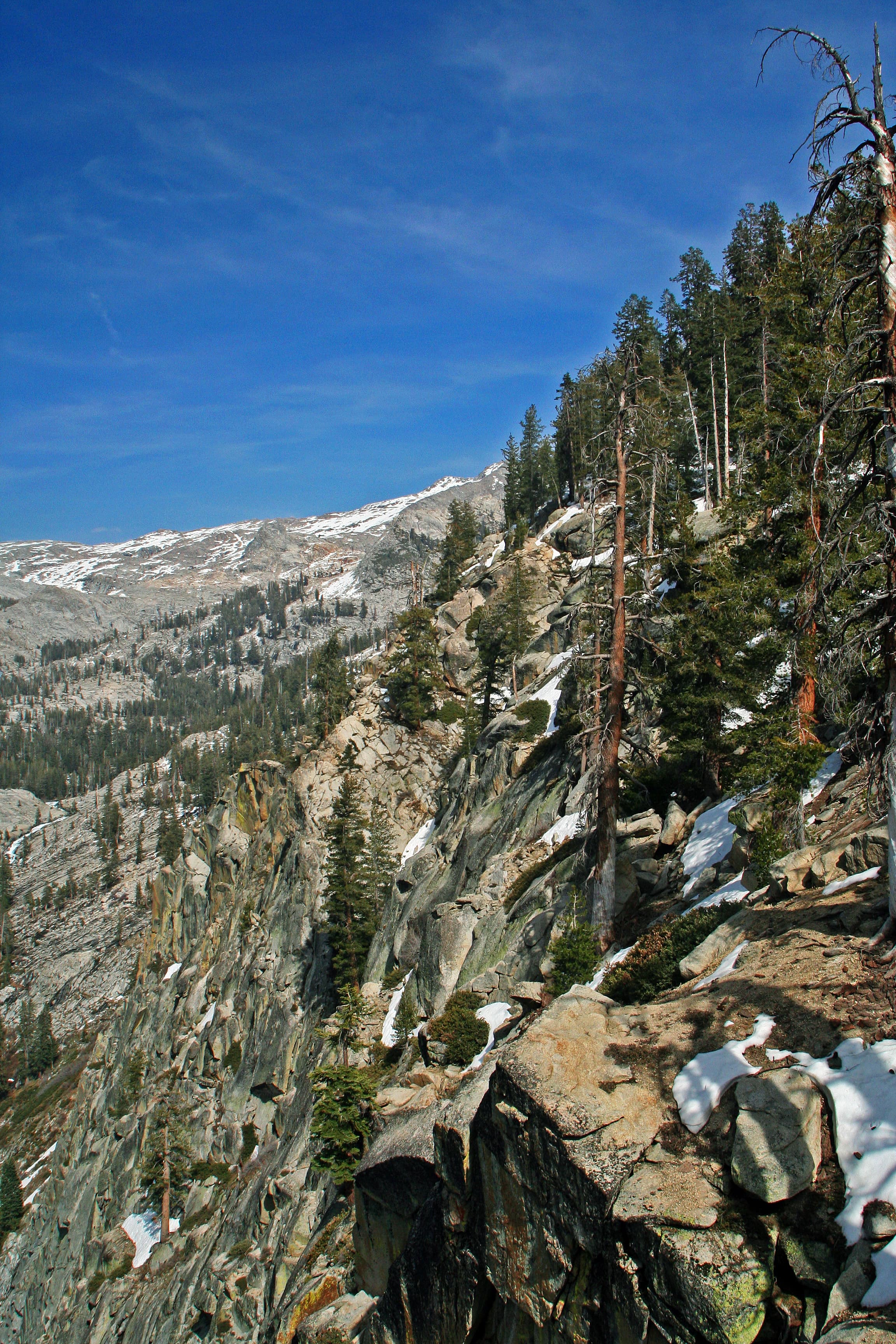
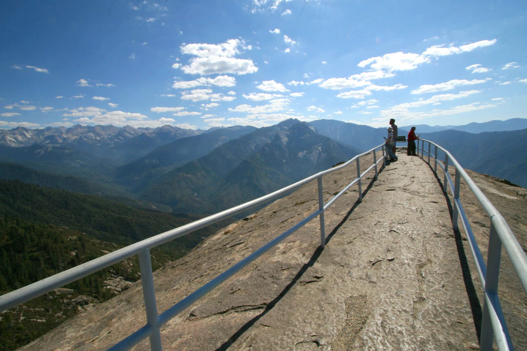
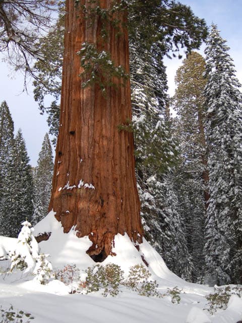
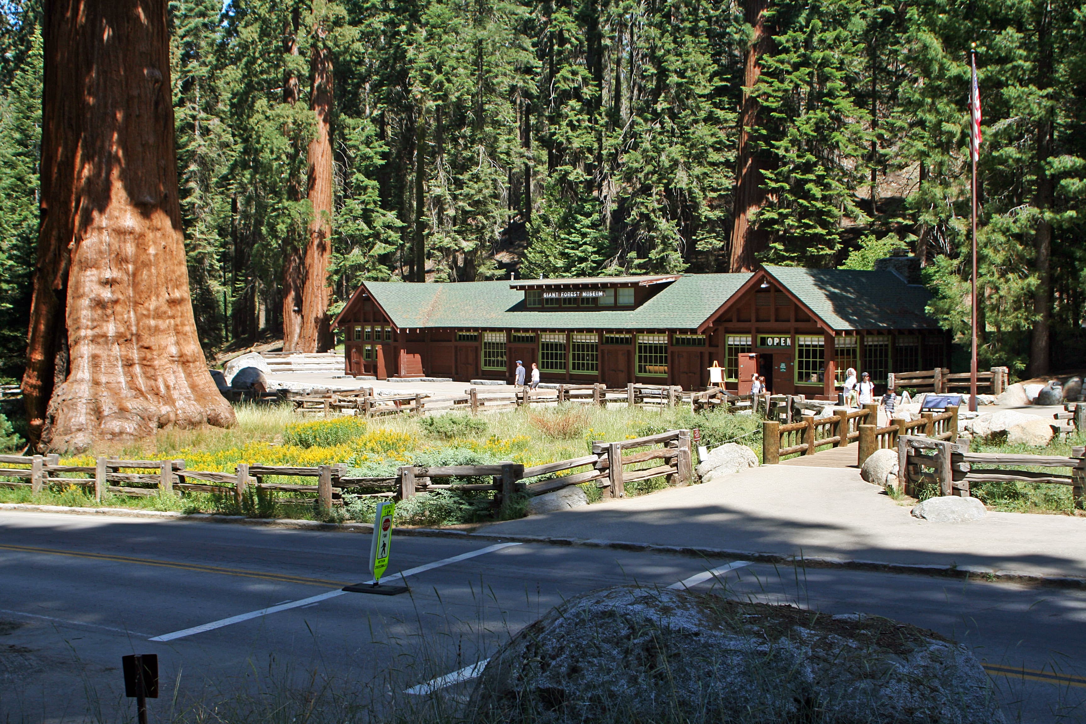
Stay near this park
No horse-friendly stays listed near Sequoia & Kings Canyon National Parks yet. Know a great barn or property? Help fellow riders by listing it.
List your propertyDirections
Two highways enter the parks. Hwy 180 from Fresno leads east to Kings Canyon National Park, then continues 30 miles east to Cedar Grove. Hwy 198 from Visalia leads east to Sequoia National Park via Three Rivers. Inside the parks, Highway 198 becomes the Generals Highway, which connects 198 to 180. Vehicles over 22-feet long should enter the parks via Highway 180. In winter, the Generals Highway between the parks often closes. Chains may be required on park roads. No roads cross the parks east to west.
Source: nps.gov