
Information
Fire restrictions: Stage II
Starting at 8:00 am on 6/26/2026, Valles Caldera and the Pueblo Parks Group is entering Stage II fire restrictions to reduce fire risk and prevent wildfires.
More infoInformation
Backcountry route open to vehicles May 15 - November 15
Valles Caldera's backcountry road system opens to vehicles on Friday, May 15, 2026. Forty vehicles passes will be issued per day through November 15, when the route closes for the 2026 season. Passes may be reserved up to 3 months in advance at Recreation.gov. Any remaining daily passes will be available on a first come, first served basis in the Volcano Discovery Center.
More infoInformation
Trail closure for pipeline restoration project
The VC09/South Valle Toledo/Posos Trail from the Valle Toledo parking area to the eastern park boundary is closed for restoration. The NPS is working on a trail reroute and will provide details as soon as possible.
More infoValles Caldera National Preserve
NM · Jemez Springs
About 1.2 million years ago, a spectacular volcanic eruption created a 14-mile-wide circular depression in the earth now known as Valles Caldera. The preserve is known for its huge mountain meadows, abundant wildlife, and meandering streams. The area also preserves the homeland of ancestral native peoples and embraces a rich ranching history.
Riding guide
Highlights
Valles Caldera National Preserve offers wide-open high-elevation meadows set within a massive ancient volcanic caldera in northern New…
Riding
Rideable terrain here is noted as 40-60 miles, giving riders a clearer sense of scale before they ever unload. Valles Caldera National Preserve offers wide-open high-elevation meadows set within a massive ancient volcanic caldera in northern New Mexico. Riders can explore expansive grasslands, forested ridges, and big-sky terrain on designated routes with their own horses. With sweeping views, abundant wildlife like elk and mule deer, and a true sense of Western openness, Valles Caldera delivers a peaceful and unforgettable backcountry riding experience for prepared equestrians.
Rideable terrain
40-60 miles
Trailer parking
Welcome Station Parking Lot (Primary Option) This is the most common staging area for equestrians. Location Near the main entrance Welcome Station. Parking details Horse trailers can park in designated corners of the lot as long as they do not block other visitor parking. The lot can typically accommodate about two horse trailers at a time. Access Riders can begin riding along nearby park roads and trails from this location. Important note After November 15, this becomes the only location where horse trailers may park in the preserve. Horse Barn Parking Area (Secondary Staging Area) Another permitted trailer parking area is located: Location North of the Baca Ranch Cabin District at the historic Horse Barn. Parking details Designed specifically for equestrian use. Accesses several nearby ranch roads and trail routes used by riders. Backcountry Road Parking (Permit Required) If riders want to haul deeper into the preserve: A Backcountry Vehicle Pass is required to drive trailers beyond the Horse Barn area. Parking is allowed only in designated areas or along roads where gates and traffic are not blocked. These passes are limited and typically must be reserved in advance. Capacity Limits The preserve strictly limits equestrian traffic: Maximum of 6 horse trailers in the park at one time Up to 12 horses total allowed with those trailers Parking is first-come, first-served and permits do not guarantee space.
Horse regulations
Know Before You Go The use of one (1) to 12 horses is permitted, provided that humane treatment is accorded the animal at all times and all regulations related to animal use are strictly observed. Much of the Park is over 8,000 feet in elevation. Acclimation of the horse is advisable. Each individual riding a horse is required to have a separate permit. A group of riders may not exceed twelve (12) persons/horses in any one party under this permit. Groups of thirteen (13) or more must apply for a separate group special use permit by contacting the park's Special Park Use Coordinator. The Permittee will keep a copy of the first two pages of this permit (or the wallet-size permit card) on their person while in the Park and place the vehicle permit on the dashboard of their vehicle. A backcountry vehicle pass is required if you wish to drive your vehicle and trailer into the backcountry before beginning your horseback ride. Passes are limited and available seasonally as conditions allow. Environmental and safety conditions (snowpack, erosion, flooding) can close certain trails to all public use. The Park does allow livestock grazing through a permit process and chances are likely that in some areas you will encounter wranglers working livestock. Rules of the Trail The Permittee is required to stay on trails specifically designated for equestrian use. The Permittee is prohibited from establishing new trails, and short cutting trails and switchbacks. Clearing of vegetation and riding off-trail is prohibited. The riding of a horse at a speed greater than a trot is not permitted. Multiple horses must travel in a single file. Riders shall not ride double except for an adult/child combination. Riders must be prepared to cross paths with other recreational users and vehicles. Youth riders (sixteen (16) years of age and under) must wear a helmet. With the exception of service animals, all domestic animals and pets are prohibited in the backcountry and on most park trails. Pets on leash are permitted within the Baca Ranch Cabin District and on the following hiking trails: Rabbit Mountain, Cerro La Jara, Cabin District, and South Valle Grande. Leave No Trace The use of USDA certified weed-free pelleted feed or hay is required while on the Park to prevent the spread of noxious weeds. All animals must be fed weed-free feed for 24 hours in advance of entering the Park. Animals must be tethered at least 300 feet from water sources and in a manner to prevent damage to live trees or shrubs and away from vegetation, alcoves, and archaeological sites to prevent damage. A high-line is permitted to tie horses between trees, provided the tree is ten (10) to sixteen (16) inches in diameter at breast height (DBH).When tying a high-line between trees a protective material must first be wrapped around the tree. A horse must be under physical control when watering directly from any creek or other body of water within the Park. Watering directly from any spring and feeding/grazing on plant life within the Park are prohibited. The Permittee will remove from the Park any excrement from around trailers and haul homes. Animals may not be stabled or corralled on Park property and must be removed from the Park at the end of the day. In places where animals are tethered, manure must be scattered at least 300 feet from water sources. Emergencies & Incidents Emergency procedures: The Permittee will immediately report life-threatening incidents, whether involving the Permittee’s group or other parties, by calling a 911 operator. The Park is located in Sandoval County at 39201 NM-4 or Mile Marker 39. Reporting accidents/injuries: The Permittee is required to formally report all incidents involving an accident, collision, fire, or injury within twenty-four (24) hours to NPS law enforcement staff through NPS Glen Canyon Dispatch at 928-608-6301, regardless of the extent of damages and in writing to the NPS permit coordinator. Helicopter evacuation or other emergency or special operation will be determined, arranged, and directed by the NPS.
Getting here
Use 39201 NM-4, Jemez Springs, New Mexico as your primary planning reference before you haul in. Welcome Station Parking Lot (Primary Option) This is the most common staging area for equestrians. Location Near the main entrance Welcome Station. Parking details Horse trailers can park in designated corners of the lot as long as they do not block other visitor parking. The lot can typically accommodate about two horse trailers at a time. Access Riders can begin riding along nearby park roads and trails from this location. Important note After November 15, this becomes the only location where horse trailers may park in the preserve. Horse Barn Parking Area (Secondary Staging Area) Another permitted trailer parking area is located: Location North of the Baca Ranch Cabin District at the historic Horse Barn. Parking details Designed specifically for equestrian use. Accesses several nearby ranch roads and trail routes used by riders. Backcountry Road Parking (Permit Required) If riders want to haul deeper into the preserve: A Backcountry Vehicle Pass is required to drive trailers beyond the Horse Barn area. Parking is allowed only in designated areas or along roads where gates and traffic are not blocked. These passes are limited and typically must be reserved in advance. Capacity Limits The preserve strictly limits equestrian traffic: Maximum of 6 horse trailers in the park at one time Up to 12 horses total allowed with those trailers Parking is first-come, first-served and permits do not guarantee space.
Planning your visit
Horse Trailer Parking There are two locations within Valles Caldera where horse trailers are allowed to park without a backcountry vehicle pass. The northeast corner of the parking lot at the Welcome Station can handle up to 2 horse trailers, so long as they are parked in a manner that does not impair the majority of the parking area from being used by other visitors. The parking area at the Horse Barn, north of the Baca Ranch Cabin District. In order to drive and park your trailer beyond the Horse Barn, a daily backcountry vehicle pass is required. Backcountry parking is allowed in designated areas and along roadways so long as gates and roadways are not blocked and so long as tall grass or other combustible material is not exposed to the undercarriage of the vehicle (exhaust systems, including the catalytic converter can be hot enough to cause ignition of flammable material). Parking along roadways must be in-line (parallel to direction of traffic flow with two (2) tires on the roadway) to limit obstruction to a minimum. No more than six (6) horse trailers, with up to twelve (12) horses, may be parked within the Park at any given time. Parking is limited and is on a first come first serve basis. This permit does not guarantee there will be available parking on any given day. After November 15, the only horse trailer parking available is at the Welcome Station.
Where to stay
Valles Caldera Welcome Station is the main visitor-contact point tied to this destination, which is helpful when you want current conditions, maps, and stock-use updates before riding. This entry reads best as a bring-your-own-horse destination rather than a horse-rental stop, and amenities should be confirmed directly before travel. For a polished trip plan, pair the ride with lodging, fuel, and resupply planning in or near Jemez Springs before heading deeper into federal-land access points.
Entrance fees & passes
- $25.00
Entrance - Private Vehicle
The entrance fee for a private vehicle covers seven consecutive days of entrance to Valles Caldera National Preserve.
- $20.00
Entrance - Motorcycle
Valid for 7 days. Admits up to 2 private, non-commercial motorcycles with up to 4 total passengers.
- $15.00
Entrance - Per Person
The per-person entrance fee covers seven consecutive days of entrance to Valles Caldera National Preserve.
- $45.00
Annual Entrance - Park
Beginning January 1, 2025, visitors may purchase an annual park pass for Valles Caldera National Preserve.
Trails
No trails synced for this park yet.
Campgrounds
No campgrounds listed for this park.
Points of interest
Banco Bonito
POIAccording to oral tradition, shortly after the Hemish people moved to the area, they established high altitude farming for corn, beans, and squash in the microclimates of Banco Bonito. To this day, this is the site of the highest elevation field houses ever discovered at approximately 8,000 feet. While archaeologists and visitors are amazed at this success, Chris Toya emphasizes that careful knowledge and stewardship enabled Hemish farming.
Birding By Car Stop 1
POIThis site, near the South Valle Grande Trailhead along NM State Route 4, is predominantly mixed conifer forest and woodland (both dry and moist mesic). Prevalent plant species include blue spruce and ponderosa pine, fox tail, wildflowers, and yarrow. Watch for these birds each season: Winter: Dark eyed junco Spring: Northern flicker Summer: Pine siskin Fall: House finch
Birding By Car Stop 2
POIThis overlook along NM State Route 4 is very open, with amazing views into Valle Grande. We are near the transition zone between dry mixed conifer forest and the upper montane grasslands, which often means we'll have a great variety of bird species nearby.
Birding By Car Stop 3
POIThis spot along Valles Caldera's entrance road showcases the East Fork Jemez River, its wetland, and surrounding montane grasslands.
Birding By Car Stop 4
POIAt the entrance station, we are surrounded by montane grasslands. Across the road is a small, forested lava dome called Cerro La Jara. If you're looking for a short hike with lots of wildlife watching opportunities, there's a wonderful 1.4-mile loop trail around the lava dome. In the summer, these grasslands explode with wildflowers of all types. In the winter, they get covered up by several feet of snow.
Birding By Car Stop 5
POIAt the Ranger Station, we are at the transition zone between old-growth ponderosa pine forest and montane grasslands. This is an outstanding area to watch for a variety of birds.
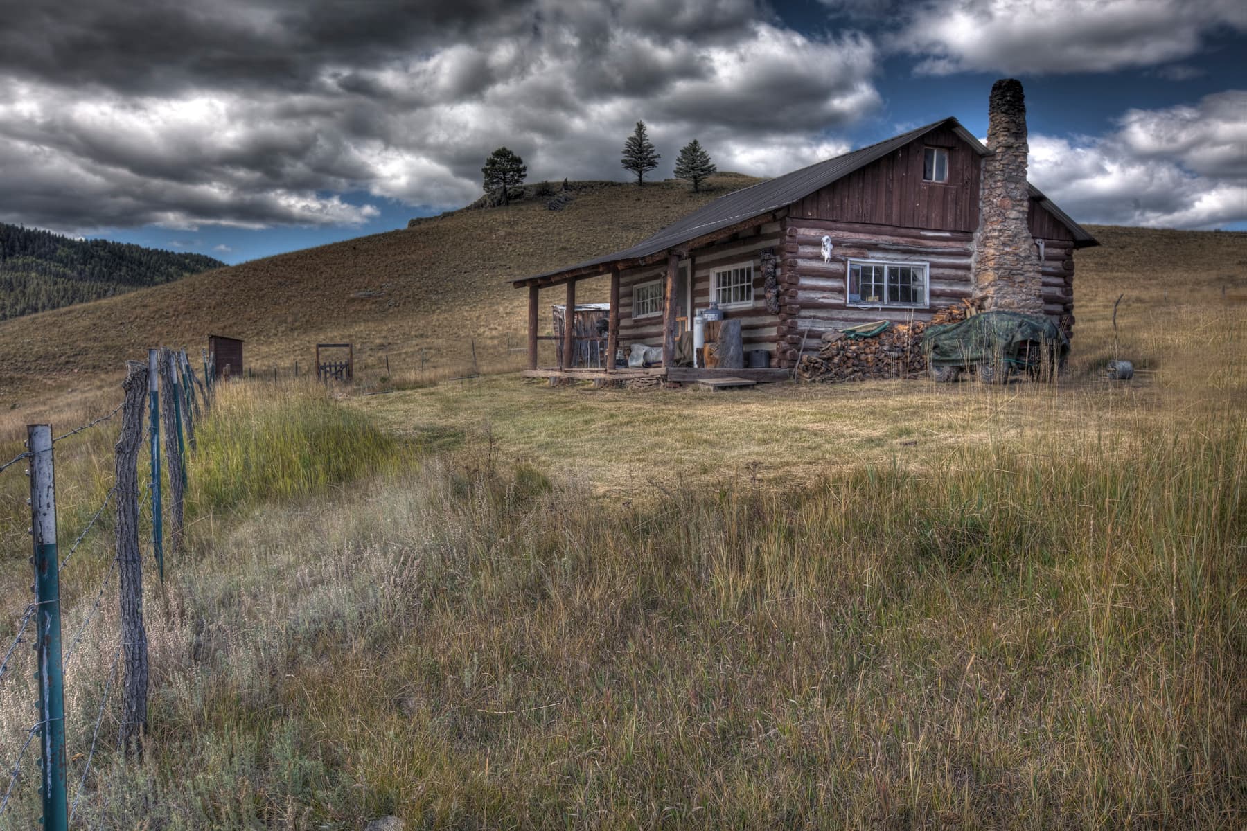
Bond Cabin
POIBuilt in 1918 and known as the "Big House," it served as a seasonal home for the Bond family and functioned as the official ranch headquarters. The living room fireplace and wood-burning stove heated the building, and the cooking was done mostly outdoors. An outhouse was used until the Dunigan family remodeled in the 1980s.
Caretaker's Cabin
POIIt is unclear if this building was constructed or moved here in 1951, but it was used to house Ruby and Robert Hoolihan, employees of the Bond Family who owned the land from 1918 to 1963.
Cerro Del Medio
POICerro del Medio began erupting approximately 1.1 million years ago and continued for about 25,000 years. Its lava flows created very high-quality obsidian for human use. A very sharp and shiny black rock, obsidian can be fashioned or “knapped” into tools, spear points, and arrowheads. It was also used as a form of currency, traded across long distances in the Americas.
Cerro La Jara Stop 1
POIWelcome to the Cerro la Jara Trail in Valles Caldera National Preserve. This trail is about 1.5 miles (2.4 km) long and will likely take 1 to 2 hours to complete.
Cerro La Jara Stop 2
POIYou are walking in a volcanic caldera – a depression formed during a volcanic eruption. This caldera was formed as the result of a very large volcanic eruption about 1.2 million years ago. It is somewhat circular in shape and 12 to 15 miles across.
Cerro La Jara Stop 3
POIAlluvial fans get their name from their shape and what they are made of. Rocks, sand, and silt moved and deposited by running water is called alluvium. Alluvial fans are fan shaped deposits of alluvium. Water flowing downhill out of the mountains moves the sediment downhill and deposits it in the valley.
Cerro La Jara Stop 4
POIVolcanic domes are formed by the extrusion of lava that piles up in a dome shape. Cerro la Jara and South Mountain were formed about 700,000 years after the eruption that formed Valles Caldera. They are both made of a rock called rhyolite.
Cerro La Jara Stop 5
POIA resurgent dome is different than a volcanic dome; it wasn’t extruded as lava. The resurgent dome was created as magma pushed part of the newly formed valley up from underneath. To understand this better, think of how the upper crust of an apple pie is lifted by the bubbling apples underneath it – the magma pushed the valley floor up, like the hot apples push up the upper pie crust.
Cerro La Jara Stop 6
POIThe volcanic dome, Cerro La Jara is still to your right. This is a good place to see flow banding in the rocks. The banding looks like layers in the rock and indicates that either different lava flows or different lava composition, or both, made the rocks break down and weather differently.
Cerro La Jara Stop 7
POICerro del Medio is a volcanic dome that was formed a few tens of thousands of years after the caldera collapse, when a large lake partly filled Valle Grande. It was the first volcanic dome to erupt after formation of the caldera. The lava that formed the volcanic dome was very hot and contained a lot of silica. It cooled quickly, possibly because it was erupted underwater, and formed rocks called rhyolite and obsidian.
Cerro La Jara Stop 8
POISo, will the volcano erupt again? When might it erupt? Good questions – what we do know is that there would be plenty of warning signs first. There would be lots of small earthquakes, and the ground temperature and the temperature of water in the springs would increase.
Cerro La Jara Trailhead
POIThis 1.5-mile (2.4 km) loop trail circles Cerro La Jara, the smallest volcanic dome in the park, which formed about 500,000 years ago when lava oozed up and onto the caldera floor. South Mountain, to the west, and Cerro del Medio, on the opposite side of Valle Grande, are also volcanic domes and can be seen from this trail.
Cerros del Abrigo
POIA popular area for elk hunters today and a frequented hiking area, Cerros del Abrigo was also the site of an important hunting camp for the Hemish people and positive spiritual energy. Keep an eye out for elk and black bear and listen for the distinctive cry of the pika.
Commissary
POIThe commissary supplied basics like meat, potatoes, beans, and other canned goods for ranch workers and sheep camps. Sheepherders arriving on horseback, packed burros, and mules would stock up with weeks' worth of provisions and then return to their camps in the mountains.
Cowboy Cabin
POIThe Bond Family built this house in 1951 for ranch employee Sam Hill, his wife Bertilla, and their two children after Sam complained about the building of the red cabin for the Hoolihans.
East Fork Jemez River
POIExcellent views and fishing opportunities await you on the East Fork Jemez River.
Historic Cabin District
POIHistory Grove
POIA pocket of remaining old-growth forest in Valles Caldera featuring 250-400 year old ponderosa pines and Douglas firs.
Jaramillo Creek
POISkilled anglers will delight in catching massive brown trout in this world-class flyfishing stream.
Main Park Entrance
POIThe main entrance to Valles Caldera National Preserve, located along New Mexico State Route 4 between Los Alamos and Jemez Springs, is open daily from dawn to dusk for pedestrian traffic and from 9:00 am to 5:00 pm for vehicular traffic (8:00 am to 6:00 pm from Memorial Day to Labor Day). Learn more about our operating hours and alternative park entrances at https://www.nps.gov/vall/planyourvisit/hours.htm.
NM State Route 4 Pullouts
POIThere are several pullouts along NM State Route 4 to stop and view wildlife, take photos, and enjoy expansive views of Valle Grande. These pullouts are open 24/7, so they may also be used for stargazing.
Old Barn
POIBuilt in 1941, the Old Barn was used to store hay, straw, tack, and the "night horse." Every morning, the night horse and assigned ranch hand would be up before sunrise to bring the other horses from the field. The opening on the right was enlarged sometime prior to 1955.
Otero Cabin
POIThe Otero (Cupit) Cabin is the oldest standing log structure in the park, built back in 1915. The Oteros, who owned the land from 1899 to 1918, grazed sheep on the mountains and cattle and horses in the valleys. Frederico Otero lived there until 1917, but later occupants included staff working seasonally on the ranch. Names carved over the door frame include Danny, Shawn, and Nathan Cupit and are dated 1967 and 1977.
Ranch Foreman's Cabin
POIKnown as the "Little House," this cabin housed the ranch manager. Like the Bond Cabin, cooking was primarily done outdoors until the Dunigan family remodeled in the 1980s. In both cabins, the additions can be easily recognized because they used vertical board/batten framing instead of horizontal logs. This cabin had continual ranch management use from 1918 up until the early 2000s. It was featured in the show Longmire.
Redondo Peak - Resurgent Dome
POIRedondo Peak is not only a world-class example of caldera resurgence, but it is also a sacred peak to many indigenous cultures. In Hemish culture, for example, Redondo Peak is the center of the universe. It is the home of their deities and ancestors. Redondo is life for the people of the Pueblo of Jemez.
Saddle Shed
POIThe saddle shed, also known as the tack shed, was built in 1963 to serve ranch operations. Ranch hands started their days here, grooming their horses and saddling up before sunrise. They would ride up to 20 miles a day, checking on livestock, inspecting fences, and tending to other chores throughout the 100,000-acre property.
San Antonio Creek
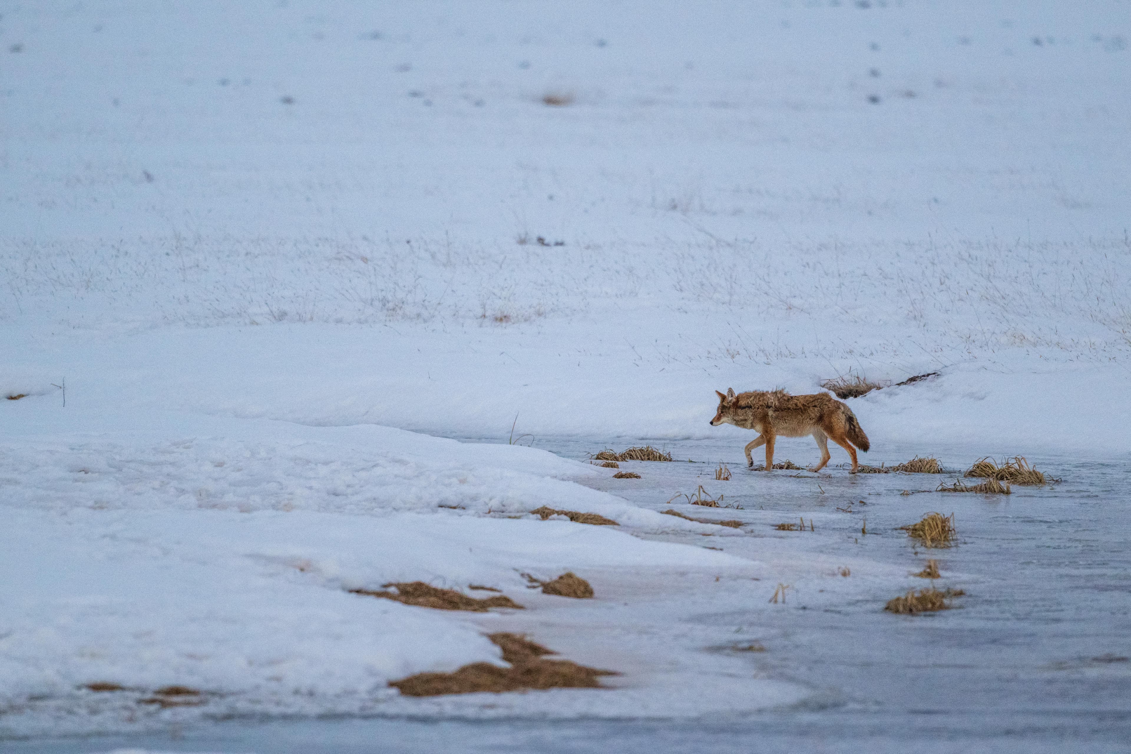
POIBelow the north rim of the volcanic caldera and about 12 miles from the Entrance Station, San Antonio Creek meanders through the lush mountain meadows of Valle San Antonio and is home to thousands of non-native brown trout. Elk, bear, coyote, and mountain bluebirds are often spotted along the banks of the creek.
South Mountain
POIFor many visitors, South Mountain is a popular hiking, cross-country skiing, and snowshoeing destination. For indigenous cultures across the Southwest, including Hemish culture, South Mountain also holds spiritual and ceremonial importance.
Stop 10: Cerro Del Medio
POICerro del Medio began erupting approximately 1.1 million years ago and continued for about 25,000 years. Its lava flows created very high-quality obsidian for human use. A very sharp and shiny black rock, obsidian can be fashioned or “knapped” into tools, spear points, and arrowheads. It was also used as a form of currency, traded across long distances in the Americas.
Stop 11: Cerros Del Abrigo
POIA popular area for elk hunters today and a frequented hiking area, Cerros del Abrigo was also the site of an important hunting camp for the Hemish people and positive spiritual energy. Hear Chris Toya talk about the mindset and perspective you should have before hiking or hunting in the area. Keep an eye out for elk and black bear and listen for the distinctive cry of the pika.
Stop 12: Other Tribal Connections
POIWhile this tour has focused on Hemish connections, Valles Caldera has 38 affiliated tribal nations including the Southern Ute nation. Hear Chris Toya discuss the long history of human occupation in Valles Caldera and the connections of the Southern Ute people to Valle Grande.
Stop 13: Banco Bonito
POIAccording to oral tradition, shortly after the Hemish people moved to the area, they established high altitude farming for corn, beans, and squash in the microclimates of Banco Bonito. To this day, this is the site of the highest elevation field houses ever discovered at approximately 8,000 feet. While archaeologists and visitors are amazed at this success, Chris Toya emphasizes that careful knowledge and stewardship enabled Hemish farming.
Stop 1: Entrance Plaza
POIWelcome to Valles Caldera National Preserve! "Spanish Place Names & Origins" is a driving tour designed to explain the Spanish origins of some of the key landmarks of Valles Caldera National Preserve. The tour will guide you to roadside locations where you can observe each of the described landmarks from your car. Each stop will include a short history background and some pronunciation assistance.
Stop 1: Sulphur Creek Trailhead
POIWelcome to the Sulphur Creek Trailhead! Sulphur Springs is about 0.5 mile along the road after you pass through the entrance gate. The total hike, including the loop within Sulphur Springs, is about 1.5 miles. This area is off limits to pets due to safety concerns. Pets could be injured by the hot acidic water present. Please bring drinking water, use caution near hydrothermal features, and enjoy this unique part of Valles Caldera!
Stop 1: Welcome to the Park!
POIByron Andrew, Mark Magdalena, Brophy Toledo, and Chris Toya all belong to the Pueblo of Jemez. They introduce themselves both in Towa and English and explain their positions in Hemish society. During these introductions, you will hear a bit about the religious and social societies that most Hemish men and women are a part of. You will also hear about “power points,” places of special religious and spiritual significance to the Hemish.
Stop 2: Entrance Station
POIWhile this tour by design focuses on connections to specific places in Valles Caldera, the Hemish emphasize their ties to the entirety of Valles Caldera. From approximately 1100 C.E. to the 1600s C.E., the Hemish lived and practiced high elevation agriculture in the mountains without the megafires that have dominated the post-2000 landscape.
Stop 2: Tuff Spires
POIThe conical rock spires to your left are the 1.25-million-year-old Deer Canyon Member, which is made up of tuff and rhyolite. A tuff is a rock that is formed during and immediately after a violent volcanic eruption. This tuff is composed of rock crystals such as quartz and sanidine feldspar, chunks of pre-existing rock forced up during the explosion, and volcanic ash that either fell out of the air or was deposited by ground-hugging pyroclastic flows.
Stop 2: Valle Grande
POIThe valley you are looking at is called “Valle Grande” — this translates to ‘Big Valley’ in Spanish. Bernardo Miera y Pacheco completed one of the earliest remaining maps we have of the Northern New Mexico region, including the Valley you are looking at right now.
Stop 3: Cerro La Jara
POIAcross the road from the Welcome Station is Cerro La Jara. The first recording of the name “La Jara” is found on a map from 1892. There are a few theories as to the origins of the name but the most likely origin comes from the trees of northern New Mexico. Jara is a New Mexico-Spanish name given to reed and willow, specifically the coyote willow plant.
Stop 3: Sulphur Springs
POIYou have arrived at Sulphur Springs. You likely smell a “rotten egg” smell. This is hydrogen sulfide gas escaping from the springs, mudpots, and fumaroles. Valles Caldera is a dormant, but not extinct, volcano, and hydrogen sulfide and carbon dioxide gases escape from the partly crystallized magma that lies about 4 to 6 miles below the surface. You will see bubbles of gas escaping from the water or mud as you walk around the area.
Stop 3: Valle Grande
POIThe visually stunning Valle Grande was once used and frequented by multiple indigenous nations. For the Hemish and other native peoples, land ownership did not follow European conceptions of rigid lines signifying complete control. Valle Grande was a traditional pasture for Hemish horses, a hunting area, and the site for important religious activities. Hear tribal historian Chris Toya discuss the ties both ancient and present between Jemez Pueblo and Valle Grande.
Stop 4: Footbath Spring
POIFootbath Spring is quite acidic with a pH value of between 1.7 and 3. For comparison, lemon juice has a pH of 2.2, and battery acid has a pH of 1. The temperature of this spring has been measured at about 75 degrees F and at 103 degrees F only a few weeks apart.
Stop 4: "Place of the Douglas Fir"
POIProminent in Valle Grande as a single, tree-covered mound rising from the surrounding grasslands, Cerro La Jara has significant cultural and religious importance to the Hemish people. Hear about the value of observing nature and the changing seasons at La Jara, the name of Douglas fir in the Towa language, and the history of Hemish horse grazing in the area.
Stop 4: Redondo
POIThe volcanic formation you are looking at now is called Redondo Peak. This name was first seen on maps in 1892. Before that, it was named Cerro Pelado, which translates to Bare Hill. This volcanic formation has had many variations of the same name including Sierra Redondo and Mt. Redondo. Although Redondo is Spanish for "round," there is no historical evidence suggesting that the name comes from its shape.
Stop 5: Jaramillo Creek
POIJaramillo Creek was first seen on the map in 1892 as “Arroyo Jaramillo.” Arroyo is Spanish for "dry stream”—a stream that is dry at times, and flowing at others. There are two likely sources for this name.
Stop 5: The Mexican Gray Wolf
POIValles Caldera and the Jemez Mountains were once home to the Mexican wolf or “lobo.” Subject to a federal government eradication campaign, rancher John Davenport shot the last wolf on what was then the Baca Ranch in 1932. They were extinct in the wild by 1970. After a successful reintroduction in 1998, Valles Caldera saw a brief return of the Mexican wolf in December 2023. A keystone species in the ecosystem, the wolf is an important animal for the Hemish people.
Stop 5: Tony's Spring
POIThe spring here is called Tony’s Spring or Excavator Spring. It is a hot, bubbling spring with fumaroles surrounding it. According to local legend, this spring was formed when someone (maybe Tony?) dug down in the hillside and hit hot water. The temperature of the spring was measured at 120 degrees F in June of 2024.
Stop 6: Cerros Del Trasquilar
POIIf you look to your left, you’ll see Cerros Del Trasquilar. This name is Spanish for “Shearing Hills.” To your right is Cerros Del Abrigo, which has many Spanish interpretations. It can mean “Hills of Shelter or Protection” or “Coat Hill/Hills of the Coat.” Both of these names reference the sheepherding history of Valles Caldera.
Stop 6: Men's Bathhouse Spring
POIThis is Men’s Bathhouse Spring. You can still see part of the wooden structure that remains from when it was used as a sauna. Generally, this spring has limited water and is full of bubbling mud - a mudpot. The gases escaping in the bubbles are hydrogen sulfide and carbon dioxide. You will likely smell the hydrogen sulfide – it smells like rotten eggs. Mudpots are generally hot and acidic and this one is no exception. The temperature of this spring is about 140 degrees F.
Stop 6: Waavema
POIOne of the most sacred places in the Hemish universe is Waavema, known to most visitors as Redondo Peak. Waavema is critical to the story of Hemish migration to the mountains of northern New Mexico. The eagle created by the aspen trees, meadows, and mixed conifers on the South aspect of Waavema signaled that this place would be the home of the Hemish people. The Thompson Ridge fire of 2013 significantly damaged this motif. As Chris Toya says, “Redondo is life.”
Stop 7: Antler Mountain
POIFor many visitors, South Mountain is a popular hiking, cross-country skiing, and snowshoeing destination. Hear Chris Toya and Brophy Toledo discuss the spiritual importance of “Antler” mountain and the origin of this name in the Towa language. They also provide an important message to visitors about respecting Native land.
Stop 7: Electric Spring
POIThe spring to your left is called Electric Spring. It is warm – around 94 degrees, but with an acidity rivaling that of battery acid.
Stop 7: Valle Santa Rosa
POIThe name "Valle Santa Rosa" is a direct reference to Spanish colonization in the Americas. Santa Rosa, or St. Rose, is the patron saint of all Spanish territory in the western hemisphere. The history of Santa Rosa is intrinsically tied to the development of Spanish missions all over the Americas. The first time we see Valle Santa Rosa appear on a map is in 1892.
Stop 8: Final Look
POIAs you explored Sulphur Springs, you may have seen additional fumaroles and springs away from the path. Some have names, many don’t. Sometimes new ones just appear - or old ones disappear! Did you see any fumaroles with bright yellow crystals near the opening? The crystals are pure native sulfur deposited when hydrogen sulfide escapes the fumarole.
Stop 8: The Cabin District
POIWhile the cabin district is popular with visitors and fans of the television show Longmire, few are aware of the human history before the 20th century. In the Towa language, it is called “place of the willows” and was a key site to procure medicinal plants.
Stop 8: Valle San Antonio
POIYou are now in Valle San Antonio. We first see Valle San Antonio labeled as such on a map in 1890. The name San Antonio is Anglicized Spanish for St. Anthony. This valley is named after St. Anthony of Padua of the Franciscan order, patron saint of travelers and Indigenous peoples of the Americas.
Stop 9: The Bond Cabin
POIAccess to and use of traditional lands changed dramatically in the late-19th and early-20th centuries. While the title of the land passed formally to the Baca family in 1876 and eventually to the Bond and Dunnigan families, the Hemish people long fought for their claims and rights.
Stop 9: Valle Toledo
POIThe Spanish utilized the practice of naming encountered territories based on resemblances to familiar places in their homeland. For example, Toledo is a mountainous municipality located in central Spain. The speculation is that this valley was named Valle Toledo after the resemblance. Toledo is also a common Spanish last name in this region of New Mexico.
Sulphur Canyon
POISulphur Springs contains volcanic features like sulfuric-acid hot springs, volcanic fumaroles and steaming mud-pots, and supports a range of “extremophile” algae and bacteria living in the high-temperature acidic pool and stream environments. Many of the geothermal features on the property are found nowhere else in New Mexico, and similar sites are very rare in the western United States.
The Movie Set Cabin
POILocated on Valles Caldera's main entrance road, approximately a half mile from NM State Route 4, this cabin is part of the 2003 "The Missing" movie set starring Tommy Lee Jones and Cate Blanchett. Park at the Jemez River Trailhead and walk a quarter mile up the trail beyond the cable gate. Please do not block the cable gate with your vehicle. Dogs are not allowed at the cabin or on the trail.
The San Antonio Cabin
POISan Antonio Cabin often housed cowboys when this land was privately-owned and operating as a ranch.
Valle Grande
POIValle Grande is the largest and most prominent valley within Valles Caldera, but it only makes up about 15% of the total land area of the caldera.
Valle Grande Pond
POIVolcano Discovery Center
POIThe story of Valles Caldera comes to life at the Volcano Discovery Center, located 4 miles down the main entrance road within the Cabin District. Experience an immersive simulation of the Valles Caldera eruption every hour on the half-hour. Interact with the multisensory park exhibit to learn about geology, cultural history, ecology, and scientific discovery in the caldera. Visit with rangers and volunteers. Peruse the park store for souvenirs.
Things to do
Bike the Alamo Canyon to Valle Seco Lasso
The Alamo Canyon to Valle Seco Lasso is a 13.5-mile bike route through the western portion of Valles Caldera National Preserve. This ride features 1,800 feet of elevation gain and a speedy final descent through the park's densest concentration of geothermal features.
Duration: 4-6 Hours
Bike the Redondo Foothills Loop
The Redondo Foothills Loop is a moderately strenuous, 9.5-mile bike route beginning in the Cabin District. This ride features flowy descents, 771 feet of climbing, and great views of Valle Grande.
Duration: 2-3 Hours
Bike the Valle Grande Loop
This bike route loops around Valle Grande, providing spectacular views along the entire route.
Duration: 3-5 Hours
Cross-Country Skiing in Valles Caldera
Winter is a spectacular time to visit Valles Caldera National Preserve. The park has miles of groomed trails for the adventurous skier.
Fish in Valle San Antonio
San Antonio Creek is famous throughout New Mexico for wild brown trout and beautiful scenery. Reserve your backcountry vehicle pass to fish this stream seasonally from May 15 - November 15.
Fish San Antonio Creek
San Antonio Creek is famous throughout New Mexico for wild brown trout and beautiful scenery. Reserve your backcountry vehicle pass to fish this stream seasonally from May 15 - November 15.
Fish the East Fork Headwaters
Hike or bike the Rincon Trail to the East Fork headwaters, where wild rainbow trout and browns predominate.
Fish the East Fork in Hidden Valley
Hike the Jemez River Trail to Hidden Valley, where the Rio Grande chub, Rio Grande sucker, and longnose dace are the dominant fish species.
Fish the East Fork Jemez River
A picturesque and meandering stream, wild rainbow trout and browns can be found in the headwaters of the East Fork of the Jemez River. Rio Grande suckers and Rio Grande chubs predominate elsewhere.
Fish the Headwaters of San Antonio Creek
San Antonio Creek is famous throughout New Mexico for wild brown trout and beautiful scenery. Reserve your backcountry vehicle pass and drive to Valle Toledo to fish this stream's headwaters!
Fish the Middle Jaramillo Creek
Jaramillo Creek is the middle of the three fishable streams in Valles Caldera. The middle section of the creek runs from Cerro Pinon upstream to the Cerro Abrigo Trailhead.
Fish the Upper Jaramillo Creek
The upper stretch of Jaramillo Creek offers a challenge for anglers with the reward of catching some truly large brown trout. The creek meanders through the lush Valle Jaramillo, which creates pools and overhanging banks for trout to hide in.
Hike the Cabin District Interpretive Trail
The Cabin District Interpretive Trail is a gentle, 0.6-mile round-trip route through the historic ranch headquarters for Baca Land & Cattle Company. It takes 30-60 minutes to complete. Leashed pets are welcome.
Duration: 30-60 Minutes
Hike the Cerro Abrigo Loop
This 7.2-mile (11.6 km) loop gently ascends a lava dome and then contours around it, offering great views of the eastern half of the caldera. This hike takes 3-4 hours to complete. Pets are not permitted.
Duration: 3-4 Hours
Hike the Cerro Del Medio Loop
This 13.8-mile (22.2 km) loop circles Cerro Del Medio, Valles Caldera's oldest lava dome. The hike takes 7-8 hours. Pets are not permitted.
Duration: 7-8 Hours
Hike the Cerro La Jara Loop
The Cerro La Jara Loop is a gentle, 1.4-mile hike around Valles Caldera's smallest and youngest volcanic dome. The hike takes approximately 1 hour. Leashed pets are permitted.
Duration: 1-2 Hours
Hike the Cerro Seco Loop
The Cerro Seco Loop is a strenuous, 11.2-mile round-trip hike that circles a lava dome with fantastic views of the caldera's north rim. It takes 5-6 hours to complete. Pets are not permitted.
Duration: 5-7 Hours
Hike the Garita Trail
The Garita Trail is a 7.6-mile round-trip hike to the northern rim of Valles Caldera. It takes 3-4 hours to complete. Pets are not permitted.
Duration: 3-5 Hours
Hike the Indios Creek Trail
The Indios Creek Trail is a 7.8-mile round-trip hike that follows a creek to the northern boundary of the park. It takes about 4 hours to complete. Pets are not permitted.
Duration: 2-4 Hours
Hike the Jemez River Trail
The Jemez River Trail (formerly Hidden Valley Trail) is a 3.4-mile round-trip hike into a picturesque canyon along the East Fork Jemez River. The hike takes 1-2 hours. Pets are not permitted.
Duration: 2-3 Hours
Hike the Northwest Rim Trail
At 18.6 miles round-trip, the Northwest Rim Trail is ideal for trail runners. At an average hiking pace, it takes 9-10 hours to complete. Pets are not permitted.
Duration: 9-10 Hours
Hike the Rabbit Mountain Loop
The Rabbit Mountain Loop (2.9 miles, 4.7 km round-trip), formerly known as the Coyote Call Trail, contours along the southern rim of the caldera, offering great views of Valle Grande and Redondo Peak. The loop takes 1-2 hours. Leashed pets are permitted.
Duration: 1-2 Hours
Hike the Rabbit Ridge Trail
The Rabbit Ridge Trail is a 2.4-mile round-trip hike that climbs to the south rim of Valles Caldera. It takes 1-2 hours to complete. Pets are not permitted.
Duration: 1-2 Hours
Hike the San Antonio Mountain Trail
The San Antonio Mountain Trail is a strenuous, 11-mile round-trip hike that climbs to the summit of San Antonio Mountain. It takes 5-6 hours to complete. Pets are not permitted.
Duration: 5-6 Hours
Hike the South Mountain Trail
The South Mountain Trail is an 8.2-mile round-trip hike that climbs to the summit of South Mountain. The hike takes 4-5 hours to complete. Pets are not permitted.
Duration: 3-4 Hours
Hike the South Valle Grande Trail
The South Valle Grande Trail is a 2-mile round-trip hike that descends to the edge of Valle Grande, offering excellent wildlife viewing opportunities. The hike takes 1-2 hours. Leashed pets are permitted.
Duration: 1-2 Hours
Hike the Sulphur & Alamo Canyon Loop
The Sulphur & Alamo Canyon Loop is a strenuous, 12.2-mile trail through Valles Caldera's geothermal areas. It takes approximately 6 hours to complete. Pets are not permitted.
Duration: 6-8 Hours
Hike the Valle Grande Exploration Trail
The Valle Grande Exploration Trail (formerly known as the Pond Trail) is a gentle, 0.8-mile round-trip hike to a pond in the heart of Valle Grande. It takes approximately 1 hour to complete. Pets are not permitted.
Duration: 30-60 Minutes
Hike to History Grove
Located about 0.8 miles (1.3 km) beyond the Volcano Discovery Center, History Grove is one of the last remaining pockets of old-growth forest in Valles Caldera National Preserve.
Duration: 1-2 Hours
Hike to Sulphur Springs
Sulphur Springs—a site bubbling with geothermal activity—is accessed via a 1-mile (1.6-km) round-trip hike on the Sulphur Creek Trail. This hike takes approximately 30-60 minutes. Pets are not permitted.
Duration: 30-60 Minutes
Hiking in Valles Caldera
Hiking routes within Valles Caldera range from flat strolls through montane grasslands to steep climbs on forested lava domes. As this land was a private ranch for over 150 years, the majority of hiking routes follow old logging and ranching roads. Since Valles Caldera is a relatively new National Park Service site, trails are not well-marked, and most trailheads do not yet have signs. For this reason, it is important for hikers to carry a detailed park map and GPS.
Horseback Riding from the Welcome Station
Enjoy the beauty of Valle Grande as you trek down the entrance road on your own horse.
Horseback Riding in Valles Caldera
With Valles Caldera's rich ranching history, horses have been part of this landscape for over 100 years. Learn about how to participate in this legacy and ride your horse at Valles Caldera National Preserve today.
Hunting in Valles Caldera
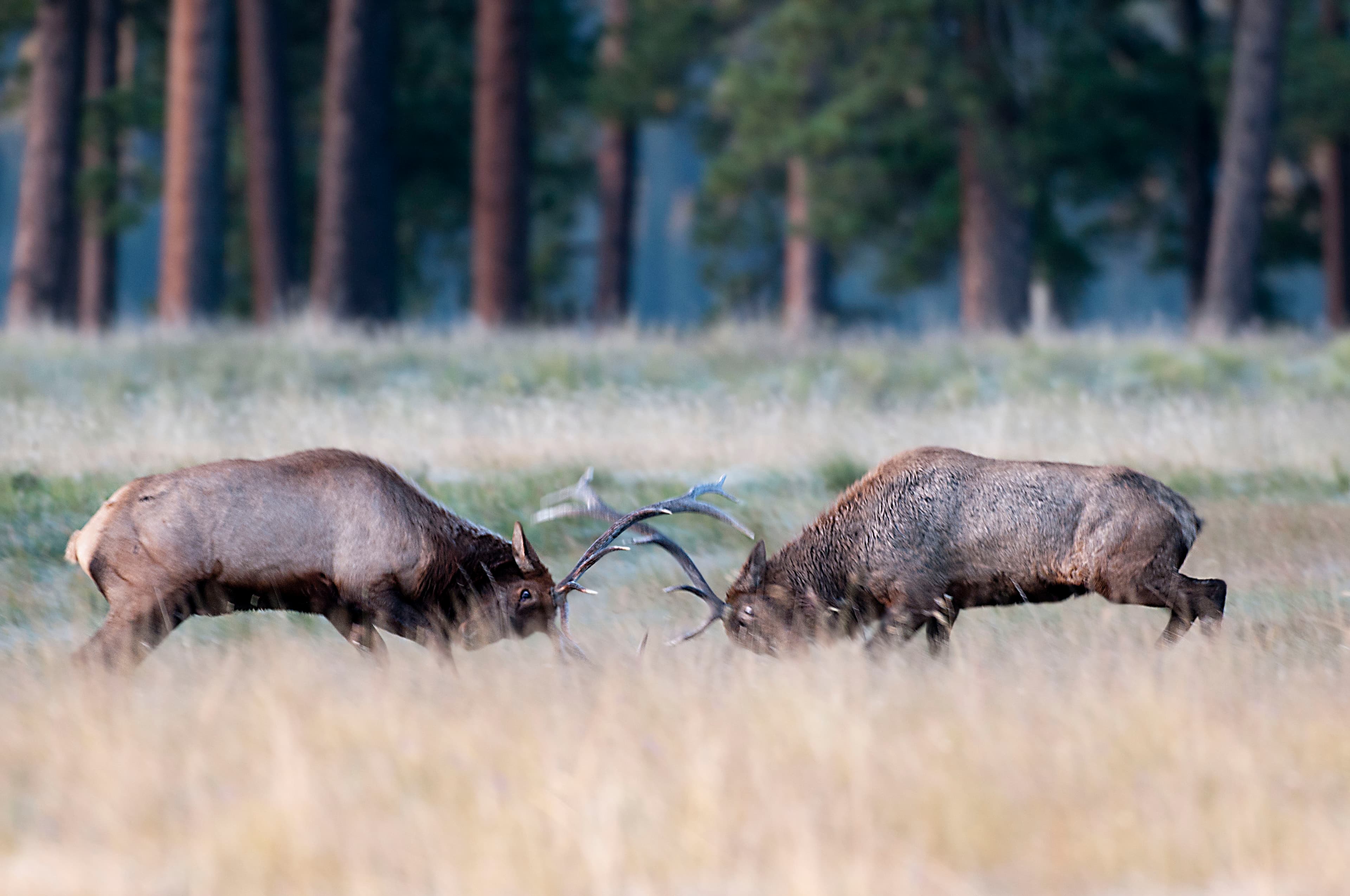
Valles Caldera National Preserve is one of New Mexico's premier elk hunting locations. Between 2,500 and 3,000 elk occupy the preserve for breeding, calving and foraging.
Ski the Cerro La Jara Loop
This 1.5-mile (2.4 km) ski loop circles Cerro La Jara, the smallest volcanic dome in the park, which formed about 500,000 years ago when lava oozed up and onto the caldera floor.
Duration: 1-2 Hours
Snowshoeing in Valles Caldera
Winter is a spectacular time to visit Valles Caldera National Preserve. The park has miles of groomed and ungroomed trails for the adventurous snowshoer.
Stargaze in Valles Caldera
As an International Dark Sky Park, Valles Caldera National Preserve offers outstanding opportunities for night sky viewing along NM State Route 4 and through regularly scheduled programs.
Take a Scenic Drive through Valle Grande
The Valles Caldera Entrance Road is a scenic, four-mile-long gravel road through the heart of Valle Grande. This drive offers outstanding wildlife viewing opportunities, volcanic vistas, and several places to get out and explore on foot.
Duration: 30-90 Minutes
Take a Self-Guided Auto Tour of Valles Caldera
This self-guided driving tour leads visitors through Valles Caldera National Preserve while recommending various stops at photo locations, geologic features, and historic structures.
Duration: 3-4 Hours
Take a Self-Guided Geology Hike Around Cerro La Jara
This self-guided geology tour in the National Park Service smartphone app leads hikers around Cerro La Jara, which is Valles Caldera's youngest and smallest lava dome.
Duration: 1-2 Hours
Take a Self-Guided Geology Tour of Sulphur Springs
This self-guided geology tour in the National Park Service smartphone app leads hikers to Sulphur Springs, a unique geothermal area at Valles Caldera National Preserve.
Duration: 1-2 Hours
Take a Self-Guided Tour of the Cabin District
This self-guided audio tour walks through a day in the life of a seasonal worker at the Baca Ranch in the 20th century.
Duration: 30-60 Minutes
Take the Self-Guided Hemish Connections Audio Tour
Since the 1100s CE, Valles Caldera has been at the center of Hemish (Pueblo of Jemez) religion, culture, and history. During this self-guided tour, you will hear tribal leaders discuss these special connections to the landscape.
Duration: 2-3 Hours
Valles Caldera Junior Angler Program
Get reeled into fishing with the Junior Ranger Let’s Go Fishing! Booklet.
Duration: 30-90 Minutes
Valles Caldera Junior Ranger Program
Valles Caldera National Preserve currently offers two versions of its Junior Ranger program: an experiential activity booklet designed for in-park completion, and an online program for kids who are unable to visit the park in-person.
Duration: 30-90 Minutes
Wildlife Viewing in the Caldera
Valles Caldera provides excellent habitat for a wide variety of animals, and there are plenty of opportunities for viewing wildlife like elk, bears, prairie dogs, coyotes, and birds.
Visitor centers
Volcano Discovery Center
An interactive exhibit allows you to experience the caldera-forming eruption. Interpretive signs and viewing scopes allow further exploration. Park store offers clothing, gifts, books, and snacks. Accessible parking and ramp are at the building's rear entrance.
Get directions
Webcams
Valle Grande from the Cabin District
Currently unavailable.
Hours of operation
Valle Grande Main Entrance
Valle Grande Main Entrance is located at mile marker 39.2 along New Mexico Highway 4.
Mon
9:00AM - 5:00PM
Tue
9:00AM - 5:00PM
Wed
9:00AM - 5:00PM
Thu
9:00AM - 5:00PM
Fri
9:00AM - 5:00PM
Sat
9:00AM - 5:00PM
Sun
9:00AM - 5:00PM
Activities
Weather
Each season offers a different experience: lush springs, moderate summers, golden falls, and snowy winters. Average temperatures are 22°F (-6 C) in January and 60°F (16 C) in July. Temperature extremes range from a high of 84°F (29 C) in summer to -30°F (-34C) in winter. Precipitation is heavier during summer monsoon rains (thunderstorms) in July and August and winter snowstorms in December through March. Higher elevation lends to much cooler temperatures than nearby Albuquerque.
Contact
Photos

Stay near this park
No horse-friendly stays listed near Valles Caldera National Preserve yet. Know a great barn or property? Help fellow riders by listing it.
List your propertyDirections
From Jemez Springs, NM: Follow NM-4 north. The Preserve is about 22 miles from Jemez Springs. Look for the Main Gate and signs at Mile Marker 39.2. From Los Alamos, NM: Take Trinity Drive to Diamond. Take a left on Diamond, then a right on West Jemez Road to the intersection with NM-4. Take a right [away from Bandelier National Monument], following the highway up and into the Jemez Mountains. The Preserve is 18 miles up NM-4 from Los Alamos. Look for the Main Gate and signs at Mile Marker 39.2.
Source: nps.gov